Chapter 7 - Special South Richmond Development District (SRD)
GENERAL PURPOSES
The "Special South Richmond Development District" established in this Resolution is designed to promote and protect public health, safety, general welfare and amenity. These general goals include, among others, the following purposes:
- to guide future development in accordance with the Land Use Plan for South Richmond and the Capital Improvement Plan for the Special District area;
- to promote balanced land use and development of future land uses and housing in the Special District area, including private and public improvements such as schools, transportation, water, sewers, drainage, utilities, open space and recreational facilities, on a schedule consistent with the City's Capital Improvement Plan and thereby provide public services and facilities in the most efficient and economic manner, and to ensure the availability of essential public services and facilities for new development within the area;
- to avoid destruction of irreplaceable natural and recreational resources such as lakes, ponds, watercourses, beaches and natural vegetation and to maintain the natural ecological balance of the area with minimum disruption of natural topography, trees, lakes and other natural features;
- to promote water-dependent uses that provide a substantial environmental benefit; and
- to promote the most desirable use of land in the South Richmond area and thus to conserve the value of land and buildings and thereby protect the City's tax revenues.
Definitions
Definitions specifically applicable in this Chapter are set forth in this Section. The definitions of other defined terms are set forth in Section 12-10 (DEFINITIONS).
Area of no disturbance
An “area of no disturbance” is an area designated on a site plan or area plan to be protected from site alteration, except for new native planting. An area of no disturbance shall contain natural features including trees of six-inch caliper or more, designated open space, and aquatic features.
Plan review sites may include safeguards such as an area of no disturbance to define areas where site alterations shall not be proposed.
Area of no land alteration
An “area of no land alteration” is an area adjacent to a wetland or other body of water regulated by the New York State Department of Environmental Conservation (NYSDEC) where a permit indicates development restrictions may occur such as those pursuant to permits or deed restrictions issued by NYSDEC.
Area plan
An “area plan” is a proposed layout for a zoning lot subdivision with traffic circulation, including curb cuts on arterials; access easements; areas of no disturbance; areas of no land alteration; areas of designated open space; building envelopes; required building setbacks within proposed zoning lots in Residence Districts; and any other information prescribed by the City Planning Commission.
Arterial
An “arterial” is a street listed in Section 107-24 (Special Regulations for Arterials or Railroad Rights of Way) whose function is primarily the accommodation of through vehicular traffic and to which special provisions of this Chapter apply.
Caliper (of a tree)
“Caliper” of a tree is the diameter of a tree trunk measured 4 feet, 6 inches from the ground. If a tree splits into multiple trunks below this height, the trunk is measured at its narrowest point beneath the split. For trees with a diameter of less than three inches measured 4 feet, 6 inches from the ground, the caliper shall be measured 12 inches from the ground.
Designated open space
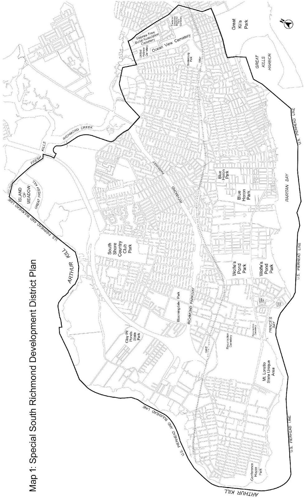
“Designated open space” is a portion of the open space network located on a zoning lot as shown on the District Plan (Map 3 in Appendix A), and is to be preserved in its natural state in accordance with the provisions of the Special South Richmond Development District.
Open space network
The “open space network” is a planned system of open spaces as shown on the District Plan (Map 3 in Appendix A), which includes public parks, designated open space and the waterfront esplanade.
Plan review site
A “plan review site” is any zoning lot that contains one or more acres, where there is a proposed development, enlargement, site alteration, or subdivision of such zoning lot into two or more zoning lots#.
Site alteration
A “site alteration” is an alteration on any vacant tract of land, land with minor improvements or any tract of land containing buildings or other structures, which includes permanent topographic modifications, removal of topsoil, removal of trees of six-inch caliper or more, excavating, filling, dumping, changes in existing drainage systems, whether or not a permit is required from the Department of Buildings or other public agencies.
Tree credit
A “tree credit” is a credit for preserving an existing tree or for planting a new tree which is counted towards tree requirements.
Waterfront esplanade
The “waterfront esplanade” is a pedestrian way to be provided for public use within the open space network along the Raritan Bay waterfront, as shown on the District Plan (Map 3 in Appendix A).
General Provisions
In harmony with the general purpose and intent of this Resolution and the general purpose of the Special South Richmond Development District, the regulations of the districts upon which this Special District is superimposed are supplemented or modified in accordance with the provisions of this Chapter. Except as modified by the express provisions of this Chapter, the regulations of the underlying districts remain in effect. In flood zones, or for transit-adjacent sites, as defined in Section 66-11 (Definitions), in the event of a conflict between the provisions of this Chapter and the provisions of Article VI, Chapter 4 (Special Regulations Applying in Flood Hazard Areas), or Article VI, Chapter 6 (Special Regulations Applying Around Mass Transit Stations), the provisions of Article VI shall control.
Property within the jurisdiction and control of the Department of Environmental Protection shall be exempt from the provisions of this Chapter where such property is an existing or planned portion of the Staten Island Bluebelt intended to support best management practices of stormwater.
An application to the City Planning Commission for a certification, authorization or special permit respecting a development, enlargement, or site alteration shall include a survey map, prepared by a licensed land surveyor and dated no more than two years prior to the date of filing an application, showing:
(a) existing topography at two foot contour intervals;
(b) the location of all existing buildings or other structures and the location of all proposed buildings or other structures;
(c) the location of individual existing trees of six inch caliper or more;
(d) the location of any elements of the open space network on or adjacent to the zoning lot; and
(e) the location of any areas of no land alteration, streams, and natural watercourses;
and such other information as may be required by the Commission for its determination as to whether or not the certification, authorization or special permit is warranted.
- Applications for authorization or special permit which were adopted prior to November 2, 2023, may be continued pursuant to the terms of such authorization or special permit or as such terms may be subsequently modified.
Continuance of such application shall be subject to the provisions of Sections 11-42 (Lapse of Authorization or Special Permit Granted by the City Planning Commission Pursuant to the 1961 Zoning Resolution) and 11-43 (Renewal of Authorization or Special Permit). - Applications for certification granted by the Commission prior to November 2, 2023, may be continued pursuant to the regulations in effect on the date that such certification was granted.
District Plan (Appendix A)
The District Plan for the Special South Richmond Development District shows the open space network, designated open space, waterfront esplanade, and building setback lines. The elements of the District Plan are set forth in Appendix A, which is hereby incorporated as an integral part of the provisions of this Chapter.
Any subdivision of a plan review site that is proposed to take place within the Special District shall be filed with the Department of City Planning, and the Chairperson of the City Planning Commission shall certify that subdivision of such plan review site:
- does not contain, or have frontage along, any District Plan Element listed in Section 107-20 (DISTRICT PLAN ELEMENTS), inclusive;
- does not contain an area of no land alteration;
- does not exceed the rate of two tree credits per 1,000 square feet of lot area; and
- does not have a violation for tree removal without prior permission or approval and no trees have been removed since November 2, 2023, unless permitted pursuant to Section 107-312 (Regulations within plan review sites).
In the case of a subdivision which does not comply with the above conditions, subdivision of such plan review site shall not be permitted unless authorized by the Commission pursuant to Section 107-64 (Future Subdivision of Certain Plan Review Sites).
The subdivision plan for the plan review site shall include a survey map in accordance with the requirements set forth in Section 107-03 (Requirements for Certification, Authorization or Special Permit Application).
For the purpose of applying the provisions of this Section, a subdivision includes the reconfiguration of a zoning lot in a manner that would reduce the area of such zoning lot.
Applicability of Article VI
The Chairperson of the City Planning Commission may, by certification, modify or waive a required visual corridor, as defined in Section 62-11, with respect to developments, including minor modifications thereto, that contain designated open space and a portion of the waterfront esplanade, where such development is conditioned upon a restrictive declaration that includes a site plan for such development, including provisions for public access to such designated open space and waterfront esplanade, provided that at least one required visual corridor continues to be provided pursuant to the restrictive declaration.
For zoning lots in flood zones with single- or two-family detached residences utilizing the provisions for cottage envelope buildings, as defined in Section 64-11 (Definitions), the provisions of this Chapter pertaining to minimum lot area, lot width, and minimum sizes of front yards and side yards shall not apply, and in lieu thereof, the underlying district regulations shall apply for the purposes of determining the applicability of the definition of cottage envelope buildings, and the particular amount of relief permitted pursuant to Section 64-33 (Cottage Envelope Buildings), inclusive.
SPECIAL REQUIREMENTS
For a site alteration, or a development, or enlargement, no certificate of occupancy or sign-off of a permit, as applicable, shall be issued by the Department of Buildings until the planting requirements of the following provisions, as applicable, have been satisfied, and reflected on an as-built survey, tree schedule, or any such information as may be required:
Section 107-32 (Tree Requirements)
Section 107-48 (Special Landscaping and Buffering Provisions).
DISTRICT PLAN ELEMENTS
All land in the open space network as shown on the District Plan (Map 3 in Appendix A), except public parks, and all zoning lots along an arterial as shown on the District Plan (Map 2 in Appendix A), are subject to the provisions of this Section, inclusive.
The City Planning Commission may adjust the boundaries of a designated open space on a zoning lot provided that such adjustment will not place the new boundary closer than 60 feet to a watercourse. As a condition for such adjustment in the boundaries, the Commission shall find that:
(a) such adjustment shall:
(1) result in a substantial improvement in the quality and usefulness of the designated open space; and
(2) permit development which better satisfies the purpose of this Chapter and include new features in the designated open space which will be at least equal in quality to those which are displaced from it; and
(3) provide an equivalent area replacement for the area removed from the designated open space; or
(b) such adjustment shall:
(1) be permitted to exclude:
(i) a zoning lot which is contiguous to exempted zoning lots along at least two lot lines; or
(ii) a zoning lot which would otherwise be contiguous to exempted zoning lots along at least two lot lines but for the separation by a street; or
(iii) streets abutting exempted zoning lots; and
(2) not substantially alter the utility and quality of the designated open space; or
(c) such adjustment shall:
(1) be in conjunction with a public improvement project approved by the City prior to September 11, 1975, for funding to exclude in whole or in part the bed of a mapped street and/or adjacent zoning lots or portions thereof; and
(2) not substantially alter the utility and quality of the open space network; or
(d) such adjustment shall:
(1) exclude, in whole or in part, private property contiguous with a public park which has been mapped since September 11, 1975; and
(2) not preclude the continuity to the designated open space or the public pedestrian way or the waterfront esplanade; and
(3) not substantially alter the utility and quality of the designated open space.
Designated Open Space
Any development or site alteration on a zoning lot which contains designated open space as shown on the District Plan (Map 3 in Appendix A), shall require certification by the City Planning Commission that:
(a) such designated open space shall be preserved in its natural state by the owner of the zoning lot; and
(b) where required by the Commission, the applicant has complied with the provisions of Section 107-222 (Public pedestrian ways); and
(c) where required by the Commission, as indicated on the District Plan, that the applicant has complied with Section 107-23 (Waterfront Esplanade).
Within any designated open space, removal of trees, alteration of topography, development or enlargement of active recreational facilities, or the establishment of utility easements may be undertaken only in accordance with the provisions of this Section and Section 107-30 (NATURAL FEATURE REGULATIONS).
Planting, landscaping or provision of footpaths or sitting areas are permitted in any part of designated open space, provided that such improvements do not involve removal of trees or alteration of existing topography, and do not obstruct pedestrian movement within the public pedestrian ways.
Active recreational facilities
Designated open space may be used for active recreational facilities provided that the City Planning Commission certifies that such uses are compatible with the purposes of the open space network and have minimal impact on tree removal, topographic alterations or drainage conditions.
Active recreational facilities may include swimming pools, tennis courts or facilities and equipment normally found in playgrounds, and shall comply with the use regulations of the underlying district.
In the development of active recreational facilities, no individual trees of six-inch caliper or more shall be removed except by special authorization of the Commission in accordance with the provisions of Section 107-65 (Modification of Natural Feature Regulations). Active recreational facilities shall not be allowed within 60 feet of any watercourse in designated open space unless the Commission certifies that a location closer to such watercourse will not adversely affect the natural character of the watercourse or its drainage function. The Commission, where appropriate, shall be guided by the reports from other City agencies involved in land contour work, storm water drainage systems or similar operations.
If the City of New York acquires an easement for public access to any designated open space on which a building has been, is being or could be in the future, constructed in accordance with the provisions of this Chapter, the City's acquisition of an easement shall not affect the qualifications of the designated open space for satisfying lot area requirements, yard requirements, floor area or lot coverage restrictions or open space requirements as provided in Section 107-224 (Qualification of designated open space as lot area for bulk computations) and shall not be deemed to create a non-compliance.
Public pedestrian ways
For any site alteration, development, or enlargement on a zoning lot which contains designated open space, the City Planning Commission shall certify whether or not the applicant shall be required to provide a public pedestrian way through a portion of the designated open space.
When a public pedestrian way is required, it shall be built and maintained by the owner of the zoning lot and shall be accessible to the public at all times. The public pedestrian way shall be improved at the time the site alteration, enlargement, or development takes place.
The location and dimension of such pedestrian way shall be determined by the Commission. The owner of the zoning lot may request the City to take an easement on the property. If the City of New York acquires an easement for public access to any designated open space on which a building has been, is being or could be in the future, constructed in accordance with the provisions of this Chapter, the City's acquisition of an easement shall not affect the qualifications of the designated open space requirements as provided in Section 107-224 (Qualification of designated open space as lot area for bulk computations) and shall not be deemed to create a non-compliance.
The following shall not be considered as obstructions when located in designated open space:
(a) Awnings and other sun control devices, pursuant to Section 23-311 (Permitted obstructions in all yards, courts and open areas);
(b) Balconies, unenclosed, subject to the provisions of Section 23-62;
(c) Eaves, gutters or downspouts projecting into such designated open space not more than 16 inches;
(d) Fences or walls, conditioned upon certification by the City Planning Commission that:
(1) such fences or walls will not obstruct or preclude public access or circulation of pedestrians, cyclists or horseback riders through the public easement within designated open space; and
(2) the location, size, design and materials of such fences or walls are appropriate to the character of the designated open space;
(e) Qualifying exterior wall thickness, pursuant to Section 23-311;
(f) Solar energy systems on walls pursuant to Section 23-311.
No accessory off-street parking facilities shall be permitted in designated open space. No building or other structure shall be erected in designated open space except as permitted by the provisions of Section 107-221 (Active recreational facilities). Any existing building or other structure located within the designated open space on November 2, 2023, and not complying with the provisions of this Section or the other Sections specified in the preceding paragraph, shall not be enlarged but may be continued as a non-conforming use or non-complying building subject to the applicable provisions of Article V (Non-conforming Uses and Non-complying Buildings) in accordance with the underlying district regulations.
Designated open space on a zoning lot may count as lot area for the purposes of the applicable regulations on yards, floor area ratio, open space ratio, open space, lot coverage, lot area or density, provided that the area of the designated open space claimed as lot area does not exceed the area of the zoning lot located outside the designated space. For a single-family residence, any portion of a zoning lot occupied by designated open space shall count as lot area for the purposes of satisfying minimum density requirements only pursuant to this Section.
Where the area of the designated open space claimed as lot area exceeds the above permitted amount, the provisions of Section 107-72 (Qualification of Designated Open Space as Lot Area) shall apply.
Any designated open space, or portion thereof, claimed as required open space or used to satisfy the lot coverage restrictions for a development containing residences shall be accessible to and usable by all residents of the zoning lot.
In the case of a large-scale residential development, any designated open space, or portion thereof, that qualifies as lot area may be used as common space.
This section shall apply to any tract of land containing designated open space that is developed as a unit in single ownership and where the area of the designated open space claimed as lot area for zoning computation does not exceed the area of that portion of the tract of land not located within designated open space. Such a tract of land may contain a single zoning lot or two or more zoning lots which are contiguous or would be contiguous except for their separation by a street.
In all Residence Districts, except R1-1 Districts, for all permitted residential uses on such tract of land, the total floor area or dwelling units generated by that portion of the designated open space claimed as lot area by the applicable district regulations may be distributed without regard for zoning lot lines, for all zoning lots wholly within such tract of land. The total open space required or lot coverage permitted for such tract of land may be located anywhere within the tract of land without regard for zoning lot lines.
No transfer of floor area or dwelling units shall be permitted from a zoning lot not containing any designated open space.
The site plan and bulk distribution for the entire tract of land shall be recorded in the land records and indexed against all zoning lots in such tract of land.
Furthermore, the minimum lot area and lot width regulations, yards and spacing between buildings regulations shall not apply along portions of streets or lot lines wholly within such tract of land, provided that:
(a) the maximum lot coverage on any zoning lot shall not exceed 50 percent of the lot area;
(b) the minimum distance between buildings on the same or adjacent zoning lots across a common side lot line is not less than 10 feet; and
(c) the minimum distance between buildings on adjacent zoning lots across a common rear lot line shall not be less than 40 feet.
Waterfront Esplanade
When a zoning lot containing a portion of the waterfront esplanade, as shown on the District Plan (Map 3 in Appendix A) is developed, the location and design of the waterfront esplanade shall be certified by the City Planning Commission and such waterfront esplanade shall conform to the guidelines and standards established by the Department of City Planning in consultation with the Department of Transportation and the Department of Parks and Recreation.
The waterfront esplanade shall be built and maintained by the owner of a zoning lot on which the esplanade is shown on the District Plan, except where such zoning lot has been developed prior to September 11, 1975. Where such waterfront esplanade is not accessible to the public, the Commission may require the owner of the zoning lot to provide public access to such a waterfront esplanade from a public right-of-way through the zoning lot.
The waterfront esplanade shall be either built at the same time that the zoning lot is developed or the Commission may allow the owner to comply with Section 107-24 (Special Regulations for Arterials or Railroad Rights of Way).
The owner of a zoning lot may request the City to take an easement on the property. If the City of New York acquires an easement for public access to any designated open space on which a building has been, is being or could be in the future constructed in accordance with the provisions of this Chapter, the City's acquisition of an easement shall not affect the qualifications of the designated open space for satisfying lot area requirements, yard requirements, floor area or lot coverage restrictions or open space requirements as provided in Section 107-224 (Qualification of designated open space as lot area for bulk computations) and shall not be deemed to create a non-compliance.
Along the following streets designated as arterials or along a designated railroad, special regulations relating to restriction of access and setback of buildings apply as set forth in this Section.
Arterials
Hylan Boulevard
Woodrow Road
Amboy Road
Frontage roads for Richmond Parkway
Huguenot Avenue
Page Avenue
Arthur Kill Road
Service roads for West Shore Expressway
Richmond Avenue
Railroads
The Staten Island Rapid Transit right-of-way.
In accordance with the primary function of an arterial to accommodate vehicular through traffic, access is restricted to arterials pursuant to paragraph (a) of Section 107-241 (Special provisions for arterials).In addition, along portions of arterials as indicated on Maps 2.1 through 2.4 (Arterial Setback Plan) in Appendix A of this Chapter, the building setback provisions of paragraph (b) of Section 107-241 apply.
Special provisions for arterials
Along those streets designated as arterials, the following regulations shall apply:
- Access restrictions
Curb cuts are not permitted along an arterial street on zoning lots with frontage on an improved non-arterial street. For zoning lots with frontage only on an improved arterial street, one curb cut is permitted along such arterial street. For purposes of this Section, adjoining zoning lots in the same ownership or control on November 2, 2023, shall be treated as a single zoning lot. For any zoning lot which includes an area plan approved by the City Planning Commission, no curb cut shall be allowed except where a curb cut is designated on such area plan. Such access restrictions with regard to curb cuts shall not apply to schools, hospitals and related facilities, police stations, or fire stations.
For a zoning lot with no less than 100 feet of frontage on an arterial street, the Commissioner of Buildings may approve curb cuts that exceed the access restrictions listed above where the Commissioner of Transportation submits a letter certifying that such additional curb cuts are necessary to avoid adverse effects on the traffic operations and safety of the arterial, or that such curb cuts will not adversely affect traffic operations and safety on the arterial including, but not limited to, all curb cut locations on an arterial street by either implementing a traffic pattern serving right-turn only movements or the implementation of traffic signalization, or other reasons acceptable to the Commissioner of Transportation. - Building setback
In all districts excluding Commercial Districts, along portions of the arterials, as indicated on the District Plan (Maps 2.1 through 2.4 in Appendix A of this Chapter), a 20 foot building setback shall be provided for the full length of the front lot line abutting such arterial. The front building setback area shall be unobstructed from its lowest level to the sky except as permitted by this Section. Where a front building setback area at least 35 feet in depth is provided, such setback area may be used for required accessory off-street parking or loading facilities. No portion of such required setback area may be used for open storage.
In the case of the service roads of the West Shore Expressway, a 30 foot building setback shall be provided and required off-street parking and loading facilities are permitted within such setback. Within the required front building setback, there shall be provided one tree of three-inch caliper or more, pre-existing or newly planted, for each 400 square feet of such front open area, unless waived pursuant to the provisions of paragraph (c) of Section 107-483 (Planting and screening for parking areas). The trees shall be selected in accordance with the provisions of Section 107-32 (Tree Requirements).
For all developments on zoning lots immediately adjacent to the Staten Island Rapid Transit right-of-way, a building setback of at least 20 feet in depth, unobstructed from its lowest level to the sky, except as permitted herein, shall be provided along the lot line immediately adjacent to the right-of-way of such railroad. Such building setback shall be measured perpendicular to such lot line, as indicated on the District Map. Within such building setback area, unless the area is within a street or is waived according to the planting waiver provisions of paragraph (c) of Section 107-483 (Planting and screening for parking areas), there shall be provided one tree of three-inch caliper or more, pre-existing or newly planted, for each 400 square feet of such open area. Tree species shall be selected in accordance with Section 107-32 (Tree Requirements).
NATURAL FEATURE REGULATIONS
Any development, enlargement resulting in changes to lot coverage, or site alteration shall comply with the provisions of this Section, inclusive.
All zoning lots shall comply with the provisions of Sections 107-31 (General Regulations for Natural Features), inclusive, and 107-32 (Tree Requirements).
In addition, regulations within areas of designated open space are set forth in Section 107-311 (Areas within designated open space).
Any plan review site shall also comply with the provisions of Section 107-312 (Regulations within plan review sites).
Any application to the Department of Buildings for a site alteration, development, or enlargement shall include a survey map in accordance with the requirements set forth in Section 107-03 (Requirements for Certification, Authorization or Special Permit Application).
A site plan for such application shall also include the location of any area of no disturbance, proposed paving, and shall identify those trees proposed to be removed and proposed to be preserved.
Except for any existing natural feature which is unsafe and the removal of which is required by the Department of Buildings to eliminate hazardous conditions, no site alteration may take place except as provided in this Section, inclusive.
No modification of topography shall take place within eight feet of a tree that is counted toward minimum tree credits pursuant to the provisions of Section 107-32 (Tree Requirements).
Within any zoning lot which is not a plan review site, tree removal shall be permitted in areas that do not contain designated open space, provided that such zoning lot complies with the provisions of Section 107-32.
Within designated open space on a zoning lot, any site alteration shall be permitted only by authorization of the City Planning Commission pursuant to Section 107-65 (Authorization for Modifications of Natural Features).
On any portion of a plan review site not within designated open space, development, enlargement, or site alteration shall be permitted only in accordance with the provisions of this Section or by authorization of the City Planning Commission pursuant to the provisions of Section 107-65 (Authorization for Modifications of Natural Features) or by certification of the Chairperson of the City Planning Commission pursuant to the provisions of Section 107-51 (Certification of Certain Plan Review Sites).
The ground elevation of land existing on November 2, 2023, may be modified by up to two feet of cut or fill, provided that such modification shall not result in the destruction of trees of six-inch caliper or more, unless authorized pursuant to other provisions of this Chapter. Modification of topography to a greater extent and removal of trees of six-inch caliper or more shall only be permitted:
- within 20 feet of an existing building’s foundations or in an area designated for utilities;
- in order to meet the legal mapped grades of a street, the existing topography of that portion of the zoning lot abutting such street may be modified to create a slope on the zoning lot of not less than one foot vertical to each two feet horizontal, provided the slope is landscaped to prevent erosion;
- within an existing group parking facility, or within existing landscaping required pursuant to Section 107-483 (Planting and screening for parking areas), which does not result in the removal of parking spaces or travel lanes;
- where such modification of topography takes place more than 20 feet from the boundary of an area of designated open space, a side lot line, or a rear lot line; or
- where such tree interferes with another tree of six-inch caliper or more, and such tree to be preserved belongs to a species pursuant to the provisions of Section 107-32 (Tree Requirements).
If an existing tree of six-inch caliper or more is removed without prior approval from the Department of Buildings or the City Planning Commission and does not meet the provisions of this Section, any permit issued by the Department of Buildings for a site alteration, enlargement, development, or any use on the zoning lot shall not be granted a letter of completion, certificate of occupancy, or similar sign-off until such tree is replanted, or proposed to be replaced, as applicable, in accordance with Section 107-32. A violation for tree removal without prior permission or approval shall be recorded against such site.
Tree Requirements
For all zoning lots, newly planted trees shall be planted no closer than eight feet from any other tree and be of a species selected from the New York City Native Species Planting Guide (as issued and revised by the Department of Parks and Recreation), or its successor.
- Planting in Residence Districts or on a zoning lot containing a group parking facility with fewer than 10 parking spaces
In connection with any development, site alteration, or enlargement in a Residence District, or on any zoning lot that contains a group parking facility with fewer than 10 parking spaces, that are not fully enclosed, newly planted trees of at least one-inch caliper and less than six-inch caliper, or pre-existing trees of at least six-inch caliper, shall be provided on the zoning lot at the rate of one tree credit for each 1,000 square feet of lot area or portion thereof.
A newly planted tree of between one and two-inch caliper shall have 0.5 tree credits, and a newly planted tree greater than two-inch caliper but less than six-inch caliper shall have one tree credit. Newly planted trees appearing on a site plan in an approved application may be counted toward tree credits on site plans for future applications if they have not yet grown to a six-inch or greater caliper, provided that they remain in good health and continue to comply with the standards set forth in this Section.
Any existing tree of at least six-inch caliper which is preserved and has no new paving, development, enlargement, or modification of topography within eight feet of such tree, shall have one tree credit for the first six inches of caliper and an additional tree credit for each additional three inches of caliper. - Planting for parking areas
Any development or enlargement on a zoning lot that contains a group parking facility with 10 or more parking spaces that are not fully enclosed shall be subject to the tree planting and screening requirements of Section 107-483.
For any development, site alteration or enlargement which is required to provide trees in accordance with the provisions of paragraph (a) of Section 107-32, the City Planning Commission may allow the substitution of other plant material for such required trees, provided a detailed landscaping plan is filed with the Commission for approval and certification. A copy of such approved landscaping plan shall be filed with the Department of Buildings by the Commission.
For any development or enlargement, the Chairperson of the City Planning Commission may modify the applicable regulations governing the location of required parking spaces, driveways and curb cuts where the Chairperson certifies to the Commissioner of Buildings that such modifications are necessary so as to avoid the destruction of existing topography and trees of six-inch caliper or more.
The underlying use, bulk and parking regulations shall apply. However, for zoning lots that are not qualifying residential sites, such provisions are modified by the provisions of this Section, inclusive.
Type of Residence
Semi-detached or attached single-family residences in R2 Districts and attached single- or two-family residences in R3-1 Districts may be permitted by special permit of the City Planning Commission in accordance with the provisions of Section 107-74 (Modification of Permitted Use Regulations). Such residences shall comply with the minimum lot area and lot width requirements as set forth in the table in Section 107-42.
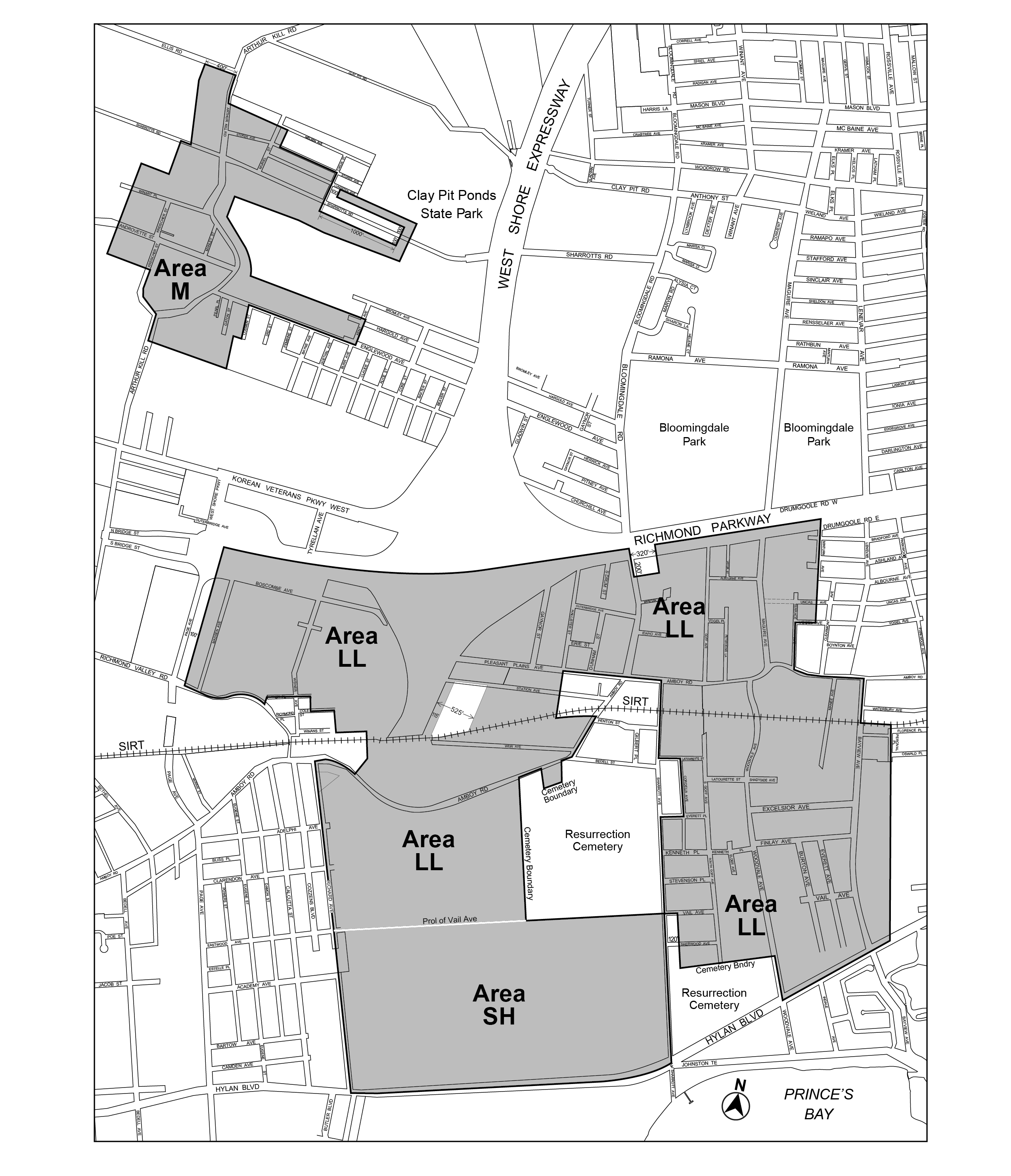
In Area SH, as shown on the District Plan (Map 4 in Appendix A), any development or enlargement comprised of affordable independent residences for seniors shall be permitted upon certification of the Chairperson of the City Planning Commission that:
(a) such development or enlargement will contain not more than 250 dwelling units of affordable independent residences for seniors, individually or in combination with other developments or enlargements within Area SH that have received prior certification pursuant to this Section;
(b) a site plan has been submitted showing a detailed plan demonstrating compliance with the provisions of this Chapter; and
(c) such residences comply with the use and bulk regulations of R3-2 Districts, as modified by this Chapter. The provisions applicable to qualifying residential sites in Section 23-21 (Floor Area Regulations for R1 Through R5 Districts) shall not apply.
Any development or enlargement that results in a total of more than 250 dwelling units of affordable independent residences for seniors in Area SH shall be permitted only upon authorization of the City Planning Commission, pursuant to Section 107-672 (In Area SH).
The bulk regulations of this Chapter applicable to residential buildings shall apply to all zoning lots in lower density growth management areas containing buildings used for:
(a) ambulatory diagnostic or treatment health care facilities, listed under Use Group III(B), except where such zoning lot contains buildings used for hospitals, as defined in the New York State Hospital Code, or long-term care facilities; or
(b) child care services as listed under the definition of school in Section 12-10 (DEFINITIONS), except where such zoning lot contains buildings used for houses of worship or, for zoning lots that do not contain buildings used for houses of worship, where the amount of floor area used for child care services is equal to 25 percent or less of the amount of floor area permitted for community facility use on the zoning lot.
All zoning lots shall follow the regulations of Section 23-11 (Lot Area and Lot Width Regulations), except as modified in this Section.
REQUIRED MINIMUM LOT AREA AND LOT WIDTH
|
Type of Residence |
District |
Minimum Lot Area (in sq. ft) |
Minimum Lot Width (in ft) |
|
Single- or two-family detached, or zero lot line, where permitted |
R3X1 |
4,750 |
50 |
|
R2 R3X |
3,325 |
35 |
|
|
|
R3A |
2,850 |
30 |
|
Semi-detached |
R3-1 R3-2 |
2,375 |
25 |
1 For zoning lots in Area LL as shown on the District Plan (Map 4 in Appendix A) of this Chapter
BY SPECIAL PERMIT (PURSUANT TO SECTION 107-74)
|
Type of Residence |
District |
Minimum Lot Area (in sq. ft) |
Minimum Lot Width (in ft) |
|
Semi-detached |
R2 |
2,375 |
25 |
|
Attached |
R2 R3-1 |
1,700 |
18 |
In R1, R2, R3-1, R3A, R3X, R4-1 and R4A Districts, the provisions of this Section shall apply to zoning lots containing buildings used for:
(a) ambulatory diagnostic or treatment health care facilities, as listed in Section 22-14 (Use Group 4), except where such zoning lot contains buildings used for hospitals, as defined in the New York State Hospital Code, or long-term care facilities; and
(b) child care service as listed under the definition of school in Section 12-10 (DEFINITIONS), except where:
(1) such zoning lot contains buildings used for houses of worship; or
(2) for zoning lots that do not contain buildings used for houses of worship, where the amount of floor area used for child care services is equal to 25 percent or less of the amount of floor area permitted for community facility use on the zoning lot.
The minimum lot area for such zoning lots containing ambulatory diagnostic or treatment health care facilities shall be 5,700 square feet, and the minimum lot area for such zoning lots containing child care services shall be 10,000 square feet. Where such uses are located on the same zoning lot, the applicable lot area requirement shall be allocated separately to each such use. In addition, each such zoning lot shall have a minimum lot width of 60 feet. Such lot width shall be applied as set forth in the definition of lot width in Section 12-10, provided that such lot width shall also be met along at least one street line of the zoning lot. No building, or portion thereof, shall be permitted between opposing side lot lines where such lot lines would be nearer to one another at any point than 60 feet.
For such zoning lots containing multiple buildings used in any combination for ambulatory diagnostic or treatment health care facilities, child care services or residences, the applicable minimum lot area and lot width requirements shall be allocated separately to each such building.
Subject to the requirements for maximum height of walls and required setbacks in Sections 23-42, 24-52 or 33-43, no building or other structure shall exceed a height of 50 feet unless modified by a special permit of the City Planning Commission, pursuant to Section 107-73 (Exceptions to Height Regulations).
Any required open space on a zoning lot which includes designated open space is subject to the special regulations set forth in Section 107-22 (Designated Open Space).
For buildings containing residences on zoning lots that include designated open space, driveways, private streets, open accessory parking spaces or open accessory off-street loading berths may occupy not more than the area set forth for the following districts:
(a) in R1, R2, R3-1, R3-2 and R4 Districts, not more than 50 percent of the required open space not within the designated open space; or
(b) in R3A, R3X, R4A and R4-1 Districts, not more than 50 percent of the lot area not occupied by buildings containing residences and not within the designated open space.
However, in all districts, a greater percentage may be so occupied if authorized by the City Planning Commission in accordance with the provisions of Section 107-661 (Modification of permitted obstructions).
Yard and Court Regulations
Side yards
In R2 and R3 Districts, for zoning lots containing only single- or two-family detached residences, two side yards, each with a minimum width of five feet, and a total width of 15 feet, shall be provided.
For community facility buildings or other buildings used for permitted non-residential uses in Residence Districts, the provisions of Section 24-35 (Minimum Required Side Yards) shall apply to such community facility buildings, except that no side yard shall have a width less than 10 feet and, in the case of buildings more than three stories in height, the required total width of both side yards shall not be less than 25 feet.
Where greater widths of side yards are required by the provisions of Section 24-35 than by the provisions of this Section, such requirement of greater width shall apply.
On application, the City Planning Commission may, by certification, modify the underlying rear yard regulations and thereby allow single- or two-family residences to be built on the side or rear lot line, provided the following conditions are satisfied:
(a) When a building is located on the side lot line, the entire required side yard equivalent shall be provided along the other side lot line of the same zoning lot. On the adjacent zoning lot there shall be a side yard of at least 10 feet, abutting the building wall which is located on the side lot line.
(b) When a single- or two-family residence is located on the rear lot line, the zoning lots abutting the entire rear lot line shall provide a rear yard of at least 40 feet. If the building on either zoning lot has a height greater than two stories, then such building shall have a 10-foot rear setback above the height of the second story.
(c) When single- or two-family residences share a party wall along the rear lot line, if at any level either building is set back from the rear lot line, each building shall have a setback at the same height and such rear setback shall be at least 20 feet in depth.
The Commission shall also find that:
(1) such modifications of side or rear yards or equivalents blend harmoniously with the entire development;
(2) there is no adverse effect with regard to adequate light and air to the residences;
(3) such modification results in the maximum preservation of trees;
(4) there is an agreement which provides access for maintenance of the building wall located on the lot line; and
(5) a condition to the grant of any certification shall be that the requirements of Section 107-90 (SPECIAL ADMINISTRATIVE PROVISIONS FOR RECORDATION) have been satisfied.
Court regulations
The court regulations as set forth in Section 23-35 shall apply except as modified by this Section.
For any building containing residences not more than one story in height, the area of an inner court shall not be less than 225 square feet and the minimum dimension of such inner court shall not be less than 15 feet.
For any building containing residences more than one story in height, the area of an inner court shall not be less than 400 square feet and the minimum dimension of such inner court shall not be less than 20 feet.
No court regulations shall apply to single- and two-family detached residences.
Special Parking Regulations
For the purposes of this Chapter, the waiver provision set forth in Section 36-231 (In districts with high, medium or low parking requirements) shall not apply to any development in the Special District.
For the purposes of this Chapter, no accessory group parking facility for non-residential uses shall be permitted anywhere on a plan review site, or any zoning lot that contained one or more acres on November 2, 2023, except as set forth in Sections 107-51 (Certification of Certain Plan Review Sites) or 107-68 (Modification of Group Parking Regulations).
Location of required parking
For a residential building on a zoning lot containing an area of no land alteration or designated open space, the provisions of Section 25-622 (Location of parking spaces in lower density growth management areas) that do not permit open off-street parking between the street line and the street wall or prolongation thereof of a building shall not apply.
For any commercial or manufacturing development on a zoning lot adjoining a Residence District boundary, there shall be in the open area required by the provisions of Sections 33-29 and 43-30 (SPECIAL PROVISIONS APPLYING ALONG DISTRICT BOUNDARIES) along the lot line adjoining the Residence District, a strip at least four feet wide, densely planted with evergreen shrubs at least four feet high at the time of planting and complying with the provisions applicable to screening for parking areas as set forth in Section 107-483 (Planting and screening for parking areas).
Where an existing residential use is located adjacent to a proposed manufacturing or commercial development, the developer shall plant along that part of the side or rear lot line adjacent to a residential use, a row of evergreen shrubs at least four feet high at the time of planting and which are of a type which may be expected to form a year-round dense screen at least six feet high within three years, or trees selected from the New York City Native Species Planting Guide (as issued and revised by the Department of Parks and Recreation), or its successor, and spaced at 10 feet on center. Such screening shall be maintained in good condition at all times.
Zoning lots that contain a group parking facility with 10 or more parking spaces that are not fully enclosed, shall be subject to paragraphs (a) and (b) of this Section and may be subject to paragraph (c) of this Section.
(a) Tree planting requirements for open parking
The provisions of Section 37-921 (Perimeter landscaping) shall apply to all facilities. In addition, one tree, of three inch caliper or more, pre-existing or newly planted, shall be provided for each four open parking spaces and may be located in the perimeter landscaped area of the parking area or in planting islands within the parking area.
However, where 30 or more open parking spaces are provided, at least 50 percent of the required trees shall be located within planting islands within the parking area. Such planting islands shall have a minimum area of 150 square feet of pervious surface and comply with the requirements of paragraphs (a), (b) and (c) of Section 37-922 (Interior landscaping).
For open parking areas with at least 36 parking spaces, the total number of trees required pursuant to Section 37-922 shall be superseded by the number of trees required pursuant to this Section.
Notwithstanding the above, for open parking areas where solar canopies will cover more than 75 percent of the parking spaces in an accessory off-street parking facility or public parking lot, or any portion thereof with more than 10 parking spaces, the provisions of Section 37-923 (Alternative compliance for solar canopies), including associated applicability and modifications to the provisions of Sections 37-921 and 37-922, may be applied in lieu of the provisions of this Section.
(b) Screening requirements
For open parking areas or parking garages located on the ground floor and not fully enclosed, such non-enclosed portion shall be screened from all adjoining zoning lots by a landscaped area at least four feet in width, densely planted with shrubs maintained at a maximum height of three feet. Open parking areas shall also be screened from all adjoining streets by a perimeter landscaped area at least seven feet in width in accordance with Section 37-921 (Perimeter landscaping). Such perimeter landscaped area may be interrupted only by vehicular entrances and exits. Sidewalks that provide a direct connection between the public sidewalk and a pedestrian circulation route within the parking area may also interrupt a perimeter landscaped area.
In addition, such screening shall be maintained in good condition at all times and may be interrupted by normal entrances and exits.
(c) Planting waiver
Tree planting and screening requirements may be waived if the Commissioner of Buildings certifies that planting is unfeasible due to:
(1) unique geological conditions, such as excessive subsurface rock conditions or high water table;
(2) underground municipal infrastructure; or
(3) a City, State or Federal mandated brownfield remediation that requires the site to be capped.
Such waiver shall be based on a report prepared by a licensed engineer that such conditions exist.
For developments in Residence Districts, trees provided in accordance with the provisions of this Section may be counted for the purposes of meeting the requirements of paragraph (a) of Section 107-32. Furthermore, for developments and enlargements in Commercial or Manufacturing Districts, which provide trees in accordance with the provisions of this Section, the requirements of paragraph (a) of Section 107-32 shall not apply.
In Area M, as shown on the District Plan (Map 4 in Appendix A) the regulations of the underlying districts and the Special District are supplemented or modified in accordance with the provisions of this Section. Except as modified by the express provisions of this Section, the regulations of the underlying districts and the Special District remain in effect.
(a) Residential uses existing prior to August 17, 1995 shall be considered conforming and when an existing building containing such uses is damaged or destroyed by any means, it may be reconstructed to its bulk prior to such damage or destruction or to R3X District bulk requirements, whichever is greater.
(b) Residential extensions shall be subject to all of the R3X District regulations and the applicable Special District regulations except that an existing detached building may contain non-residential uses in addition to not more than two dwelling units.
(c) Non-residential uses shall be located below the lowest story occupied in whole or in part by residential uses.
(d) Floor area in a building originally designed as one or more dwelling units that has been continuously vacant for two or more years prior to the date of filing an alteration application, may be re-occupied for residential use.
(e) Residential enlargements not to exceed 500 square feet shall be permitted subject to all of the R3X District regulations and the applicable Special District regulations, provided that there is no increase in the number of dwelling units and that there is no disturbance of the soil.
(f) Residential developments, and residential enlargements where there is a disturbance of the soil, shall be subject to the provisions of Section 107-69 (Residential Uses in Area M).
Special bulk regulations
The maximum floor area ratio for two or more uses on a zoning lot shall be determined by the use that is permitted the greatest floor area ratio in Area M (Map 4 in Appendix A), provided that the floor area occupied by each use does not exceed the amount permitted by the floor area ratio for that use in Area M.
CERTIFICATIONS
Administrative certifications from the City Planning Commission are required, as set forth in various sections of this Chapter, in any one of the following circumstances:
- when certain plan review sites are subdivided, as set forth in Section 107-08 (Future Subdivision of Certain Plan Review Sites);
- when certain plan review sites meet the requirements set forth in Section 107-51 (Certification of Certain Plan Review Sites) and do not require an authorization pursuant to Section 107-60, inclusive;
- when a zoning lot contains designated open space, as set forth in Section 107-22 (Designated Open Space);
- where required yards or equivalents are to be modified as set forth in Section 107-465 (Modifications of special yard regulations for certain zoning lots);
- where plant material is substituted for required trees as set forth in Section 107-33 (Substitution of Other Plant Materials); or
- when a zoning lot contains a portion of the proposed waterfront esplanade, as set forth in Section 107-23 (Waterfront Esplanade).
- Any development or enlargement may modify applicable regulations governing the location of required parking spaces, driveways and curb cuts, as set forth in Section 107-34 (Preservation of Natural Features).
On a plan review site, for any enlargement or site alteration which does not comply with the provisions of Section 107-31 (General Regulations for Natural Features), the Chairperson of the City Planning Commission shall certify that:
- such plan review site does not:
(1) contain any of the district plan elements as set forth in Section 107-20 (DISTRICT PLAN ELEMENTS), inclusive;
(2) contain an area of no land alteration;
(3) exceed the rate of two tree credits per 1,000 square feet of lot area; and
(4) have a violation for tree removal without prior permission or approval and no trees have been removed since November 2, 2023, unless permitted pursuant to Section 107-312 (Regulations within plan review sites);
- new or existing tree planting shall satisfy tree requirements pursuant to Section 107-32 (Tree Regulations); and
- the resulting enlargement or site alteration does not require more than 10 additional accessory off-street parking spaces for a commercial, community facility, or manufaturing use.
Any enlargement or site alteration on a plan review site which does not comply with these conditions, or any development on a plan review site, shall require an authorization pursuant to Section 107-60 (AUTHORIZATIONS).
AUTHORIZATIONS
General Provisions
On application, the City Planning Commission may grant authorizations for modifications of specified regulations of this Chapter or of the underlying districts in accordance with the provisions of Sections 107-62 to 107-69, inclusive, relating to authorizations.
The Commission may prescribe appropriate conditions and safeguards in connection with the grant of such authorizations.
For any plan review site or for any zoning lot containing designated open space or an area of no land alteration, the City Planning Commission may authorize variations in the yard or court regulations as set forth in Section 107-46, inclusive, or in the location of parking, driveway or curb cut regulations as set forth in Sections 23-311 (Permitted obstructions in all yards, courts and open areas), 25-621 (Location of parking spaces in certain districts), 25-622 (Location of parking spaces in lower density growth management areas) and 25-632 (Driveway and curb cut regulations in lower density growth management areas) for the purpose of allowing proper arrangements of buildings, driveways or required parking areas so as to avoid the destruction of natural features.
As a condition for granting such authorizations, the Commission shall find that the proposed placement of buildings and arrangement of open spaces will not have adverse effects upon light, air and privacy on adjacent zoning lots and will preserve natural features in areas of no disturbance.
For any development containing residences, the City Planning Commission may authorize the location of buildings, on a single zoning lot without regard for spacing between buildings regulations, provided that the resultant spacing will not be reduced beyond an amount considered appropriate by the Commission and in no case by more than 15 percent of that required by Section 23-371 (Distance between buildings).
For any plan review site that does not comply with Section 107-08 (Future Subdivision of Certain Plan Review Sites), the City Planning Commission may authorize a future subdivision into two or more zoning lots, provided that the Commission finds that:
- to the greatest extent possible, all individual trees of six-inch caliper or more, the existing topography, and all land located within a designated open space, are preserved under future development options;
- such subdivision complies with the goals described in paragraph (c) of Section 107-00 (GENERAL PURPOSES);
- and where vehicular access and egress are located on an arterial, the location of such vehicular access and egress permits better site planning.
Any subdivision that is proposed to take place within the Special District after November 2, 2023, shall be filed with the City Planning Commission. A site plan and area plan shall indicate the distribution of bulk for the individual zoning lots submitted to the Commission. Such approved subdivision shall then be recorded in the land records and indexed against all zoning lots.
For the purpose of applying the provisions of this Section, a subdivision includes reconfiguration of a zoning lot in a manner that would change its area or any dimension of such zoning lot.
For any development, enlargement, or site alteration on plan review sites or within designated open space, the City Planning Commission may authorize modifications of the natural topography existing on November 2, 2023, beyond the amount specified in Section 107-31 (General Regulations for Natural Features), inclusive, or modification of tree regulations pursuant to Section 107-311 (Areas within designated open space) and Section 107-312 (Regulations within plan review sites), in accordance with the provisions of either paragraph (a) or (b) of this Section.
- For all zoning lots, the Commission may authorize modifications to natural features, provided that the Commission finds that:
- the modifications are the minimum necessary to facilitate the project;
- such modification of topography is necessary to accommodate any public amenities, as applicable, such as public pedestrian ways, the waterfront esplanade or active recreational facilities within a designated open space as required under the provisions of this Chapter;
- such modification will not cause unnecessary disturbance of the drainage pattern in the area;
- such modification will have minimal impact on the existing natural features of the surrounding area and will blend harmoniously with such area; and
- areas that contain natural features are preserved within a proposed area of no disturbance, especially those areas which are contiguous to designated open space, areas of no land alteration, or other area containing mostly natural features.
- In order to support the development of renewable energy infrastructure, for waterfront zoning lots in Manufacturing Districts that contain Water-Dependent (WD) uses, as set forth in Section 62-211, where the area allocated to such uses exceeds 75 percent of the land above water in the upland lot, the Commission may authorize modifications to natural features, provided that the Commission finds that:
- the WD use requires unenclosed operations, not limited to vehicle movement or storage, that would not be feasible without the modification of natural features;
- such modification is the minimum necessary to facilitate such use on the zoning lot;
- the WD use would provide a substantial environmental benefit; and
- such modification would not have an adverse effect on the surrounding area.
The Commission may prescribe appropriate conditions and safeguards to minimize adverse effects on the character of the surrounding area.
For developments containing residences on zoning lots partly within designated open space, the City Planning Commission, on application, may modify the requirements of Section 107-45 (Required Open Space for Residences) to permit more than 50 percent of the required open space, not within the designated open space, to be occupied by driveways, private streets, open accessory off-street parking spaces or open accessory off-street loading berths, if the Commission finds that such facilities are so arranged and landscaped as to afford an acceptable standard of amenity for the development and its surroundings.
On application, the City Planning Commission may grant an authorization modifying the building setback requirements of Section 107-241 (Special provisions for arterials), provided that the Commission finds that:
(a) the area of that portion of the zoning lot which is designated as designated open space on the District Plan in Appendix A of this Chapter, is at least equal to the area of the required building setback front yard or yards, or portion thereof, which is waived;
(b) along any front lot line abutting an arterial, a front setback shall be provided having a depth to be determined by the Commission and which shall be improved in accordance with a landscape plan approved by the Commission; and
(c) building placement leaves adequate spaces for the provision of street trees.
In Area SH
The City Planning Commission may authorize developments that will result in more than 250 dwelling units of affordable independent residences for seniors in Area SH, as shown on the District Plan (Map 4 in Appendix A), provided such developments comply with the use and bulk regulations of R3-2 Districts, as modified by this Chapter. The provisions applicable to qualifying residential sites in Section 23-21 (Floor Area Regulations for R1 Through R5 Districts) shall not apply.
In order to grant such authorization, the Commission shall find that:
(a) such developments are part of a superior site plan;
(b) such residences are compatible with the character of the surrounding area; and
(c) the streets providing access to such residences are adequate to handle the traffic generated thereby or provision has been made to handle such traffic.
For a permitted commercial, community facility or manufacturing use on a plan review site or portion of a plan review site existing on November 2, 2023, the City Planning Commission may authorize accessory off-street parking spaces in a plan review site or portion of a plan review site existing on November 2, 2023. In order to grant such authorization, the Commission, upon a review of the site plan, shall find that:
- vehicular access and egress are located and arranged so as to draw a minimum of vehicular traffic to and through local streets in nearby residential areas;
- where vehicular access and egress are located on an arterial, such location affords the best means for controlling the flow of traffic generated by such use to and from such arterial, and does not unduly interfere with pedestrian traffic; and
- the design of the parking facility avoids undue conflict between pedestrian and vehicular movements in a manner that results in a better site plan.
The Commission may prescribe appropriate conditions and safeguards to minimize adverse effects on the character of the surrounding area and may, in appropriate cases, condition its authorization upon compliance with an approved site and landscaping plan. The Commission may also permit modifications to parking lot landscaping and maneuverability requirements only if such modifications preserve natural features.
Residential Uses in Area M
(a) The City Planning Commission may authorize developments, or enlargements of residential uses in excess of 500 square feet, or in any case where there would be a disturbance of the soil, for the following:
(1) zoning lots with residential or community facility uses existing on August 17, 1995; or
(2) zoning lots that have been vacant or land with minor improvements for at least two years immediately prior to the date of application for the authorization.
(b) No building shall be constructed for occupancy by both residential and manufacturing uses. All residential uses shall comply with the R3X District regulations and all commercial uses shall comply with the M1-1 District regulations. All developments or enlargements shall comply with the applicable Special District regulations:
(c) In authorizing new residential uses and residential enlargements, the Commission shall find that:
(1) the residential use will not be exposed to excessive noise, smoke, dust, noxious odor, toxic metals, safety hazards, or other adverse impacts from commercial or manufacturing uses;
(2) there are no open uses included under Sewage, Storm Water and Waste Infrastructure Use Group IV(B) or other open uses listed under Use Group IX(B) or Use Group X within 400 feet of the zoning lot;
(3) the residential use shall not adversely affect commercial or manufacturing uses in the Special District; and
(4) the authorization shall not alter the essential character of the neighborhood or district in which the use is located, nor impair the future use or development of commercial and manufacturing uses on nearby zoning lots.
In granting such authorization, the Commission may prescribe appropriate conditions and safeguards to minimize adverse effects on the character of the surrounding area.
SPECIAL PERMITS
General Provisions
For any development containing designated open space, the City Planning Commission may allow the amount of designated open space to be counted as lot area for bulk computations to exceed the amount permitted under Section 107-224.
As a condition for granting a permit for such modifications, the Commission shall find that:
(a) that for the occupants of the site itself, the ill effects of concentration of buildings or accessory off-street parking are avoided or overcome by the manner in which the buildings are sited and yards and other open areas arranged; and
(b) that the concentration of buildings or activities will not adversely affect any other zoning lot outside the development by restricting access of light and air, impairing privacy or creating traffic congestion.
For any development, the City Planning Commission may grant a special permit to modify the height regulations as set forth in Section 23-42 (Height and Setback Requirements in R1 Through R5 Districts) and Section 107-43, provided that the Commission finds that:
(a) such development is so located as not to impair the essential character of the surrounding area;
(b) by concentrating permitted floor area in a building or buildings of greater height covering less land, the preservation of existing topography, designated open space or the protection of an outstanding view from a public space, will be assured, and that such preservation would not be possible by careful siting of lower buildings containing the same permitted floor area and covering more land; and
(c) that the development's design proposals take full advantage of all special characteristics of the site.
For any development, the City Planning Commission may grant special permits to allow semi-detached or attached single-family residences in R2 Districts and attached single- or two-family residences in R3-1 Districts. As a condition for granting such special permits, the Commission shall find that:
(a) only by modifying the residential building type, the preservation of trees over six-inch caliper and of existing topography can be assured;
(b) by inclusion of the proposed residential building types, better standards of privacy and usable open space can be achieved; and
(c) if the zoning lot is located in the designated open space, the prohibition of development on the designated open space requires the permitted development to be concentrated in the remaining portion of the tract.
The City Planning Commission may grant special permits to allow adjustments in the boundaries of the designated open space on a zoning lot provided that such adjustment will not place the new boundary closer than 60 feet to a watercourse. As a condition for such adjustment in the boundaries, the Commission shall find that such adjustment will:
(a) result in a substantial improvement in the quality and usefulness of the designated open space; or
(b) permit development which better satisfies the purposes of this Chapter and that the new features which will be added to the designated open space will be at least equal in quality to those which are displaced from it; and
(c) provide an equivalent area replacement for the area removed from the designated open space.
The City Planning Commission may grant special permits for the construction of sewage disposal plants or pumping stations or community facility uses listed in Section 78-352 (Bonus for community facility space) in designated open space where such uses are permitted by the underlying district regulations provided the Commission finds that:
(a) an amount of open area outside the boundary of the designated open space, at least equal to the coverage of any building or other structure permitted under this Section, shall be added to the designated open space, and action shall be taken to change the boundary of the designated open space pursuant to Section 107-76 (Boundary Adjustments in Designated Open Space);
(b) such added open area forms a continuous part of the open space network, and does not interrupt or foreclose the continuity of a public pedestrian way;
(c) such added open area shall contain natural (aquatic, botanic, geologic or topographic) features that are equal or better in quality to those displaced by the development; and
(d) such sewage disposal plants and sewage pumping stations meet the requirements of Section 74-143, inclusive.
The City Planning Commission may prescribe appropriate conditions and safeguards to enhance the character of the designated open space.
On any zoning lot located partially within the designated open space, the City Planning Commission may grant a special permit to allow a building to encroach on the designated open space where development is not feasible without encroachment on the designated open space. As a condition for permitting such construction, the Commission shall find that the development, as authorized, will result in the minimum interference with the designated open space that must be permitted in order to allow reasonable development and bulk distribution under the regulations of the underlying district or as such regulations are modified by the provisions of this Chapter.
The Commission may prescribe appropriate conditions and safeguards to enhance the character of the designated open space.
When any yard requirement of the applicable district regulations is modified by the City Planning Commission pursuant to Section 107-46 (Yard and Court Regulations), prior to the filing of an application for any permit with the Department of Buildings, there shall be recorded in the Office of the County Clerk, County of Richmond, and indexed against such zoning lots to be developed as a unit, an instrument describing all conditions and restrictions required by the Commission for the development and use of such zoning lots. Recordation of instruments may be required in connection with any other zoning application hereunder. A certified copy of such instrument shall be submitted to the City Planning Commission upon recordation thereof.
The Special South Richmond Development District Plan is incorporated as Appendix A of this Chapter.
Appendix A
Special South Richmond Development District Plan
Map 1 — District Plan (9/11/75)
Map 2 — Arterial Setback Plan (11/2/23)
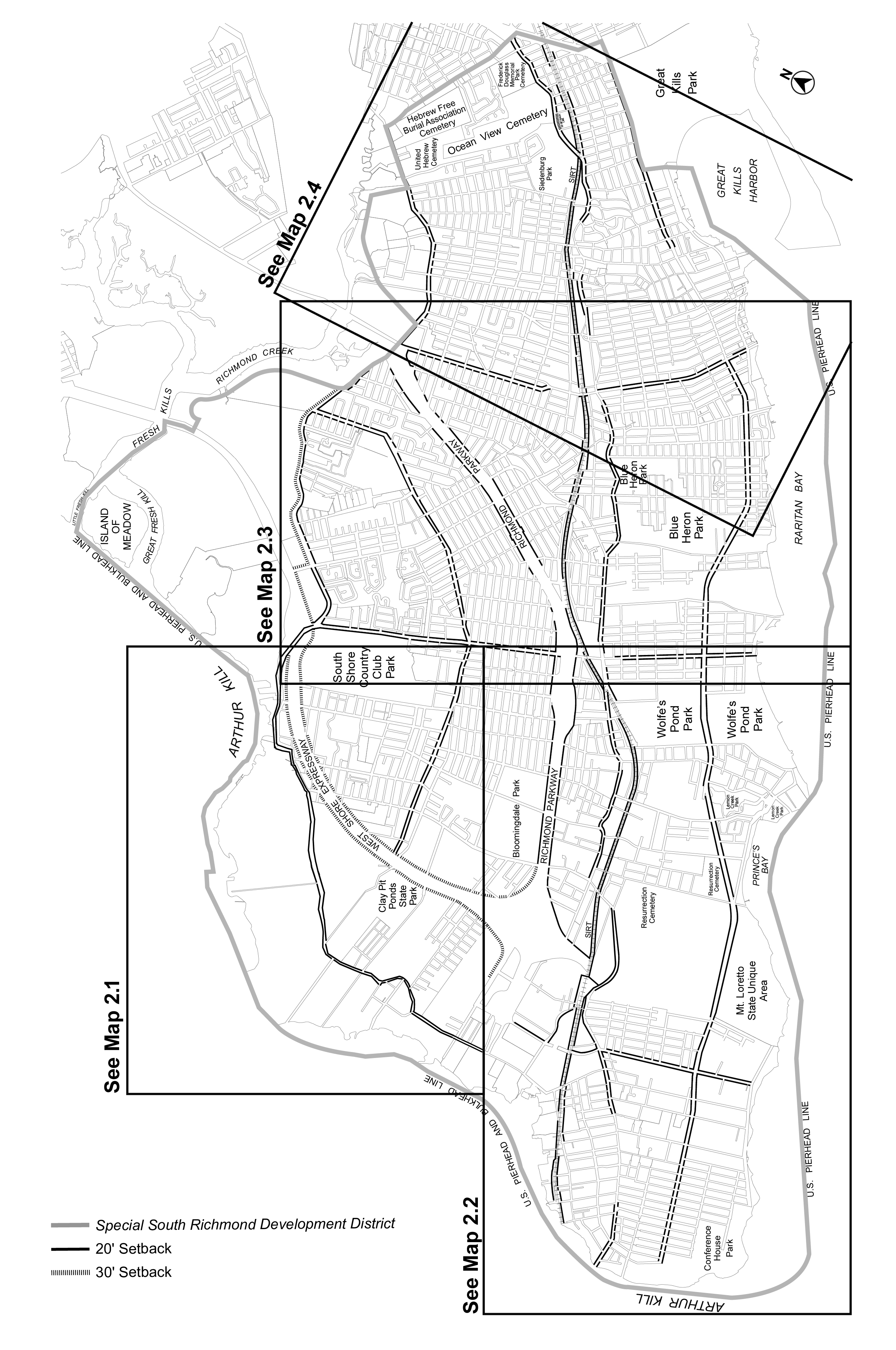
Map 2.1 — Arterial Setback Plan (11/2/23)
Map 2.2 — Arterial Setback Plan (11/2/23)
Map 2.3 — Arterial Setback Plan (11/2/23)
Map 2.4 — Arterial Setback Plan (11/2/23)
Map 3 — Open Space Network (11/2/23)
Map 3.1 — Open Space Network (11/2/23)
Map 3.2 — Open Space Network (11/2/23)
Map 3.3 — Open Space Network (11/2/23)
Map 3.4 — Open Space Network (11/2/23)
Map 3.5 — Open Space Network (11/2/23)
Map 3.6 — Open Space Network (11/2/23)
Map 4 — Special Areas LL, M and SH (11/2/23)