Chapter 5 - Special Natural Area District (NA)
GENERAL PURPOSES
The "Special Natural Area District" (hereinafter also referred to as the "Special District"), established in this Resolution, is designed to promote and protect public health, safety and general welfare. These general goals include, among others, the following specific purposes:
(a) to guide development in areas of outstanding natural beauty in order to protect, maintain and enhance the natural features of such areas;
(b) to preserve land having qualities of exceptional recreational or educational value to the public;
(c) to protect aquatic, biologic, botanic, geologic and topographic features having ecological and conservation values and functions;
(d) to reduce hillside erosion, landslides and excessive storm water runoff associated with development by conserving vegetation and protecting natural terrain;
(e) to preserve hillsides having unique aesthetic value to the public; and
(f) to promote the most desirable use of land and the direction of building development in accordance with a well-considered plan, to promote stability of residential development, to promote the character of the district and its peculiar suitability for particular uses, to conserve the value of land and buildings and thereby protect the City's tax revenues.
Definitions
Definitions specially applicable to this Chapter are set forth in this Section. The definitions of other defined terms are set forth in Section 12-10 (DEFINITIONS).
Area of no disturbance
An "area of no disturbance" is an area designated on the site plan that is protected from all types of intrusion, including: site alteration, operation of construction equipment, storage of construction materials, excavation or regrading, tunneling for utilities, removal of trees, topsoil or any living vegetation, or construction of driveways, private roads, parking areas, patios, decks, swimming pools, walkways or other impervious surfaces, including any surfaces with permeable paving. Areas of no disturbance shall include steep slopes, steep slope buffers and the critical root zone of each tree proposed for preservation.
Average percent of slope
The "average percent of slope" of a zoning lot is the average slope of all portions of a zoning lot excluding steep slopes and shall be determined according to the following equation:
|
S |
= |
IL |
x |
100 |
|
A |
Where: S - average percent of slope
I - contour interval in feet
L - combined length of contour lines in feet, excluding those portions bordering or lying within areas having a slope of 25 percent or greater and meeting the definition of steep slope
A - gross area in square feet of the zoning lot, excluding those portions of the zoning lot having a slope of 25 percent or greater and meeting the definition of steep slope. For a proposed site alteration on a tract of land not within a zoning lot, the portion of such tract of land owned by the applicant shall be considered to be part of the zoning lot
100 - factor which yields slope as a percentage
CALCULATING AREAS HAVING A SLOPE EQUAL TO OR GREATER THAN 25 PERCENT (ILLUSTRATIVE EXAMPLE)
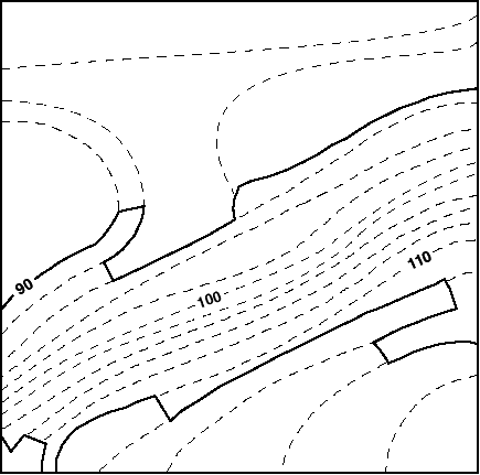
Example:
|
X |
= |
Contour interval in feet |
= |
2 |
= |
8.0 feet |
|
0.25 |
0.25 |
Where: X - distance between contour lines which indicates a slope of 25 percent
In order to calculate the area having a slope equal to or greater than 25 percent, one can use a map with two-foot contour intervals and a scale of one inch equals 20 feet, as shown in the map in this Section. A 25 percent slope, on a map with two-foot contour intervals, is indicated by contour lines that are 8.0 feet apart, rounded to the nearest tenth (0.1) of a foot. On a map whose scale is one inch to 20 feet, 8.0 feet is represented by 0.4 of an inch, rounded to the nearest tenth (0.1) of an inch. Identify where the contour lines are 0.4 of an inch or less apart. Connect these contour lines (as indicated by the heavy lines on the map) and calculate the area.
Caliper (of a tree)
"Caliper" of a tree is the diameter of a tree trunk measured 4 feet, 6 inches from the ground. If a tree splits into multiple trunks below 4 feet, 6 inches from the ground, the trunk is measured at its most narrow point beneath the split.
Critical root zone
The "critical root zone" of a tree is the area containing the roots of a tree that must be maintained and protected to ensure the tree's survival. The area of the critical root zone is measured as one radial foot for every caliper inch of the tree, with a required minimum of four radial feet and maximum of 22 radial feet, measured from the surface of the tree trunk at grade.
Hillside
A "hillside" is ground where the ratio of change in elevation to horizontal distance results in a 10 percent or greater slope or average percent of slope.
Natural feature
A "natural feature" is a specific natural feature belonging to one of the types listed in Section 105-10 (NATURAL FEATURES) and existing within a Special Natural Area District.
Site alteration
A "site alteration" is an alteration on any vacant tract of land, land with minor improvements or any tract of land containing buildings or other structures which includes land contour work, topographic modifications, removal of topsoil, vegetation, excavating, filling, dumping, changes in existing drainage systems, improvements in public rights-of-way, relocation of erratic boulders or modification of any other natural features, whether or not a permit is required from the Department of Buildings, the Department of Transportation or other public agencies.
Staging area
A "staging area" is any area on a zoning lot used during the construction of a development, enlargement or site alteration for the purposes of stockpiling soil or construction materials; storing, cleaning or servicing construction equipment, vehicles or tools; or storing leachable construction products, gases or other materials used to clean or service vehicles, equipment or tools.
Steep slope
A "steep slope" is a portion of a zoning lot with an incline of 25 percent or greater. However, a portion of a zoning lot with an incline of 25 percent or greater shall not be considered a steep slope if it occupies an area of less than 200 square feet or has a dimension of less than 10 feet, measured along the horizontal plane, unless such portions in the aggregate equal 10 percent or more of the area of the zoning lot.
Steep slope buffer
A "steep slope buffer" is a 15-foot wide area having a slope of less than 25 percent that adjoins the entire length of the crest of a steep slope.
Tier I site
A "Tier I site" is a zoning lot or other tract of land having an average percent of slope of less than 10 percent.
Tier II site
A "Tier II site" is a zoning lot or other tract of land having an average percent of slope equal to or greater than 10 percent.
Topsoil
"Topsoil" is soil containing undisturbed humus and organic matter capable of sustaining vigorous plant growth and is generally the top six inches of soil.
Tree credit
A "tree credit" is a credit for preserving an existing tree of six-inch caliper or more that is counted towards a tree preservation requirement or a credit for a newly planted tree of three-inch caliper or more that is counted towards a tree planting requirement.
Tree protection plan
A "tree protection plan" is a plan that modifies the area of no disturbance around a tree proposed for preservation while protecting and preserving the tree during construction. A tree protection plan is prepared by an arborist certified by the International Society of Arborculturists (ISA) or equivalent professional organization that includes:
(a) a survey of the current condition and health of such trees of six-inch caliper or more;
(b) methods for tree protection and preservation based on best management practices, including the prevention of damage due to compaction, grade and drainage pattern changes and tunneling for utilities;
(c) a schedule for site monitoring during construction;
(d) a procedure to communicate protection measures to contractor and workers; and
(e) post-construction treatment.
General Provisions
In harmony with the general purpose and intent of this Resolution and the general purposes of the Special Natural Area District, the regulations of the districts upon which this Special District is superimposed are supplemented or modified in accordance with the provisions of this Chapter, in order to protect outstanding natural features described herein. Except as modified by the express provisions of this Chapter, the regulations of the underlying district remain in effect.
The provisions of this Chapter shall apply to:
(a) any development, enlargement or site alteration;
(b) any subdivision of a zoning lot existing on the effective date of the Special District designation into two or more zoning lots; and
(c) any public improvement projects located within the Special Natural Area District, which shall be subject to the provisions of Sections 105-92 (Special Provisions for City-owned Land) and 105-93 (Inter-agency Coordination), except for any such projects which were approved by the Board of Estimate prior to the effective date of the Special District designation.
Prior to issuance by the Department of Buildings or other City or State agencies, of a permit for any development, enlargement or site alteration within a Special Natural Area District, or for any site alteration for which no permit is required by the Department of Buildings or other City or State agencies, an application shall be submitted to the City Planning Commission for review and approval pursuant to Section 105-40 (SPECIAL REVIEW PROVISIONS), except those developments, enlargements and site alterations that are not subject to the provisions of Section 105-40, as specified in Section 105-021 (Actions not requiring special review).
Any authorization or special permit granted by the City Planning Commission after July 18, 1995, pursuant to the provisions of this Chapter, may be started or continued, in accordance with the terms thereof, or as such terms may be subsequently modified, pursuant to the regulations in effect at the time such authorization or special permit was granted, subject to the provisions of Sections 11-42 (Lapse of Authorization or Special Permit Granted by the City Planning Commission Pursuant to the 1961 Zoning Resolution) and 11-43 (Renewal of Authorization or Special Permit).
When a zoning lot existing on the effective date of the Special District designation is subdivided into two or more zoning lots, an application shall be submitted to the Commission for review and approval pursuant to Section 105-90 (FUTURE SUBDIVISION).
For transit-adjacent sites, as defined in Section 66-11 (Definitions), in the event of a conflict between the provisions of this Chapter and the provisions of Article VI, Chapter 6 (Special Regulations Applying Around Mass Transit Stations), the provisions of Article VI, Chapter 6 shall control.
In flood zones, in the event of a conflict between the provisions of this Chapter and the provisions of Article VI, Chapter 4 (Special Regulations Applying in Flood Zones), the provisions of Article VI, Chapter 4, shall control.
The special review requirements of Section 105-40 (SPECIAL REVIEW PROVISIONS) of this Chapter shall not apply to the following:
(a) a site alteration on a zoning lot containing buildings or other structures, or a development or enlargement on any zoning lot, provided that such zoning lots shall have:
(1) not more than 10,000 square feet of lot area;
(2) an average percent of slope of less than 10 percent;
(3) no significant natural features, and the resulting development, enlargement or site alteration can satisfy the requirements of Section 105-30 (PRESERVATION OF NATURAL FEATURES), inclusive;
(4) the resulting development, enlargement or site alteration not exceed 2,500 square feet of lot coverage; and
(5) no Notice of Restriction or Restrictive Declaration recorded against the title of such property;
(b) any site alteration, on a zoning lot containing a residential building in existence on the effective date of the Special District designation, involving a structure that does not require a permit from the Department of Buildings, including, but not limited to swimming pools, garden sheds and fences, provided that:
(1) any modification of topography for the footprint, foundation or grading around the footprint of such structure shall not exceed two feet of cut or fill; and
(2) no tree of six-inch caliper or greater shall be removed and the critical root zone of such tree shall be an area of no disturbance on any zoning lot.
Requirements for application
An application to the City Planning Commission for certification, authorization or special permit and to the Department of Buildings respecting any development, enlargement or site alteration, to be made within any Special Natural Area District, shall include the following:
(a) a survey map prepared by a registered surveyor showing topography at two-foot contour intervals and indicating the average percent of slope, the existing slope of the land, as it occurs, in categories of 10–14 percent, 15–19 percent, 20–24 percent, 25 percent and greater; the location of existing buildings or other structures, patios, decks, swimming pools, walkways, driveways and private roads, including sidewalks and other impervious surfaces; and the location, caliper and species of all trees of six-inch caliper or more on the zoning lot and in the sidewalk area of the adjacent streets, location of geologic features, aquatic features and botanic environments, as en–umerated in Section 105-11 (Description of Natural Features);
(b) photographs showing the location and condition of such natural features for verification with pre-existing aerial survey and/or other photographs for each Special Natural Area District;
(c) a site plan prepared by a registered architect or professional engineer indicating the location of all existing buildings or other structures; the location of all proposed buildings or other structures; the location of existing and proposed patios, decks, swimming pools, walkways, driveways and private roads, including sidewalks and other impervious surfaces; the location of any steep slopes, steep slope buffer areas and the staging area; and the location, caliper and species of all trees of six-inch caliper or more on the zoning lot and in the sidewalk area of the adjacent streets. The site plan shall identify those trees proposed to be removed and those trees proposed to be preserved, indicating, for the latter, the critical root zone and in addition, for Tier II sites, the location of any other area of no disturbance;
(d) a drainage plan and soil report prepared by a professional engineer, when necessary to assess whether or not there will be major impact on natural features. The drainage plan shall describe the temporary (during construction) and permanent measures to collect, direct and discharge stormwater drainage from the site, indicating the direction of drainage flow and providing detailed plans and locations of all surface and subsurface drainage devices, walls, dams, sediment basins, stormwater storage (detention and retention) facilities, and other drainage facilities and protective devices. Such report shall include an estimate of runoff from the site after completion of any proposed development, enlargement or site alteration and provide a description with supporting information of the manner in which the proposed development, enlargement or site alteration complies with the requirements of Local Law 103 of 1989;
(e) a grading plan showing all existing and proposed contours at two-foot intervals, critical spot elevations, tops and bottoms of proposed slopes over 10 percent gradient and will indicate at least one longitudinal and one latitudinal cross-section showing both the original and proposed final ground surfaces, with grades, slopes and elevations noted;
(f) a landscaping and revegetation plan, prepared by a registered landscape architect, indicating the extent of vegetation and topsoil removal required for site preparation and development and the location and species of all new plantings;
(g) any other information necessary to evaluate the request; and
(h) for developments, enlargements and site alterations on Tier II sites, the application shall also include:
(1) an alignment and paving plan for any private road with a typical cross-section; and
(2) a construction plan prepared by a registered landscape architect, registered architect, licensed surveyor or professional engineer showing the proposed location for the staging area, the proposed method for protecting trees, understory shrubs and ground cover during construction, as well as a description of the equipment to be employed in processing and disposing of soil and other material to be removed from the site; and if the critical root zone is proposed to be modified, a tree protection plan for any tree proposed for preservation.
For a site alteration, enlargement or development within any Special Natural Area District, the Commission may modify one or more requirements set forth in paragraphs (a) through (h) of this Section, when such modification is requested by the applicant in writing and when the Commission determines that the requirements are unnecessary for evaluation purposes.
Appendix B of this Chapter should be used as a guide to assist in identifying the natural features on the survey required in this Section.
The applicant's submission shall also include a statement admitting authorized Department of City Planning personnel to the site for the purposes of recording or verifying survey data.
Where a permit is required for a development, enlargement or site alteration within a Special Natural Area District from any City or State agency, an application for such permit shall be filed simultaneously with such agency and the Commission.
In all cases, the City Planning Commission shall deny an application, whenever the development, enlargement or site alteration will interfere with a public improvement project (including highways, public buildings or facilities, redevelopment or renewal projects, or rights-of-way for sewers, transit or other public facilities) that has been approved by the City Council or the City Planning Commission.
District Plan
The regulations of this Chapter are designed to implement the Special Natural Area District Plan. The District Plan includes the following:
Appendix A - Special Natural Area District Plan Maps
Appendix B – Glossary
Appendix C - Selection List for Ground Covers and Shrubs
Appendix D - Tree Selection List for On-site Trees
Appendix E - Tree Selection List for Street Trees
These maps and lists are hereby incorporated and made part of this Resolution for the purpose of specifying locations where the special regulations and requirements set forth in this Chapter shall apply.
NATURAL FEATURES
All natural features shall be significant in terms of age, size, composition, function, structure, history, association, location, ecological value or educational interest.
The protection of one natural feature may require the protection of another which is closely linked to it. The preservation of natural features may also be necessary to avoid such adverse conditions as flooding, erosion or hazards to private property. All vegetation is part of a botanic environment or part of an aquatic feature and shall be considered as a natural feature protected by the regulations of this District. For the purposes of this Chapter, vegetation includes all forms of plant material, including, but not limited to, trees, shrubs, vines, ferns, grasses, herbs and other plant life.
All natural features defined in this Section and further described in Appendix B of this Chapter shall be protected by the provisions of this Chapter.
(a) Geologic features
(1) Rock outcrop
A rock outcrop is the portion of a rock formation which appears at the surface of the earth.
(2) Geologic deposit
A geologic deposit is a mass of material which has been placed, shaped or created by the actions of wind, water, ice, gravity, vulcanism, pressure or temperature, either alone or in combination. Such deposits are to include erratic boulders, glacial formations, mineral deposits or semi-precious stones.
(b) Topographic features
(1) Steep slope
(2) Existing natural topography
Existing natural topography is the ground elevation of land.
(3) Topsoil
Topsoil is generally the top six inches of soil containing undisturbed humus and organic matter capable of sustaining vigorous plant growth.
(c) Aquatic features
Wetlands, including, but not limited to State and Federal, mapped or designated, freshwater or tidal wetlands:
(1) Laminarian zone
A laminarian zone is that land under the surface of salt water from the mean low tide mark to the depth of 15 fathoms. The portion of laminarian zone to be protected by the provisions of this Special District extends to the pierhead line or to the shore line where no pierhead line has been established.
(2) Beach
A beach is a tract of relatively flat, sandy or gravelly land, without visible vegetation, forming the shore of a large body of water.
(3) Tidal wetland and saltwater littoral zone
A tidal wetland or saltwater littoral zone is that land which is regularly covered by tidal waters and its spray.
(4) Swamp
A swamp is a wet woodland, the soil of which is typically waterlogged or often covered with water.
(5) Marsh
A marsh is a wet prairie that has waterlogged soil during the growing season (from last spring frost to first fall frost) and is often covered with shallow water.
(6) Bog
A bog is a tract of waterlogged land without natural drainage.
(7) Meadow
A meadow is a tract of land that is waterlogged to within a few inches of the surface and may have temporary ponds during the non-growing season (between the first fall frost and first spring frost).
(8) Creek, stream or brook
A creek, stream or brook is a free flowing fresh watercourse on soil, gravel or rock that drains a watershed.
(9) Lake or pond
A lake or pond is a body of fresh or salt water standing year round.
(10) Natural spring
A natural spring is a point source of water exiting from the surface of the earth or rock.
(d) Botanic environments
(1) Primary succession community area
A primary succession community area is a tract of land characterized by species that can tolerate extreme environmental conditions and provide initial protection for less tolerant forms of life. These species are usually annuals and herbaceous.
(2) Secondary succession community area
A secondary succession community area is a tract of land characterized by short-lived trees and shrubs as well as grasses and herbaceous material. These species are less tolerant than primary succession community species but provide a greater diversity and range of protection from the sun, wind and rain.
(3) Climax community area
A climax community area is a stable association of plants and animals that will perpetuate itself indefinitely with minor variation in the group of associated plants. The climax community area in New York City is the glaciated oak-chestnut association, which is part of the eastern hardwood deciduous forest.
(4) Dune or heathland
A dune or heathland is a tract of windblown and wind- or water-shaped sandy land with such characteristic species as beach grass and beach heather.
(5) Wild grassland
A wild grassland is an area whose vegetation is primarily of wild grass species.
The natural features defined in this Section are described in Appendix B of this Chapter.
All natural features within a Special Natural Area District shall be protected by the regulations of this Chapter in accordance with the provisions set forth in Sections 105-02 (General Provisions), 105-30 (PRESERVATION OF NATURAL FEATURES) and 105-50 (REGULATIONS FOR PROTECTION OF NATURAL FEATURES).
Except for any existing natural feature that is unsafe and the removal of which is required by the Department of Buildings to eliminate hazardous conditions, no natural features described in Section 105-11 (Description of Natural Features) shall be removed, destroyed or altered unless permitted by certification, authorization or special permit of the City Planning Commission, pursuant to Section 105-40 (SPECIAL REVIEW PROVISIONS), or allowed pursuant to Section 105-021 (Actions not requiring special review).
The provisions of this Section are applicable to all developments, enlargements and site alterations within the Special Natural Area District, pursuant to Section 105-02 (General Provisions). When pursuant to Sections 105-41 (Certification) or 105-021 (Actions not requiring special review), it is not necessary for an applicant for a development, enlargement or a site alteration to apply for an authorization or special permit, such development, enlargement or site alteration shall nonetheless comply with the natural feature preservation requirements of this Section, inclusive.
To the maximum extent possible, existing trees and vegetation shall be retained. Trees of six-inch caliper or more and vegetation may only be removed or destroyed as a result of a development, enlargement or site alteration, provided that:
(a) such trees or vegetation are located in areas to be occupied by buildings, private roads, driveways, areas for required accessory parking, or within a distance of 15 feet of the exterior walls of such building, provided that it is not possible to avoid such removal by adjustments in the arrangement of such buildings, driveways or required parking areas;
(b) the continued presence of such tree would create special hazards or dangers to persons or property, which would not be possible or practical to eliminate by pruning;
(c) the continued presence of such tree would interfere with the growth or health of another tree of six-inch caliper or more, designated for preservation and belonging to a species listed in Appendix D (Tree Selection List for On-site Trees) of this Chapter; or
(d) an authorization pursuant to Section 105-425 (Modification of botanic environment and tree preservation and planting requirements) has been granted by the City Planning Commission approving the removal of such trees or vegetation.
Any tree of six-inch caliper or more that cannot be preserved as a result of a proposed development, enlargement or site alteration shall be replaced pursuant to the provisions of Section 105-32 (Botanic Environment and Tree Planting Requirements).
Any vegetation that cannot be saved as a result of site alteration, enlargement or development shall be replaced with alternative vegetation to be approved by the City Planning Commission. All developments, enlargements and site alterations shall comply with the tree planting requirements set forth in this Section, whether or not existing trees are removed as a result of such development, enlargement or site alteration.
The replanting of elements of vegetation that are parts of an association or community shall be such as to reestablish, as rapidly as is reasonable, the vigor and character of the association. When necessary to establish ecological balance, the Commission may also require additional vegetation to be planted.
(a) Tree planting
For the purposes of this Section, the following minimum standard shall apply for tree planting:
(1) For any development, enlargement or site alteration within a Special Natural Area District, trees of at least three-inch caliper, pre-existing or newly planted, shall be provided on the zoning lot at the rate of one tree for each 1,000 square feet of lot area or portion thereof or shall equal a total of 51 percent of all tree credits for trees originally on site, whichever is greater.
(2) For any existing tree of at least six-inch caliper that is preserved, credit for one tree shall be given for the first six inches of caliper and, for each additional four inches of caliper, credit for an additional tree shall be given.
Single-trunk trees, newly planted to meet this requirement, shall be of at least three-inch caliper at the time of planting. Multiple-trunk trees and low-branching coniferous evergreens shall be at least 10 feet in height at the time of planting. Trees newly planted to meet this requirement shall be of a species selected from Appendix D of this Chapter, and acceptable from the standpoint of hardiness, appearance and habit of growth suitable to the site.
The Commission may grant a waiver of the tree planting requirements by certification to the Department of Buildings, where the Commission finds that the ecology of the site is such that the substitution of other plant material would be more appropriate than the tree planting requirements and a detailed plan for planting has been filed with the Commission for its approval.
(b) Botanic Environment Planting
For the purposes of this Section, the following minimum standard shall apply for the planting of vegetation.
Any vegetation or topsoil that cannot be preserved as a result of a proposed development, enlargement or site alteration and is not permitted to be removed pursuant to the regulations of Sections 105-31 (Botanic Environment and Tree Preservation Requirements) or 105-425 (Modification of botanic environment and tree preservation and planting requirements), shall be replaced as follows: for every square foot of lot area of removed vegetation or topsoil, plantings shall be provided of the size and number indicated in paragraphs (b)(1), (b)(2), (b)(3) and (b)(4) of this Section. The area of removed vegetation shall be measured so as to include any portions of the zoning lot that were located within the critical root zone of a removed tree of six-inch caliper or more. Species of ground cover and shrubs shall be selected from Appendix C (Selection List for Ground Covers and Shrubs) of this Chapter. Species of on-site trees shall be selected from Appendix D (Tree Selection List for On-site Trees) of this Chapter.
(1) Ground cover shall be planted one at one-foot-on-center and at the rate of one plant for every square foot of lot area of removed vegetation; and
(2) Large trees shall be planted at the rate of one three-inch caliper tree for every 500 square feet of lot area of removed vegetation; or
(3) Small trees shall be planted at a rate of one eight-foot high tree for every 100 square feet of lot area of removed vegetation; or
(4) Shrubs shall be planted at a rate of one gallon container-grown material for every 25 square feet of lot area of removed vegetation.
The planting of species shall not be limited to woody plant materials, but shall include trees, shrubs, vines, ferns, grasses, herbs, annuals, biennials, perennials, mosses and other associated vegetation. All vegetation to be planted shall be either of the species which characterized the area's biological community prior to site alteration, enlargement or development, or of an alternative biologic community found in the area. Species selection shall give particular attention to the relationship of the species to each other and to the surrounding plant community and to the quality of the soil and the vertebrate and invertebrate populations associated with and dependent upon the proposed plants.
The maximum permitted percentage of lot coverage for residences on a zoning lot shall be determined by Table I or Table II of this Section, as applicable.
TABLE I
PERMITTED PERCENTAGE OF LOT COVERAGE ON A TIER II ZONING LOT BY ZONING DISTRICT, AVERAGE PERCENT OF SLOPE AND RESIDENCE TYPE
|
Residence District* |
|||||||
|
R6 |
|||||||
|
Average Percent of Slope |
R1 |
R2 |
R3 |
R4 |
R5 |
1-2 Family |
Other |
|
10–14.9 |
22.5 |
22.5 |
22.5 |
36.0 |
45.0 |
48.6 |
32.4 |
|
15–19.9 |
20.0 |
20.0 |
20.0 |
32.0 |
40.0 |
43.2 |
28.8 |
|
20–24.9 |
17.5 |
17.5 |
17.5 |
28.0 |
35.0 |
37.8 |
25.2 |
* or Residence District equivalent when zoning lot is located within a Commercial District
If an authorization is granted for a development, enlargement or site alteration on a portion of a zoning lot having a steep slope or steep slope buffer pursuant to Section 105-422 (Authorization of a development, enlargement or site alteration on a Tier II site or portion of a zoning lot having a steep slope or steep slope buffer), the maximum permitted percentage of lot coverage for such zoning lot shall not exceed the maximum set forth in Table II of this Section.
TABLE II
PERMITTED PERCENTAGE OF LOT COVERAGE ON ANY ZONING LOT GRANTED AN AUTHORIZATION PURSUANT TO SECTION 105-422 FOR MODIFICATION OF A STEEP SLOPE OR STEEP SLOPE BUFFER
|
Residence District* |
||||||
|
R6 |
||||||
|
R1 |
R2 |
R3 |
R4 |
R5 |
1-2 Family |
Other |
|
12.5 |
12.5 |
12.5 |
20.0 |
25.0 |
27.0 |
18.0 |
* or Residence District equivalent when zoning lot is located within a Commercial District
With the exception of private roads and driveways, no grading shall take place beyond 15 feet of the location of a building foundation, measured from the foundation perimeter. The following grading requirements shall apply to all Tier II sites.
(a) Cut slopes shall be no steeper than two horizontal to one vertical; subsurface drainage shall be provided as necessary for stability.
(b) Fill slopes shall be no steeper than two horizontal to one vertical; fill slopes shall not be located on natural slopes 2:1 or steeper, or where fill slope toes out within 12 feet horizontally of the top of an existing or planned cut slope.
(c) Excavating for fill shall be prohibited unless the material is obtained from a cut permitted under an approved grading plan obtained for some purpose other than to produce fill material, or imported from outside the Special Natural Area District.
(d) Fills shall be compacted to at least 95 percent of maximum density, as determined by AASHTO T99 or ASTM D698.
(e) All retaining walls or cuts with a total vertical projection in excess of three feet and associated with cut or fill surfaces shall be designed as structural members keyed into stable foundations and capable of sustaining the design loads.
(f) The top and toe of any cut or fill slope, or where any excavation meets the grade existing on February 2, 2005, should be rounded in a vertical arc with a radius of not less than five feet.
(g) Tops and toes of cut and fill slopes and retaining walls shall be set back from lot lines for a horizontal distance of three feet plus one-fifth the height of the cut or fill but need not exceed a horizontal distance of 10 feet; tops and toes of cut and fill slopes shall be set back from buildings and structures for a horizontal distance of six feet plus one-fifth the height of the cut or fill but need not exceed a horizontal distance of 10 feet.
The provisions set forth in this Section and Section 105-34 (Grading Controls for Tier II Sites) shall apply to driveways and to private roads that provide access to buildings developed after February 2, 2005. The provisions for private roads set forth in Article II, Chapter 6, shall not apply.
(a) Driveways
(1) The maximum grade of a driveway shall not exceed 10 percent.
(2) The paved width of a driveway shall not exceed 18 feet.
(3) The maximum length of a driveway from a private road or street to an accessory parking space shall not exceed 80 feet.
(b) Private roads
(1) The maximum grade of a private road shall not exceed 10 percent.
(2) The width of the graded section beyond the curb back or edge of pavement of a private road shall extend no more than three feet beyond the curb back or edge of pavement on both the cut and the fill sides of the roadway. If a sidewalk is to be installed parallel to the roadway, the graded section shall be increased by the width of the sidewalk plus no more than one foot beyond the curb back.
(3) The paved width of a private road shall not exceed 34 feet.
(4) Curbs shall be provided along each side of the entire length of a private road and accessory parking spaces may be located between the required roadbed and curb.
(5) A curb cut, excluding splays, from a street to a private road may be as wide as such private road.
(6) Curb cuts providing access from private roads to parking spaces shall not exceed the width of the driveway served and in no event shall exceed a width of 18 feet, including splays.
(7) A minimum distance of 16 feet of uninterrupted curb space shall be maintained between all curb cuts.
(8) Along the entire length of a private road, trees shall be provided and maintained at the rate of one tree for every 25 feet of private road frontage and shall comply with the requirements set forth in Section 105-32 (Botanic Environment and Tree Planting Requirements).
(9) No building permit shall be issued by the Department of Buildings without approval by the Fire Department regarding the adequacy of vehicular access to and within the development for fire safety. Such approval may include the modification of private road width as set forth in paragraph (b)(3) of this Section.
The City Planning Commission may by authorization pursuant to Section 105-434 (Modification of requirements for private roads and driveways), allow modifications to, or waivers of, the requirements of this Section. The prior approval of the Fire Department regarding the adequacy of vehicular access to and within the development for fire safety shall be a condition for any modification or waiver.
Controls During Construction
The following requirements must be met during construction and identified on the construction plan:
(a) No construction equipment of any kind shall operate beyond 15 feet of the perimeter of a building foundation except those vehicles engaged in the construction of private roads, driveways or required accessory parking areas. This provision may be waived by the Commissioner of Buildings should it be determined that the particular conditions of the site make a 15-foot limit infeasible or impractical.
(b) Construction fences shall be erected around all vegetation proposed for preservation and all areas of no disturbance, and those portions of the fence that are downhill from the construction site shall have hay bales placed adjacent to them.
(c) Excavating for fill shall be prohibited unless the material is obtained from a cut permitted under an approved grading plan obtained for some purpose other than to produce fill material, or imported from outside the Special Natural Area District.
(d) The staging area shall be located in an area that would most minimize destruction of the natural features of the landscape. Such area shall be as close to the construction area on the zoning lot as practical, and shall be either on the flattest portion of the zoning lot or behind a containment wall where it will not erode any area of no disturbance or endanger any tree designated for preservation.
(e) Topsoil shall be used in the area to be replanted as soon as construction is complete.
(f) Any exposed earth area shall have straw, jute matting or geotextiles placed on it within two days of exposure and be seeded with annual rye grass during construction.
Any development, enlargement or site alteration that is on a Tier II site and requires an authorization shall be subject to the provisions of this Section. The requirements of this Section shall supplement any other requirements set forth in Section 105-40 (SPECIAL REVIEW PROVISIONS) that also must be met.
Prior to construction, at least one of the erosion and sedimentation control measures described in paragraphs (a) through (e) of this Section shall be selected. A plan describing how the selected erosion and sedimentation control measure will be implemented and justifying its selection on the basis of the particular conditions of the site shall be prepared by a professional engineer or landscape architect and submitted to the City Planning Commission.
(a) Benches and berms
These are level terraces or ledges constructed across sloping land to provide a relatively flat construction site or reduce the length and grade of the slope. Benches and berms reduce runoff and erosion hazards by slowing down the velocity of water and providing greater intake opportunity.
(b) Diversion channels
These are earth channels with a supporting ridge on the lower side constructed across the slope lengths to break up concentration of runoff and move water to stable outlets at a non-erosive velocity.
(c) Debris or sediment basins
These consist of a dam or embankment, a pipe outlet and an emergency spillway situated at the low corner of the site to provide a temporary means of trapping and storing sediment while releasing the water. They protect property below the installation from damage by excessive sedimentation and debris.
(d) Retention ponds
These are impoundment-type ponds that temporarily store runoff water and release it at rates that minimize erosion and prevent flooding. They may be located above the site to trap water before it enters the area or within the site to protect properties below the site.
(e) Grassed waterways or outlets
These are natural or excavated channels to dispose of excess runoff water from diversions, berms, benches and other areas at non-erosive velocities. Waterways or outlets are shaped or graded and established in suitable vegetation as needed, depending on the supplemental measure used to slow the velocity of runoff.
When a development, enlargement or site alteration is on a Tier II site, an application to the City Planning Commission for an authorization shall include the following submission requirements. These requirements shall be in addition to the requirements set forth in Section 105-40 (SPECIAL REVIEW PROVISIONS).
(a) A drainage plan and soil report prepared by a professional engineer to protect natural features. The drainage plan shall describe the temporary (during construction) and permanent measures to collect, direct and discharge stormwater drainage from the site, indicating the direction of drainage flow and providing detailed plans and locations of all surface and subsurface drainage devices, walls, dams, sediment basins, stormwater storage (detention and retention) facilities, and other drainage facilities and protective devices. Such report shall include an estimate of runoff from the site after completion of proposed developments, enlargements or site alterations and provide a description with supporting information of the manner in which the proposed development, enlargement or site alteration complies with the requirements of Local Law 103 of 1989.
(b) An erosion and sedimentation plan as described in Section 105-37 (Special Erosion and Sedimentation Prevention Requirements for Authorizations for Tier II Sites).
(c) For any development or site alteration on a tract of land 40,000 square feet or greater, a landscape plan prepared by a registered landscape architect that shows the location and species of all new plantings of trees, shrubs and ground covers and the proposed method of preserving existing trees, shrubs and ground covers.
(d) Any other information the Commission may deem necessary to evaluate the request.
The applicant's submission shall also include a statement admitting authorized Department of City Planning personnel to the site for the purposes of recording or verifying survey data.
SPECIAL REVIEW PROVISIONS
The provisions of this Section shall apply to all developments, enlargements or site alterations located within a Special Natural Area District.
Prior to the issuance by the Department of Buildings of any permit for a development, enlargement or site alteration within a Special Natural Area District, the City Planning Commission shall certify to the Department of Buildings that the development, enlargement or site alteration is approved pursuant to Sections 105-41 (Certification), 105-42 (Authorizations to Alter Natural Features), 105-43 (Authorizations to Modify Bulk, Parking, Grading and Private Roads Regulations) or 105-44 (Special Permit), inclusive.
The provisions of Article VII, Chapter 8 (Special Regulations Applying to Large-scale Residential Developments), shall apply to a large-scale residential development, as modified by the provisions of Section 105-701 (Applicability of large-scale residential development regulations).
Certification
When it is not necessary for the applicant for a development, enlargement or site alteration to apply for an authorization or special permit, the Chair of the City Planning Commission shall certify to the Department of Buildings that such development, enlargement or site alteration complies with the regulations of this Chapter, and that no authorization or special permit is required pursuant to this Chapter.
Where natural features are to be protected and maintained under Section 105-60 (MAINTENANCE OF NATURAL FEATURES), the Commission shall indicate in the certification specific conditions and safeguards appropriate to the designated area.
For a development, enlargement or site alteration located within the Special Natural Area District, the City Planning Commission may authorize:
(a) modification of topographic features including existing natural topography and topsoil pursuant to Section 105-421 (Modification of topographic features on Tier I sites) and modification of steep slopes pursuant to Section 105-422 (Authorization of a development, enlargement or site alteration on a Tier II site or portion of a zoning lot having a steep slope or steep slope buffer);
(b) modification of geologic features including the relocation of erratic boulders, and the alteration of rock outcrops pursuant to Sections 105-423 and 105-424;
(c) modification of botanic environment, pursuant to Section 105-425;
(d) alteration of aquatic features, pursuant to Section 105-426 in NA-1, NA-2 and NA-3 Districts.
The Commission may prescribe appropriate additional conditions and safeguards to protect the character of the Special Natural Area District.
The topographic features, including natural topography and topsoil, existing at the time of designation of a Special Natural Area District may be modified by the City Planning Commission, provided that the Commission finds that:
(a) development, enlargement and site alteration is not feasible without such modification, or that the requested modification will permit a development, enlargement or site alteration that satisfies the purposes of this Chapter;
(b) such modification, including any removal of topsoil, will not disturb the drainage pattern and soil conditions in the area;
(c) such modification of topography has minimal impact on the existing topographic features of the surrounding area and blends harmoniously with it;
(d) such modification is the least modification required to achieve the purpose for which it is granted; and
(e) the development, enlargement or site alteration takes advantage of the natural characteristics of the site.
Where permits are required from a City agency, the Commission shall request a report from such agency, and the provisions of Section 105-93 (Inter-agency Coordination) shall apply.
The City Planning Commission may authorize developments, enlargements and site alterations on a Tier II site or on portions of a zoning lot having a steep slope or steep slope buffer.
In order to grant such authorizations, the Commission shall find that:
(a) the development, enlargement or site alteration is not feasible without such modification, or that the modification will permit a development, enlargement or site alteration that satisfies the purposes of this Chapter;
(b) such modification is the least modification required to achieve the purpose for which it is granted;
(c) the modification has minimal impact on the existing natural topography and vegetation and blends harmoniously with it;
(d) the modification will not disturb the drainage patterns and soil conditions of the area; and
(e) the development, enlargement or site alteration takes advantage of the natural characteristics of the site.
The lot coverage regulations of Section 105-33 (Residential Lot Coverage Regulations on Sites Granted an Authorization Pursuant to Section 105-422) shall apply to any residential development, enlargement or site alteration granted an authorization pursuant to this Section.
Any development, enlargement or site alteration requiring an authorization pursuant to this Section shall be subject to all the requirements of this Chapter for which an authorization or special permit has not been obtained.
Relocation of erratic boulders
No erratic boulder with a diameter at any point of six feet or more may be moved from its location at the time of designation of a Special Natural Area District to another location within the Special District during development, enlargement or site alteration except in compliance with the provisions of this Section.
Prior to the moving of an erratic boulder from its present location to a location elsewhere within the Special Natural Area District, an application shall be filed with the City Planning Commission showing the present location and the proposed location. Moving of an erratic boulder will be permitted only by authorization of the Commission under the following circumstances:
(a) where such a boulder is located in an area to be occupied by buildings, driveways, parking areas or recreation areas and it is not possible to avoid such location by minor adjustments in the arrangement of such buildings, driveways, parking areas or recreation areas on the site;
(b) where the boulder's continued existence in its present location would create hazards or dangers; or
(c) where authorizations granted by the Commission under the provisions of this Chapter require or clearly contemplate the boulder's relocation from its present position.
In issuing an authorization under this Section, the Commission shall require an appropriate relocation site, visible, if possible, from a public street, park, or public place, preferably on the zoning lot or elsewhere within the Special Natural Area District. The Commission may prescribe appropriate conditions to enhance the setting of the relocated boulder.
Alteration of rock outcrops
The City Planning Commission may authorize the alteration of a rock outcrop, provided that:
(a) the development or enlargement is not feasible without such alteration, or that the requested alteration will permit a development or enlargement that satisfies the purposes of this Chapter; or
(b) such alteration is necessary to protect the health and safety of the site occupants; and
(c) such development or enlargement, as authorized, will result in the minimum natural feature interference that must be permitted in order to allow reasonable development or enlargement and bulk distribution under the regulations of the underlying district.
The Commission shall impose appropriate conditions and safeguards to assure protection of the portions of the area to be preserved in their natural state.
The City Planning Commission may authorize modifications to the provisions of Sections 105-31 (Botanic Environment and Tree Preservation Requirements), 105-32 (Botanic Environment and Tree Planting Requirements) and paragraph (b)(8) of Section 105-35 (Tier II Requirements for Driveways and Private Roads).
In order to grant such authorizations, the Commission shall find that:
(a) the development, enlargement or site alteration is not feasible without such modifications, or that the requested modification will permit a development, enlargement or site alteration that satisfies the purposes of this Chapter;
(b) such modification is the least modification required to achieve the purpose for which it is granted;
(c) the ecology and soil conditions of the site are such that the substitution of other plant material would be as appropriate as the botanic preservation or planting requirements being modified; and
(d) in order to modify requirements relating to tree preservation, planting or removal, the Commission shall also find that:
(1) such tree is located in areas which require excessive cut or fill of land deemed inimical to plant survival; or
(2) the continued presence of such tree would create hazards or dangers (such as an area affected by storm or plant disease) to persons, property or other plant material which it would not be possible or practical to eliminate by pruning.
Where on-site replanting of vegetation would result in overcrowding or would adversely affect the ecology of the site, the Commission may authorize planting of one or more trees on adjoining public sidewalks or in a nearby public area within the Special Natural Area District. The Commission may also allow the substitution of other plant material, provided a detailed landscaping plan is filed with the Commission for approval and certification.
Alteration of aquatic features
No portion of an aquatic feature shall be altered or land operations affecting aquatic features undertaken by or on behalf of present or future applicants for permits except in compliance with the provisions of this Section. The City Planning Commission may permit the alteration of aquatic features, provided that:
(a) the development or enlargement is not feasible without such alteration or where such alteration will permit a development or enlargement that satisfies the purposes of this Chapter; or
(b) such alteration is necessary to protect the health and safety of the site occupants; and
(c) such development or enlargement, as authorized, will result in the minimum natural feature interference that must be permitted in order to allow reasonable development or enlargement and bulk distribution under the regulations of the underlying district; and
(d) such modification shall not disturb the drainage patterns in the area.
The Commission shall impose appropriate conditions and safeguards to assure protection of the portions of the area to be preserved in their natural state.
Where permits are required from a City agency for any work affecting natural features, the Commission shall request a report from such agency and the provisions of Section 105-93 (Inter-agency Coordination) shall apply.
In the event alteration of an aquatic feature is found inappropriate, the Commission may treat an application under this Section as an application for modification of yard and height and setback regulations under Section 105-432.
For a development, enlargement or site alteration located within the Special Natural Area District, the City Planning Commission may authorize:
(a) modification of lot coverage controls in accordance with the provisions of Section 105-431;
(b) modification of underlying district regulations relating to bulk or parking in accordance with the provisions of Section 105-432 (Modification of yard, height and setback regulations, and parking location regulations);
(c) modification of grading controls in accordance with the provisions of Section 105-433; and
(d) modification of requirements for driveways and private roads on Tier I sites and Tier II sites in accordance with the provisions of Section 105-434.
For any development or enlargement on a Tier II site or within a steep slope or a steep slope buffer on a Tier I site, the City Planning Commission may authorize variations in the lot coverage controls set forth in Section 105-33.
In order to grant such authorization, the Commission shall find that:
(a) the development or enlargement is not feasible without such modification, or that the requested modification will permit a development or enlargement that satisfies the purpose of this Chapter;
(b) by allowing the permitted floor area in a building or buildings of lower height to cover more land, the preservation of hillsides having aesthetic value to the public would be assured, and that such preservation would not be possible by careful siting of a higher building containing the same permitted floor area on less land;
(c) such modification is the least modification required to achieve the purpose for which it is granted;
(d) the modification has minimal impact on the existing natural topography and vegetation and blends harmoniously with it;
(e) the modification will not disturb the drainage pattern and soil conditions of the area; and
(f) the modification does not impair the essential character of the surrounding area.
For any development or enlargement that does not qualify under provisions of Section 105-701 (Applicability of large-scale residential development regulations), the City Planning Commission may authorize variations in required front, rear or side yards, parking lot landscaping or maneuverability requirements, location of parking, driveways or curb cuts and required space between buildings on the same zoning lot, and may modify height and setback regulations for the purpose of preserving natural features, provided the Commission finds that:
(a) the proposed placement of buildings and arrangement of open space will not have significant adverse effects upon the light, air and privacy for existing buildings in adjacent areas or the opportunities therefore in future development; and
(b) will preserve significant natural features.
The Commission may condition such authorizations upon the joint submission of acceptable plans for development or enlargement of two or more adjacent zoning lots by the owners thereof.
Modification of grading controls
For any development, enlargement or site alteration on a Tier II site, the City Planning Commission may authorize variations in the grading controls set forth in Section 105-34.
In order to grant such authorization, the Commission shall find that:
(a) the development, enlargement or site alteration is not feasible without such modifications, or that the modifications will permit a development, enlargement or site alteration that satisfies the purposes of this Chapter;
(b) such modification is the least modification required to achieve the purpose for which it is granted;
(c) the modification has minimal impact on the existing natural topography and vegetation and blends harmoniously with it;
(d) the modification will not disturb the drainage pattern and soil conditions of the area;
(e) the modification does not impair the essential character of the surrounding area; and
(f) the benefits to the surrounding area from the modification outweigh any disadvantages that may be incurred thereby in the area.
For any development, enlargement or site alteration:
(a) the City Planning Commission may authorize variations in the requirements for private roads and driveways on any Tier II site as set forth in Section 105-35 (Tier II Site Requirements for Driveways and Private Roads), as well as the requirements of Sections 25-621 (Location of parking spaces in certain districts) and 25-631 (Location and width of curb cuts in certain districts) provided that:
(1) the development or enlargement is not feasible without such modification, or that the requested modification will permit a development, enlargement or site alteration that satisfies the purposes of this Chapter;
(2) such modification is the least modification required to achieve the purpose for which it is granted;
(3) the modification will not disturb the drainage pattern and soil conditions of the area;
(4) the modification has minimal impact on the existing natural topography and vegetation and blends harmoniously with it; and
(5) such modification will enhance the quality of the design of the development, enlargement or site alteration; or
(b) located on a zoning lot containing historic buildings designated by the Landmarks Preservation Commission within the New York City Farm Colony-Seaview Hospital Historic District, as shown on Map 2 in Appendix A of this Chapter, the City Planning Commission may authorize modifications or waivers of the requirements for private roads as set forth in Section 26-20 (SPECIAL REQUIREMENTS FOR LOTS WITH PRIVATE ROADS) through Section 26-27 (Waiver of Bulk Regulations Within Unimproved Streets), inclusive, and Section 26-30 (SPECIAL REQUIREMENTS FOR LOTS WITH PRIVATE ROADS IN LOWER DENSITY GROWTH MANAGEMENT AREAS) through 26-33 (Screening), inclusive, provided that such modification or waiver:
(1) results in greater environmental conservation or preservation of existing natural features;
(2) results in a superior site and landscape plan that will not unduly disturb the drainage pattern and soil conditions of the area;
(3) results in greater preservation of historic buildings or other architectural elements of the Historic District designated by the Landmarks Preservation Commission;
(4) enhances vehicular and pedestrian connections between buildings on the site and the surrounding neighborhood;
(5) will not impair the essential character of the Historic District and the surrounding area;
(6) is the least required to achieve the purpose for which it is granted; and
(7) will not reduce the required minimum width of the private road to a width less than 34 feet unless the Fire Department has approved such reduction and determined that emergency vehicles can adequately access and move within the site.
Special Permit
For any development, enlargement or site alteration within the Special Natural Area District, the City Planning Commission may grant special permits for modification of the underlying district regulations in accordance with the provisions of Sections 105-441 and 105-442.
Modification of use regulations
In addition to any use modifications which may be granted under the provisions of Section 105-701 (Applicability of large-scale residential development regulations), the City Planning Commission may permit semi-detached or attached single-family residences in R2 Districts and attached single- or two-family residences in R3-1 Districts.
Furthermore, except in the Special Natural Area District-1 (NA-1), the Commission may permit semi-detached or attached single-family residences in R1-2 Districts provided that the development or enlargement is on a tract of land of at least four acres, and provided the Commission finds that:
(a) the preservation of natural features requires the permitted development to be concentrated to the extent feasible in the remaining portion of the tract;
(b) for such concentration of development, better standards of privacy and usable open space can be and are achieved under the development plan by inclusion of the proposed residential building types;
(c) the change of housing type constitutes the most effective method of preserving natural features;
(d) the aggregate width of street walls of a number of residential buildings separated by party walls shall not exceed 100 feet;
(e) the proposed street system for the tract of land to be developed is so located as to draw a minimum of vehicular traffic to and through streets in the adjacent area; and
(f) the existing topography, vegetation and proposed planting effectively screen all attached single-family residences from the lot lines along the perimeter of the tract of land to be developed.
Where commonly or separately owned areas containing natural features of exceptional recreational, cultural or educational value to the public are dedicated to the City, without any cost to the City, pursuant to Section 105-701 (Applicability of large-scale residential development regulations), the City Planning Commission may by special permit allow, where appropriate, such portion of the zoning lot to be included in the zoning computation for floor area, open space, lot coverage and density regulations and other bulk computations.
On any zoning lot to which the provisions of Section 105-02 (General Provisions) apply, no natural features as described in Section 105-11 (Description of Natural Features) or any other vegetation shall be removed, altered, relocated or replaced without prior approval by the City Planning Commission, as set forth in Section 105-40 (SPECIAL REVIEW PROVISIONS).
In the event that any such features are removed, altered, relocated or replaced from a zoning lot without prior approval by the Commission, the Commission may specify the manner of their replacement or restoration. If trees are to be planted, the Commission may require that they be three inches in caliper.
A copy of the restoration plan certified by the Commission specifying requirements for the replacement or restoration of the natural features shall be issued to the owner of the zoning lot containing such violations and to the Department of Buildings.
Upon receipt of the Commission's certified restoration requirements, the Department of Buildings shall require the owner of the zoning lot to remove the violations in accordance with the requirements set forth by the Commission. If such violations have not ceased within 90 days of receipt of the Commission's requirements, the Department of Buildings shall institute such action as may be necessary to terminate the violations. For compliance with new planting requirements to remove violations, the Department of Buildings may allow an additional 90 days.
No building permit or certificate of occupancy shall be issued by the Department of Buildings for any development, enlargement, site alteration or use on such zoning lot until the violations are removed from the zoning lot in accordance with the restoration plan certified by the Commission.
The provisions of this Section establish regulations for City Planning Commission review of development, enlargement or site alteration plans from the standpoint of the adequacy of protection for natural features within a Special Natural Area District. Plans that are deficient in this regard may be rejected or required to be modified, even though they comply with all other applicable regulations of this Chapter.
These regulations are to be used by the Commission in reaching a determination whether to approve development, enlargement or site alteration plans filed pursuant to Sections 105-41 (Certification), 105-42 (Authorizations to Alter Natural Features), 105-43 (Authorizations to Modify Bulk, Parking, Grading and Private Roads Regulations) or 105-44 (Special Permits).
The Commission, where appropriate, shall be guided by the reports from other city agencies involved in land contour work, storm water drainage systems and similar operations affecting natural features.
In determining the necessary alteration of natural features or extent of modifications involved in a development, enlargement or site alteration, the Commission shall be guided by the effect of any alteration of a natural feature on the total ecological process of the surrounding natural environment including the following: the effect of such alteration on the existing topography, soil conditions, erosion, natural flow of water and drainage, water quality, and animal, plant and marine life.
Further guidelines for the protection of natural features are:
(a) No natural feature shall be moved, removed, covered, diminished, broken or disfigured, unless permitted pursuant to the provisions of Sections 105-30 (PRESERVATION OF NATURAL FEATURES) and 105-40 (SPECIAL REVIEW PROVISIONS). Furthermore, topsoil shall neither be removed from the surface of any zoning lot nor covered with inferior material unless permitted pursuant to Section 105-40. Where existing topography is altered without prior authorization of the Commission, the Commission may require new grading or other topographical modifications or surface improvement to reestablish the viability and function of the soil as a growing medium, and as a drainage surface, in order to permit the site to blend harmoniously with the surrounding area of the Special District.
(b) Filling, excavating, draining, dredging, grading and contouring shall be staged and controlled so as to minimally impair the function, composition, vitality and existence of natural features. When and where possible, such operations shall be done in a manner so as to maintain or improve the biological system and individual features on the site.
(c) All filling, excavating, draining, dredging, grading and contouring shall avoid creation of steep slopes or conditions causing erosion, loss of fertility of soil, health or safety hazards, and shall be done in conformance with the limits and nature of the soil involved.
(d) All land operations including filling, excavating, draining, dredging, grading and contouring shall be limited to those operations which maintain or restore natural drainage, cause a minimum disturbance of the natural features and their setting while providing for the development, enlargement or site alteration or permitted uses.
(e) No development, enlargement or site alteration shall be such as to impede or change the quality, turbidity, temperature or chemical composition of natural drainage or aquatic features.
(f) A development, enlargement or site alteration shall be permitted only in areas sufficiently removed from the natural features to avoid impairment of their existence, functions or beauty.
(g) There shall be maximum preservation of all natural vegetation in and adjacent to the natural features found on the site. Plant communities which have been substantially reduced in area or composition as a result of a development, enlargement or site alteration shall be restored, extended or replaced by alternative plant materials with an adequate maintenance program. In no case shall the site be allowed to be denuded and without vegetational cover upon completion of the development, enlargement or site alteration.
(h) Replacement of any natural feature and planting of new vegetation on a site in the Special District shall be such as to extend, reinforce, increase the diversity, function and vitality of an association or community in the area. Special attention shall be given to symbiotic relationships between plants and the relationship between vegetation to be planted and animal populations which are dependent upon or related to the proposed vegetation. Where appropriate, planting shall include trees, shrubs, vines, ferns, grasses, herbs, annuals, biennials, perennials, mosses, and other associated vegetation.
(i) Adequate provision shall be made for proper management and maintenance of natural features and their immediate surroundings to avoid pollution, loss of vigor, reduction in composition or function or other ecological damage.
(j) Where appropriate, when a portion of a natural feature or its function must be altered, such alteration shall not only reinforce the function, vitality and existence of the remaining portion of the natural feature but also improve conditions for other natural features. This shall apply particularly but not exclusively to the removal and replanting of plant materials.
(k) Where appropriate, a development, enlargement or site alteration shall be such as to leave natural features intact in their natural setting and, where feasible, visible from public streets or places.
(l) For a steep slope, these additional requirements apply:
(1) In all Residence Districts, for residential developments on individual zoning lots substantially within a steep slope area, the lot area per dwelling unit requirement shall not be less than 12,500 square feet. Except in R1 Districts located in Special Natural Area District-1 (NA-1), the Commission may, for a tract of land of at least four acres substantially within the steep slope area, modify, by authorization, the lot area per dwelling unit requirement set forth in this paragraph, (l)(1), for the steep slope area, and may allow development to be concentrated in clusters to preserve the steep slope areas in their natural state, provided that such clusters are located to the extent feasible in areas of comparatively flat topography and will not require unnecessary grading on adjacent slopes or the creation of new steep slopes.
(2) In no event shall the lot area per dwelling unit requirement be less than the amount required by the underlying district regulations.
(3) Existing vegetational cover in steep areas shall not be removed, destroyed or damaged except pursuant to development and grading plans approved by the Commission. An objective of such plans shall be to fit street layouts and building designs to the natural terrain, limit grading to a practical minimum and provide for maximum preservation of the natural terrain and vegetational cover.
For any development, enlargement or site alteration on a tract of land within a Special Natural Area District, the City Planning Commission may require a maintenance plan for a natural feature. Where a maintenance plan is required, approval of the development plan and the granting of any certification, authorization or special permit shall be conditioned upon the Commission's approval of the maintenance plan.
The maintenance plan shall specify what the maintenance is to consist of and whose responsibility it will be, and shall provide assurance that maintenance will be satisfactorily executed. The Commission, in considering the maintenance needs of a particular natural feature and the content of an acceptable maintenance plan shall, where appropriate, refer all relevant plans to the Landmarks Preservation Commission, Department of Parks or other City agency with primary responsibilities in natural areas conservation, for its report thereon. The Commission shall, in its determination, give due consideration to any such report submitted within one month from the date of referral. If such City agency does not report within one month, the Commission may make a final determination without reference thereto.
For natural features for which the Commission determines that specialized maintenance and regulated public use are appropriate, the maintenance plan may provide for dedication of the natural feature to the City or an approved private conservation organization for responsible maintenance in the public interest.
In order to carry out the purposes of this Chapter, all zoning lots developed predominantly for residential use may be subject to the provisions of this Section.
The provisions of Article VII, Chapter 8 (Special Regulations Applying to Large-Scale Residential Developments), shall apply except as modified by the provisions of this Section.
Any zoning lots developed, used predominantly for residential uses, may be treated as a large-scale residential development and authorizations or special permits for such zoning lot may be granted in accordance with the provisions of Article VII, Chapter 8, as modified herein or in Section 105-80 (JOINT APPLICATIONS), regardless of whether such zoning lot will have the area, number of buildings or number of dwelling units specified in the definition of large-scale residential development, as set forth in Section 12-10 (DEFINITIONS).
However, in R1 Districts located in the Special Natural Area District-1 (NA-1), no modification of minimum required lot area as set forth in Section 23-11 (Lot Area and Lot Width Regulations in R1 through R5 Districts) shall be allowed for any development pursuant to paragraph (c) of Section 78-311 (Authorizations by the City Planning Commission) or Section 78-32 (Bonus for Good Site Plan) but modifications of required front or rear yards and height and setback regulations on the periphery of such zoning lot, pursuant to paragraphs (c) and (d) of Section 78-312 (Special permits by the City Planning Commission), shall apply. Modification of side yards of all zoning lots, including zoning lots in R1 Districts, shall be subject to the provisions of Section 105-432 (Modification of yard, height and setback regulations, and parking location regulations).
Bonuses which may be granted for large-scale residential developments, pursuant to Section 78-32 through Section 78-35 (Special Bonus Provisions), may not be granted for zoning lots which have less than 10 acres and less than the number of buildings or number of dwelling units required by the definitions of a large-scale residential development.
Commonly or separately owned areas containing natural features may qualify as common open space for purposes of satisfying open space requirements.
Approval by the Commission of a development plan incorporating natural features as common open space shall be conditioned upon the findings required in Sections 78-313 (Findings) and 78-52 (Common Open Space) with respect to the qualification of areas as common open space and upon additional findings that appropriate safeguards are provided for the protection and preservation of such natural features. In the case of natural features that are determined to have qualities of exceptional recreational, cultural or educational value to the public and that are directly accessible to the public from a public right-of-way, the applicant may request the City to take title or a less than fee interest in the property occupied by such a natural feature without any cost to the City or its designee for use and enjoyment by the public subject to the provisions of Section 105-60 (MAINTENANCE OF NATURAL FEATURES).
The regulations for developments or enlargements within lower density growth management areas are modified as follows:
(a) Parking location regulations
Accessory parking spaces shall be permitted within a front yard.
(b) Private road regulations
The provisions of paragraph (b) of Section 105-35 (Tier II Requirements for Driveways and Private Roads) shall apply to Tier II sites accessed by private roads.
JOINT APPLICATIONS
Notwithstanding the provisions of Section 78-06 (Ownership), a tract of land which is the subject of an application for authorizations or special permits under the provisions of this Chapter may include adjacent property in more than one ownership, provided that the application is filed jointly by the owners of all property included. Any subdivision of the tract reflecting ownerships at the time of application or creating new ownerships before, during or after development shall be subject to the provisions of Section 78-51 (General Provisions).
FUTURE SUBDIVISION
Within a Special Natural Area District, any zoning lot existing on the effective date of the Special District designation may be subdivided into two or more zoning lots, provided that natural features are preserved to the greatest extent possible under future development options.
A plan for such subdivision shall be filed with the City Planning Commission and the Commission shall certify that such subdivision complies with this objective. The subdivision plan shall include a survey map indicating existing topography and other natural features within this area. When a zoning lot, existing on the effective date of the Special District designation, is more than 10 acres and is intended to be subdivided, an area plan of the entire zoning lot shall be filed with the Commission. The area plan shall include the proposed street system within the area, block layouts and any other information required by the Commission.
When any zoning lot is subdivided into two or more zoning lots, all resulting zoning lots that lie substantially within a steep slope area existing as of December 19, 1974, shall be subject to the steep slope provisions of Section 105-50 (REGULATIONS FOR PROTECTION OF NATURAL FEATURES) and all other provisions of this Chapter, as applicable.
In the event that natural features on any zoning lot subject to the provisions of Section 105-02 (General Provisions) proposed for subdivision have been removed, altered, relocated or replaced from the zoning lot without prior approval by the Commission, as set forth in Section 105-40 (SPECIAL REVIEW PROVISIONS), the Commission shall not approve the subdivision until violations are removed from the zoning lot in accordance with the Commission's requirements under Section 105-45 (Certification of Restoration Plans).
When a Special Natural Area District is designated on a public park or portion thereof, any natural features existing on December 19, 1974, within such area shall not be removed, destroyed or altered unless authorized by the City Planning Commission. As a condition for granting such authorization, the Commission shall find that any alteration of natural features is the least alteration required to achieve the purpose intended and such authorization is consistent with the intent of the Special Natural Area District.
The provisions of Section 105-40 (SPECIAL REVIEW PROVISIONS) shall apply on City-owned land, except that modifications permitted under Section 105-44 (Special Permits) may be approved by the City Planning Commission.
Furthermore, provisions of Section 105-93 (Inter-agency Coordination) shall apply on City-owned land. However, the provisions of this Chapter shall not apply to any public improvement project approved by the Board of Estimate prior to the effective date of the Special District designation.
Inter-agency Coordination
Where an authorization or permit is required from the City Planning Commission pursuant to this Chapter and where a permit is required from the Departments of Transportation or Buildings for land contour work, by the Department of Environmental Protection for storm water drainage systems for buildings or adjacent areas or where construction of a public improvement project is undertaken by a City agency, the Department of City Planning and the agencies involved shall jointly determine the conditions under which such proposed development, enlargement or site alteration within a Special Natural Area District will best meet the purposes of the Special District. Applications for any required permit or authorizations shall be filed simultaneously with each agency requiring a permit.
Special Natural Area District-1:
Emerson Hill, Dongan Hills, Todt Hill, Lighthouse Hill and the Central Wetlands Area of Staten Island
The central, serpentine, hilly spine of Staten Island is composed of Emerson Hill, Dongan Hills, Todt Hill and Lighthouse Hill. These hills are richly endowed with steep slopes, rock outcrops, erratic boulders and ponds, lakes, swamps, creeks and many trees of the glaciated Oak-Chestnut association.
To the south and west of the serpentine hills are tidal wetlands, a habitat for marine life and water fowl. The wetlands include parts of Latourette Park, Fresh Kills Park and New Springville Park. The high and low wetlands of Latourette Park and New Springville Park and most of the low wetlands of Fresh Kills Park remain in their natural state. The purpose of this Special Natural Area District is to preserve and protect the aforementioned natural features pursuant to the provisions of this Chapter.
Special Natural Area District-2:
Riverdale, Spuyten Duyvil and Fieldston, The Bronx
The Riverdale Ridge of The Bronx is composed of part of Riverdale, Spuyten Duyvil and Fieldston. This ridge contains steep slopes, rock outcrops, ponds, brooks, swampy areas and mature trees.
The western foot of the ridge contains marshes, feeding areas for water fowl. The shore line of the Hudson River estuary contains the aquatic food web necessary to sustain marine life.
The marshes and most of the Hudson River shore line are included in Riverdale Park. Much of the Riverdale Ridge and Riverdale Park are in their natural state. The purpose of this Special Natural Area District is to preserve and protect the aforementioned natural features pursuant to the provisions of this Chapter.
Special Natural Area District-3:
Shore Acres Area of Staten Island
The Shore Acres area of Staten Island owes its unique character to Shore Acres Pond, which is fed predominantly by springs percolating from an underground aquifer through Pleistocene strata of sand and gravel.
The Pond is a resting place for migratory and local fowl as well as a watering hole for opossums which are abundant along the wooded cliffs of the Narrows. The Pond has shaped its built environment, including the street layout, landscaping and orientation of neighboring homes. The surrounding area is distinguished by rolling topography with orientation of the northeastern edge toward Lower New York Bay and the Narrows.
The natural drainage area is in need of protection to ensure survival and maintenance of the Pond which in turn is essential to the preservation of this special area.
(a) General purposes
The "Special Fort Totten Natural Area District"-4 (hereinafter referred to as the Special District), established in this Resolution, is designed to promote and protect public health, safety, general welfare and amenity. These general goals include, among others, the following general purposes:
(1) to preserve, protect and enhance the combination of historically significant buildings and other structures, public open spaces, outstanding scenic views and pedestrian and vehicular circulation system which by their siting create a unique balance between buildings and open spaces and which, together with the harmonious scale of development and landscaping, add to the quality of life in the area;
(2) to protect aquatic, biologic, geologic, topographic and other natural features having ecological and conservation values and functions;
(3) to improve the quality of new development in the area by fostering the provision of specified public amenities and recreational facilities in appropriate locations and by making these facilities directly accessible to the public; and
(4) to promote the desirable use of land improvements in accordance with the District Plan and in conformance with the character of the Fort Totten area and thus conserve the value of land and buildings and thereby protect the City's tax revenue.
(b) Definitions
(1) Designated open space
The "designated open space" is an open space as shown on the District Plan.
(2) Street
For the purpose of this Section, a "street" is a way existing within the Special Fort Totten Natural Area District-4 as shown on the District Plan (Appendix A) complying with the definition of street in Section 12-10, except that the street width shall be limited to existing dimensions. No modification of existing dimensions shall be permitted without prior certification of the City Planning Commission.
(c) General requirements
(1) Requirements for applications
An application to the Commission for any development within the Special District shall be subject to the requirements of Section 105-021 (Actions not requiring special review). In addition, an application for development within Area B shall include the existing and proposed site plan showing the location and the scale of the existing and proposed buildings or other structures, the location of all vehicular entrances and exits and off-street parking facilities, the changes that will be made in the location and size of the open space, and such other information as may be required by the Commission. The submission shall include a landscaping plan, building sections and elevation and an appropriate model of the planned community.
The Commission shall require, where relevant, a subdivision plan and, in the case of a site plan providing for common open space or common parking areas, a maintenance plan for such space or areas and surety for continued availability of such space or areas to the people they are intended to serve.
(2) Pier development
The Commission may permit, by special permit, pier development, only upon finding that the proposed development shall have no significant adverse impact on the Special District or surrounding environment. The Commission may prescribe appropriate conditions and safeguards to minimize possible adverse effects on the surrounding area.
(d) Special regulations
(1) Demolition
Except in Area E, no demolition permit or alteration permit for alterations which may affect the character or design of the facade of a building or other structure shall be issued by the Department of Buildings, except as permitted by the Commission, unless it is an unsafe building or other structure and demolition or alteration is required pursuant to the provisions of Chapter 26, Title C, Part I, Article 8, or its successor, of the New York City Administrative Code. An applicant for any such permit shall notify the Landmarks Preservation Commission of the application.
The Commission, by special permit, may allow:
(i) the alteration of such building or other structure, provided that such alteration treatment of the facade relates harmoniously to the character and materials of the original facade and to the adjoining buildings or other structures; or
(ii) the demolition of such buildings or other structures, other than those deemed unsafe as defined by the Department of Buildings, provided that the Commission finds that the existing building or other structures are not suitable for rehabilitation.
Where a building or other structure has been demolished pursuant to this Section, the Commission may, by special permit, allow the replacement of the demolished structure provided that the design of the new structure in terms of scale, lot coverage, building height and exterior treatment of the facade shall replicate as nearly as possible the design and site plan of the original building.
(2) Special height regulations
In order to preserve the unique character of the Special District and to protect the views of and to the water within the Special District, Section 23-42 (Height and Setback Requirements in R1 Through R5 Districts) shall apply except that the maximum height for any development or enlargement shall be 32 feet or three stories, whichever is less.
(3) Location of zoning district boundaries at the shore line
Zoning district boundary lines shall coincide with the shore line lawfully existing on April 28, 1983, or any natural or lawful alteration thereof.
A zoning district boundary line which intersects the shore line lawfully existing on April 28, 1983 shall be prolongated, in a straight line, to such naturally or lawfully altered shore line. Lawfully approved piers or other lawfully approved structural extensions of the shore line, as may be so altered, shall not generate development rights.
(4) Designated open space
Any development or site alteration on a zoning lot which contains designated open space as shown on the District Plan, shall require certification by the Commission that such designated open space shall not be reduced in size or altered in shape and shall be preserved in its natural state by the owner of the zoning lot.
Planting, landscaping or provision of footpaths or sitting areas are permitted in any part of designated open space, provided that such improvements do not involve removal of trees or alteration of existing topography, and do not obstruct pedestrian movement within the public pedestrian ways.
Designated open space may be used for active recreational facilities provided that the Commission certifies that such uses have minimal impact on tree removal, topographic alteration or drainage conditions.
All designated open spaces shall be directly accessible to the public from public rights-of-way between dawn and dusk. A prominent plaque or other permanent sign shall be displayed on all designated open spaces in a prominent location, designated by the Commission, visible from the adjacent public right-of-way. Such plaque or permanent sign shall have a surface area of not less than three nor more than six square feet, and shall contain the following statement:
"This area is open to the public between sunrise and sunset."
(5) District plan
The District Map for the Special Fort Totten Natural Area District-4 identifies specific areas comprising the District Plan in which special zoning regulations carry out the general purposes of the Special Fort Totten Natural Area District-4. The District Plan is set forth in Appendix A and is made an integral part hereof. These areas and the specific paragraphs of this Section which contain regulations pertaining thereto are as follows:
Area A - Historic Fort Area, paragraph (d)(6)
Area B - Planned Community Area, paragraph (d)(7)
Area C – Water Related Area, paragraph (d)(8)
Area D - Bay Area, paragraph (d)(9)
Area E - Development Area, paragraph (d)(10)
(6) Historic Fort Area (Area A)
Within Area A (Fort Area) there shall be no development nor enlargement of existing buildings or other structures except that the Commission may authorize necessary renovation to protect existing structures. In all cases the Commission shall refer all applications to the Landmarks Preservation Commission and Department of Parks and Recreation or other City agencies with primary responsibilities in the conservation area, for its report thereon.
(7) Planned Community Area (Area B)
In order to protect the unique scale, character and design relationships between the existing buildings and public open spaces and parade grounds, no development, enlargement nor alteration of landscaping or topography shall be permitted, except as set forth herein and as provided by paragraph (d)(1) of this Section.
(i) Special permit
For any development, enlargement or alteration of landscaping or topography, the Commission may, by special permit, allow:
(a) the unused total floor area, dwelling units or rooming units permitted by the applicable district regulations for all zoning lots within the development to be distributed without regard for zoning lot lines;
(b) the total open space or lot coverage required by the applicable district regulations for any zoning lot within the development to be distributed without regard for zoning lot lines;
(c) minor variations in the yard and court regulations required by the applicable district regulations;
(d) minor variations in the height and setback regulations required by the applicable district regulations;
(e) modifications of the minimum spacing requirements consistent with the intent of the provisions of Section 23-371 (Standard minimum distance between buildings);
(f) permitted or required accessory off-street parking spaces to be located anywhere within the development without regard to zoning lot lines, or the provisions of Sections 25-621 (Location of parking spaces in certain districts) and 25-631 (Location and width of curb cuts in certain districts), subject to findings of Section 78-41 (Location of Accessory Parking Spaces), or where such requirement substantially injures the functioning of the existing area, authorize waiver of all or part of the required parking.
(ii) Findings
As a condition precedent to the granting of a special permit under the provisions of paragraph (d)(7)(i) of this Section, the Commission shall make the following findings:
(a) that the development, enlargement or said alteration is related to the existing buildings or other structures in the Planned Community Area (Area B) in scale and design, and that the development will not seriously alter the scenic amenity and the environmental quality of the area;
(b) that the development or enlargement be sited in such a manner as to preserve the greatest amount of open space and landscaping that presently exists, consistent with the scale and design of the existing buildings and the landscaping surrounding the new landscaping arrangement and conditions of the community;
(c) that the development or enlargement is sited such that it will not require at the same time, or in the foreseeable future, new access roads or exits, off-street parking or public parking facilities that will disrupt or eliminate major portions of open space and landscaping or will generate large volumes of traffic which will diminish the environmental quality of the community;
(d) that minimal landscaping is to be removed during construction and such areas will be fully restored upon completion of construction.
The Commission may prescribe appropriate conditions and safeguards, including covenants running with the land which shall permit public or private enforcement reflecting terms, conditions, and limitations of any special permit hereunder to minimize adverse effects on the character and quality of the community.
(iii) Parade ground
Unless ownership is retained in a governmental agency, the parade ground designated open space shall be commonly owned with a zoning lot within Area B or Area E and the maintenance of the parade ground shall be the collective responsibility of said owner or owners. The parade ground shall be used for open recreational uses and may contain minor accessory structures to said use. The parade ground shall be directly accessible from the adjoining streets along its entire perimeter. There shall be no fences nor walls around or within the parade ground.
(8) Water Related Area (Area C)
In order to protect the unique aquatic and botanic characteristics of the area, there shall be no development in Area C except as provided by paragraph (d)(1) of this Section.
(9) Bay area (Area D)
In order to promote waterfront related activities, the permitted uses in a C3 District shall be modified as follows in Area D:
(i) residential uses, which uses are permitted only above the ground floor of those buildings existing prior to April 28, 1983;
(ii) all uses listed under Use Group VI shall be permitted as applicable in C2 Districts, except uses listed in Motor Vehicle and Parts Dealer.
(10) Development area (Area E)
Any zoning lot developed predominantly for residential uses may be considered a large-scale residential development, and authorizations or special permits for such zoning lot may be granted in accordance with the provisions of Article VII, Chapter 8, except that the accessory uses of Section 78-22 (Accessory Uses in Large-Scale Residential Developments) shall not apply.
Any zoning lot developed predominantly for community facility uses may be treated as a large-scale community facility development, and authorizations or special permits for such zoning lot may be granted in accordance with the provisions of Article VII, Chapter 9.
In Area E, the Commission may authorize clustering of single-family and two-family residences and a modification of housing types in order to maximize the preservation of existing natural features in the area, and to provide adequate view protection, and to relate these new structures with the existing structures in the general vicinity. Clustering shall be limited to a maximum street wall of 100 feet.
Any and all bonuses permitted in Sections 78-32 through 78-353, inclusive, shall not apply to development in Area E.
Appendix A
Special Natural Area District Plan Maps
Map 1. Special Fort Totten Natural Area District-4 Plan Map,
Borough of Queens
Map 2. New York City Farm Colony-Seaview Hospital Historic District, Borough of Staten Island
Appendix B
Glossary
Part I:
Certain botanic terms referred to in the text and Part II of this Appendix are explained below:
A "tree" is any woody plant with one trunk rising out of the earth and root system, from which branches then spring, usually at some distance from the earth. A tree may be deciduous or coniferous.
A "shrub" is a woody plant that has one or more trunks rising from the same root system instead of a single trunk. These trunks or stems may or may not branch at some distance from the earth. A shrub may be deciduous or coniferous.
A "herb" is a non-woody plant with a fleshy stem which dies back to the earth level at the end of the growing season. It may be annual, biennial, or perennial.
A "vine" is a woody plant whose trunk or stem must be supported by the general environment or other plants. It is unable to stand on its own.
A "grass" is a family of herbaceous plants, rarely woody, with hollow round stems.
An "annual" is a plant which completes its life cycle in the space of one growing season, that is, it goes from seed to full plant and flower and sets seed in a single season.
A "biannual" is a plant which requires two years to grow from seed to mature plant capable of producing seed and then dies.
A "perennial" is a plant which lives more than one or two years and usually produces seeds for more than a few years.
A "fern" is a perennial, flowerless plant which reproduces by spores.
An "association" is a grouping of many plant species over a wide area sharing a common habitat and similar geographic conditions.
A "community" is a series of plants, animals, algae, fungi, grasses, trees, shrubs, herbs and other life forms which characteristically grow and live together in harmony, creating a balanced biological environment.
Part II:
Description of Natural Features defined in Section 105-10 (NATURAL FEATURES):
(a) Geologic features
(1) Rock outcrop
A rock outcrop shows the type of rock underlying the area, the results of surface abrasion by glacier, waterborne or windborne matter, or the results of chemical or temperature weathering.
(2) Geologic deposits
Geologic deposits include:
Soils of different origins such as loess and mineral deposits such as artinite, garnets, zircon, topaz, beryl, tourmaline, algite, tremolite, serpentine, muscovite, amethyst, peridot, jadeite, geodes and other elements of the Precambrian, Odovician, Triassic, Cretaceous, Pleistocene and Holocene geology found in New York City.
An erratic boulder is a relatively large mass of rock which has been moved significant distances from its parent rock to be left amidst a geologic area which has a different history and origin than the parent.
(b) Topographic features
(1) Steep slope
A steep slope includes ground formation with sharp inclines such as hills and palisades.
(2) Existing natural topography
Existing natural topography includes terrain other than steep slope areas.
(3) Topsoil
Topsoil includes all of the A horizon, specifically, from top to bottom: the A1 litter layer where organic material, such as leaves and animal matter accumulate; the A2 fermentation layer where organic material is decomposed by fermentation, fungi, bacteria and soil organisms; the A3 humic layer where humus, resulting from the decomposition process, lies; and the B1 mixing layer where the humic substances become mixed with mineral matter.
(c) Aquatic features
(1) Laminarian zone
(i) Rock bottom
Characteristic plants:
Green algae:
Chaetomorphia melagonium
Cladaphora gracilis
Codium fragile
Brown algae:
Asophyllum nodosum
Sargassum filipendula
Agarum cribrosum
Red algae:
Rhodymenia palmata (Dulse)
Ceramium robrum
Ahnfeltia plicata
Polysiphonia lanosa
Seirospora griffithsiana
Callithamnion corymbosum
Characteristic animals:
Diadumene leucolena - Pallid sea anemone
Ceriantheopsis americanus - Worm sea anemone
Astrangia danae - Star coral
Crisia denticulata - Fringed moss animal
Bugula turrita - Turreted moss animal
Membranipora monostachys - Sea mat
Lepas fasticularis - Northern sea barnacle
Balanus balanoides - Rock barnacle
Littorina littorea - Common periwinkle
Littorina obtusata - Smooth periwinkle
Littorina irrorata - Salt marsh periwinkle
Crepidula fornicata - Common boatshell
Polinices dublicatus - Shark eye
Urosalpinx cinera - Oyster drill
Mytilus edulus - Blue mussel
Modiolus demissus - Ribbed mussel
Crassostrea virginica - Virginia oyster
Petricola pholadiformis - False angelwing
(ii) Mud or sand bottom
Characteristic plants:
Green algae:
Chaetomorphia melagonium
Cladophroa gracillis
Brown algae:
Sargassum filipendula
Laminaria agardhi
Agarum cribosum
Red algae:
Rhodymenia palmata (Dulse)
Cystoclonium purpureum
Ahnefeltia plicata
Polysiphonia lanosa
Seirospora griffithsiana
Callithamnion corymbosum
Characteristic animals:
Ceriantheopsis americanus - Worm sea anemone
Littorina littorea - Common periwinkle
Littorina obtusata - Smooth periwinkle
Littorina irrorata - Salt march periwinkle
Crepidula fornicata - Common boatshell
Polinices dublicatus - Shark eye
Lunatia heros - Common moonshell
Mytilus edulus - Blue mussel
Modiolus demissus - Ribbed mussel
Nucula proxima - Atlantic nut clam
Aequipecten irradians - Bay scallop
Mercenaria mercenaria - Northern quahog
Macome baltica - Baltic macoma
Tagelus plebius - Stout razor
Mya arenaria - Soft shell clam
Corbulua contracta - Common basket clam
(2) Beach
Characteristic saltwater beach animals:
Beach flea:
Orchestia agilis
Talitrus longicornis
Sandworms or Bristleworms:
Nereis virens
Nereis limbata
Nephthys picata
Arabella opalina
Lumbriconereis tenuis
Glycera americana
Nerine agilis
Cirratulus grandis
Cistenides gouldii
Clymenella torquata
Maldane elongate
Ghost shrimp:
Penaeus brasiliensis
Laldemonetes vulgaris
Crangon vulgaris
Ghost crab, Horseshoe crab, Green crab:
Ocypoda arenaria
Limulus polyphemus
Carcindes moenas
Blue crab:
Callinectes sapidus
Callinectes hastatus
Lady crab,Sand crab,Rock crab:
Ovalipes ocellatus
Platyonichus ocellatus
Cancer irroratus
Fiddler crabs:
UCA minax
Gelasimus minax
UCA pubnax
Gelasimus pugnax
UCA pugilator
Gelasimus pugilator
Pinnotheres maculatum - Oyster crab
Venus mercenenia - Hardshell clam
Mya arenaria - Softshell clam
Enis directus - Razor clam
Tagelus gibbus - Clam
Psilaster florae - Starfish
Amphiura squamata - Brittlestars
Echinarachncus parma - Sand dollar
Snails:
Haminae solitaria
Scala lineata
Scala multistriata
Polynices heros
Polynices triseriata
Polynices duplicata
Crepidula fornicata
Crepidula plana
Littorina littorea (Periwinkle)
Urosalpinx linera (Oyster drill)
Eupleura caudata
Columbella avara
Columbella similis
Columbella anachis
Columbella astyris
Columbella lunata
Nassa trivittata
Nassa obsoleta
(3) Tidal wetland or saltwater littoral zone
(i) Rock bottom
Characteristic plants:
Blue-green algae:
Callothrix spp.
Rivularia atra
Green algae:
Ulothrix flacca
Enteromorpha intestinalis
Ulva lactuca (Sea lettuce)
Monostroma oxyspermum
Codium fragile
Brown algae:
Fucus vesiculosus
Fucus vesiculosus var spiralis
Fucus spiralis
Ascophyllum nodosum
Red algae:
Hildenbrandia prototypus
Agardhiella tenera
Chrondrus crispus (Irish moss)
Bangia fuscopurpurea
Porhyra umbilicalis
Ceratium rubrum
Ahnfeltia plicata
Polysiphonis lanosa
Scirospora griffithsiana
Callithamnion corymbosum
Characteristic animals:
Lepas fascicularis - Northern sea barnacle
Balanus balanoides - Rock barnacle
Littorina littorea - Common periwinkle
Littorina obtusata - Smooth periwinkle
Littorina saxatilis - Rough periwinkle
Littorina irrorata - Salt marsh periwinkle
Crepidula fornicata - Common boatshell
(ii) Mud or sand bottom
Characteric plants:
Blue-green algae:
Callothrix spp.
Lyngbya majuscula
Rivularia atra (Mermaids hair)
Rhizoslonium fragile
Green algae:
Enteromorpha linza
Ulva lactuca (Sea lettuce)
Monostroma oxyspermum
Codium fragile
Red Algae:
Chrondrus crispis (Irish moss)
Bangia fuscopurpurea
Porhyra umbilicalis
Ceramium rubrum
Ahnfeltia plicata
Polysiphonia lanosa
Scirospora griffithsiana
Callithamnion corymbosum
Bacchairs halmilifolio - Groundseltree
Distichlis spicata - Alkali grass
Hybiscus palustris - Marsh mallow
Iva fructescens - Marsh elder
Juncus gerardi - Black grass
Limonium carolinianum - Sea lavender
Phragmites communis - Reed
Ruppia maritima - Wigdeon grass
Salicornia spp. - Perennial saltwart
Spartina alternifolia - Smooth cordgrass
Spartina cynosuroides - Salt reedgrass
Spartina patens - Salt hay
Spartina pectinata - Freshwater cordgrass
Zostera pectinata – Eelgrass
Characteristic animals:
Ceriantheopsis americanus - Worm sea anemone
Littorina littorea - Common periwinkle
Littorina saxatilis - Rough periwinkle
Littorina littorea - Salt marsh periwinkle
(4) Swamp
Characteristic plants:
Acer rubrum - Red maple
Acer - Silver maple
Alnus spp. - Alder
Arisaema triphyllum - Jack in the pulpit
Cephalanthus occidentalis - Buttonbush
Cornus florida - Dogwood
Epilobium hirsutum - Willowherb
Hibiscus moscheutus - Rosemallow
Salix spp. - Willow
Smilax glauca - Catbrier
Smilax rotundifolia - Bulbrier
Quercus palustris - Pin oak
(5) Marsh
Characteristic plants:
Acnida - Waterhemp
Acorus calamus - Sweetflag
Cyperus spp. - Chufa
Echinochola - Wild millets
Eleocharis - Spikerushes
Impatiens pallida - Jewelweed
Leersia orysoides - Rise cutgrass
Phragmites communis - Reeds
Pontederia cordata - Pickerelweed
Polygonum - Smartweed
Sagittaria - Arrowhead
Scirpus cyperinus - Sedge bullrush
Typha latifolia - Cattails
Zizania aquatica - Wild rice
(6) Bog
Characteristic plants:
Andromeda folifolia - Bog rosemary
Arethusa bulbosa - Swamp pink
Caldopogon pulcherlus - Grass pink
Chamaedaphne calyculata - Leatherleaf,
marsh cinquefoil
Drosera rotundifolia - Sundew plant
Eriophorum virginidum - Cottongrass
Iris versicolor - Blue flag, wild iris
Ledum groenlandicum - Labrador tea
Menyanthes trifoliata - Bogbean
Myrica gale - Sweetgale
Peltandra virginica - Snakes-mouth orchid
Rhododendron viscosum - Swamp azalea
Sarracenia purpurea - Pitcher plant
Solidago uliginosa - Bog goldenrod
Sphagnum - Sphagnum moss
Urtricularia conuta - Horned bladderword
Vaccinium macrocarpon - American cranberry
Vaccinium oxycoccus - Dwarf cranberry
(7) Meadow
Characteristic plants:
Amelanchier canadensis - Shadbush
Apios americana - Groundnut
Lilium supurbum - Turks cap lily
Impatiens pallida - Jewelreed
Lysmachia terrestris - Swamp-candles
Lythrum calicaria - Spiked loosetrife
Sambucus canadensis - Elderberry
Spirea tomentosa - Steeplebush
(8) Creek, stream or brook
Creeks, streams and brooks are often classified by the rate at which the water flows, a fast stream being a water flow of about two feet per second. Creeks, streams and brooks are valuable for their drainage function, the fish they contain both as a source of sport and for the other forms of life which relate to the animal and plant life dependent upon the stream.
(i) Fast creek, stream or brook
Characteristic plants:
Fontalis - Water moss
Ulothrix - Algae
Diatoma - Diatoms
Gomphonema
Characteristic animals:
Caddisflies:
Trichoptera
Phyganea
Rhyacophila
Philopotamidae
Hydropsychidae
Hydropsyche
Pharyganeidae
Limnephilidae
Leptocerus
Leptocella
Anthrpsodes
Oecetis
Brachyecentridae
Helicopsychidae
Simulium - Blackfly
Ple coptera - Stonefly
Tipulidae - Cranefly
Neuroptera - Dobsonfly
Ephemeroptera - Mayfly
Osonychia
Percina caprodes - Log perch
Salvelinus fortinalis - Brook trout
Salmo gairdneri - Steelhead trout
Salmo trutta - Brown trout
Salmo salar - Atlantic salmon
(ii) Slow creek, stream or brook
Characteristic plants are the same as those in a lake or pond.
Characteristic animals:
Dragon Fly:
Anisoptera
Iodonata
Water striders:
Gerridae
Hempitera
Odonata
Zygoptera - Damselflies
Orixidae - Waterboatmen
Hexagenia - Mayfly
Sphaerium - Fingernail clam
Semotilus atromaculatus - Creek chub
Ictalurus punctatus - Channel catfish
Ictalurus catus - White catfish
Ictalurus melas - Black catfish
Cyprinus carpio - Carp
Esox lucius - Northern pike
Esox americanus - Little pickerel
Esox niger - Chain pickerel
Roccus americana - White perch
Roccus saxatilis - Striped bass
(9) Lake or pond
Characteristic plants:
Ceratophyllum demersum - Coontail
Duckweeds:
Lemna
Spirodella
Wolffia
Wolfflella
Myriophyllum - Watermillfois
Najas - Naiads
Nuphar - Cowlilies
Nymphaea - Waterlilies
Potamogeton - Pondweeds
Vallisneria spiralis - Wild celery
(10) Spring
Characteristic plants and animals are the same as those found in a swamp, marsh, bog, meadow, creek, stream, brook, lake or pond.
(d) Botanic environment
(1) Primary succession community area
Characteristic plants:
Achillea millefolium - Yarrow
Anagallis areensis - Scarlet pimpernel
Anaphalis margaritacea - Pearly everlasting
Antennaria plantaginifolia - Pussy's toes
Artemisia caudata - Tall wormwood
Asclepias syriaca - Common milkweed
Asclepias tuberosa - Orange milkwood
Asparagus officinalis - Garden asparagus
Aster ericoides - Heath aster
Aster linariifolius - Stiff-leaved aster
Brassica nigra - Black mustard
Chrysanthemum leucanthemum - Ox-eye daisy
Cichorium intybus - Chicory
Cirsium arvense - Canada thistle
Cirsium discolor - Field thistle
Convolulus sepium - Wild morning glory
Coreopsis lanceolata - Coreopsis
Cytisus scoparius - Scotch broom
Datura stramonium - Jimsonwee
Daucus carota - Queen Anne's lace
Dianthus armeria - Deptford jink
Dianthus plumarius - Garden pink
Epilobium angustifolium - Fireweed
Erodium circutarium - Stork's bill
Eupatorium hyssopifolium - Hyssop-leaved boneset
Euphorbia cyparissia - Cypress spurge
Frageria virginiana - Wild strawberries
Gnaphalium obtusifolium - Sweet everlasting
Holcus lanatus - Velvetgrass
Hypericum gentianoides - Pineweed
Hypericum perforatum - Common St. Johnswort
Hypochoeris radicata - Cat's ear
Linaria canadensis - Old-field-toadflax
Linaria vulgaris - Butter-and-eggs
Lonicera japonica - Japanese honeysuckle
Lychnis alba - White campion
Matericaria matricariodes - Pineappleweed
Ooenothera biennis - Evening primrose
Opuntia humifusa - Prickly pear cactus
Oaxalis stricta - Yellow wordsorrel
Phytolacca americana - Pokeweed
Plantago lanceolata - English plantain
Polygonum persicaria - Lady's thumb
Polygonum pennsylvanicum - Pinkweed
Potentilla canadensis - Old-field cinquefoil
Potentilla recta - Sulphur cinquefoil
Rana unculus repens - Creeping buttercup
Rosa virginiana - Virginia rose
Rudebeckia hirta - Black-eyed-susan
Saponaria officinalis - Bouncing-bet
Sedum acre - Stone crop
Solanum americanum - Black nightshade
Solanum dulcamara - Bitter nightshade
Solidago nemoralis - Grey goldenrod
Solidago puberula - Purple-stemmed goldenrod
Solidago tenuifolia - Grass-leaved goldenrod
Spergularia rubra - Pink sand-spurry
Tanacetum vulgare - Tansy
Taraxicum officinale - Dandelion
Trichostemma dichotomum - Blue curls
Trifolium arvense - Rabbitfood clover
Verbascum thapsus - Mullein
Yucca fllamentosa - Yucca
(2) Secondary succession community area
Characteristic plants of a secondary succession community area include the species found in a primary succession community area, a swamp, a meadow and the following species:
Acer rubrum - Red maple
Amelanchier canadensis - Shadbush
Amelanchier obovalis - Serviceberry
Betula lenta -Black birch
Betula lutea - Yellow birch
Betula populifolia - Gray birch
Cornus florida - Flowering dogwood
Larix laricina - American larch
Lindera benzoin - Spice bush
Picea mariana - Black spruce
Pinus rigida - Pitch pine
Pinus strobus - White pine
Prunus serotina - Black cherry
Prunus virginiana - Choke cherry
Rhus copallina - Dwarf sumac
Rhus glasbra - Smooth sumac
Rhus typhina - Staghorn sumac
Rubus spp. - Blackberries
Salix spp. - Willow
Sambucus canadensis - Elderberry
Smilax rotunoifolia - Bull brier
Tilia americana - American basswood
Vaccinium - Blueberry
(3) Climax community area
Characteristic plants:
Acer rubru - Red maple
Acer saccharum - Sugar maple
Amelanchier obovalis - Serviceberry
Azalea spp. - Azalea
Betula lenta - Sweet birch
Betula lutea - Yellow birch
Betula pupulifolia - Grey birch
Carpinus caroliniana - Ironwood
Carya laciniosa - Shelbark hickory
Carya glasbra - Pignut hickory
Carya ovata - Shagbark hickory
Carya tomentosa - Mockernut hickory
Castanea dentata - American chestnut
Celtis occidentalis - American hackberry
Chamaecyparis thyoides - Atlantic white cedar
Cornus florida - Flowering dogwood
Diospyros virginiana - Persimmon
Fagus grandifolia - American beech
Fraxinus americana - White ash
Gaylussacia - Huckleberry
Hamamelis virginiana - Witch hazel
Ilex opaca - Holly
Juglans cinera - Butternut
Juglans nigra - Black walnut
Juniperus virginiana - Red cedar
Kalmia latifolia - Laurel
Larix laricina - Larch
Liquidamber styraciflua - Sweet gum
Liriodendron tulipifera - Tulip-tree, Yellow poplar
Nyssa sylvatica - Sour gum
Ostrya virginiana - Hop hornbean
Picea mariana - Black spruce
Pinus rigida - Pitch pine
Pinus strobus - White pine
Prunus serotina - Black cherry
Prunus virginiana - Choke cherry
Quercus prinus - Chestnut oak
Quercus alba - White oak
Quercus bicolor - Swamp oak
Quercus coccinea - Scarlet oak
Quercus pallustris - Pin oak
Quercus rubra - Red oak
Quercus velutina - Black oak
Sambucus canadensis - Elderberry
Sassafras variifolium - Sassafras
Tilia americana - American basswood, linden
Tsuga canadensis - Hemlock
Ulmus americana - American elm
Vaccinium spp. - Blueberry
(4) Dune and heathland
Characteristic plants:
Aster undulatus - Skydrop aster
Ammophilia Breviligulata - Beachgrass
Baptisia tinctoria - Wild indigo, rattle box
Corema couradii - Broom crowberry
Comptonia peregrina - Sweetfern
Deschampaia flexuosa - Wavyhair grass
Gaylussacia baccata - Black huckleberry
Helianthum canadense - Frostweed
Hieracium venosum - Rattlesnake weed
Hudsonia ericoides - Golden beachheather
Hudsonia tomentosa - Woolly beachheather
Hyrica pennsylvanica - Bayberry
Potentilla tridentata - Three toothed cinquefoil
Rubus spp. - Blackberries, raspberries
Vaccinium angustifolium - Low sweet blueberries
(5) Wild grassland
A wild grassland exists usually on poor soils and is composed of a mixture of native grasses, such as the following:
Dantonia spicata - Poverty oat grass
Andropogon virginicus - Broomsedge
Bromus spp. - Bromegrass
Appendix C
Selection List for Ground Covers and Shrubs
Ground Covers
BOTANICAL NAME | COMMON NAME | ||
Adiantum pedatum | Maidenhair fern | ||
Agrostis perennans (A. altissima) | Autumn bent-grass | ||
Anaphalis margaritacea | Pearly everlasting | ||
Andropogon gerardii | Big bluestem | ||
Andropogon glomeratus | Bushy bluestem | ||
Andropogon virginicus | Broom sedge | ||
Anemone canadensis | Canada anemone | ||
Antennaria plantaginifolia | Plantain-leaved pussytoes | ||
Arctostaphylos uvaursi | Bearberry | ||
Asarum canadense | Wild ginger | ||
Aster cordifolius | Heart-leaved aster | ||
Aster divericatus | White wood aster | ||
Aster ericoides | Heath aster | ||
Aster lanceolatus (A. simplex) | Lined aster | ||
Aster macrophyllus | Large-leaved aster | ||
Aster novaeangliae | New England aster | ||
Athyrium felixfemina (A. asplenoides) | Lady fern | ||
Athyrium thelypteroides | Silvery glade fern | ||
Carex appalachica (C. radiata) | Sedge | ||
Carex pensylvanica | Pennsylvania sedge | ||
Chimaphila maculata | Spotted or stripped wintergreen/Pipsisswas | ||
Chimaphila umbellata | Pipsisswas, Prince's pine, Bitter wintergreen | ||
Chrysopsis mariana | Maryland golden aster | ||
Danthonia compressa | Flattened oat grass | ||
Danthonia spicata | Oatgrass, Poverty grass | ||
Dennstaedtia punctilobula | Hay-scented fern | ||
Deschampsia caespitosa | Tufted hair grass | ||
Deschampsia flexuosa | Common hair grass, Crinkled hair grass | ||
Dryopteris intermedia | Common wood fern | ||
Dryopteris marginalis | Marginal wood fern, Leatherleaf wood fern | ||
Erigeron philadelphicus | Daisy fleabane | ||
Eupatorium maculatum | Spotted JoePye Weed | ||
Eupatorium rugosum | White snakeroot | ||
Eupatorium sessilifolium | Upland boneset | ||
Fragaria virginiana | Wild strawberry, Virginia strawberry | ||
Gaultheria hispidula | Creeping snowberry, Creeping pearl berry | ||
Gaultheria procumbens | Wintergreen, Teaberry, Checkerberry | ||
Geranium maculatum | Wild geranium, Spotted cranesbill | ||
Geum canadense | White avens, Winter rosette | ||
Heuchera americana | Hairy alum root, Rock geranium | ||
Hypericum ellipticum | Pale St. John's Wort | ||
Muhlenbergia schreberi | Nimblewill | ||
Oenothera fruticosa | Sundrops, Wild beet, Suncups, Scabish | ||
Onoclea sensibilis | Sensitive fern, Bead fern | ||
Osmunda claytoniana | Interrupted fern | ||
Panicum clandestinum | Deer tongue grass | ||
Panicum virgatum | Switch grass, Wild red top, Thatch grass | ||
Parthenocissus quinquefolia | Virginia creeper, Woodbine, American ivy | ||
Phlox subulata | Mountain phlox, Moss pink, Moss phlox | ||
Polygonatum biflorum | Smooth Solomon=s seal, True King Solomon=s seal | ||
Polygonatum virginianum (Tovaria v.) | Jumpseed | ||
Polypodium virginianum | P. vulgare, Rocky polypody, Am. wall fern | ||
Polystichum acrostichoides | Christmas fern, Dagger fern, Canker break | ||
Rudbeckia hirta var. hirta | Black-eyed Susan | ||
Rudbeckia triloba | Thin-leaved cone flower | ||
Thelypteris noveboracensis | New York fern | ||
Tiarella cordifolia | Allegheny foamflower, False mitrewort | ||
Tradescantia virginiana | Virginia Spiderwort, Common S., Widow's tears | ||
Verbena hastata | Blue vervain | ||
Vernonia noveboracensis | New York ironweed | ||
Verbesina alternifolia (Actinomeria a.) | Wingstem | ||
Viola sororia | Wooly blue violet sister violet, Dooryard violet | ||
Shrubs
Amelanchier canadensis | Shadblow |
Amelanchier laevis (A. arborea) | Serviceberry, Allegheny |
Aronia arbutifolia | Red chokeberry |
Aronia melanocarpa | Black chokeberry |
Clethra alnifolia | Sweet pepperbush, Summersweet |
Comptonia peregrina | Sweet fern, Meadow fern, Spleenwort bush |
Cornus amomum | Silky dogwood |
Cornus racemosa | Gray dogwood, Red-panicled dogwood |
Cornus sericea (C. stolonifera) | Red osier dogwood |
Corylus americana | American hazelnut |
Corylus cornuta | Beaked hazelnut |
Diervilla lonicera | Bush honeysuckle, Blue herb, Gravel weed |
Hamamelis virginiana | Witch hazel |
Ilex glabra | Inkberry, Gallberry |
Ilex verticillata | Winterberry |
Juniperus communis | Common juniper |
Juniperus horizontalis | Creeping juniper, Creeping cedar/Savin |
Kalmia angustifolia | Sheep laurel |
Kalmia latifolia | Mountain laurel |
Lindera benzoin | Spice bush |
Myrica pensylvanica | Northern bayberry |
Physocarpus opulifolius | Common ninebark |
Potentilla fruticosa | Cinquefoil, Bush cinquefoil |
Rhododendron maximum | Great laurel |
Rhododendron periclymenoides | Pinkster azalea |
Rhododendron viscosum | Swamp azalea |
Rhus aromatica | Fragrant sumac, Sweet scented sumac/Lemon sumac |
Rhus copallina | Winged sumac |
Rhus glabra | Smooth sumac |
Rhus typhina | Staghorn sumac |
Rosa blanda | Smooth rose, Meadow rose |
Rubus alleganiensis | Common blackberry, Allegheny blackberry |
Salix humilis | Prairie willow |
Salix lucida | Shining willow |
Sambucus canadensis | American elderberry |
Spirea tomentosa | Hardhack spirea |
Vaccinium angustifolium | Lowbush blueberry |
Vaccinium corymbosum | Highbush blueberry |
Viburnum acerifolium | Maple leaf viburnum |
Viburnum alnifolium (V. Lantanoides) | Hobble bush |
Viburnum dentatum | Arrowwood viburnum |
Viburnum lentago | Nanny-berry |
Viburnum prunifolium | Black-haw |
Appendix D
Selection List for On-site Trees
Small Trees
BOTANICAL NAME | COMMON NAME |
Amelanchier laevis | Serviceberry |
Betula nigra | River birch |
Betula populifolia | Grey birch |
Carpinus caroliniana | Hornbeam |
Cercis canadensis | Eastern redbud |
Cornus florida | Flowering dogwood |
Crataegus crus-galli inermis | Thornless cockspur hawthorn |
Crataegus phaenopyrum | Washington hawthorn |
Hamamelis virginiana | Witch hazel |
Ilex opaca | American holly |
Juniperus virginiana | Eastern red cedar |
Populus tremuloides | Quaking aspen |
LARGE TREES | |
BOTANICAL NAME | COMMON NAME |
Acer rubrum | Red maple |
Acer saccharum | Sugar maple |
Betula lenta | Black/Sweet birch |
Betula papyrifera | Paper birch |
Celtis occidentalis | Common hackberry |
Chamaecyparis thyoides | Cedar, Atlantic white |
Fagus grandifolia | American beech tree |
Fraxinus americana | Ash, white |
Fraxinus pennsylvanica | Ash, green |
Larix laricina | Tamarack/American larch |
Liquidambar styraciflua | Sweet gum |
Liriodendron tulipifera | Tulip tree |
Nyssa sylvatica | Black tupelo |
Picea rubens | Spruce, red |
Pinus resinosa | Pine, red |
Pinus rigida | Pine, pitch |
Pinus strobus | Pine, eastern white |
Platanus occidentalis | American sycamore |
Populus deltoides | Eastern cottonwood |
Populus grandidentata | Aspen, big toothed |
Quercus alba | White oak |
Quercus borealis | Northern red oak |
Quercus palustris | Pin oak |
Quercus phellos | Willow oak |
Quercus prinus | Chestnut oak |
Quercus rubra | Red oak |
Tilia americana | Basswood |
Appendix E
Selection List for Street Trees
Street Trees
BOTANICAL NAME | COMMON NAME |
Acer rubrum | Red maple |
Amelanchier canadensis | Shadbush, Serviceberry |
Carpinus caroliniana | American hornbeam, Musclewood |
Celtis occidentalis | Hackberry |
Crataegus crus-galli inermis | Thornless cockspur hawthorn |
Crataegus phaenopyrum | Washington hawthorn |
Fraxinus pennsylvanica | Green ash |
Fraxinus americana | White ash |
Gingko biloba (male trees only) | Gingko |
Gleditsia triacanthos inermis | Honey locust, thornless |
Liquidambar styraciflua | Sweet gum |
Nyssa sylvatica | Tupelo, swamp |
Ostyra virginiana | American hop hornbeam |
Quercus palustris | Pin oak |
Quercus stellata | Post oak |
Quercus phellos | Willow oak |
Quercus rubra | Northern red oak |
Taxodium distichum | Bald cypress |
Tilia americana | Basswood |
Tilia cordata | Little leaf linden |