Chapter 7 - Special Long Island City Mixed Use District (LIC)
GENERAL PURPOSES
The "Special Long Island City Mixed Use District" established in this Resolution is designed to promote and protect the public health, safety and general welfare of the Long Island City community. These general goals include, among others, the following specific purposes:
- to support the continuing growth of a mixed residential, commercial and industrial neighborhoods by permitting expansion and development of residential, commercial, community facility and light manufacturing uses where adequate environmental standards are assured;
- to encourage the development of moderate to high density commercial uses within a compact transit-oriented area;
- to establish and maintain walkable retail corridors in the neighborhood;
- to enhance neighborhood economic diversity by broadening the range of housing choices for residents of varied incomes;
- to promote the opportunity for people to work in the vicinity of their residences;
- to maintain and establish physical and visual public access to and along the waterfront;
- to retain jobs within New York City;
- to provide an opportunity for the improvement of Long Island City; and
- to promote the most desirable use of land and thus conserve the value of land and buildings and thereby protect City tax revenues.
Definitions
Definitions specifically applicable to this Chapter are set forth in this Section. Other defined terms are set forth in Section 12-10 (DEFINITIONS), Section 32-301 (Definitions) and Section 66-11 (Definitions). Additional defined terms specific to certain Subdistricts are set forth in Sections 117-361 and 117-503.
Mixed use building or development
For the purposes of this Chapter, a "mixed use building" or a “mixed use development” shall be any building or development used partly for residential use and partly for community facility, commercial or manufacturing use.
General Provisions
In harmony with the general purposes and content of this Resolution and the general purposes of the Special Long Island City Mixed Use District, the regulations of this Chapter shall apply within the Special Long Island City Mixed Use District. The regulations of all other Chapters of this Resolution are applicable, except as modified, supplemented or superseded by the provisions of this Chapter. In the event of a conflict between the provisions of this Chapter and other regulations of this Resolution, the provisions of this Chapter shall control. However, in flood zones, or for transit-adjacent sites or qualifying transit improvement sites, in the event of a conflict between the provisions of this Chapter and the provisions of Article VI, Chapter 4 (Special Regulations Applying in Flood Hazard Areas), or Article VI, Chapter 6 (Special Regulations Applying Around Mass Transit Stations), the provisions of Article VI shall control.
- Notwithstanding the provisions of Section 54-40 (DAMAGE OR DESTRUCTION IN NON-COMPLYING BUILDINGS), when a building that existed on October 25, 1995, within the Hunters Point or Court Square Subdistricts, is damaged or demolished by any means, it may be reconstructed to its bulk prior to such damage or destruction or to the bulk permitted by this Chapter, whichever is greater.
- For mixed use buildings, dwelling units shall be located on a story or stories above the highest story occupied, in whole or in part, by a commercial or manufacturing use. Commercial or manufacturing uses may, however, be located on the same story, or on a story higher than that occupied by dwelling units, provided that:
- no access exists between such uses at any level containing dwelling units; and
- the environmental requirements set forth in Section 32-423 shall be met where commercial or manufacturing uses are located above any story containing dwelling units.
- Regulations relating to accessory parking facilities, public parking lots and public parking garages are set forth in Article I, Chapter 6 (Comprehensive Off-street Parking Regulations in the Long Island City Area), and such provisions are further modified by Sections 117-26 (Off-street Parking and Loading Regulations) and 117-54 (Off-street Parking and Loading Regulations).
- In the granting of special permits or authorizations within the Special Long Island City Mixed Use District, the City Planning Commission may prescribe additional appropriate conditions and safeguards to minimize adverse effects on the character of the surrounding uses.
- Where references are made to block numbers within this Chapter, such numbers are to be found on the maps appended to this Chapter.
District Plan and Maps
The regulations of this Chapter implement the Special Long Island City Mixed Use District Plan.
The District Plan includes the following maps in Appendices A, B, C, D and E:
Appendix A Special Long Island City Mixed Use District and Subdistricts Plan Map
Appendix B Queens Plaza West Subdistrict Plan Maps
Map 1 - Subdistrict Plan Map and Streetscape Regulations
Appendix C Northern Hunters Point Waterfront Subdistrict Plan Maps
Map 1 - Subdistrict Plan Map and Designated Subareas
Map 2 - Streetscape Regulations Designation
Map 3 - Waterfront Access Plan Parcels Designation
Map 4 - Public Access Elements
Map 5 - Visual Corridors Designation
Appendix D Court Square Subdistrict Plan Map and Description of Improvements
Appendix E Queens Plaza Subdistrict Plan Maps:
Map 1 - Designated Districts within the Queens Plaza Subdistrict
Map 2 - Ground Floor Use and Frontage
Map 3 - Sidewalk Widening and Street Wall Location.
The maps are hereby incorporated and made part of this Resolution for the purpose of specifying locations where the special regulations and requirements set forth in the text of this Chapter apply
Subdistricts
In order to carry out the purposes and provisions of this Chapter, six subdistricts are established within the Special Long Island City Mixed Use District, as follows:
Court Square Subdistrict, as set forth in Section 117-40, inclusive;
Dutch Kills Subdistrict, as set forth in Section 117-60, inclusive;
Hunters Point Subdistrict, as set forth in Section 117-10, inclusive;
Northern Hunters Point Waterfront Subdistrict, as set forth in Section 117-30, inclusive;
Queens Plaza Subdistrict, as set forth in Section 117-50, inclusive; and
Queens Plaza West Subdistrict, as set forth in Section 117-20, inclusive.
In each of these subdistricts, certain special regulations apply which do not apply within the remainder of the Special Long Island City Mixed Use District. The subdistricts are outlined on Map 1 in Appendix A of this Chapter.
For the purposes of applying the Mandatory Inclusionary Housing Program provisions set forth in Section 27-10 (ADMINISTRATION OF AFFORDABLE HOUSING), inclusive, Mandatory Inclusionary Housing areas within the Special Long Island City Mixed Use District are shown on the maps in APPENDIX F of this Resolution.
In the Special Long Island City Mixed Use District, M1 Districts are paired with a Residence District. In paired districts, the special use, bulk and parking and loading provisions of Article XII, Chapter 3 (Special Mixed Use District) shall apply, except where modified by the provisions of this Chapter. For the purposes of applying the provisions of this Chapter, such provisions shall be considered the underlying district regulations.
Notwithstanding the provisions of Section 123-10 (GENERAL PROVISIONS), in the event of a conflict between the provisions of this Chapter and the provisions of Article XII, Chapter 3, the provisions of this Chapter shall control.
HUNTERS POINT SUBDISTRICT
In the Special Long Island City Mixed Use District, the special regulations of Section 117-10, shall apply within the Hunters Point Subdistrict.
General Provisions
The use, bulk and parking regulations of the underlying districts shall apply, except as modified by the provisions of Section 117-10 (HUNTERS POINT SUBDISTRICT), inclusive.
Modification of Use Group VI
M1-4/R6A M1-4/R6B M1-4/R7A M1-5/R7X M1-5/R8A
In the districts indicated, uses listed under Food and Beverage Retailers in Use Group VI shall be permitted without a size limitation.
In the Special Long Island City Mixed Use District, the special regulations of Section 117-20, inclusive, shall apply in the Queens Plaza West Subdistrict.
General provisions
In the Queens Plaza West Subdistrict, the use, bulk, and parking regulations of the underlying districts shall apply, except as modified by the provisions of Section 117-20 (QUEENS PLAZA WEST SUBDISTRICT), inclusive.
The regulations of Section 117-20, inclusive, are designed to implement the Queens Plaza West subdistrict plan as set forth in Appendix B to this Chapter.
Special Use Regulations
The use regulations of the underlying districts shall apply, except as modified by the provisions of this Section, inclusive.
The underlying M1 District use regulations shall be modified such that uses listed under Use Group VI with a size limitation, as denoted with an “S” in the Use Group tables set forth in Section 42-16 (Use Group VI – Retail and Services), inclusive, shall be permitted without a size limitation.
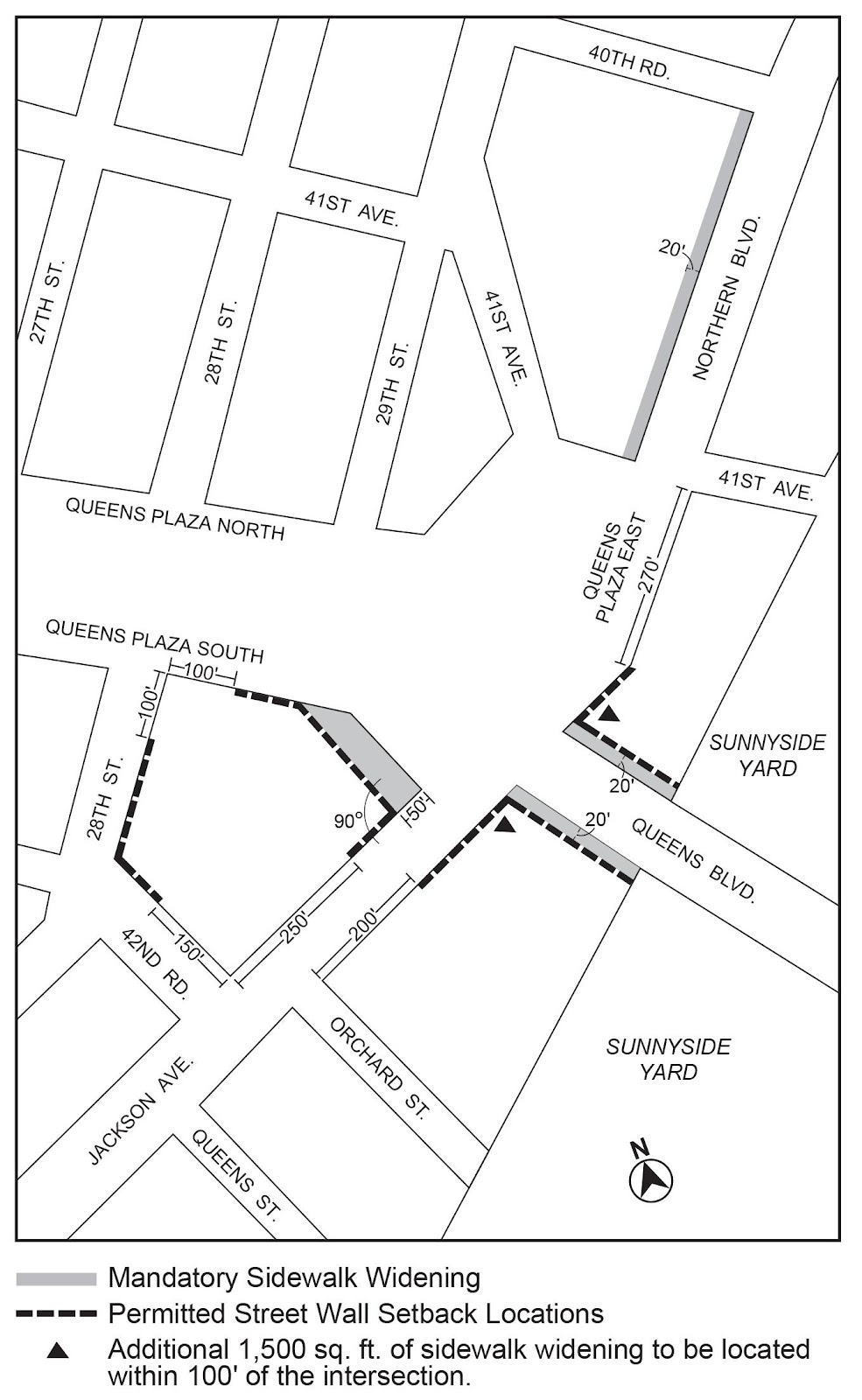
Streetscape regulations
The underlying ground floor level streetscape provisions set forth in Section 32-30 (STREETSCAPE REGULATIONS), inclusive, shall apply, except that:
- ground floor level street frontages along streets, or portions thereof, designated on Map 1 (Subdistrict Plan Map and Streetscape Regulations) in Appendix B of this Chapter, shall be considered Tier C street frontages;
- all other frontages in applicable Commercial Districts or in M1 Districts paired with a Residence District shall be considered Tier B street frontages; and
- in Manufacturing Districts, Type 1 and Type 2 street frontages designated below shall be subject to the alternate provisions for Tier B street frontages set forth in Section 32-322 (Alternate ground floor level regulations for certain frontages). In addition, where a zoning lot has frontage along a Type 1 street and a frontage along another street, no curb cuts accessing off-street parking spaces or loading spaces shall be permitted on such Type 1 street frontage.
For the purposes of this paragraph, Type 1 street frontages shall include: Vernon Boulevard; 11th Street; 21st Street; 23rd Street; and Queens Plaza South.
For the purposes of this paragraph, Type 2 street frontages shall include: 43rd Avenue; and 44th Avenue.
Sign regulations
In M1 Districts without a letter suffix paired with an R9 or R10 District, the sign regulations applicable to the Queens Plaza Subdistrict set forth in Section 117-513 may be applied.
The floor area regulations of the underlying districts shall apply, except as modified by the provisions of this Section, inclusive.
In M1 Districts paired with an R9 or R10 District, the following maximum floor area ratios shall apply:
MAXIMUM FLOOR AREA RATIO FOR ALL USES
| Residential Floor Area Ratio for Standard Residences | Residential Floor Area Ratio for Qualifying Affordable Housing or Qualifying Senior Housing | Community Facility Floor Area Ratio | Commercial or Manufacturing Floor Area Ratio | |
| M1-6/ R9 | 8.0 | 9.6 | 10.0 | 15.0 |
| M1-6/ R10 | 10.0 | 12.0 | 12.0 | 12.0 |
Such maximum floor area may be increased where a public plaza is provided pursuant to 117-223.
For zoning lots with a lot area of at least 20,000 square feet, up to 150,000 square feet of floor space within a public school constructed in whole or in part pursuant to a written agreement with the New York City School Construction Authority and subject to the jurisdiction of the Department of Education shall be exempt from the definition of floor area.
Authorization for a public plaza
In M1 Districts paired with an R9 or R10 District, for zoning lots with a lot area of at least 25,000 square feet, the City Planning Commission may authorize an increase in the maximum floor area ratio where a public plaza is provided on the zoning lot in accordance with the provisions of Section 37-70 (PUBLIC PLAZAS), inclusive.
In conjunction with such floor area bonus, the Commission may authorize modifications to the applicable bulk regulations of this Resolution, or to the regulations governing public plazas in Section 37-70, inclusive.
In order to grant such authorization, the Commission shall determine that the conditions and limitations of paragraph (a) and the findings of paragraph (b) are met.
- Conditions and limitations
The following conditions and limitations shall apply:- for the purposes of determining the bonus ratio to follow:
- for M1 Districts paired with an R9 District, the underlying bonus ratio for a C6-3 District shall apply; and
- for M1 Districts paired with an R10 District, the underlying bonus ratio for a C6- 4 District shall apply; and
the floor area bonus resulting from applying such ratio shall not exceed 20 percent of the maximum floor area ratio otherwise permitted by the applicable district regulations;
- modifications to the maximum permitted building height shall not result in an increase that exceeds 25 percent of the maximum building height otherwise permitted by the applicable district regulations; and
- modifications to the regulations governing public plazas shall be limited to:
- the basic design criteria set forth in Section 37-71, inclusive, other than the area dimensions provisions of Section 37-712;
- the access and circulation provisions set forth in Section 37-72, inclusive, other than hours of access set forth in Section 37-727; and
- the types and standards for amenities set forth in Section 37-74, inclusive.
- for the purposes of determining the bonus ratio to follow:
- Findings
The Commission shall find that:- the public benefit derived from the public plaza merits the amount of additional floor area being granted pursuant to this Section;
- the public plaza will be well-integrated with the overall pedestrian circulation network and will contribute to an enhanced streetscape;
- any modification to bulk regulations are the minimum extent necessary to reasonably accommodate the public plaza and the additional floor area granted pursuant to this Section and will not unduly obstruct access to light and air to surrounding streets and properties; and
- any modification to public plaza regulations are the minimum extent necessary, and will better align such public plaza regulations with unique site configurations or with the mixed-use character of the neighborhood.
The Commission may prescribe additional appropriate conditions and safeguards to minimize adverse effects on the character of the surrounding area.
Floor space used for accessory off-street parking spaces provided in any story located not more than 33 feet above curb level shall be exempt from the definition of floor area
Special Yard Regulations
The yard regulations of the underlying districts shall apply, except that in all M1 Districts paired with a Residence District, the yard regulations applicable to an M1 District with an A suffix shall apply to portions of buildings allocated to manufacturing, commercial, or community facility uses.
The height and setback regulations of the underlying districts shall apply, except as modified by the provisions this Section, inclusive.
Street wall location
In M1 Districts paired with a Residence District, the street wall location provisions of paragraph (a) of Section 123-651 shall apply, except that:
- along the portion of Vernon Boulevard south of 45th Avenue, the street line shall be considered a line, parallel to the Vernon Boulevard street line, located at a depth of five feet within the zoning lot; and
- along the following street frontages, for developments where the street wall width exceeds 150 feet, a minimum of 20 percent of the surface area of such street walls above the level of the second story, or a height of 30 feet, whichever is lower, shall either recess or project a minimum of three feet from the remaining surface of the street wall:
- 46th Avenue;
- 45th Road; and
- 44th Drive.
Height and setback
In M1 Districts paired with an R9 or R10 District, the following height and setback modifications shall apply:
- the maximum base height for both districts shall be 155 feet;
- for zoning lots located north of Queens Plaza North, the maximum height limit for residential buildings or residential portions of buildings:
- within 100 feet of 21st Street shall be 350 feet; and
- beyond 100 feet of 21st Street shall be 750 feet; and
- in other locations, no maximum height limit shall apply.
For zoning lots containing schools, the City Planning Commission may authorize the modification of any bulk regulation, other than floor area ratio, provided that the conditions in paragraph (a) and the findings in paragraph (b) are met.
- Conditions
Where maximum height limitations apply, modifications to maximum building height limits shall not exceed 30 feet. - Findings
The Commission shall find that:- such bulk modifications are the minimum extent necessary to reasonably accommodate the school and buildings or other structures on the zoning lot;
- the proposed modification does not impair the essential character of the surrounding area; and
- the proposed modification will not unduly obstruct access to light and air to surrounding streets or properties.
In M1 Districts without a letter suffix paired with an R9 or R10 District, the off-street parking provisions of Article I, Chapter 6, shall be modified as follows:
- the prohibition of curb cuts accessing entrances and exits to accessory off-street parking facilities and public parking garages on certain streets, as set forth in paragraphs (b) and (c) of Section 16-23 (Curb Cut Restrictions), shall also apply to 23rd Street; and
- the provisions of paragraph (c) of Section 16-12 (Permitted Parking for Non-residential Uses) shall be modified as follows: the maximum number of accessory off-street parking spaces permitted for a development or enlargement shall not exceed one space per 2,000 square feet of floor area or 250 spaces, whichever is less.
In the Special Long Island City Mixed Use District, the special regulations of Section 117-30, inclusive, shall apply in the Northern Hunters Point Waterfront Subdistrict.
General provisions
In the Northern Hunters Point Waterfront Subdistrict, the use, bulk, and parking regulations of the underlying districts shall apply, except as modified by the provisions of Section 117-30 (NORTHERN HUNTERS POINT WATERFRONT SUBDISTRICT), inclusive.
The regulations of Section 117-30, inclusive, are designed to implement the Northern Hunters Point Waterfront Subdistrict Plan as set forth in Appendix C to this Chapter.
In the Northern Hunters Point Waterfront Subdistrict, all zoning lots in M1 Districts paired with a Residence District without a letter suffix shall be considered waterfront zoning lots for the purposes of applying the height and setback regulations of Section 62-343 (Height and setback regulations in other medium- and high-density districts), as modified by the provisions of Section 117-34 (Special Height and Setback Regulations), inclusive. Such height and setback provisions, along with other applicable bulk regulations, may be modified by special permit of the City Planning Commission on such waterfront zoning lots pursuant to Section 62-837 (Bulk modifications on waterfront blocks).
In addition, all zoning lots under common ownership that are contiguous or would be contiguous but for a street established after November 12, 2025, shall be considered waterfront zoning lots for the purposes of applying the provisions of Section 62-50 (GENERAL REQUIREMENTS FOR VISUAL CORRIDORS AND WATERFRONT PUBLIC ACCESS AREAS), inclusive, as modified by Section 117-36 (Northern Hunters Point Waterfront Access Plan), inclusive.
In the Northern Hunters Point Waterfront Subdistrict, for zoning lots divided by district boundaries, the floor area resulting from the calculation of adjusted maximum floor area ratio pursuant to Section 77-22 (Floor Area Ratio) may be located anywhere on the zoning lot and the limitations on the amount of floor area ratio permitted on any portion of the zoning lot set forth in Section 77-22 shall not apply.
Special Use Regulations
The use regulations of the underlying districts shall apply, except as modified by the provisions of this Section, inclusive.
The underlying M1 District use regulations shall be modified such that uses listed under Use Group VI with a size limitation, as denoted with an “S” in the Use Group tables set forth in Section 42-16 (Use Group VI – Retail and Services), shall be permitted without a size limitation.
Streetscape regulations
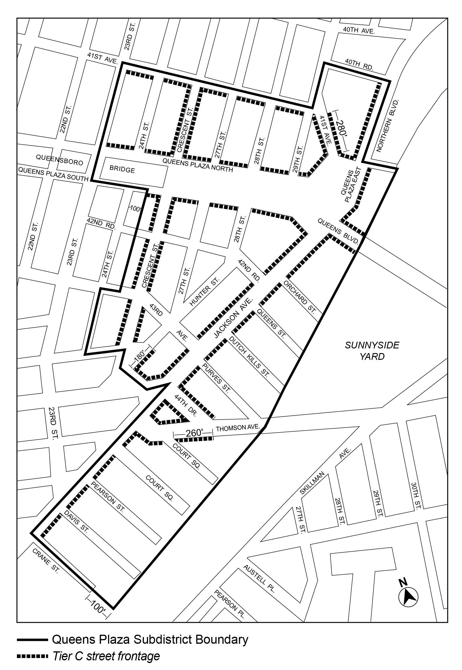
The underlying ground floor level streetscape provisions set forth in Section 32-30 (STREETSCAPE REGULATIONS), inclusive, shall apply, except that:
- ground floor level street frontage locations as designated on Map 2 (Streetscape Regulations) in Appendix C to this Chapter, shall be considered Tier C street frontages. In certain locations an asterisk designates the intersection of two street frontages where Tier C street frontage regulations need only apply to a 50 foot increment of ground floor level street wall along each street frontage of the designated intersection. Where a flexible zone is denoted, only one such 50 foot increment need be provided and may be located anywhere along any of the designated frontages; and
- all other frontages in applicable Commercial Districts or in M1 Districts paired with a Residence District shall be considered Tier B street frontages.
The floor area regulations of the underlying districts shall apply, except as modified by the provisions of this Section, inclusive.
For the purpose of applying the special floor area ratio provisions of this Subdistrict, six Subareas are designated. The locations of these subareas are shown on Map 1 (Subdistrict Plan Map and Designated Subareas) in Appendix C to this Chapter. Outside of a Subarea, the underlying floor area regulations shall apply.
Maximum floor area ratio
The maximum floor area ratio permitted for commercial, community facility, manufacturing, or residential uses in Subareas A through F is specified in the following table:
MAXIMUM FLOOR AREA RATIO FOR ALL USES
| Subarea | Residential Floor Area Ratio for Standard Residences | Residential Floor Area Ratio for Qualifying Affordable Housing or Qualifying Senior Housing | Community Facility Floor Area Ratio | Commercial or Manufacturing Floor Area Ratio |
| A | 8.42 | 10.10 | 10.0 | 8.0 |
| B | 6.00 | 7.20 | 7.2 | 6.5 |
| C1 | 6.45 | 7.74 | 7.2 | 4.0 |
| C2 | 6.50 | 7.80 | 7.2 | 4.0 |
| D | 7.02 | 8.42 | 8.0 | 8.0 |
| E | 6.00 | 7.20 | 4.0 | 6.5 |
| F | 5.00 | 6.00 | 4.0 | 4.0 |
In R9 Districts and in M1 Districts paired with an R9 District, for zoning lots with a minimum lot area of 40,000 square feet or more, for each square foot of publicly accessible, supplemental open area provided in accordance with Section 117-365 (Requirements for supplemental open spaces and amenities), inclusive, the maximum floor area permitted on the zoning lot may be increased by six square feet, provided that the resulting bonus floor area ratio shall not exceed 0.6.
For zoning lots with a lot area of at least 20,000 square feet, up to 150,000 square feet of floor space within a public school constructed in whole or in part pursuant to a written agreement with the New York City School Construction Authority and subject to the jurisdiction of the Department of Education shall be exempt from the definition of floor area.
Floor space used for accessory off-street parking spaces provided in any story located not more than 33 feet above curb level shall be exempt from the definition of floor area.
The Chairperson of the City Planning Commission shall allow, by certification, a transfer of floor area between two or more zoning lots under single fee ownership or alternate ownership arrangement that are contiguous, or would be contiguous but for their separation by a street. Such certification for a transfer of floor area shall be subject to the conditions of paragraph (a) and application requirements of paragraph (b) of this Section.
For the purposes of this Section, the “granting site” shall mean the zoning lot that transfers floor area pursuant to this Section, and a “receiving site” shall mean a zoning lot that receives additional floor area pursuant to this Section.
- Conditions
The maximum amount of floor area that may be transferred from the granting site shall be the maximum floor area ratio permitted pursuant to the applicable provisions of Section 117-32, inclusive, less the total floor area of all existing buildings. Each transfer, once completed, shall irrevocably reduce the amount of floor area that may be transferred. - Application requirements
An application filed with the Chairperson for certification pursuant to this Section shall be made jointly by the owners of the granting site and the receiving site. Such application shall include site plans and zoning calculations for the granting site and receiving site showing the additional floor area associated with the transfer.
Additionally, at the time of certification, the owners of the granting site and of the receiving site shall submit to the Chairperson a copy of the transfer instrument legally sufficient in both form and content to effect such a transfer. Notice of the restrictions upon further development or enlargement of the granting site and the receiving site shall be filed by the owners of the respective lots in the Office of the Register of the City of New York (County of New York). Proof of recordation shall be submitted to the Chairperson. Both the transfer instrument and the notices of restrictions shall specify the total amount of floor area transferred and shall specify, by block and lot numbers, the granting site and the receiving site that are a party to such transfer.
The Chairperson shall certify to the Department of Buildings that development or enlargement is in compliance with the provisions of this Section only after the transfer instrument and notice of restrictions required by this paragraph have been executed and recorded with proof of recordation provided to the Chairperson. Such certification shall be a precondition to the filing for or issuing of any building permit allowing more than the basic maximum floor area ratio for such development.
A separate application shall be filed for each transfer of floor area to any receiving site pursuant to this Section.
Special Yard Regulations
The underlying yard regulations of Section 62-33 (Special Yard and Lot Regulations on Waterfront Blocks), inclusive, shall apply. In addition, where a waterfront yard is not required pursuant to Section 62-33, yards meeting the dimensional requirements of Section 62-332 (Rear yards and waterfront yards) shall be provided in connection with any development, in accordance with the provisions of paragraph (f) of Section 62-912 (Elements of a Waterfront Access Plan).
In Manufacturing Districts, the underlying height and setback regulations shall apply.
In M1 Districts paired with a Residence District with a letter suffix, the provisions of Section 123-65 (Special Height and Setback Regulations in Special Mixed Use Districts With R6 Through R12 District Designations), inclusive, shall apply, except as modified by the provisions of this Section, inclusive.
In other districts, the underlying height and setback regulations shall apply, except as modified by the provisions of this Section, inclusive.
Street wall location
In Residence Districts, and M1 Districts paired with Residence Districts, the street wall location provisions of paragraph (a) of Section 123-651 (Street wall location for all buildings) shall apply, except that:
- along the portion of Vernon Boulevard south of 44th Drive, the street line shall be considered a line, parallel to the Vernon Boulevard street line, located at a depth of five feet within the zoning lot;
- along the southerly street line of 45th Avenue, beyond 100 feet of Vernon Boulevard, a sidewalk widening, with a depth of five feet, as measured perpendicular to the street line, shall be provided in accordance with Department of Transportation standards, and shall be accessible to the public. The southerly edge of such sidewalk widening shall be considered the street line for the purposes of applying the street wall location provisions;
- no minimum percentage of street wall need be located within a set distance of the street line:
- along shore public walkways;
- along the portion of Vernon Boulevard north of 44th Avenue and south of 43rd Road; and
- along the portion of 5th Street that is within 150 feet of its intersection with 44th Drive, as measured from both the northerly and southerly street lines of 44th Drive;
- along the northerly portion of 44th Drive that is within 250 feet of its intersection with 5th Street;
- along the southerly portion of 44th Drive that is east of 5th Street and west of Vernon Boulevard; and
- along the northerly portion of 45th Avenue that is within 250 feet of its intersection with Vernon Boulevard; and
- such street walls shall extend to a minimum base of at least 40 feet, or the height of the building, whichever is less.
In Residence Districts and in M1 Districts paired with Residence Districts, the maximum base heights, required minimum setback and required street wall articulation shall be as follows:
- The maximum base height before a required setback shall be:
- 85 feet in the following locations:
- along the shore public walkways located along Anable Basin; and
- along the portion of 44th Avenue that is beyond 100 feet of both Vernon Boulevard and 5th Street;
- 125 feet in the following locations:
- within 100 feet of the street line along the portion of Vernon Boulevard that is located north of 45th Avenue;
- within 100 feet of the street line along the portion of 44th Drive that is beyond 100 feet from the easterly street line of 5th Street; and
- along the remaining northerly portion of 44th Avenue; and
- 105 feet along all other streets, or portions thereof.
- 85 feet in the following locations:
- At a height not lower than the minimum base height or higher than the maximum base height, setbacks shall be provided in accordance with the provisions of Section 23-433 (Standard setback regulations), except that:
- along a shore public walkway, a setback of 30 feet shall be required, as measured from the upland boundary of the shore public walkway;
- no setback need be provided along the visual corridor located at the prolongation of 45th Avenue;
- for the purposes of applying such setback regulations, the following may be considered wide streets:
- portions of streets adjoining public parks;
- upland connections or visual corridors at the prolongation of streets on blocks surrounding Anable Basin;
- other upland connections or visual corridors along the northerly side of Anable Basin; and
- along the portion of 5th Street south of Anable Basin that adjoins a waterfront block.
Dormers provided in accordance with paragraph (b) of Section 23-413 (Permitted obstructions in certain districts) shall be permitted within any setback area, provided that the depth of encroachment of a dormer facing the shore public walkway shall not exceed 15 feet.
- Street wall articulation shall be provided as follows:
- For developments where the street wall width facing shore public walkways along Anable Basin exceeds 150 feet, a minimum of 20 percent of the surface area of such street walls, as measured above the level of adjoining grade, shall either recess or project a minimum of three feet from the remaining surface of the street wall.
- Along the following frontages, for developments where the street wall width exceeds 150 feet, a minimum of 20 percent of the surface area of such street walls above the level of the second story, or a height of 30 feet, whichever is lower, shall either recess or project a minimum of three feet from the remaining surface of the street wall:
- 46th Avenue;
- the southerly side of 45th Avenue;
- 44th Drive and the upland connection or visual corridor at the prolongation of 44th Drive; and
- the portion of 44th Avenue located east of 5th Street.
- After the required setback, the following shall apply:
- in M1 Districts paired with a Residence District with a letter suffix, after the required setback, the maximum height limits set forth in paragraph (a) of Section 123-652 (Special base and building heights) shall apply; and
- in Residence Districts without a letter suffix, and in M1 Districts paired with Residence Districts without a letter suffix, after the required setback, a building may rise to the maximum transition height, in accordance with Section 117-343 (Transition heights), and may provide towers in accordance with Section 117-344 (Towers).
Transition heights
In Residence Districts without a letter suffix, and in M1 Districts paired with Residence Districts without a letter suffix, after the required setback provided in accordance with paragraph (b) of Section 117-342 (Base heights, minimum setbacks and articulation), a building may rise to a maximum transition height of 350 feet, provided that:
(a) within 100 feet of the easterly street line of 5th Street, north of Anable Basin, the footprint of a building, or portion thereof, within the transition heights shall be limited to that of a tower provided above such transition height in accordance with Section 117-344 (Towers);
(b) along any single street frontage, the aggregate width of street walls above the required setback and below the maximum transition height shall not exceed 300 feet, and the maximum street wall width of any individual, contiguous street wall, shall not exceed 200 feet; and
(c) south of Anable Basin, portions of buildings utilizing transition heights shall only be permitted in the following locations:
(1) within 150 feet of 5th Street; and
(2) east of an upland connection or visual corridor, where applicable.
Towers
In Residence Districts without a letter suffix, and in M1 Districts paired with Residence Districts without a letter suffix, any portion of a building that exceeds the maximum transition height shall be subject to the following tower regulations:
- For residential stories, each tower footprint shall not exceed a gross area of 10,000 square feet, exclusive of the square footage contained in any permitted dormers.
- The provisions for maximum width of towers facing a shoreline set forth in paragraph (d)(1) of Section 62-343 (Height and setback regulations in other medium- and high-density districts) shall apply, except that:
- beyond 200 feet east of 5th Street, north of Anable Basin, such maximum widths need not apply;
- for towers that face a single shoreline, the following modifications shall apply:
- where such shoreline is the northerly portion of Anable Basin, the maximum width of such tower face may be increased to 115 feet;
- where no setbacks are required pursuant to Section 117-342 (Base heights, minimum setbacks and articulation), the maximum width of such tower may be increased to 130 feet; and
- where such shoreline extends between the prolongation of 44th Road and 44th Drive, the maximum width of such tower may be increased to 130 feet.
For the purposes of this Section, wherever a tower faces a shoreline but there is a separate building located between such tower face and the shoreline, such tower face shall not be considered to be facing the shoreline along that frontage.
- The minimum distance between any two towers on the same or an adjoining zoning lot shall be as follows:
- for towers facing the northerly or southerly shoreline of Anable Basin east of 5th Street, or the prolongation thereof, there shall be a minimum of 100 feet between any two towers; and
- in other locations, the regulations governing underlying distance between buildings shall apply, except that the maximum length of overlap between any two tower faces that are located within 100 feet of another tower face on the same or an adjacent zoning lot, as measured perpendicular to each tower face, shall not exceed:
- 100 feet, at or below a height of 500 feet; or
- 75 feet, for portions of towers that exceed a height of 500 feet.
- Tower heights shall be subject to the following limitations:
- in M1 Districts paired with R8 Districts, tower heights and locations shall be limited in the following locations:
- where located north of Anable Basin, the maximum tower height south of 44th Drive shall not exceed 500 feet; and
- where located south of Anable Basin, towers shall only be permitted within 100 feet of 5th Street, and the maximum tower height shall not exceed 500 feet;
- in all other locations, no maximum height limits shall apply to towers. However, for towers that exceed a height of 500 feet, the gross area of any story within the highest 15 percent of the building shall not exceed 90 percent of the gross area of that story located directly below the highest 15 percent of the building;
- there shall be at least 50 feet in height difference between any two immediately adjacent towers on the same or an adjacent zoning lot. For zoning lots separated by Anable Basin, this provision shall apply only to immediately adjacent towers on the same upland portion of the Basin; and
- the penthouse allowances set forth in paragraph (c)(1) of Section 62-34 (Height and Setback Regulations on Waterfront Blocks) shall not apply.
- in M1 Districts paired with R8 Districts, tower heights and locations shall be limited in the following locations:
For zoning lots containing schools, the City Planning Commission may authorize the modification of any bulk regulation, other than floor area ratio, provided that the conditions in paragraph (a) and the findings in paragraph (b) are met.
- Conditions
Where maximum height limitations apply, modifications to maximum building height limits shall not exceed 30 feet. - Findings
The Commission shall find that:- such bulk modifications are the minimum extent necessary to reasonably accommodate the school and buildings or other structures on the zoning lot;
- the proposed modification does not impair the essential character of the surrounding area; and
- the proposed modification will not unduly obstruct access to light and air to surrounding streets or properties.
The boundaries of the area comprising the Northern Hunters Point Waterfront Access Plan and the location of certain features mandated or permitted by the Plan are shown in Maps 3 through 5 through located in Appendix C to this Chapter. The plan area has been divided into parcels consisting of tax blocks and lots and other lands existing on November 12, 2025, as follows:
Parcel 1: Block 477, Lots 13, 15, 20
Parcel 2: Block 477, Lot 24
Parcel 3: Block 488, Lot 114
Parcel 4: Block 488, Lot 1, 2, 3
Parcel 5: Block 488, Lots 11, 15, 35
Block 489, Lots 1, 23, 46
Parcel 6: Beginning at the intersection of 44th Drive and 5th Street extending westerly to the U.S. Pierhead and Bulkhead line abutting Parcel 5 on the northern edge and Parcel 7 on the southern edge
Parcel 7: Block 25, Lot 15
Parcel 8: Block 25, Lots 1, 9, 10, 11
Block 26, Lot 10
Parcel 9: Block 26, Lots 1, 2, 3, 4
Parcel 10: Block 26, Lots 17 and 21
Definitions
Definitions specifically applicable to the Northern Hunters Point Waterfront Access Plan are set forth in this Section. Other defined terms are set forth in Section 117-01 and Section 12-10. In addition, for the purposes of Section 117-36, inclusive, the definition of development shall be as set forth in Section 62-11 (Definitions).
Active recreation space
For the purposes of this Chapter, “active recreation space” shall mean a designated area outdoors designed and equipped for recreational activities that involve physical movement, exercise, sports or play. These spaces accommodate a wide range of dynamic uses and may include, but are not limited to:
- sports courts, such as tennis, basketball, volleyball, pickleball or ping pong courts;
- athletic fields, such as baseball, football, soccer, cricket, rugby or lacrosse fields;
- water-based recreation, such as splash parks, sprinkler parks or swimming pools;
- water access and interaction space, such as boat and kayak launches or urban beaches;
- adventure and skill-based activities, such as skate parks, climbing walls or obstacle courses;
- social and leisure games, such as bocce, shuffleboard, mini golf or horseshoe pits;
- fitness facilities, such as outdoor gyms or yoga areas, exercise circuits or jogging tracks;
- play spaces, such as playgrounds, tot lots or adventure playgrounds; or
- community and cultural spaces, such as open-air amphitheaters, performance stages or gathering lawns.
Area-wide modifications
The provisions of Article VI, Chapter 2 (Special Regulations Applying in the Waterfront Area) shall be modified in the area comprising the Northern Hunters Point Waterfront Access Plan by the provisions of this Section.
- All waterfront public access areas
- Gates
The provisions of paragraph (d) of Section 62-651 (Guardrails, gates and other protective barriers) shall not apply. - Fences and walls
The provisions of paragraph (c) of Section 62-651 shall apply, except that fences around the perimeter of areas designated as active recreation space may exceed 36 inches in height. - Kiosks and boathouses
Section 62-611 (Permitted obstructions) shall be modified to permit the following in all areas:- kiosks and boathouses which comply with the special design guidelines of Section 117-364 (Special design standards); and
- storage areas and structures, which are accessory to water-dependent uses and have an area of 150 square feet or less.
- Permitted obstructions
The location requirements of paragraph (c) of Section 62-611 shall not apply to tot-lots and playgrounds.
- Gates
- Shore public walkways
The circulation and access provisions of paragraph (a) of Section 62-62 (Design Requirements for Shore Public Walkways and Supplemental Public Access Areas) shall be modified as follows:- Location of circulation paths
The required primary circulation path within a shore public walkway shall be provided within 10 feet of the shoreline for at least 15 percent of the length of such shoreline, and the remainder of the path may be located anywhere within the shore public walkway or supplemental public access area. Where secondary circulation paths are provided, such paths may count as a part of the required circulation path for satisfying the locational requirement of being within 10 feet of the shoreline for at least 20 percent of the length of such shoreline and may utilize the permitted paving materials pursuant to paragraphs (a)(1) and (a)(2) of Section 62-656. - Level of circulation paths
At least 70 percent of a required primary circulation path shall be located at a level not less than six feet above the shoreline. - Width of secondary circulation paths
Secondary paths, where provided, shall have a minimum clear width of at least 4 feet, 6 inches. - Connection between circulation paths
Stairs and ramps shall be permitted to connect primary and secondary paths.
- Location of circulation paths
- Supplemental public access areas
- Configuration requirements
The area of a supplemental public access area may utilize width to depth ratios other than the minimum width to depth ratio requirements of paragraph (a)(1) of Section 62-571 (Location and area requirements for supplemental public access areas) for not more than 20 percent of such area. - Lawns
The provisions of paragraph (c)(1) of Section 62-62 (Design Requirements for Shore Public Walkways and Supplemental Public Access Areas) shall be modified so that a lawn shall only be required where a supplemental public access area is greater than 15,000 square feet. In addition, a lawn may be substituted for an active recreation space of equivalent size.
- Configuration requirements
- Screening
Wherever a screening buffer is required to be provided, the minimum width of such buffer shall be four feet.
In addition to the waiver allowances of paragraph (c)(2)(iii) of Section 62-62, no screening buffer shall be required along the upland boundary, or portion thereof, which is adjacent to an unenclosed seating area accessory to a use listed in Use Group VI. Where a screening buffer is waived, design features shall be utilized to demarcate the shore public walkway or supplemental public access area from the non-publicly accessible area, which may include, but shall not be limited to, railings, fences, planting boxes, and distinct paving materials.
The provisions of Sections 62-52 (Applicability of Waterfront Public Access Area Requirements) and 62-60 (DESIGN REQUIREMENTS FOR WATERFRONT PUBLIC ACCESS AREAS), inclusive, are modified at the designated locations along with visual corridors as shown on Map 4 (Public Access Elements Designation) and Map 5 (Visual Corridors Designation) of Appendix C to the Chapter:
- Parcel 1
An upland connection and visual corridor shall be located between Vernon Boulevard and the shore public walkway within the designated flexible location zone on Parcel 1. The upland connection shall intersect Vernon Boulevard at its intersection with Queens Plaza South. - Parcel 2
No upland connection shall be required within Parcel 2. However, a direct connection shall be provided between the shore public walkway and the public access area at the prolongation of 43rd Avenue.
In addition, where a development not otherwise exempt from waterfront public access area requirements is comprised exclusively of new publicly accessible open areas provided along the shoreline, only the provisions applicable to a shore public walkway set forth in Sections 62-50 and 62-60, inclusive, as modified by Section 117-362, shall apply in conjunction with such development. - Parcel 3
- Upland connections and visual corridors
Upland connections and visual corridors shall be provided through Parcel 3 between Vernon Boulevard and the shore public walkway:- at the prolongation of 43rd Road; and
- in the flexible zone that begins 200 feet south of the prolongation of 43rd Road and ends at the southern boundary of Parcel 3.
- Supplemental public access area
The supplemental public access area shall abut the shore public walkway continuously along its longest side, and shall also abut the southern boundary of required upland connection as described in paragraph (c)(1) of this Section where it meets the shore public walkway. The upland connection may cut across the supplemental public access area, provided that any resulting supplemental public access area shall measure at least 5,000 square feet.
As an alternative, a required supplemental public access area of at least 5,000 square feet may abut the entire length of the prolongation of 43rd Avenue provided that it also abuts both the shore public walkway and Vernon Boulevard.
In addition, where a development not otherwise exempt from waterfront public access area requirements is comprised exclusively of new publicly accessible open areas provided along the shoreline, only the provisions applicable to a shore public walkways set forth in Sections 62-50 and 62-60, inclusive, as modified by Section 117-362, shall apply in conjunction with such development.
- Upland connections and visual corridors
- Parcel 4
A Type 1 upland connection pursuant to paragraph (a)(1) of Section 62-561 (Types of upland connections) and a visual corridor coincident with such upland connection shall be provided through Parcel 4 at the prolongation of 44th Avenue to the shore public walkway.
However, the provisions of Sections 62-50 and Section 62-60, inclusive, as modified by Section 117-36, inclusive, relating to required waterfront public access areas and visual corridors, shall be inapplicable if public access and visual corridors are provided pursuant to restrictive declaration, number D-138, executed by the RAK Tennis Corporation on July 29, 1991, and as such may be modified pursuant to the terms of the declaration and in accordance with Section 62-12 (Applicability to Developments in the Waterfront Area). - Parcel 5
- Supplemental public access area
The requirements of Section 62-57 (Requirements for Supplemental Public Access Areas) shall not apply to supplemental public access areas on Parcel 5. - Shore public walkway
The shore public walkway on Parcel 5 shall have a seaward edge that is contiguous with the seaward edge of the waterfront yard established pursuant to Section 62-332 (Rear yards and waterfront yards), and shall extend to the western boundary of 5th Street.
- Supplemental public access area
- Parcel 6
A Type 1 upland connection pursuant to paragraph (a)(1) of Section 62-561 and a visual corridor coincident with such upland connection shall be provided through Parcel 6 at prolongation of 44th Drive between 5th Street and the shore public walkway. However, the reduction provisions of paragraph (a)(1) of Section 62-561 shall not apply to upland connections in Parcel 6. - Parcel 7
- Upland connection
A Type 1 upland connection pursuant to paragraph (a)(1) of Section 62-561 shall be provided through Parcel 7 and shall be located on the southerly prolongation of 5th Street. - Visual corridors
Visual corridors shall be provided in the following locations:- coincident with the upland connection required pursuant to paragraph (g)(1) of this Section;
- within the flexible zone at the westerly prolongation of 45th Avenue to the shore public walkway; and
- along the boundary between Parcel 7 and Parcel 8 with a width of not less than 25 feet on each Parcel.
- Supplemental public access area
The supplemental public access area shall abut the shore public walkway continuously along its longest side and shall be located in the area designated on Map 4 (Public Access Elements Designation) and Map 5 (Visual Corridors Designation) of Appendix C to this Chapter.
- Upland connection
- Parcel 8
- Upland connection and visual corridor
A Type 1 upland connection pursuant to paragraph (a)(1) of Section 62-561 shall be provided through Parcel 8 on the westerly prolongation of 45th Road, at the abutting boundary of Parcel 8 and Parcel 9. Such upland connection shall have a width of not less than 30 feet on each Parcel. Where portions of the abutting upland connection located outside of either Parcel will not be constructed concurrently, the applicant shall follow the provisions of paragraph (b) of Section 117-366 (Special review provisions).
A visual corridor coincident with such upland connection shall be provided. - Supplemental public access area
The supplemental public access area shall abut the shore public walkway, the upland connection as described in paragraph (h)(1) of this Section, and Vernon Boulevard. However, the longest side of the supplemental public access area need not abut the upland connection.
- Upland connection and visual corridor
- Parcel 9
- Shore public walkway
The underlying requirements for shore public walkway apply, except that the reduction provisions of paragraph (a)(3)(i) of Section 62-53 (Requirements for Shore Public Walkways) shall not apply. - Upland connection and visual corridor
An upland connection and visual corridor shall be provided in accordance with paragraph (h)(1) of this Section.
- Shore public walkway
- Parcel 10
A Type 1 upland connection pursuant to paragraph (a)(1) of Section 62-561 and a visual corridor coincident with such upland connection shall be provided through Parcel 10 within the flexible location zone located 150 feet east of 5th Street from 46th Avenue to the shore public walkway.
Special design standards
The design requirements of Section 62-60 (DESIGN REQUIREMENTS FOR WATERFRONT PUBLIC ACCESS AREAS), inclusive, are modified by the provisions of this Section.
- Special design standards for seating
- Seating depth
The minimum seating depth requirements of paragraph (b) of Section 62-652 shall be modified to 16 inches. - Armrests
At least 50 percent of all required seating shall include armrests. - Design feature seating
Along Anable Basin, planter ledges, seating walls, and seating steps may qualify towards required seating provided that they constitute no more than 40 percent of the required seating. Walls and planter ledges shall be flat and smooth with at least one inch radius rounded edges.
- Seating depth
- Special design standards for lighting
Along Anable Basin, the lighting requirements of Section 62-653 (Lighting) shall be modified such that an average maintained level of illumination not less than 0.5 horizontal foot candle (lumens per foot) shall be provided throughout all walkable areas, and the average illumination to minimum foot candle uniformity ratio shall be no greater than 6:1 within any waterfront public access area. - Special design standards for planting
Reduction in planting requirement- Shore public walkway and supplemental public access areas
An area equal to at least 35 percent of the area of the shore public walkway and supplemental public access area shall be planted. Such planting area may be reduced to 30 percent if an amenity is provided in accordance with the following tables:
TABLE 1Amenity Reduction per feature (in square feet)
Historic interpretation elements
20 Public art pieces
100
TABLE 2Amenity Ratio of reduction to size of feature
Active recreation space
1.1 Dog runs
1.1 Comfort stations
1.1 Kiosks 1.1
Such planting requirements may be further reduced to 20 percent along Anable Basin. - Upland connection
For Type 1 upland connections, at least 30 percent of the area of the upland connection may be planted in accordance with the provisions set forth in Section 62-655 (Planting and trees).
- Shore public walkway and supplemental public access areas
- Special design standards for paving
The maximum area for unit pavers and concrete slabs specified in paragraphs (b)(1) and (b)(3) of Section 62-656 shall not apply. - Special design standards for kiosks and boathouses
The standards of this Section shall be applicable for sites providing greater than 20,000 square feet of waterfront public access areas.- Maximum size
Kiosks permitted under this Section shall have an area no greater than 400 square feet. Boathouses permitted under this Section shall have an area no greater than 800 square feet. - Location
A kiosk or boathouse may be located within a shore public walkway, provided that any portion of a kiosk or boathouse located within the area comprising an upper level of such shore public walkway shall be located below the walking surface of such upper level. Kiosks and boathouses shall not reduce compliance with other requirements, including planting or circulation, except as modified by the provisions of paragraph (c) of this Section. - Minimum design requirements
A minimum of 25 percent of any wall facing a circulation path, as measured from the level of the adjoining circulation path to the roof of the kiosk or boathouse, shall be provided as transparent material.
Blank walls on kiosks and boathouses that exceed five feet in height and 10 feet in width shall be treated with one or more of the following visual mitigation elements:- additional transparency consisting of an additional 25 percent of the wall facing a circulation path, as measured from the level of the adjoining circulation path to the roof of the kiosk or boathouse;
- plantings in planting beds or planter boxes at least two feet in height, at least six feet in width and at least two feet in depth when measured perpendicular to the wall of the kiosk or boathouse;
- fixed benches with or without backs of at least six linear feet; or
- wall treatments in the form of permitted signs, graphic or sculptural art or decorative screening. Such wall treatments must be at least six feet in height and have a minimum width of six feet.
- Maximum size
- Special design modifications for upland connections
The Chairperson of the City Planning Commission may modify the design requirements for upland connections where the Chairperson certifies to the Commissioner of the Department of Buildings that such a change is the minimum necessary to accommodate subsurface sewer infrastructure. Any application for such change shall include a site plan from a licensed architect or engineer that conveys the extent of the needs and required modifications, as well as a letter from the Department of Environmental Protection describing the needs for such modifications.
For all zoning lots utilizing bonus floor area set forth in Section 117-322 (Floor area bonus for active recreation space), the supplemental open area provisions of paragraph (a) of this Section and the supplemental amenities of paragraph (b) of this Section shall be met.
- Supplemental open area
Any publicly accessible supplemental open area shall be consistent in size with the open area created pursuant to the provisions of Section 117-322, but in no event shall such open area have a size of less than 4,000 square feet. Such open area shall be in addition to any area allocated to a waterfront public access area, as applicable, and shall connect directly to either waterfront public access areas or adjoining streets. Supplemental open areas shall be subject to the design requirements for supplemental public access areas set forth in Section 62-60 (DESIGN REQUIREMENTS FOR WATERFRONT PUBLIC ACCESS AREAS), inclusive, as such provisions are modified by the provisions of Section 117-364 (Special design standards), inclusive. All amenities provided in supplemental open areas shall either match or shall be comparable with amenities in a waterfront public access area on the same zoning lot with regard to quality, materials, finishes and form. In addition, supplemental open areas shall be subject to the maintenance and operation requirements of Section 62-70, inclusive, and the review procedures of Section 62-80, inclusive. - Supplemental amenities
Supplemental amenities, in the form of active recreation space or public restrooms, shall be provided in accordance with the following regulations with regards to the minimum points required for the size of supplemental open area. Such amenities may be provided either in the supplemental open area or in waterfront public access areas on the same zoning lot. No amenity included pursuant to this Section may count towards meeting a requirement of a waterfront public access area.- Minimum points required
The minimum required amount of points on a zoning lot shall be equivalent to one point per every additional 2,000 square feet of supplemental open space, except that the maximum points of amenity for any zoning lot need not exceed ten. Fractions equal to or greater than one-half resulting from this calculation shall be considered to be one point. - Calculating points for amenities
For every 1,000 square feet of active recreation space provided, one point shall be generated. However, where such active recreation space involves open and flexible areas with no permanent infrastructure or equipment, one point shall be generated for every 2,000 square feet of amenity.
The area allocated to the active recreation space shall include those areas bounded by the physical equipment associated with such space, as applicable, as well as the additional space around the equipment for access, circulation and buffering. Where an amenity involves water access, the area may include areas associated with the amenity both upland of and seaward of the shoreline, as applicable and, where watercraft launches are provided, may include temporary storage facilities.
No more than two points shall be permitted for multiple courts, leisure games or other facilities allocated to the same type of active recreation. For example, no more than two points may be generated by ping pong courts; however, further points may be generated from other types of courts such as volleyball courts.
For every 200 square feet of public restroom, one point shall be generated and the maximum points permitted for public restrooms shall not exceed four. - Additional requirements for large zoning lots
Where the size of a supplemental open area exceeds 5,000 square feet, a singular active recreation space equivalent to at least two points shall be provided. Where a supplemental open area exceeds 10,000 square feet, either a singular amenity equivalent to at least three points shall be provided, or two amenities each equivalent to at least two points shall be provided.
- Minimum points required
Special review provisions
The Chairperson of the City Planning Commission shall, by certification pursuant to Section 62-811 (Waterfront public access and visual corridors), further certify the following provisions as applicable:
- Waterfront public access area phasing
Where more than one building is developed in phases, the mandatory public access area may be constructed in phases, provided that the Chairperson certifies the following criteria are met:- a plan has been submitted that provides for an amount of public access area proportionate to the amount of floor area being developed in each phase;
- the square footage of public access area provided in any phase is in proportion to the total public access area requirement based on the area being developed. Any public access area provided in an earlier phase in excess of the amount required for such phase may be applied to a later phase;
- the public access area being proposed in any phase shall not prevent the total amount of public access area required for such area from being achieved;
- any phased portion of the required public access area shall comply with the minimum widths and other dimensions required for the public access areas;
- any phased portion of the required public access area shall connect directly to either a street or an improved public access area; and
- a proportionate amount of planting and seating shall be included within each phase.
- Upland connection phasing
Where an upland connection is designated on two or more parcels, and the portion of such upland connection located outside of the applicant’s parcel has previously been certified as part of a waterfront public access area, the Chairperson shall certify that the proposed upland connection on the applicant’s parcel is consistent with that of the prior certification, including with respect to the proposed amenities and design elements therein.
In R9 Districts and in M1 Districts paired with an R9 District, for zoning lots with a minimum lot area of 40,000 square feet or more, for each square foot of publicly accessible, supplemental open area provided in accordance with Section 117-365 (Requirements for supplemental open spaces and amenities), inclusive, the maximum floor area permitted on the zoning lot may be increased by six square feet, provided that the resulting bonus floor area ratio shall not exceed 0.6.
COURT SQUARE SUBDISTRICT
In the Special Long Island City Mixed Use District, the special regulations of Section 117-40, inclusive, shall apply in the Court Square Subdistrict.
General provisions
In the Court Square Subdistrict, the use, #bulk, and parking regulations of the underlying districts shall apply, except as modified by the provisions of Section 117-40 (COURT SQUARE SUBDISTRICT), inclusive.
Mandatory subway improvements are elements of the Subdistrict Plan, which shall be built by the developer of the zoning lot to which they apply.
The Subdistrict Plan for the Court Square Subdistrict specifies the location of Blocks 1, 2 and 3 and identifies the improvements to be provided in the District under the provisions of this Chapter. The elements of the Subdistrict Plan are set forth in Appendix D of this Chapter, which consists of the Subdistrict Plan Map and Description of Improvements, and is incorporated into the provisions of this Chapter.
Zoning lots of at least 10,000 square feet with buildings containing at least 70,000 square feet of floor area are subject to the provisions of the underlying C5-3 District, as modified by Sections 117-40 through 117-45, inclusive.
All other zoning lots are subject to the use provisions of the underlying C5-3 District and the bulk provisions of an M1-4/R6B District.
Special bulk regulations
(a) Developments or enlargements on zoning lots that meet the standards of Section 117-44 and provide mandatory subway improvements as required by Section 117-44, may be developed or enlarged to a floor area ratio of 15.0. Developments or enlargements on zoning lots that do not meet the minimum standards of Section 117-44 shall not exceed the maximum floor area ratio of the M1-4/R6B designated district for the applicable use.
(b) The following provisions shall not apply within the Court Square Subdistrict:
Section 33-13 (Floor Area Bonus for a Public Plaza)
Section 33-14 (Floor Area Bonus for Arcades)
Section 33-26 (Minimum Required Rear Yards)
Section 34-223 (Floor area bonus for a public plaza)
Section 34-224 (Floor area bonus for an arcade)
Section 34-23 (Modification of Yard and Open Area Regulations).
(c) The height and setback regulations of the underlying C5-3 District shall apply, except that:
(1) no building or other structure shall exceed a height of 85 feet above the base plane within the area bounded by 23rd Street, 44th Road, a line 60 feet east of and parallel to 23rd Street, and 45th Avenue; and
(2) on Blocks 1 and 3, the street wall of a building or other structure shall be located on the street line or sidewalk widening line, where applicable, and extend along the entire street frontage of the zoning lot up to at least a height of 60 feet and a maximum height of 85 feet before setback, except any portion of a building on Block 3 fronting upon 23rd Street may rise to a maximum height of 125 feet before setback. Recesses, not to exceed three feet in depth from the street line, shall be permitted on the ground floor where required to provide access to the building. Above the level of the second story, up to 30 percent of the aggregate width of street walls may be located beyond the street line, provided no such recesses are within 15 feet of an adjacent building.
Above the highest applicable maximum street wall height, the underlying height and setback regulations shall apply. However, the underlying tower regulations shall be modified:
(i) to permit portions of buildings that exceed a height of 85 feet to be set back at least five feet from a wide street line, provided no portion of such building that exceeds a height of 85 feet is located within 15 feet of a side lot line; and
(ii) so that the provisions of Section 33-451 (In certain specified Commercial Districts) regulating the aggregate area of a tower within 50 feet of a narrow street shall not apply to any building or portion of such building on Block 3 fronting upon 45th Avenue.
The provisions of this paragraph (c)(2) shall not apply to enlargements on zoning lots existing on June 30, 2009, where such zoning lot includes an existing building to remain with at least 300,000 square feet of floor area.
Sign regulations
All requirements of Section 32-60 (SIGN REGULATIONS) shall apply, except for Sections 32-642 (Nonilluminated signs), 32-644 (Illuminated or flashing signs in C4, C5-4, C6 or C7 Districts) and 32-655 (Height of signs in all other Commercial Districts).
Non-illuminated, illuminated or flashing signs are permitted with a total surface area (in square feet) not exceeding five times the street frontage of the zoning lot, in feet, but in no event shall the total surface area exceed 500 square feet for interior or through lots or 500 square feet on each frontage for corner lots.
No permitted sign shall extend above curb level at a height greater than 60 feet.
A non-conforming sign may be replaced pursuant to Section 52-82 (Non-conforming Signs Other Than Advertising Signs), except that the height, location or position of the replacement sign may be changed by up to 10 feet, measured from the perimeter of the original non-conforming sign.
Sidewalk widening
For any development or enlargement on Block 3 with a building wall facing 45th Road, a sidewalk widening of five feet shall be provided on 45th Road between 23rd Street and Jackson Avenue. Such sidewalk widening shall be a continuous, paved open area along the front lot line of the zoning lot at the same elevation as the adjoining sidewalk and directly accessible to the public at all times. Such sidewalk widening shall be unobstructed from its lowest level to the sky except for temporary elements of weather protection, such as awnings or canopies, provided that the total area (measured on the plan) of such elements does not exceed 20 percent of the sidewalk widening area, and that such elements and any attachments thereto are at least eight feet above curb level, and that any post or other support for such element, or any attachment to the support, has a maximum horizontal dimension of six inches. No street trees, vehicle storage, parking or trash storage is permitted on such sidewalk widening.
For the purposes of mandatory subway improvements, any tract of land consisting of two or more contiguous lots of record under single ownership or control as of March 1, 1986, shall be considered a single zoning lot.
Subway improvements are required for qualifying developments or enlargements, as follows:
(a) Zoning lots with at least 5,000 square feet of lot area
Developments or enlargements on zoning lots with 5,000 square feet or more of lot area located on Block 1 and fronting on a sidewalk containing a sidewalk entrance to the Queens Boulevard Line, Court Sq-23 St Station, shall relocate the stairway or entrance(s) to such subway onto the zoning lot, in accordance with the provisions of Section 37-40 (OFF-STREET RELOCATION OR RENOVATION OF A SUBWAY STAIR), with the exception that, in addition to the waivers provided by Section 37-44, the additional standards for location, design and hours of public accessibility contained in Section 37-41 may be waived upon a finding by the Metropolitan Transportation Authority that such standards are undesirable or unnecessary to ensure a good overall design.
(b) Zoning lots with at least 10,000 square feet of lot area
For the purposes of this paragraph (b), the floor area of the development or enlargement shall be the total amount of floor area constructed after August 14, 1986.
Developments or enlargements on Blocks 1, 2 or 3, identified in Appendix D (Court Square Subdistrict Plan Map and Description of Improvements) of this Chapter, containing at least 70,000 square feet of floor area on zoning lots of at least 10,000 square feet of lot area shall provide mandatory subway improvements as described, in Appendix D, in paragraph (a) for Block 1, paragraph (b) for Block 2 and paragraph (c)(1) for Block 3.
In addition, on Block 3, any development or enlargement containing at least 300,000 square feet of floor area or any development or enlargement on a zoning lot of at least 30,000 square feet of lot area shall provide all the mandatory subway improvements for the Block, as described in paragraphs (c)(1) and (c)(2) for Block 3.
(a) Compliance with Transit Authority design standards
The subway station improvements shall comply with all applicable design standards of the current station planning guidelines of the Transit Authority.
(b) Procedure
(1) Pre-application
The applicant shall submit schematic or concept plans for the proposed improvements to the Metropolitan Transportation Authority, the Transit Authority and the Chairperson of the City Planning Commission.
(2) Application pre-certification
After review and agreement on the concept by the Metropolitan Transportation Authority, Transit Authority and Chairperson of the City Planning Commission, the applicant shall submit documentation deemed necessary by the reviewing agencies.
(3) Prior to the granting of certification by the Chairperson of the City Planning Commission pursuant to Section 117-45 (Developer's Notice), the Transit Authority shall have submitted a letter to the Chairperson stating the drawings and other documents submitted by the applicant have been determined by the Transit Authority to be of sufficient scope and detail to fix and describe the size and character of the subway improvement as to architectural, structural, mechanical and electrical systems; materials; relationship to existing site conditions; and other such elements as may be appropriate.
(4) The owner shall sign a legally enforceable instrument running with the land containing complete drawings of the improvement and setting forth the obligations of owner and developer, their successors and assigns, to construct and maintain all parts of the improvement, whether on-site or off, and to establish a construction schedule.
Any such instrument shall be recorded against the zoning lot in the Office of the Register of the City of New York for Queens County and a certified copy of the instrument shall be submitted to the Chairperson of the City Planning Commission and the Transit Authority.
The owner shall not apply for or accept a temporary certificate of occupancy for the development or enlargement, and the Department of Buildings shall not issue a temporary certificate of occupancy, until the Transit Authority has determined that the subway improvement is substantially complete, which shall, for this purpose, mean usable by the public.
The owner shall not apply for or accept a permanent certificate of occupancy for the development or enlargement, nor shall the Department of Buildings issue a permanent certificate of occupancy until the subway improvement has been completed in accordance with the approved plans and completion has been certified by the Transit Authority.
(5) Where the mandatory subway improvement includes the preparation of drawings for off-site subway improvements, such drawings including, but not limited to, plans, sections, elevations, three-dimensional projections and other drawings deemed necessary or relevant by the Transit Authority or the Chairperson of the City Planning Commission, shall be in conformance with the current guidelines for submission of outside projects of the Transit Authority. Prior to approval by the Chairperson, the Transit Authority shall provide a letter to the Chairperson containing conceptual approval of the improvements as indicated in the drawings.
Developer's Notice
As a condition to the issuance by the Department of Buildings of an excavation or building permit for a development or enlargement on a zoning lot requiring a mandatory subway improvement:
(a) the developer shall have submitted to the Chairperson of the City Planning Commission:
(1) written notice of its intention to develop or enlarge on a zoning lot in the Court Square Subdistrict, the floor area of such development or enlargement, and the mandatory subway improvements which the developer shall construct;
(2) drawings, including, but not limited to, plans, sections, elevations, three-dimensional projections or other drawings deemed necessary or relevant by the Chairperson, for the mandatory subway improvements within the designated zoning lot; and
(3) waivers, consents, agreements or other legal instruments obligating the developer, its heirs and devisees, successors and assigns, to develop its property in accordance with the Subdistrict Plan and the provisions of this Chapter; and
(b) within 90 days of such submission by the developer, the Chairperson of the City Planning Commission shall certify to the Department of Buildings and the developer receipt of the aforesaid documents and the developer's compliance, or non-compliance, with the requirements of the Subdistrict Plan.
QUEENS PLAZA SUBDISTRICT
In the Special Long Island City Mixed Use District, the special regulations of Section 117-50, inclusive, shall apply within the Queens Plaza Subdistrict.
General provisions
In the Queens Plaza Subdistrict, the use, #bulk, and parking regulations of the underlying districts shall apply, except as modified by the provisions of Section 117-50 (QUEENS PLAZA SUBDISTRICT), inclusive.
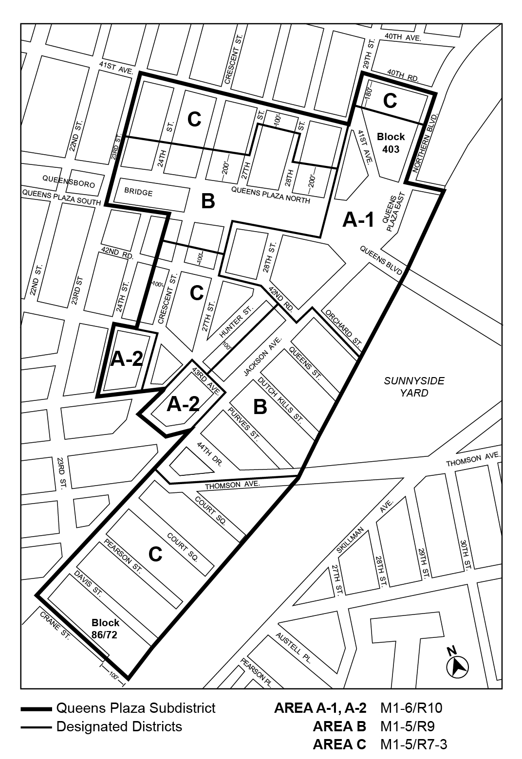
For the purposes of this Chapter, in the Queens Plaza Subdistrict, the area referred to as the "Sunnyside Yard" shall include: Yard A, the Arch Street Yard and the Sunnyside Yard, which are located generally between Crane Street, Jackson Avenue, 21st Street, 49th Avenue, Skillman Avenue, 43rd Street and the North Railroad property line.
Queens Plaza Subdistrict Plan
The Queens Plaza Subdistrict Plan partly consists of the following three maps located within Appendix E of this Chapter:
Map 1 (Designated Districts within the Queens Plaza Subdistrict) of the Queens Plaza Subdistrict Plan identifies special areas comprising the Queens Plaza Subdistrict in which an M1 District is paired with a Residence District as indicated on the Subdistrict Map. These areas are as follows:
| Area | Designated Districts |
| A-1 A-2 | M1-6/R10 |
| B | M1-5/R9 |
| C | M1-5/R7-3 |
Map 2 (Ground Floor Use and Frontage) of the Queens Plaza Subdistrict Plan specifies locations where the special ground floor use and frontage regulations, as set forth in Section 117-512, apply.
Map 3 (Sidewalk Widening and Street Wall Location) of the Queens Plaza Subdistrict Plan specifies the locations where special street wall and mandatory sidewalk widening regulations, as set forth in Section 117-531, apply.
Definitions
Definitions specifically applicable to the Queens Plaza Subdistrict of the Special Long Island City Mixed Use District are set forth in this Section. Other defined terms are set forth in Section 117-01 (Definitions) of the Special Long Island City Mixed Use District and Section 12-10 (DEFINITIONS).
Accessory use
In addition to those accessory uses listed in Section 12-10, for the purposes of this Section, an accessory use shall also include a dwelling unit in connection with any commercial, manufacturing or community facility establishment permitted in the Queens Plaza Subdistrict of the Special Long Island City Mixed Use District, pursuant to Section 117-51 (Queens Plaza Subdistrict Special Use Regulations), provided that no more than one such unit shall be permitted in connection with any establishment, and provided further that each such unit shall not exceed a gross area of 1,200 square feet or contain more than one kitchen.
Home occupation
Within the Queens Plaza Subdistrict, the home occupation provisions of Section 12-10 shall apply, except that a home occupation may occupy more than 1,000 square feet of floor area and up to three persons not residing in the dwelling unit or rooming unit may be employed.
The use regulations of the underlying districts shall apply, except where modified by the provisions of this Section, inclusive.
Large retail establishments
The underlying M1 District use regulations shall be modified such that uses listed under Use Group VI with a size limitation, as denoted with an “S” in the Use Group tables set forth in Section 42-16 (Use Group VI – Retail and Services), shall be permitted without a size limitation.
Streetscape regulations
The underlying ground floor level streetscape provisions set forth in Section 32-30 (STREETSCAPE REGULATIONS), inclusive, shall apply, except that ground floor level street frontages along streets, or portions thereof, designated on Map 2 in Appendix E of this Chapter shall be considered Tier C street frontages.
Special sign regulations
Within the Queens Plaza Subdistrict, the sign regulations of Section 123-40 shall apply, except that such sign regulations may be modified to permit a non-flashing sign on the rooftop of a non-residential building, provided that such sign directs attention to a business conducted within such building, where such business occupies at least 20 percent of the floor area within such building, or a minimum of 50,000 square feet of floor area within such building, whichever is less. In addition, the following rules shall apply:
- such sign shall be located on the rooftop of a building with frontage on Queens Plaza South, Queens Boulevard, Queens Plaza East or Queens Plaza North, and the height of the rooftop on which the sign is affixed shall be at least 70 feet but not more than 150 feet above curb level;
- there shall be no more than one such sign on a zoning lot, and no more than one such sign per establishment on any sign structure;
- such signs shall be affixed to an open frame structure with maximum dimensions that shall not exceed 45 feet in height, as measured from the surface of the roof to its uppermost point, and 150 feet in width, as measured along its widest dimension;
- all writing, pictorial representations, emblems, flags, symbols or any other figure or character comprising the design of such sign shall be separate elements, individually cut and separately affixed to the open frame structure. No perimeter or background surfaces shall be applied or affixed to the open frame structure in addition to such separate elements. No portion of such separate elements shall extend beyond the maximum dimensions allowed for an open frame structure. The area of such separate elements of a rooftop sign shall not count towards the maximum surface area of a sign permitted in Section 32-644 (Illuminated or flashing signs in C4, C5-4, C6 or C7 Districts); and
- any illumination from a rooftop sign located within 100 feet of any building containing residences, where such residences legally existed at the time of the application for a permit for such sign, shall not project into or reflect onto any residential portion of such building.
The bulk regulations of the underlying districts shall apply, except as modified by the provisions this Section, inclusive.
Floor area regulations
The maximum floor area ratio permitted for commercial, community facility, manufacturing or residential uses, separately or in combination, is specified in the following table:
MAXIMUM FLOOR AREA RATIO FOR ALL USES
|
Area |
Maximum Floor Area Ratio |
|
A-1 A-2 |
12.0 C, M, CF or R |
|
B |
8.0 C, M, CF or R |
|
C |
5.0 C, M, CF or R |
C=Commercial
M=Manufacturing
CF=Community Facility
R=Residential
However, for qualifying affordable housing or qualifying senior housing, the maximum residential floor area ratio shall be 9.6 in Area B, and 6.0 in Area C.
Floor area bonuses
Any floor area bonus for a public plaza or arcade permitted under the regulations of the designated Residence or M1 District shall not apply in the Queens Plaza Subdistrict.
For developments or enlargements on qualifying transit improvement sites, a floor area bonus for mass transit station improvements may be granted by the City Planning Commission pursuant to the provisions of Section 66-51 (Additional Floor Area for Mass Transit Station Improvements). For the purposes of this paragraph, defined terms additionally include those in Section 66-11 (Definitions).
Special yard regulations
The yard regulations of the underlying districts shall apply, except as specified in this Section.
(a) Manufacturing or commercial buildings
The rear yard provisions of the designated M1 District shall not apply to manufacturing or commercial buildings on through lots.
(b) Zoning lots adjacent to the Sunnyside Yard
On a zoning lot sharing a lot line with the Sunnyside Yard, no yards are required for any building within a distance of 100 feet from the shared lot line.
(c) For zoning lots occupying an entire block
No rear yard or rear yard equivalent shall be required for a zoning lot occupying an entire block.
The height and setback regulations of the designated Residence and M1 Districts shall not apply, except for permitted obstructions pursuant to Sections 23-41 or 43-42, as applicable. In lieu thereof, all buildings or other structures shall comply with the regulations set forth in Sections 117-531 (Street wall location) and 117-532 (Setback regulations for buildings that exceed the maximum base height). Such regulations, however, shall not apply along the street frontage of that portion of a zoning lot occupied by existing buildings, unless the street walls of such existing buildings are vertically extended by more than 15 feet. The height of all buildings or other structures shall be measured from the base plane.
Street wall location
(a) On a wide street, and on a narrow street within 50 feet of its intersection with a wide street, the street wall provisions of paragraph (a) of Section 35-631 (Street wall location) shall apply, except that the street wall shall extend to at least the applicable minimum base height specified in the table in Section 117-532 (Setback regulations for buildings that exceed the maximum base height), or the height of the building, whichever is less.
(b) On a narrow street between 50 and 100 feet of its intersection with a wide street, the street wall location provisions of paragraph (b) of Section 35-631 shall apply, except that the street wall shall extend along the entire width of the narrow street frontage
Beyond 100 feet of the intersection of a wide street, the street wall location provisions of paragraph (b) of Section 35-631 shall apply.
(c) In the locations specified on Map 3 (Sidewalk Widening and Street Wall Location) in Appendix E of this Chapter, a building shall comply with the provisions of paragraphs (a) and (b) of this Section, as applicable, except that street walls shall be located as specified on Map 3. The street wall of a building may be set back only in the areas indicated on Map 3 as "Permitted Street Wall Setback Locations," provided that the additional sidewalk widening resulting from such setback is accessible to the public, in accordance with the provisions of Section 117-553 (Mandatory sidewalk widening design requirements), and located adjacent to a public sidewalk or mandatory sidewalk widening.
(d) For any building fronting on Queens Plaza South in Area A-1 or Area B, as shown on Map 1 (Designated Districts within the Queens Plaza Subdistrict) of Appendix E, any street wall along Queens Plaza South shall be set back five feet from the street line, except as otherwise specified on Map 3.
(e) For any building on a zoning lot located on Jackson Avenue between 42nd Road and Queens Plaza South, the street wall fronting on Jackson Avenue may be set back five feet from the street line only upon certification of the Chairperson of the City Planning Commission to the Department of Buildings that the Jackson Avenue sidewalk adjacent to the zoning lot will be landscaped in accordance with a plan acceptable to the Department of Transportation and the Chairperson. Such plan shall include five planting beds that shall contain a mixture of deciduous and evergreen shrubs, ground covers and flowers. Such planting beds shall be installed and maintained by the owner of the building. The street wall of any subsequent development or enlargement shall be located no closer to nor further from the street line than the street wall of an adjacent existing building.
All portions of buildings or other structures that exceed the maximum base height specified in the table in this Section shall comply with the following provisions:
(a) At a height not lower than the minimum base height or higher than the maximum base height specified in the table for the applicable area, a setback with a depth of at least 10 feet shall be provided from any street wall fronting on a wide street and a setback with a depth of at least 15 feet shall be provided from any street wall fronting on a narrow street. Such setback may be modified in accordance with the provisions of Section 23-433 (Standard setback regulations).
|
Area |
Minimum Base Height |
Maximum Base Height |
|
A-1 |
60 |
--- |
|
A-2 |
60 |
150 |
|
B |
100 |
150 |
|
C* |
60 |
100 |
______
* for buildings or other structures on Davis Street located 75 feet or more from Jackson Avenue, the minimum base height shall be 40 feet
(b) In Area A-1, no setbacks are required above the applicable minimum base height specified in the table in paragraph (a) of this Section. However, if a setback is provided, it shall comply with the provisions of paragraph (a).
For any zoning lot within the Queens Plaza Subdistrict of the Special Long Island City Mixed Use District, the City Planning Commission may permit modification of the use or bulk regulations, except floor area ratio requirements, provided the Commission shall find that:
(a) such use or bulk modification will aid in achieving the general purposes and intent of the Special District;
(b) such use modification will encourage a lively pedestrian environment along the street or mandatory sidewalk widening, or is necessary for the programmatic requirements of the development;
(c) such bulk modifications will enhance the distribution of bulk on the zoning lot;
(d) such bulk modifications will permit adequate access of light and air to surrounding streets and properties; and
(e) such use or bulk modification will relate harmoniously to the character of the surrounding area.
The Commission may prescribe appropriate conditions and safeguards to minimize adverse effects on the character of the surrounding area.
- The off-street parking provisions of Article I, Chapter 6, shall be modified as follows:
- the prohibition of curb cuts accessing entrances and exits to accessory off-street parking facilities and public parking garages on certain streets, as set forth in paragraphs (b) and (c) of Section 16-23 (Curb Cut Restrictions), shall also apply to Northern Boulevard and Crescent Street; and
- the provisions of paragraph (c) of Section 16-12 (Permitted Parking for Non-residential Uses) shall be modified as follows: the maximum number of accessory off-street parking spaces permitted for a development or enlargement shall not exceed one space per 2,000 square feet of floor area or 250 spaces, whichever is less.
- Curb cuts shall not be permitted within 40 feet of a zoning lot line that abuts the Sunnyside Yard.
- Public parking garages shall be permitted on Blocks 86/72 and 403 pursuant to Section 117-56 (Special Permit for Bulk Modifications on Blocks 86/72 and 403).
General provisions
Mandatory sidewalk widening
The sidewalk widening provisions of this Section shall apply to all developments or enlargements with ground floor street walls with a ratio of floor area to lot area of 3.0 or more.
Sidewalk widening accessible to the public must be provided in the locations specified on Map 3 (Sidewalk Widening and Street Wall Location) in Appendix E of this Chapter. Such mandatory sidewalk widening is subject to the design requirements of Section 117-553 (Mandatory sidewalk widening design requirements).
(a) Access
All mandatory sidewalk widenings shall be accessible directly from an adjoining public sidewalk and unobstructed along at least 50 percent of the total street frontage. Driveways and vehicular accessways included as part of the total street frontage may not be counted as providing access. All mandatory sidewalk widenings shall be accessible to the public at all times.
There shall be at least one unobstructed pedestrian path of travel providing access to each of the following:
(1) at least 70 percent of the mandatory sidewalk widening's total area;
(2) any building lobby accessible to the mandatory sidewalk widening; and
(3) any use that may be present on, or adjacent to and having an entrance on, the mandatory sidewalk widening.
(b) Access for persons with disabilities
The mandatory sidewalk widening shall be accessible to persons with disabilities in accordance with the Americans with Disabilities Act and the American National Standards Institute (ANSI) design standards.
(c) Elevation
All mandatory sidewalk widenings shall be located at an elevation not more than three feet above or below the curb level of the nearest adjoining sidewalk.
A mandatory sidewalk widening shall be at the same elevation as the adjoining public sidewalk along the street frontage providing access, pursuant to paragraph (a) of this Section, for a minimum depth of 10 feet measured perpendicular to the street line.
When the size of a mandatory sidewalk widening is 8,000 square feet or more, a maximum of 25 percent of its area may be located at an elevation more than three feet above or below the nearest adjoining sidewalk, which area, however, may not be located within a depth of 10 feet from the sidewalk measured perpendicular to the street line.
Where an existing subway station entry is located on the sidewalk area adjacent to a mandatory sidewalk widening, the mandatory sidewalk widening shall be provided at the same elevation as the adjoining sidewalk for a distance of at least 15 feet in all directions from the entry except as required for drainage. No obstruction shall be permitted within such portion of the mandatory sidewalk widening.
(d) Permitted obstructions
The provisions of Sections 37-726 and 37-73 shall apply, except that in the case of kiosks, the provisions of Section 37-73 shall be modified as follows: the aggregate area occupied by such kiosks shall not exceed 60 square feet or 1.5 percent of the area occupied by the sidewalk widening.
(e) Driveways, parking spaces, loading berths, exhaust vents and building trash storage facilities
The provisions of Section 37-726, paragraph (d), shall apply.
(f) Trees
One tree per 500 square feet of sidewalk widening is required. Each tree shall measure at least 2.5 inches in caliper at the time of planting. Each tree shall be planted in at least 200 cubic feet of soil with a depth of at least 3 feet, 6 inches.
(g) Paving
The provisions of Section 37-718 shall apply.
(h) Seating
One linear foot of seating for every 150 square feet of mandatory sidewalk widening shall be provided. In addition, the provisions of Section 62-672 shall apply.
(i) Bicycle parking facilities
The provisions of Section 37-745 shall apply.
(j) Drinking fountains
The provisions of Section 37-746 shall apply.
(k) Aesthetic amenities
One of the following amenities shall be provided:
(1) prominent lighting that enhances the architectural features of the upper stories of the building;
(2) an ornamental water feature within the mandatory sidewalk widening; or
(3) artwork, such as sculpture, within the mandatory sidewalk widening.
(l) Lighting
The provisions of Section 37-743 shall apply, except that the minimum level of illumination shall be not less than two horizontal foot candles throughout the entire mandatory sidewalk widening.
(m) Sidewalk widening signs
The provisions of Section 37-751, paragraph (b) shall apply.
(n) Maintenance
The provisions of Sections 37-744 and 37-77 shall apply.
For any development or enlargement on a zoning lot that has at least 50,000 square feet of lot area located on Block 86/72 or Block 403 in Area C as shown on Map 1 (Designated Districts within the Queens Plaza Subdistrict) in Appendix E of this Chapter, the City Planning Commission may increase the floor area ratio up to a maximum of 8.0 and may modify the street wall regulations of paragraphs (a) and (b) of Section 117-531 (Street wall location) and paragraph (a) of Section 117-532 (Setback regulations for buildings that exceed the maximum base height), provided that:
(a) a public open area of not less than 20,000 square feet and a public parking garage containing no fewer than 250 spaces shall be included on the zoning lot, and further provided the Commission finds that:
(1) the public open area is designed so that it provides recreational opportunities for the community;
(2) the portion of the development or enlargement adjacent to the public open area shall be either a retail use, other use or treatment that complements the open area;
(3) such modification of the street wall requirements is necessary to accommodate the public open area or the public parking garage and will result in a better site plan;
(4) the public parking garage is located and designed in such a way so that it shall not adversely affect the quality of the design, access to, or use of the public open area; and
(5) where the Commission permits parking on the roof of such public parking garage, such roof parking shall be so located as not to impair the essential character or future use or development of adjacent areas.
Design elements of the open area including lighting, paving, seating, signs and planting areas shall be specified in the application. The provisions of Section 37-751 (Public space signage systems) and 37-77 (Maintenance) shall apply.
(b) The public parking garage shall be subject to the following conditions:
(1) the floor space on one or more stories of the public parking garage, up to a height of 23 feet above curb level shall be exempt from the definition of floor area as set forth in Section 12-10 (DEFINITIONS);
(2) the entrances and exits shall be located so that they will not be hazardous to traffic safety nor likely to unduly inhibit pedestrian movement; and
(3) at the vehicular entrances, a minimum of 12 reservoir spaces shall be provided and the total number of reservoir spaces shall be equivalent to five percent of any spaces in excess of 250, up to a maximum of 50 reservoir spaces.
The Commission may prescribe appropriate conditions and safeguards to minimize adverse effects on the character of the surrounding area, including requirements for sanitation and security, which may include conditions for lighting and landscaping or limitations on the manner and/or hours of operation.
Any building on Block 86/72 for which an application for a special permit for bulk modifications has been filed with the Department of City Planning, pursuant to this Section, prior to May 22, 2013, may be started or continued pursuant to the regulations in effect at the time of such application and, if such application is granted by the City Planning Commission and the City Council, may be developed or enlarged pursuant to the terms of such permit, including minor modifications thereto and, to the extent not modified under the terms of such permit, in accordance with the regulations in effect at the time of such application.
In Article V, Chapter 4 (Non-complying Buildings), Section 54-311 (Buildings containing rooming units) shall not apply.
DUTCH KILLS SUBDISTRICT
In the Special Long Island City Mixed Use District, the special regulations of Section 117-60, inclusive, shall apply within the Dutch Kills Subdistrict.
General Provisions
In the Dutch Kills Subdistrict, the use, #bulk, and parking regulations of the underlying districts shall apply, except as modified by the provisions of Section 117-60, inclusive.
Special Use Regulations
In the Dutch Kills Subdistrict, uses listed under Food and Beverage Retailers in Use Group VI shall be permitted without a size limitation.
Floor area ratio modifications
- Floor space used for accessory off-street parking spaces
In the Dutch Kills Subdistrict, the floor area of a building shall not include floor space used for accessory off-street parking spaces provided in any story located not more than 33 feet above curb level, in any building, except where such floor space used for accessory parking is contained within a public parking garage. - Maximum floor area ratio for residential uses
In M1 Districts paired with R5B Districts, the regulations for qualifying residential sites shall not apply, and the maximum residential floor area ratio shall be 1.65. - Maximum floor area ratio for certain commercial and manufacturing uses
In M1-2 designated districts, the maximum floor area ratio shall be increased to 3.0 when paired with an R5B or R5D District and 4.0 when paired with an R6A District, provided that such additional floor area is limited to referenced commercial and manufacturing uses. - Maximum floor area in mixed use buildings
In M1 Districts paired with R5B or R5D districts, the regulations for qualifying residential sites shall not apply to mixed use buildings.
Street wall location
In the Dutch Kills Subdistrict, the street wall location provisions of paragraph (a) of Section 23-431 shall apply.
Special Parking Regulations
The provisions of Section 123-70 (PARKING AND LOADING) and the underlying accessory off-street parking and loading regulations for the designated district are modified, as follows:
- Commercial and community facility uses
- The accessory off-street parking and loading requirements of a C8-2 District, as set forth in Article III, Chapter 6, shall apply to all commercial and community facility uses, except that this modification shall not apply to uses listed in Use Group V. The accessory off-street parking and loading requirements applicable to the designated M1 District, set forth in Article IV, Chapter 4, and Section 123-70, shall apply to Use Group V.
- For Use Group V uses, the provisions of Section 44-232 (Waiver of Requirements for Spaces Below Minimum Number) shall be modified as follows: the maximum number of accessory off-street parking spaces for which requirements are waived shall be five spaces.
- Residential uses
Where the designated district is an M1-2/R5B District, the provisions of paragraph (c) of Section 25-631 (Location and width of curb cuts in certain districts) shall not apply.

Appendix B
Queens Plaza West Subdistrict Plan Map
(11/12/25)
Map 1: Subdistrict Plan Map and Streetscape Regulations
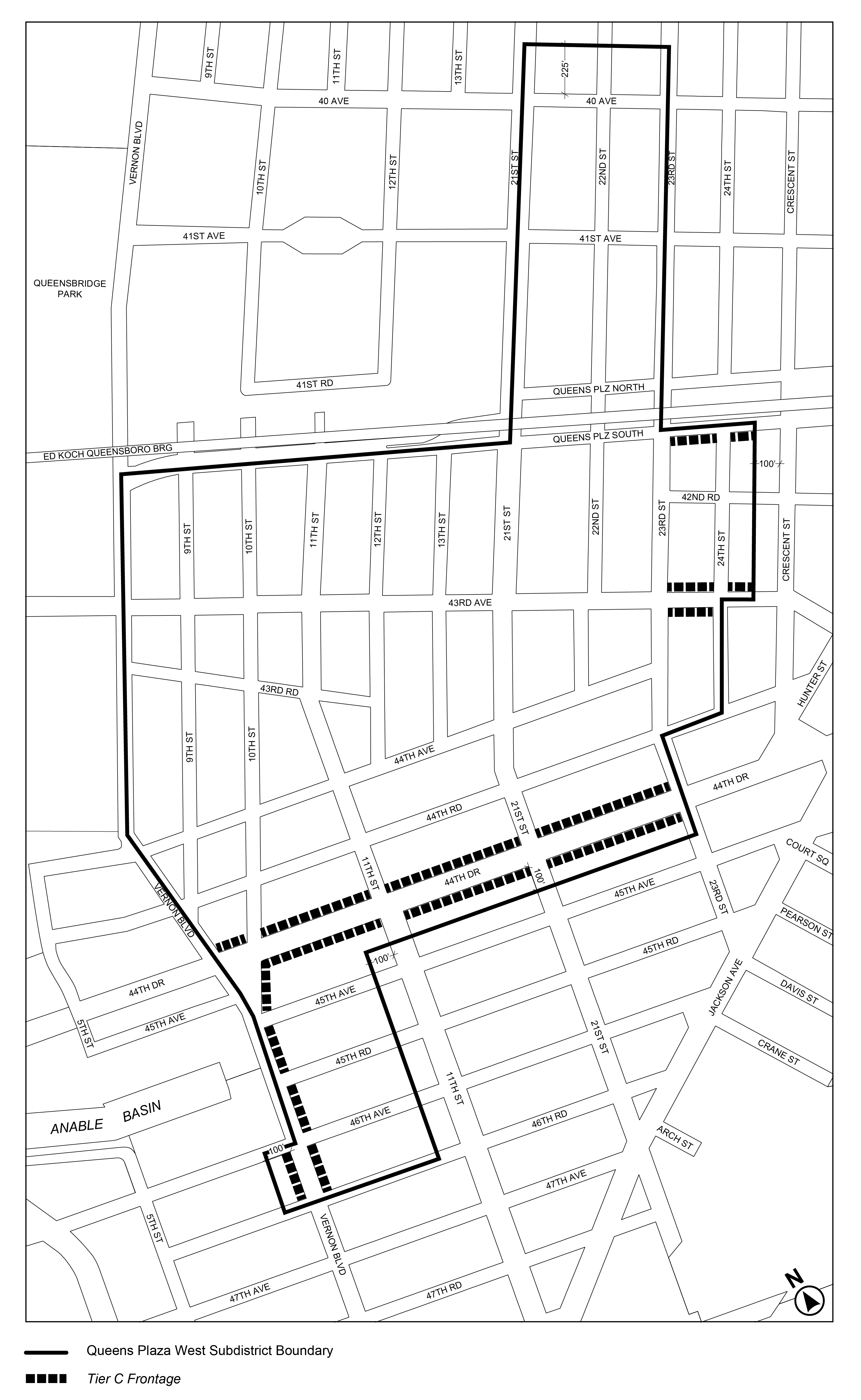
Appendix C
Northern Hunters Point Waterfront Subdistrict Plan Maps
(11/12/25)
Map 1: Subdistrict Plan Map and Designated Subareas
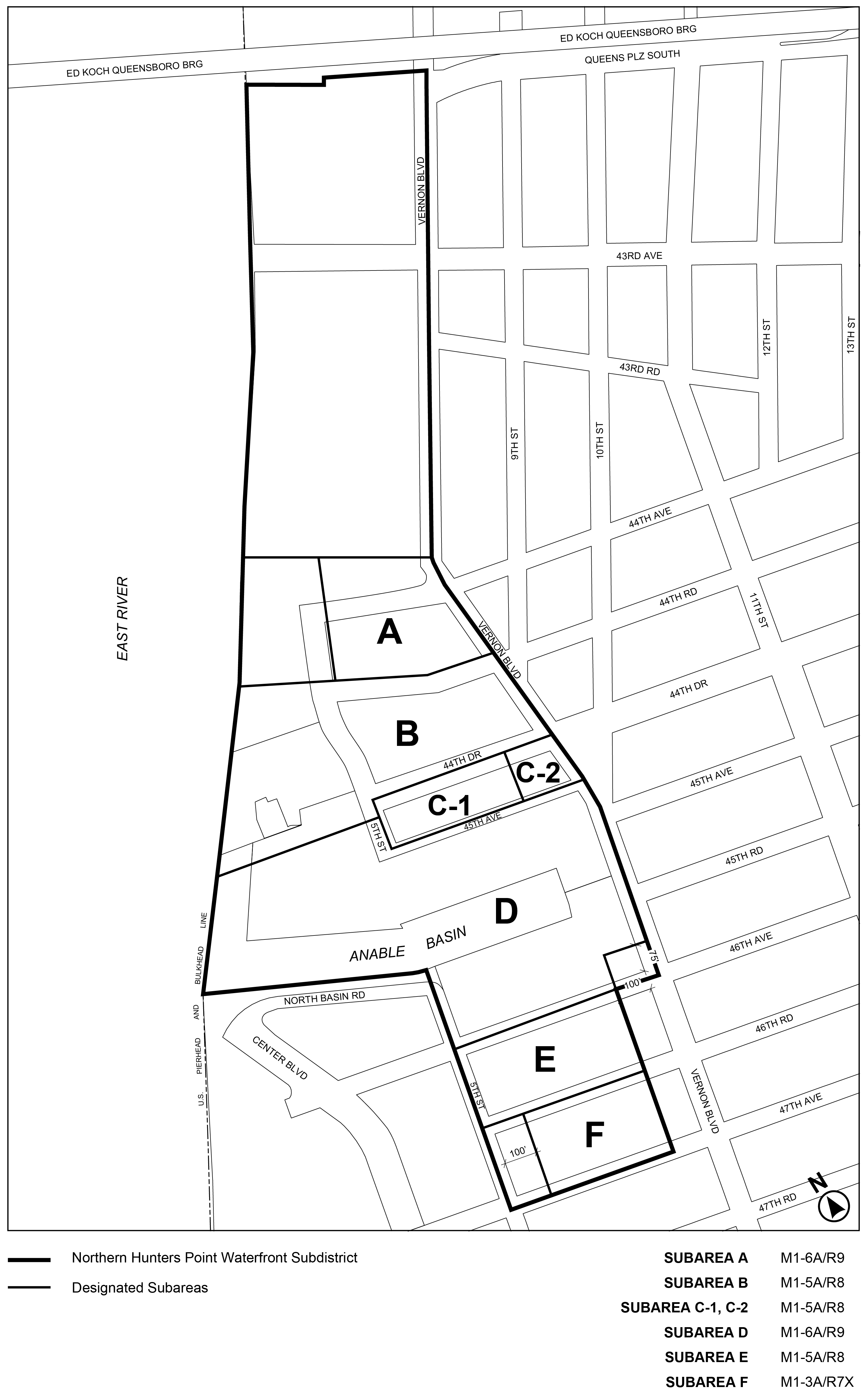
(11/12/25)
Map 2: Streetscape Regulations Designation
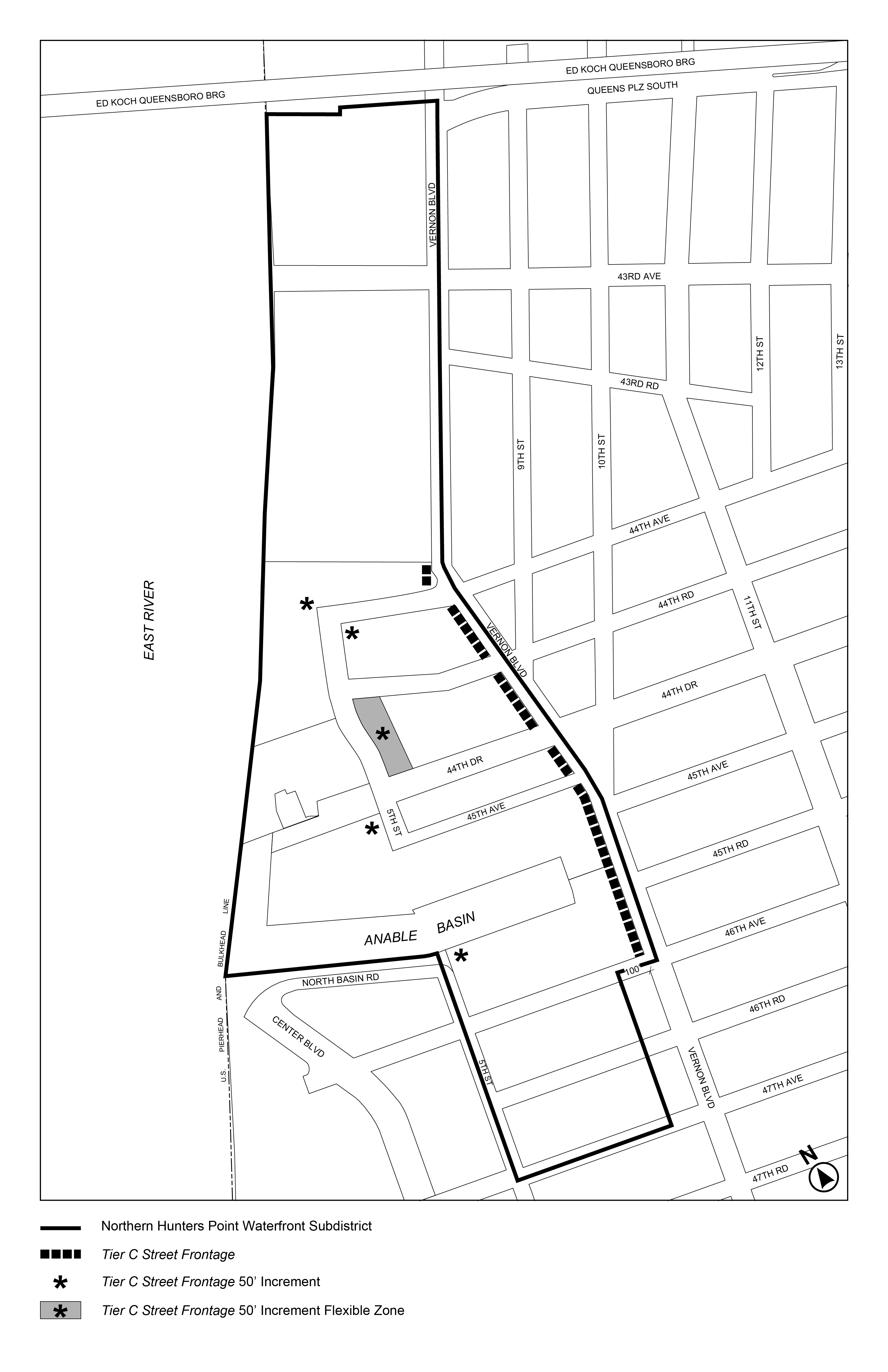
(11/12/25)
Map 3: Waterfront Access Plan Parcels Designation
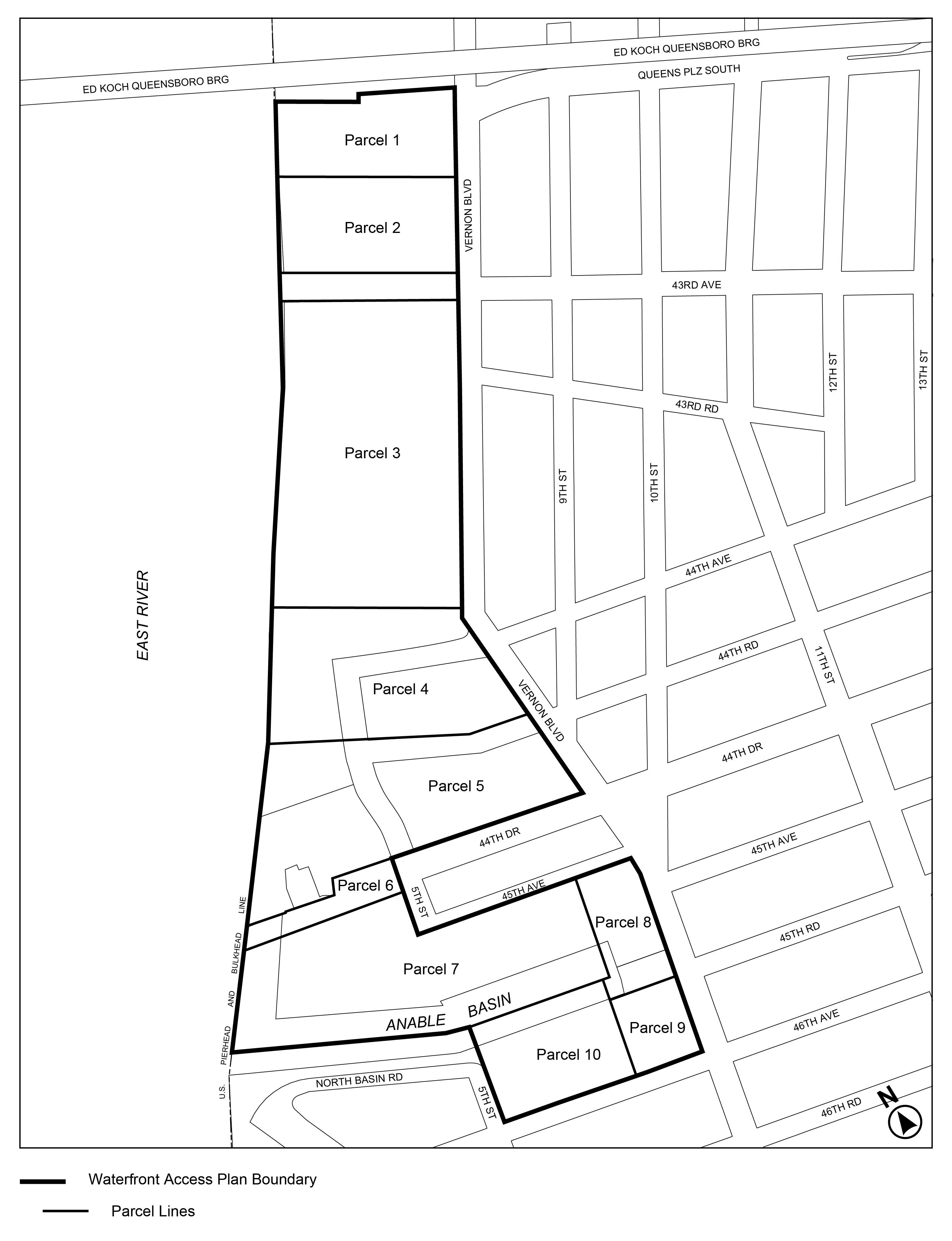
(11/12/25)
Map 4: Public Access Elements Designation
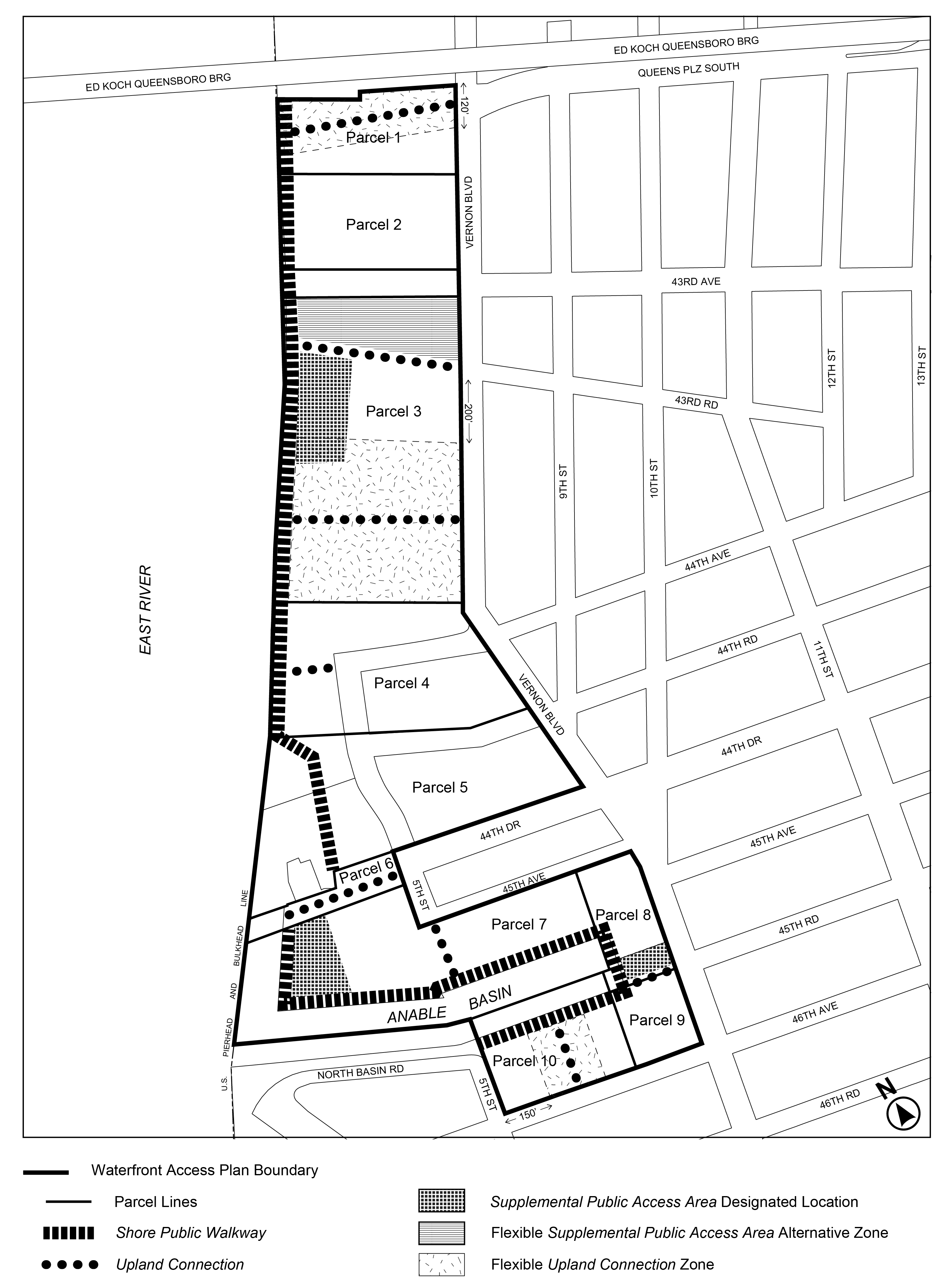
(11/12/25)
Map 5: Visual Corridors Designation
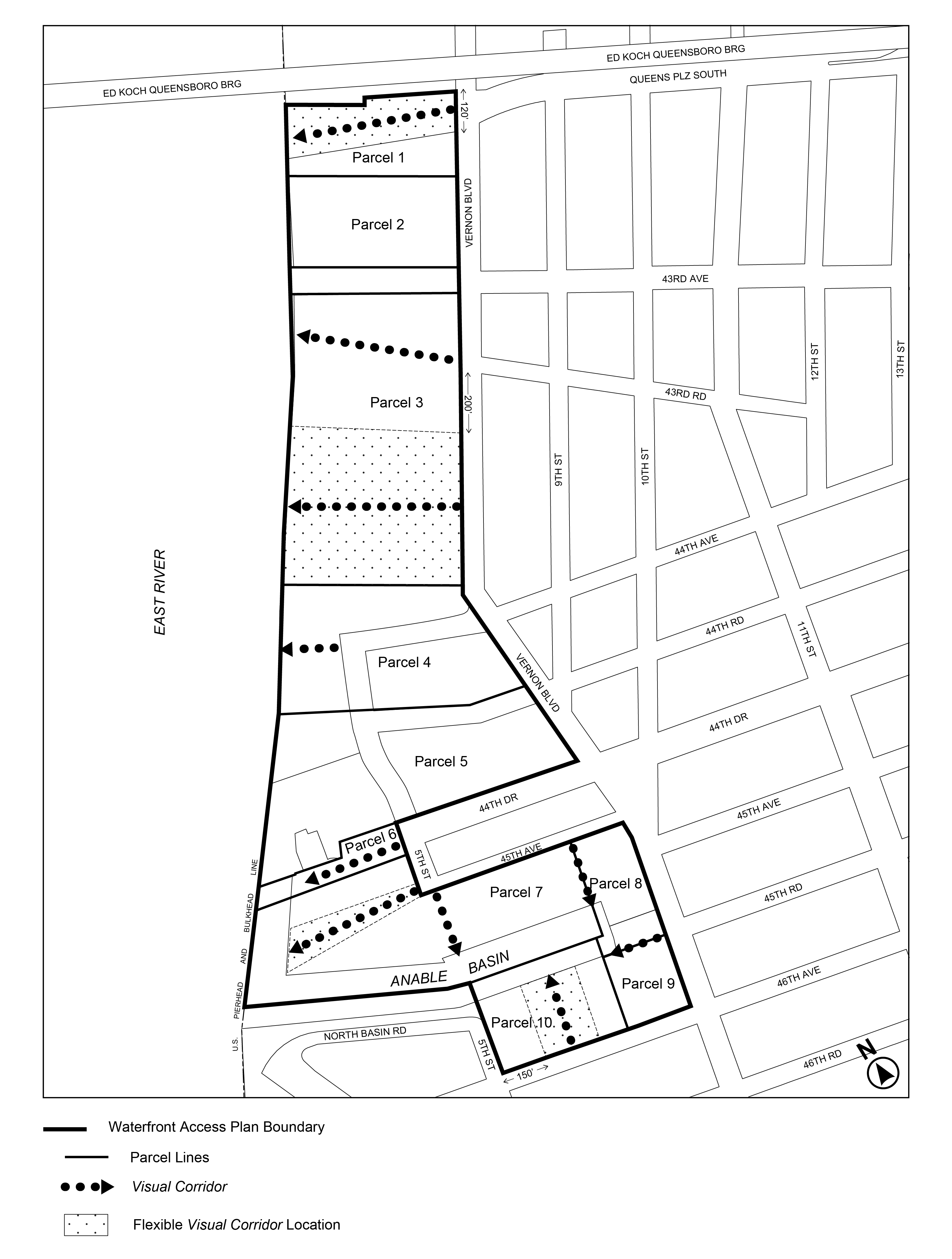
Appendix D
Court Square Subdistrict Plan Map and Description of Improvements
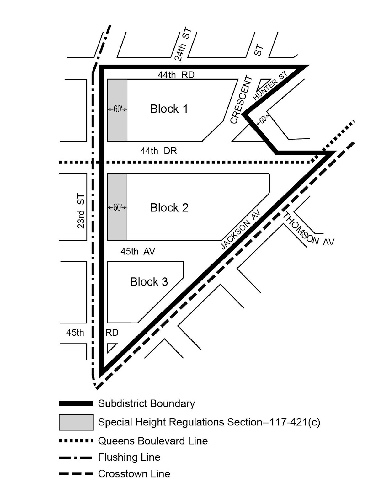
Description of Improvements
This Appendix describes the mandatory lot improvements that are designated on the District Plan Map in Appendix B for the Court Square Subdistrict. Descriptions refer to the text for requirements and standards for the following improvements.
(a) Block 1
A subway improvement, to consist of a connection between the Crosstown and Flushing Lines and maintenance of glass partitions in the control area of the Queens Boulevard Line, Court Sq-23 St Station mezzanine and near the control area of the Crosstown Line, Court Sq Station mezzanine which are to be installed by the developer of Block 2. The developer shall notify the Chairperson of the City Planning Commission upon both application for, and issuance of, a first building permit for the development on this Block.
(b) Block 2
A subway improvement, to consist of a connection between the Queens Boulevard and Crosstown Lines, preparation of preliminary plans for a Crosstown Line, Court Sq Station and Flushing Line, Court Sq Station connection and installation of glass partitions in the control area of the Court Sq-23 St Station mezzanine and near the control area of the Court Sq Station mezzanine, upon receipt of a written request by the Chairperson of the City Planning Commission, which shall occur only after the issuance of a first building permit for the development on Block 1.
(c) Block 3
(1) The first development or enlargement to meet the criteria for a subway improvement shall construct new entrances at the intersection of 44th Drive and 23rd Street for the Flushing Line, Court Sq Station, in consultation with the Metropolitan Transportation Authority and the Department of City Planning.
(2) For subsequent developments or enlargements, a subway improvement to the north end of the Flushing Line, Court Sq Station, shall be required. Such improvement shall be determined in consultation with the Metropolitan Transportation Authority and the Department of City Planning.