Chapter 4 - Special Brooklyn Navy Yard District (BNY)
GENERAL PURPOSES
The “Special Brooklyn Navy Yard District” established in this Resolution is designed to promote and protect public health, safety and general welfare. These goals include, among others, the following specific purposes:
(a) to encourage investment in the Brooklyn Navy Yard and facilitate the expansion of the Brooklyn Navy Yard as a modern manufacturing complex;
(b) to promote job growth;
(c) to allow for a mix of office, community facility, retail, and other commercial uses to complement the industrial and manufacturing facilities at the Brooklyn Navy Yard;
(d) to use traffic management planning to meet loading and parking needs including through alternate means of travel;
(e) to better integrate the Brooklyn Navy Yard with the urban fabric of surrounding residential and mixed-use communities and to introduce publicly accessible open space areas within the perimeter of the Yard; and
(f) to promote the most desirable use of land in accordance with a well-considered plan and thus conserve the value of land and buildings, and thereby protect the City’s tax revenues.
Definitions
Definitions specifically applicable to this Chapter are set forth in this Section and may modify definitions set forth in Section 12-10 (DEFINITIONS). Where a term in italics is defined in both Section 12-10 and in this Chapter, the definitions in this Chapter shall govern. The terms pier, platform, and floating structure shall have the meaning set forth in Section 62-11 (Definitions).
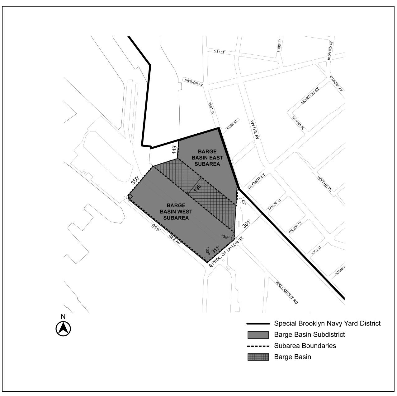
Barge Basin
“Barge Basin” shall mean that inlet from the East River identified on Map 2 in the Appendix to this Chapter as the Barge Basin.
Shoreline
The definition of shoreline set forth in Section 12-10 is modified for the purposes of this Chapter to mean the shoreline on a survey available on the Department of City Planning website.
General Provisions
The provisions of this Chapter shall apply within the Special Brooklyn Navy Yard District. The regulations of all other Chapters of this Resolution are applicable, except as superseded, supplemented, or modified by the provisions of this Chapter. In the event of a conflict between the provisions of this Chapter and other regulations of this Resolution, the provisions of this Chapter shall control. However, in flood zones, in the event of a conflict between the provisions of this Chapter and the provisions of Article VI, Chapter 4 (Special Regulations Applying in Flood Zones), the provisions of Article VI, Chapter 4 shall control.
District Plan and Maps
The regulations of this Chapter are designed to implement the Special Brooklyn Navy Yard District Plan. The district plan includes the following maps in the Appendix to this Chapter:
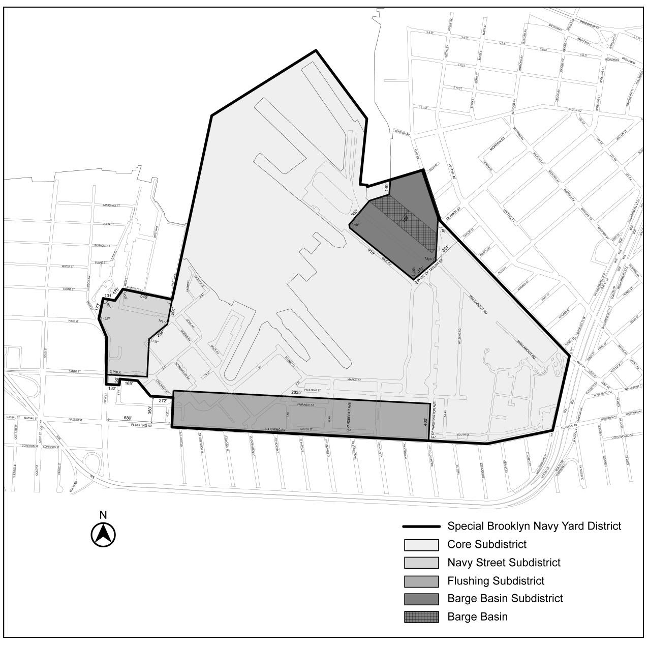
Map 1 Special Brooklyn Navy Yard District and Subdistricts
Map 2 Barge Basin Subareas
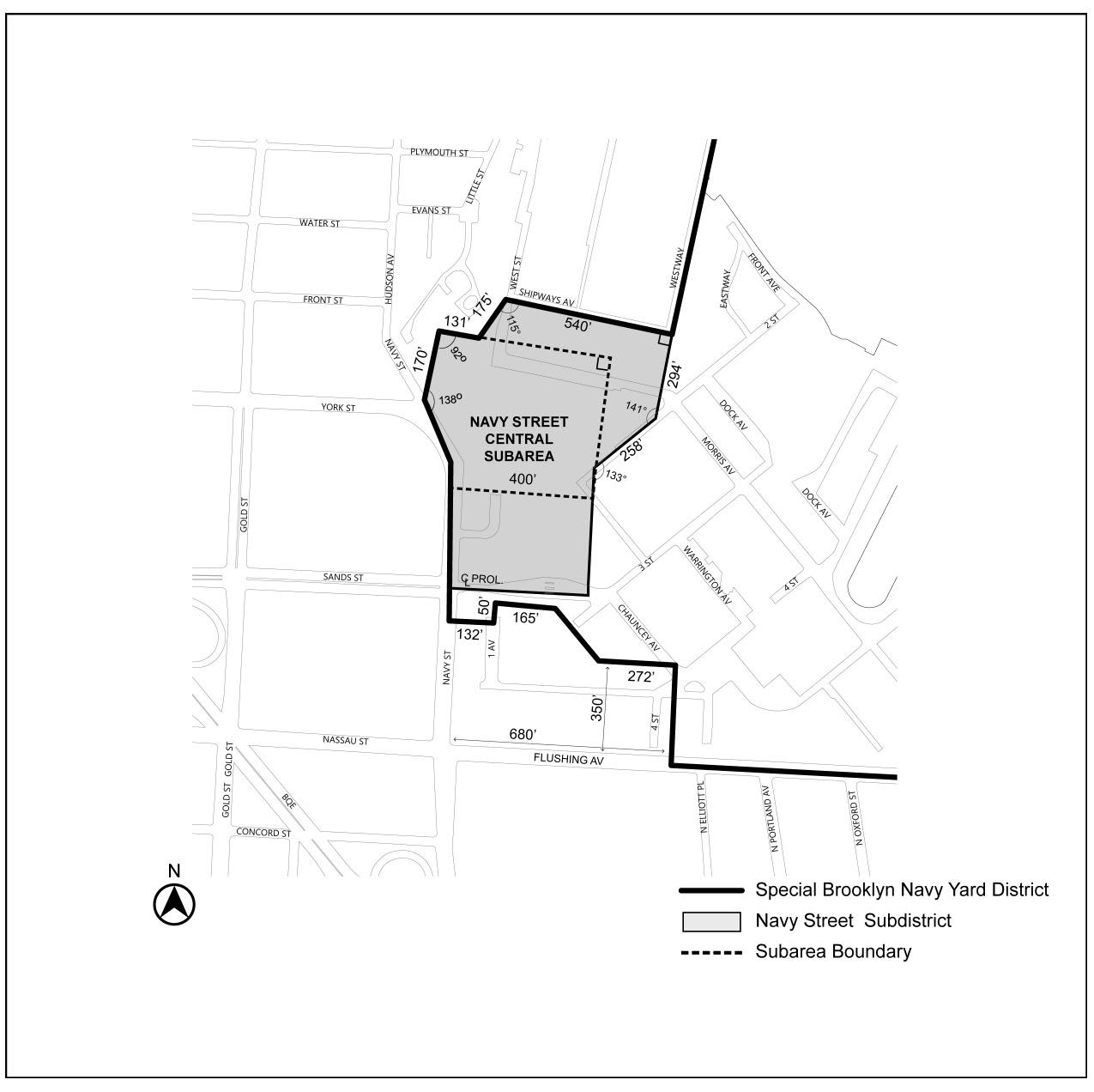
Map 3 Navy Street Central Subarea
Map 4 Flushing Avenue Subareas and View Corridors
Map 5 Street Line Locations in the Barge Basin Subdistrict
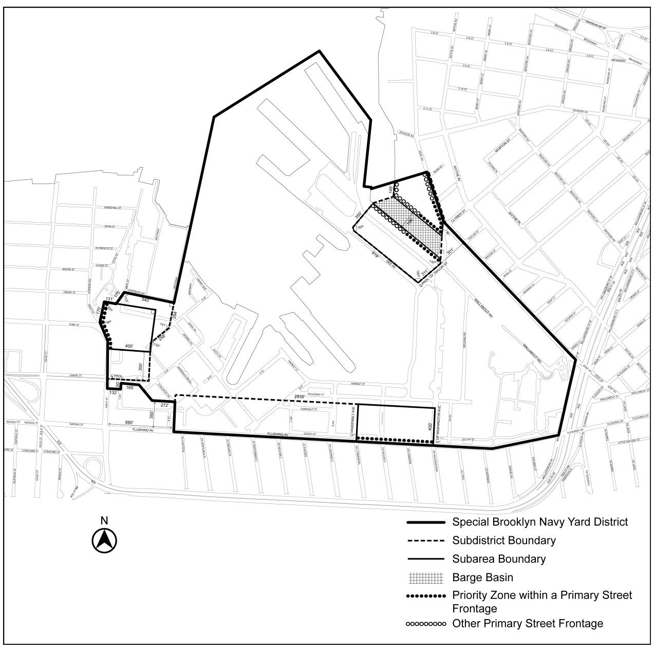
Map 6 Primary Street Frontages
The maps are hereby incorporated and made part of this Resolution for the purpose of specifying locations where the special regulations and requirements set forth in the text of this Chapter apply.
Subdistricts and Subareas
In order to carry out the purposes and provisions of this Chapter, four subdistricts are established within the Special Brooklyn Navy Yard District comprised of three perimeter subdistricts and one core subdistrict for the remainder of the Yard. In addition, one subarea is established within the Navy Street Subdistrict, two subareas are established within the Flushing Subdistrict and two subareas are established within the Barge Basin Subdistrict.
Perimeter Subdistricts
Navy Street Subdistrict
Navy Street Central Subarea
Flushing Subdistrict
Flushing West Subarea
Flushing East Subarea
Barge Basin Subdistrict
Barge Basin East Subarea
Barge Basin West Subarea
Core Subdistrict
The boundaries of the Subdistricts are shown in Map 1 and the boundaries of the Subareas are shown on Maps 2 through 4 in the Appendix to this Chapter.
The provisions of Article VI, Chapter 2 (Special Regulations Applying in the Waterfront Area) shall not apply in the Special Brooklyn Navy Yard District except as expressly provided in this Chapter.
Single Zoning Lot
For all purposes of this Chapter, the Special Brooklyn Navy Yard District shall be deemed to be a single zoning lot except where expressly provided otherwise in this Chapter. Floor area attributable to the zoning lot may be located anywhere on the zoning lot without regard to Subdistrict boundary lines, and all floor area located within a Subdistrict shall be subject to the use and bulk requirements of such Subdistrict.
SPECIAL USE REGULATIONS
Within the Special Brooklyn Navy Yard District, the use provisions of Article IV, Chapter 2 are modified by the provisions of this Section, inclusive.
In all districts, the underlying use regulations are modified as follows:
The provisions of Section 62-21 (Classification of Uses in the Waterfront Area), Section 62-22 (Commercial Docking Facilities), Section 62-24 (Uses on Piers and Platforms), and Section 62-25 (Uses on Floating Structures) shall apply, provided that all uses existing on piers and platforms as of December 15, 2021, shall be deemed conforming uses.
The provisions of Section 42-10 (USE ALLOWANCES) shall be modified to permit the following uses in M2-1 Districts, subject to the requirements of Section 144-213 (Floor area limitations on additional uses):
- all uses listed under Use Group III(B) shall be permitted; and
- all uses listed under Use Group VI shall be permitted, and where such uses have a size limitation, as denoted with an “S” in the Use Group tables set forth in Section 42-16 (Use Group VI – Retail and Services), such size limitation shall not apply.
Within M3-1 Districts, the City Planning Commission may allow, by authorization, schools, colleges or universities, without sleeping accommodations, as listed in Use Group 3A, provided that the Commission finds that:
(a) such school, college or university has an academic program compatible with a tenant or industrial operation in the Special Brooklyn Navy Yard District; and
(b) the location of the school, college or university will not interfere with any manufacturing use or alter the essential industrial character of the Special Brooklyn Navy Yard District.
The Commission may impose appropriate conditions and safeguards to minimize adverse impacts effects on the character of the surrounding area.
Special Sign Regulations
Illuminated non-flashing signage
The provisions of Section 42-633 (Illuminated or flashing signs) shall be modified to allow one accessory non-flashing illuminated sign to have a surface area of 750 square feet in each of the following Subareas: the Navy Street Central Subarea, the Flushing East Subarea, between Clinton Avenue and Washington Avenue, the Barge Basin East Subarea, and the Barge Basin West Subarea. All other illuminated signs shall comply with the requirements of Section 42-633.
The provisions of Section 42-66 (Special Provisions Applying Along District Boundaries) shall be modified as follows:
- within the Flushing East Subarea, the provisions of Section 42-661 (Restrictions along the district boundary located in a street) shall not apply to any sign provided in accordance with Section 144-141 (Illuminated non-flashing signage); and
- within the Navy Street Central Subarea, the Flushing East Subarea, and the Barge Basin Subdistrict, the orientation provisions of Section 42-662 (Restriction on angle and height above curb level) shall not apply to signs provided in accordance with Section 144-141.
SPECIAL BULK REGULATIONS
Within the Special Brooklyn Navy Yard District, the bulk provisions of Article IV, Chapter 3 are modified by the provisions of this Section, inclusive.
Floor Area Regulations
Floor area ratio
In all districts, the maximum floor area ratio for all uses shall be 2.0.
Floor area ratio calculations
For the purposes of calculating floor area on waterfront zoning lots, the provisions of Section 62-31 (Bulk Computations on Waterfront Zoning Lots) shall apply.
The additional uses allowed pursuant to Section 144-11 (Additional Uses Allowed in M2 Districts) shall be limited to 300,000 square feet of floor area within each Subdistrict where such additional uses are allowed, and the total floor area allocated to such additional commercial uses shall not exceed 100,000 square feet in each Subdistrict where the additional uses are allowed.
Yard and Shoreline Setback
The underlying yards regulations of Section 43-20 (YARD REGULATIONS), inclusive, and Section 43-31 (Other Special Provisions for Rear Yards) shall not apply. In lieu thereof, the provisions of this Section shall apply.
In all districts, no building shall be located closer to the shoreline than 30 feet, except for buildings used for water dependent uses, as set forth in Section 62-21 (Classification of Uses in the Waterfront Area), or buildings containing not more than 5,000 square feet of floor area.
The shoreline setback requirement shall be reduced in dimension, or eliminated, where the Chair of the City Planning Commission certifies to the Commissioner of the Department of Buildings or the Commissioner of the Department of Small Business Services, as applicable, that either:
(a) a building proposed to be located within such 30-foot setback area incorporates flood protection measures for the immediate area of the building that protect the building to a level that is 58 inches above the mean high water line existing on December 15, 2021; or
(b) a district-wide resiliency plan for the Special Brooklyn Navy Yard District has been adopted and the measures to be incorporated in connection with the development or already in place are in furtherance of the district-wide plan.
Measures shall be deemed protective if they alone or together with other measures in place at the time of construction protect the building from flooding to the elevation set forth in paragraph (a) of this Section or if they would support protection of the entire Special Brooklyn Navy Yard District to such elevation without further improvement of the portion of area directly seaward of the proposed building.
The Chairperson shall certify the application within 45 days of receipt of a complete application. Failure to certify within the 45-day period will release the Department of Buildings or the Department of Small Business Services from any obligation to withhold the excavation or building permit and authorize such agency to determine compliance with the provisions of this Section.
The underlying height and setback regulations of Section 43-40 (HEIGHT AND SETBACK REGULATIONS) are modified by the provisions of this Section, inclusive.
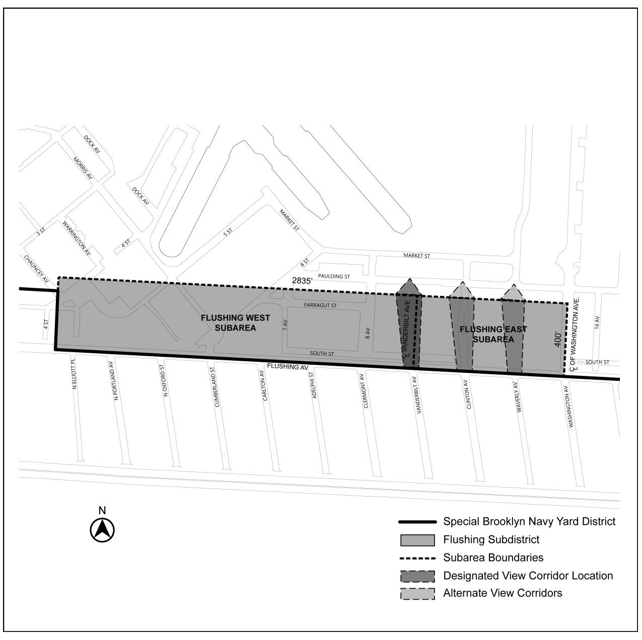
Flushing East Subarea
In the Flushing East Subarea, the following height and setback modifications shall apply:
(a) Wide street designation
For purposes of applying the height and setback controls, Flushing Avenue shall be deemed a wide street.
(b) Street wall location
The street wall of any development or horizontal enlargement within the Flushing East Subarea shall be located at least 50 feet from the Flushing Avenue street line. The area between such development or horizontal enlargement and the adjoining street shall be improved as publicly accessible space in accordance with Section 144-30 (SPECIAL PUBLIC ACCESS AREA REGULATIONS).
(c) View corridors
View corridors with a minimum width of 50 feet shall be provided:
(1) within the Vanderbilt Avenue view corridor; and
(2) within one of the Clinton Avenue or Waverly Avenue view corridors.
The locations of such required view corridors are designated on Map 4 in the Appendix to this Chapter.
No development or enlargement may be located in the required view corridors, provided that gates and fencing, entry signage, sentry booths, and other entry and security measures may be located within such areas. Any gates or fencing shall be designed to allow for views into the Special Brooklyn Navy Yard District.
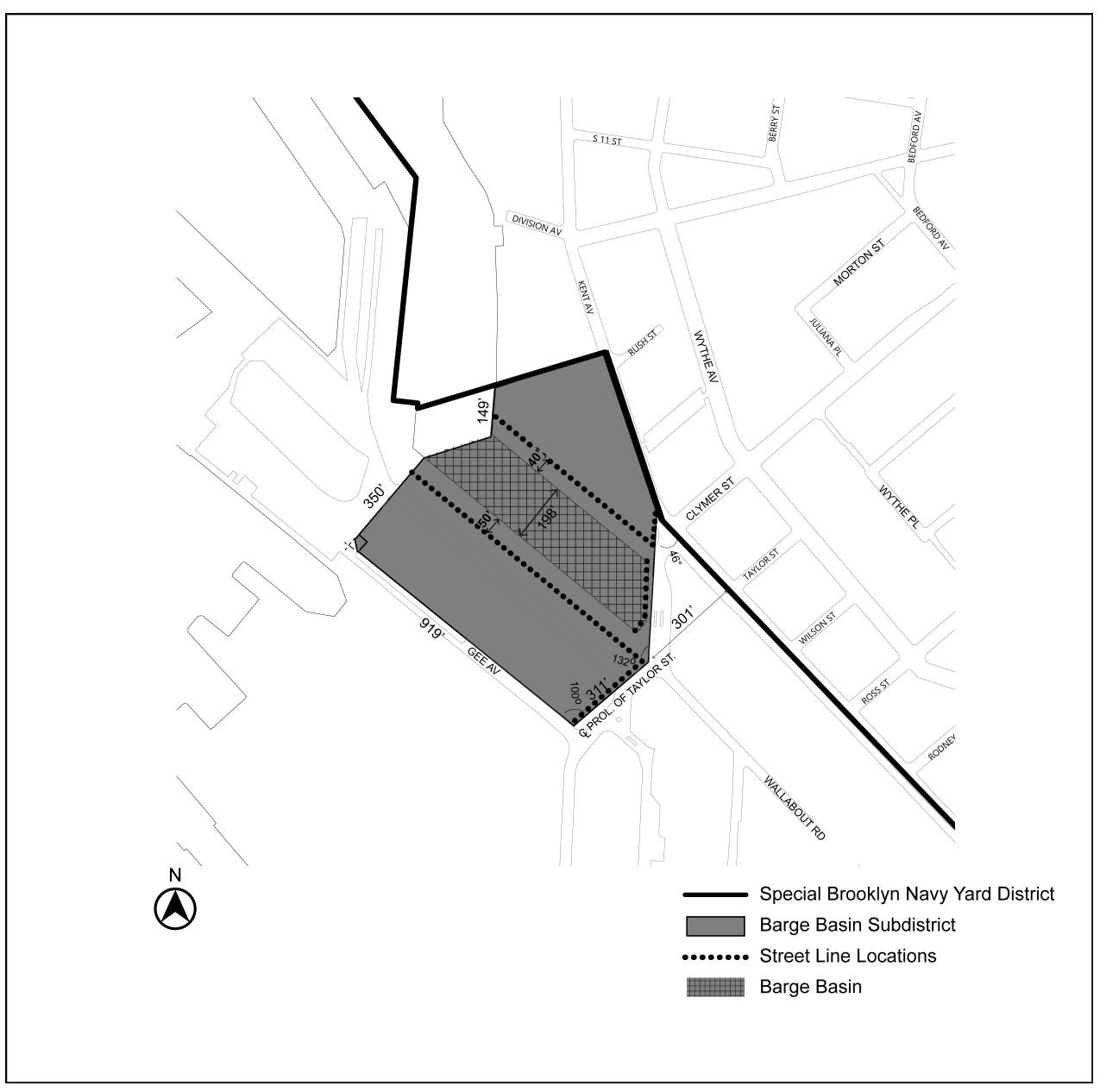
Barge Basin Subdistrict
In the Barge Basin Subdistrict, as shown on Map 5 in the Appendix to this Chapter, the height and setback regulations set forth in Section 43-40 (HEIGHT AND SETBACK REGULATIONS), inclusive, shall apply, as modified by the provisions of this Section.
For purposes of applying the height and setback provisions of this Section, the street walls of abutting buildings shall be considered a single building street wall.
(a) Sidewalk widening
A sidewalk widening shall be provided along Kent Avenue to the extent necessary so that a minimum width of 15 feet is achieved, including portions within and beyond the zoning lot. Such sidewalk widening shall be:
(1) improved as a sidewalk to Department of Transportation standards;
(2) at the same level as the adjoining public sidewalk; and
(3) accessible to the public at all times.
The interior boundary of the sidewalk widening shall be considered the street line for the purposes of this Section.
(b) Establishing street lines along Barge Basin
For the purposes of applying the height and setback regulations of this Section to portions of buildings fronting Barge Basin and prolongations thereof, the following shall be considered street lines along a wide street:
(1) Along the long dimension of the Barge Basin
Along the long dimension of the Barge Basin a line offset 40 feet northeast from the northeastern boundary of the Barge Basin in the Barge Basin East Subarea, and a line offset 50 feet southwest from the southwestern boundary of the Barge Basin in the Barge Basin West Subarea, shall be considered street lines.
The area between the Barge Basin and such street lines shall be improved as publicly accessible areas in accordance with the applicable provisions of Section 144-30 (SPECIAL PUBLIC ACCESS AREA REGULATIONS), inclusive.
(2) Along the short dimension of the Barge Basin
Along the short dimension of the Barge Basin, the southeasterly boundaries of the Barge Basin Subdistrict, including the boundary extending from the centerline prolongation of Taylor Street, and the boundary constructed from an offset of the southeastern terminus of the Barge Basin, shall be considered street lines.
Within the area between the Barge Basin and such street lines shall be an area adjacent to the short dimension of the Barge Basin that connects the Barge Basin East Subarea pedestrian esplanade and the Barge Basin West Subarea pedestrian esplanade that shall be:
(i) improved as a sidewalk to Department of Transportation standards;
(ii) at the same level as the adjoining public sidewalk; and
(iii) accessible to the public at all times the public access areas are required to be open to the public, pursuant to Section 144-33 (Hours of Operation).
The locations of these street lines, are shown on Map 5 in the Appendix to this Chapter.
(c) Street wall location, and articulation
At least 70 percent of the aggregate width of street walls facing Barge Basin shall be located within eight feet of the street line and shall extend to at least a minimum base height of 30 feet, or two stories, whichever is lower. The remaining aggregate width of street walls may be recessed beyond eight feet of the street line, provided that any recesses deeper than 10 feet are located within an outer court.
Any open area between a street wall and the street lines along Barge Basin that is within eight feet of such street line shall be improved as publicly accessible areas in accordance with the applicable provisions of Section 144-30, inclusive. Open areas between the street line and street walls that are beyond eight feet of such street line may be publicly accessible areas, as needed, to achieve the minimum percentage of public access area required by each Subarea pursuant to Section 144-31 (Required Public Access Area).
For those portions of buildings facing Barge Basin with a street wall width exceeding 200 feet, a minimum of 20 percent of the surface area of such street wall up to the height of the second story, or 30 feet, whichever is lower, and a maximum of 50 percent of such surface area, shall either recess or project from the remaining surface area of the street wall by a minimum of three feet. Building projections shall be a permitted obstruction within any open area between the street wall and street line, including publicly accessible areas, provided that the minimum percentage of public access area required by each Subarea pursuant to Section 144-31 remains open to the sky. Additional permitted obstructions are allowed in accordance with paragraph (a) of Section 144-32 (Design Requirements).
(d) Base heights, required setbacks, and dormers
The front setback provisions applicable to an M1-5 District set forth in Section 43-43 (Maximum Height of Front Wall and Required Front Setbacks) shall apply, except as modified by the provisions of this Section. The alternate front setback regulations of Section 43-44 (Alternate Front Setbacks) shall not apply.
(1) Initial setback distances
The initial setback distance regulations shall be modified as follows:
(i) along the Barge Basin, such initial setback distance shall have a depth of at least 30 feet from the street line;
(ii) along all other wide streets, such initial setback distance shall have a depth of at least 15 feet from the street line; and
(iii) such initial setback distance shall be provided at a height not lower than the minimum base height, where applicable, nor higher than a maximum base height of 85 feet, or six stories, whichever is lower.
(2) Dormers
Along the Barge Basin frontages, dormers shall be a permitted obstruction within an initial setback distance, provided that:
(i) the depth of such dormers does not exceed 10 feet for buildings fronting along the northeastern boundary of the Barge Basin or 20 feet for buildings fronting along the southwestern boundary;
(ii) the street wall width of such dormer does not exceed 30 percent of the street wall width of the building above the maximum base height; and
(iii) the street wall width of such dormer along a single tower does not exceed 100 feet.
(e) Towers
The allowances for towers to penetrate a sky exposure plane applicable to an M1-5 District, as set forth in Section 43-45 (Tower Regulations), shall apply, except as modified by the provisions of this Section.
The tower allowances shall be modified as follows:
(1) for the purposes of determining the lot area a tower may occupy, the Barge Basin East Subarea and the Barge Basin West Subarea shall each be considered an individual zoning lot;
(2) the underlying setback provisions, including the aggregate area permitted within 40 feet of a wide street, shall not apply. In lieu thereof, the setbacks and dormer allowances set forth in paragraph (d) of this Section shall apply; and
(3) the street wall width of a tower fronting Barge Basin shall not exceed 200 feet within 200 feet of the street line fronting Barge Basin.
Within the Special Brooklyn Navy Yard District the City Planning Commission may, by special permit, allow modifications to the bulk regulations of this Chapter and the underlying bulk regulations, except floor area regulations, provided the Commission finds that:
(a) such modifications further the needs and objectives of the Special Brooklyn Navy Yard District;
(b) such bulk modifications will result in a better site plan and will benefit the occupants and users of the Special Brooklyn Navy Yard District and the residents of the surrounding neighborhood;
(c) such bulk modifications will permit adequate access to light and air to surrounding public access areas, streets and properties; and
(d) such distribution of bulk will not unduly increase the bulk of buildings in the Special Brooklyn Navy Yard District to the detriment of the occupants or users of buildings in the Special Brooklyn Navy Yard District or on nearby blocks.
The Commission may impose appropriate conditions and safeguards to assure that such modifications will not adversely affect the surrounding area.
Within the Special Brooklyn Navy Yard District, public access areas shall be provided in connection with developments or enlargements located within the Subareas identified in this Section, inclusive, as applicable. For the purposes of determining the amount of public access area required in the Navy Street Central Subarea, the Barge Basin East Subarea, and the Barge Basin West Subarea, each such Subarea shall be deemed a single zoning lot.
Required Public Access Areas
Mandatory public access areas in connection with any development or enlargement shall be provided in accordance with the provisions of paragraphs (a) through (c) of this Section. The phasing of public access areas shall be permitted in accordance with paragraph (d). Developments or enlargements that are exempt from public access area requirements are set forth in paragraph (e).
(a) Navy Street Central Subarea
A public access area in an amount equal to at least 15 percent of the lot area of the Navy Street Central Subarea shall be provided within the boundaries of such Subarea. The required public access area shall have a minimum dimension, in all directions, of 50 feet for at least 80 percent of the public access area and shall have no dimension of less than 30 feet for the remainder of the required public access area.
(b) Flushing East Subarea
A public access area with a minimum depth of 50 feet, as measured perpendicular to the street line of Flushing Avenue, shall be provided within the boundaries of such Subarea along the entire length of the street wall line adjacent to the development or enlargement, and shall extend to the nearest view corridors depicted on Map 4 (Flushing Avenue Subareas and View Corridors) of this Chapter, and for developments or enlargements located east of the Waverly Avenue view corridor, to the boundary of the prolongation of Washington Avenue.
(c) Barge Basin East and West Subareas
A public access area in an amount of at least 30 percent of the lot area of Barge Basin East Subarea, and a public access area in an amount of at least 20 percent of the lot area of Barge Basin West Subarea shall be provided within such respective Subareas.
Such public access areas shall consist of:
(1) in the Barge Basin East Subarea, a pedestrian esplanade with a seaward edge contiguous with the eastern edge of the Barge Basin and a minimum width of 40 feet, as measured perpendicular to such edge, and in the Barge Basin West Subarea, a pedestrian esplanade with a seaward edge contiguous with the western edge of the Barge Basin and a minimum width of 50 feet, as measured perpendicular to such edge;
(2) in the Barge Basin East Subarea, a pedestrian connection with a minimum width of 30 feet located along the shared boundary between the Barge Basin East Subarea and the contiguous property to the northeast connecting the Kent Avenue and the eastern portion of the pedestrian esplanade required by this Section;
(3) in the Barge Basin East Subarea, a pedestrian connection with a minimum width of 60 feet, located within 150 feet of the southern boundary of the Barge Basin East Subarea and connecting Kent Avenue and the pedestrian esplanade required by this Section;
(4) in the Barge Basin West Subarea, an esplanade entry area at the southern end of the Barge Basin West Subarea, having a minimum width of 60 feet and a minimum length of 30 feet measured parallel to the western edge of the Barge Basin; and
(5) any supplemental publicly accessible space contiguous to one or more of the elements set forth above as may be required to achieve the required percentage of publicly accessible area.
(d) Public Access Area Phasing
Where the Navy Street, Barge Basin East and Barge Basin West Subareas are developed with more than one building or enlarged in phases, or there is an increase in building lot coverage, the mandatory public access area may be constructed in phases, provided that, at the completion of each phase by certification of the Chairperson of the City Planning Commission, the following criteria are met:
(1) the square footage of public access area being provided in any phase shall be in proportion to the total public access requirement based on the area of the Subarea being developed or enlarged as compared to the lot coverage of the Subarea. Any public access area provided in an earlier phase in excess of the amount required for such phase may be applied to a later phase;
(2) the public access area being proposed in any phase shall not prevent the total amount of public access area required for a Subarea from being achieved;
(3) any phased portion of the required public access area shall comply with the minimum widths and other dimensions required for the public access areas;
(4) any phased portion of the required public access area shall connect directly to either a street or an improved public access area;
(5) in the Barge Basin West Subarea:
(i) public access to be provided shall include the portion of the required public access area located between the development or enlargement and the Barge Basin; and
(ii) where any development or enlargement included in a phase is located within 100 feet of the southern boundary of the Subarea, the public access area shall also include the required public access area between the southern boundary and the development or enlargement; and
(6) a proportionate amount of planting shall be included within each phase.
(e) Exceptions to Public Access Area Requirements for Minor Developments
The public access area requirements of paragraphs (a) through (d) of this Section shall not apply to any development or enlargement where:
(1) the additional floor area created through such development or enlargement in the respective Subarea, as compared to the floor area existing on December 15, 2021, does not exceed:
(i) 10,000 square feet in either the Barge Basin East or the Navy Street Central Subareas; or
(ii) 20,000 square feet in either the Barge Basin West or Flushing East Subareas;
(2) such floor area is allocated exclusively to uses in Use Group 11, 16, 17, or 18; and
(3) such floor area is not located within the boundaries of designated public access areas required pursuant to this Section or, if located in the Navy Street Central Subarea, is not within 50 feet of a street.
Design Requirements
The required public access areas in each Subarea shall comply with the following provisions:
(a) The required public access area shall be open to the sky, provided that building awnings, entrance canopies, solar shading devices, and similar structures attached to an adjoining building and extending over the public access area shall be permitted;
(b) The required public access area shall include planted areas in an amount not less than 20 percent of the area of the required open space;
(c) At least one linear foot of seating shall be provided for each 200 square feet of required public access areas, except that for the pedestrian connection required pursuant to paragraph (c)(2) of Section 144-31, at least 12 linear feet of seating for every 100 feet of pedestrian connection shall be provided; and
(d) Public access area signage complying with the requirements of Section 37-751 (Public space signage systems) shall be located at all entry points to the public access areas.
(e) In the Barge Basin Subdistrict:
(1) the pedestrian esplanade around the Barge Basin and the pedestrian connections from Kent Avenue to the eastern pedestrian esplanade shall include a primary circulation path along the length of such elements with a minimum clear width of 10 feet; and
(2) at least three different types of seating shall be provided, which may include moveable seating, fixed individual seats, fixed benches with and without backs, and design-feature seating such as seat walls, planter ledges, or seating steps.
Additional amenities including pathways, seating steps, entrances to adjoining buildings, artwork, maritime or industrial elements, tables, seating above the required minimum, lighting fixtures, litter receptacles, kiosks, children play areas, railings, drinking fountains, water features, planting and trees may be included in the public access areas and shall be permitted obstructions.
Hours of Operation
All public access areas shall be open to the public from 6:00 a.m. to 10:00 p.m. from April 15th to October 31st and from 7:00 a.m. to 8:00 p.m. from November 1st to April 14th, except when required to be closed for repairs.
Maintenance
The owner of each applicable portion of a Subarea, or a ground tenant if the applicable portion is subject to a ground lease, shall be responsible for the maintenance and operation of the required public access area. Maintenance shall include, but not be limited to, necessary repairs, litter control and the care and replacement of vegetation. The owner or ground tenant of a public access area may temporarily close the smallest portion reasonably necessary for the shortest period of time reasonably necessary to make repairs or to mitigate hazardous or emergency conditions, or in connection with construction on adjacent areas.
No excavation or building permit shall be issued for any development or enlargement requiring the provision of a public access area in the Navy Street Central Subarea, the Barge Basin East Subarea, or the Barge Basin West Subarea until the Chairperson of the City Planning Commission certifies to the Department of Buildings or Department of Small Business Services, as applicable, that a complete application has been submitted showing compliance with the applicable provisions of Section 144-30, inclusive.
Within 45 days of submission of such complete application, the Chairperson shall either certify that the proposed public access area complies with the requirements of this Section or disapprove such complete application in writing, citing the nature of any failure to comply. Failure to certify or disapprove such complete application within the 45-day period will release the Department of Buildings or the Department of Small Business Services from any obligation to withhold the excavation or building permit and authorize such agency to determine compliance with the provisions of this Section.
No temporary certificate of occupancy shall be issued by the Department of Buildings or Department of Small Business Services for floor area in a development or enlargement resulting in a public access area requirement under Section 144-31 (Required Public Access Areas) without the substantial completion of the public access area required for such development or enlargement, and no final certificate of occupancy shall be issued prior to the final completion of the required public access area.
Notwithstanding the provisions above, the Department of Buildings or the Department of Small Business Services, as applicable, may issue a temporary certificate of occupancy allowing for floor area allocated to uses listed under Use Group IV(B), IX or X without the substantial completion of the required public access area, in which case the public access area shall be completed within one year of the issuance of the first such certificate of occupancy. Following such one-year period, no additional floor area within the development or enlargement shall receive a certificate of occupancy until the substantial completion of the required public access area.
Within the Special Brooklyn Navy Yard District, mandatory district plan elements shall be provided in connection with developments or enlargements in the Navy Street Central Subarea, the Flushing East Subarea, and the Barge Basin Subdistrict.
The provisions of this Section shall apply to developments and ground floor level enlargements.
For the purposes of applying to this Chapter the special ground floor level streetscape provisions set forth in Section 37-30 (SPECIAL GROUND FLOOR LEVEL STREETSCAPE PROVISIONS FOR CERTAIN AREAS), inclusive, a ground floor level street frontage designated on Map 6 in the Appendix to this Chapter shall be considered a primary frontage, and any ground floor level frontage within 50 feet of a primary frontage shall be considered a secondary frontage. Primary frontages shall also include Priority Zones, which are also designated on Map 6.
Any primary or secondary frontages shall be considered streets for the purposes of applying the provisions of this Section. For the purposes of this Section, defined terms shall include those in Sections 12-10 and 37-311.
- Along primary frontages
- Minimum frontage width
For portions of buildings fronting a primary frontage, at least 50 percent of the street wall width of the ground floor level of such primary frontage shall be occupied by floor area.
In addition, for portions of buildings fronting a Priority Zone of a primary frontage, at least 50 percent of the street wall width of the ground floor level of such Priority Zone shall be occupied by floor area. Floor area provided within a Priority Zone may be counted towards the floor area requirement along the primary frontage. - Minimum depth
The floor area provided to meet the requirements of paragraph (a)(1) of this Section shall extend to the minimum depth set forth in Section 37-32 (Ground Floor Depth Requirements for Certain Uses) within the Priority Zone, and outside of a Priority Zone shall extend to a minimum depth of 15 feet. - Transparency requirement
The portion of the ground floor level street wall along a primary street frontage allocated to such minimum floor area requirements of paragraph (a)(1) of this Section shall be glazed in accordance with the provisions set forth in Section 37-34 (Minimum Transparency Requirements). However, where such minimum floor area is attributed to uses listed under Use Groups IV(B), IX or X, the minimum percentage to fulfill the minimum transparency requirement shall be reduced to 25 percent and the maximum width of a portion of the ground floor level street wall without transparency may exceed 10 feet provided that any portion of the ground floor level street wall without transparency shall be subject to the provisions for Type 1 blank walls.
- Minimum frontage width
- Blank wall provisions along primary and secondary frontages
Along both primary and secondary frontages, any street wall width of 50 feet or more with no transparent elements on the ground floor level shall provide visual mitigation elements in accordance with the provisions for Type 1 blank walls set forth in Section 37-361 (Blank wall thresholds).
Within the Special Brooklyn Navy Yard District, the accessory off-street parking and loading regulations of Article IV, Chapter 4 shall not apply, except as specifically set for the in this Section.
Permitted Accessory Parking
In all districts, accessory off-street parking spaces shall be permitted in group parking facilities without a limitation in the overall number of spaces.
Loading Berths
In all districts, loading berths are not required, but are permitted. Any loading berths provided shall be deemed required loading berths for purposes of determining the amount of floor area in any building.
Curb Cuts
Access to any accessory off-street loading berth and off-street parking areas for a development or enlargement within the Navy Street Central Subarea, the Flushing East Subarea, and the Barge Basin East Subarea shall be limited to one curb cut from the adjoining street.
An additional curb cut may be added in the Barge Basin East Subarea upon certification by the Chairperson of the City Planning Commission to the Commissioner of Buildings or the Department of Small Business Services, as applicable, that an additional curb cut has been approved by the Commissioner of the Department of Transportation.
In addition, where the Chairperson of the City Planning Commission certifies such additional curb cut, the Chairperson may certify a reduction in the ground floor level streetscape provisions of paragraph (a) of Section 144-41 (Ground Floor Streetscape Provisions), to the minimum extent necessary, where the applicant demonstrates that the reduction is necessary to accommodate the proposed loading configuration on the ground floor. For such portions of the ground floor level, the provisions of paragraph (b) of Section 144-41 shall continue to apply.
The Chairperson shall issue the certification within 45 days of receipt of a communication from the Department of Transportation approving an additional curb cut or receipt of application materials demonstrating the proposed loading configuration, as applicable. Failure to certify within the 45-day period will release the Department of Buildings or the Department of Small Business Services from any obligation to withhold the excavation or building permit and authorize such agency to determine compliance with the provisions of this Section.
Bicycle Parking
The requirements of Section 44-60 (BICYCLE PARKING) shall apply, provided that up to half of the required spaces may be provided as unenclosed bicycle parking spaces, and may be located anywhere on the zoning lot.
In lieu of the requirements of Section 44-21 (General Provisions), a Transportation Management Plan may be prepared for the Special Brooklyn Navy Yard District that documents:
(a) existing parking within the Special District;
(b) parking and bicycle parking utilization rates;
(c) transportation mode choice;
(d) plans, if any, for additional parking within the Special District;
(e) public transportation options in and around the Special District;
(f) indoor and outdoor bicycle parking facilities, including any covered outdoor bicycle spaces; and
(g) measures being employed and planned to incentivize alternate means of transportation.
Any Transportation Management Plan shall be filed with the Department of City Planning and made available to the public via a website. The Transportation Management Plan shall be updated not less than every three years with surveys or other data collection undertaken not less than annually to document changes in parking facilities and utilization; the average number of employees and visitors arriving at the Special Brooklyn Navy Yard District and their modes of arrival; bike parking availability and utilization of both open and enclosed facilities; transit options, and new technologies and strategies for managing the number of private vehicles accessing the Special District. Such updates shall be submitted to the Department of City Planning and made available to the public via a website and the submission to the Department of City Planning shall be accompanied by an affidavit from the owner or ground tenant stating that the Transportation Management Plan remains in effect or, if it is no longer in effect, the date on which the Transportation Management Plan terminated.
Any development or enlargement occurring after the date a Transportation Management Plan has terminated will be subject to the requirements of Section 44-21.
Reporting Requirements
No later than April 1 of every other calendar year, beginning April 1, 2023, the Brooklyn Navy Yard Development Corporation shall submit to the Chairperson of the City Planning Commission and to the Speaker of the City Council a report on the development and enlargement of buildings, and the types of uses contained within the Special Brooklyn Navy Yard District. Such report shall include, but shall not be limited to:
- the name of each business establishment existing in the Special Brooklyn Navy Yard District. For each business establishment, the address or building number and floor, type of business, size, and lease duration;
- new leases executed during the reporting period, categorized by tenant name, type of business, size, and lease duration;
- the amount of floor area in developments and enlargements created after December 15, 2021, in each of the following Use Groups, subgroups and specific use as listed in this Resolution:
- uses listed under Use Group III;
- retail uses listed under Use Group VI;
- uses listed under Use Group VII;
- art, music, dancing or theatrical studios listed under Use Group VIII;
- production or entertainment studios listed under Use Group VIII;
- uses listed under Use Group IX(A);
- uses listed under Use Group X; and
- any other uses; and
- the number of buildings developed or enlarged during the reporting period and the amount of floor area and uses contained within such development or enlargement.
APPENDIX A
Special Brooklyn Navy Yard District Plan
Map 1 — Special Brooklyn Navy Yard District and Subdistricts
Map 2 — Barge Basin Subareas
Map 3 — Navy Street Central Subarea
Map 4 — Flushing Avenue Subareas and View Corridors
Map 5 — Street Line Locations in the Barge Basin Subdistrict
Map 6 — Primary Street Frontages