Chapter 7 - Special Flushing Waterfront District (FW)
GENERAL PURPOSES
The “Special Flushing Waterfront District” established in this Resolution is designed to promote and protect public health, safety and general welfare. These general goals include, among others, the following specific purposes:
(a) to enhance neighborhood economic diversity by broadening the range of housing choices for residents of varied incomes;
(b) to create a lively and attractive built environment that will provide amenities and services for the use and enjoyment of area residents, workers and visitors;
(c) to encourage well-designed development that complements the pedestrian experience and enhances the built character of the neighborhood;
(d) to establish and maintain physical and visual public access to and along Flushing Creek;
(f) to make use of the waterfront by providing public access via private street network, direct connections to the water and to promote coordinated redevelopment of the area in a manner consistent with waterfront access and internal circulation within the Special District; and
(g) to promote the most desirable use of land and building development in accordance with the District Plan for Downtown Flushing and thus conserve the value of land and buildings and thereby improve the City’s tax revenues.
General Provisions
The provisions of this Chapter shall apply within the Special Flushing Waterfront District. The regulations of all other Chapters of this Resolution are applicable, except as superseded, supplemented or modified by the provisions of this Chapter. In the event of a conflict between the provisions of this Chapter and other regulations of this Resolution, the provisions of this Chapter shall control unless expressly stated otherwise.
District Plan and Maps
In order to carry out the purposes and provisions of this Chapter, district maps are located in the Appendix to this Chapter and are hereby incorporated and made an integral part of this Resolution. They are incorporated for the purpose of specifying locations where special regulations and requirements, as set forth in the text of this Chapter, apply.
Map 1: Special Flushing Waterfront District and Subdistricts
Map 2: Publicly Accessible Private Street Network
Map 3: Requirements Along Street Frontages
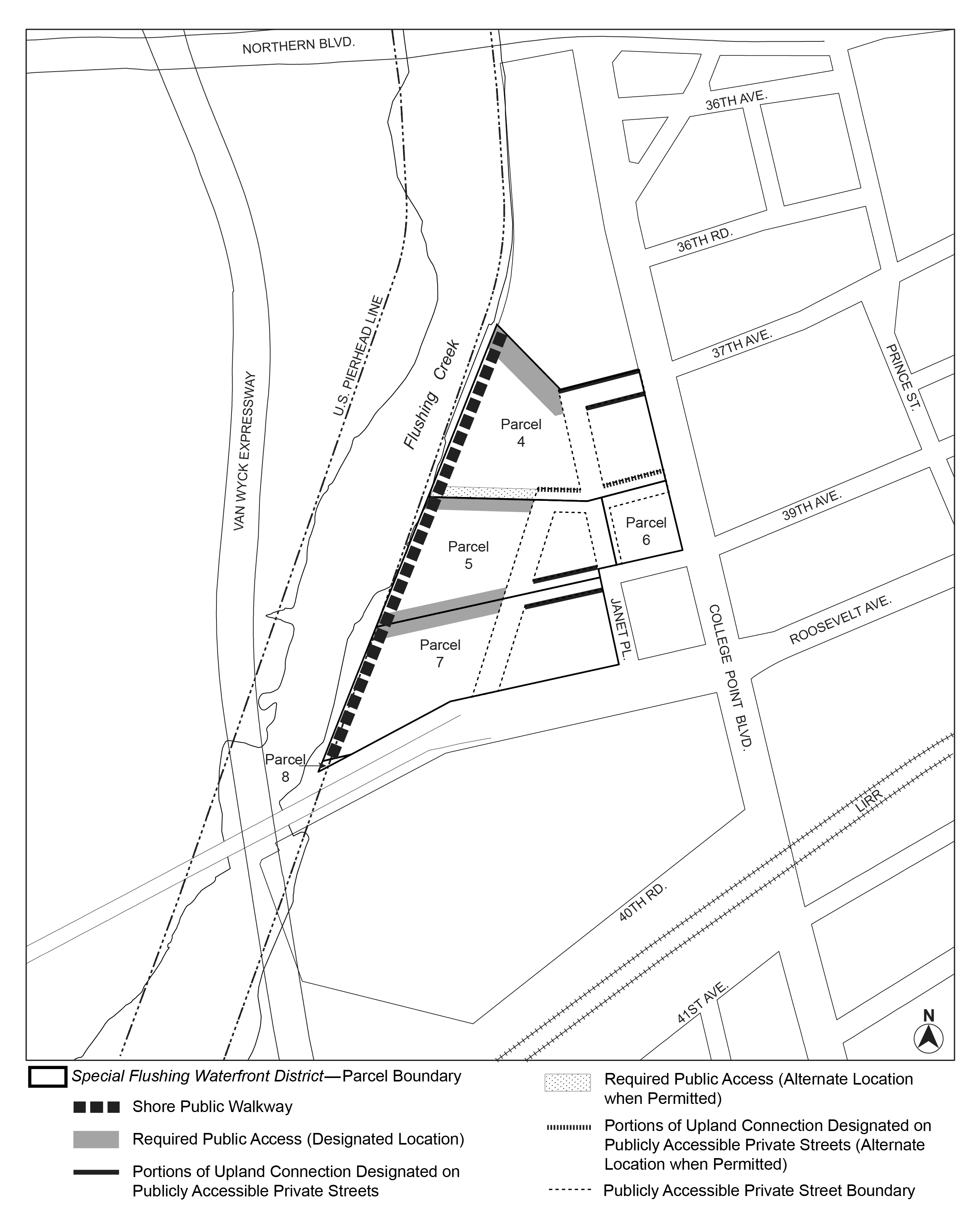
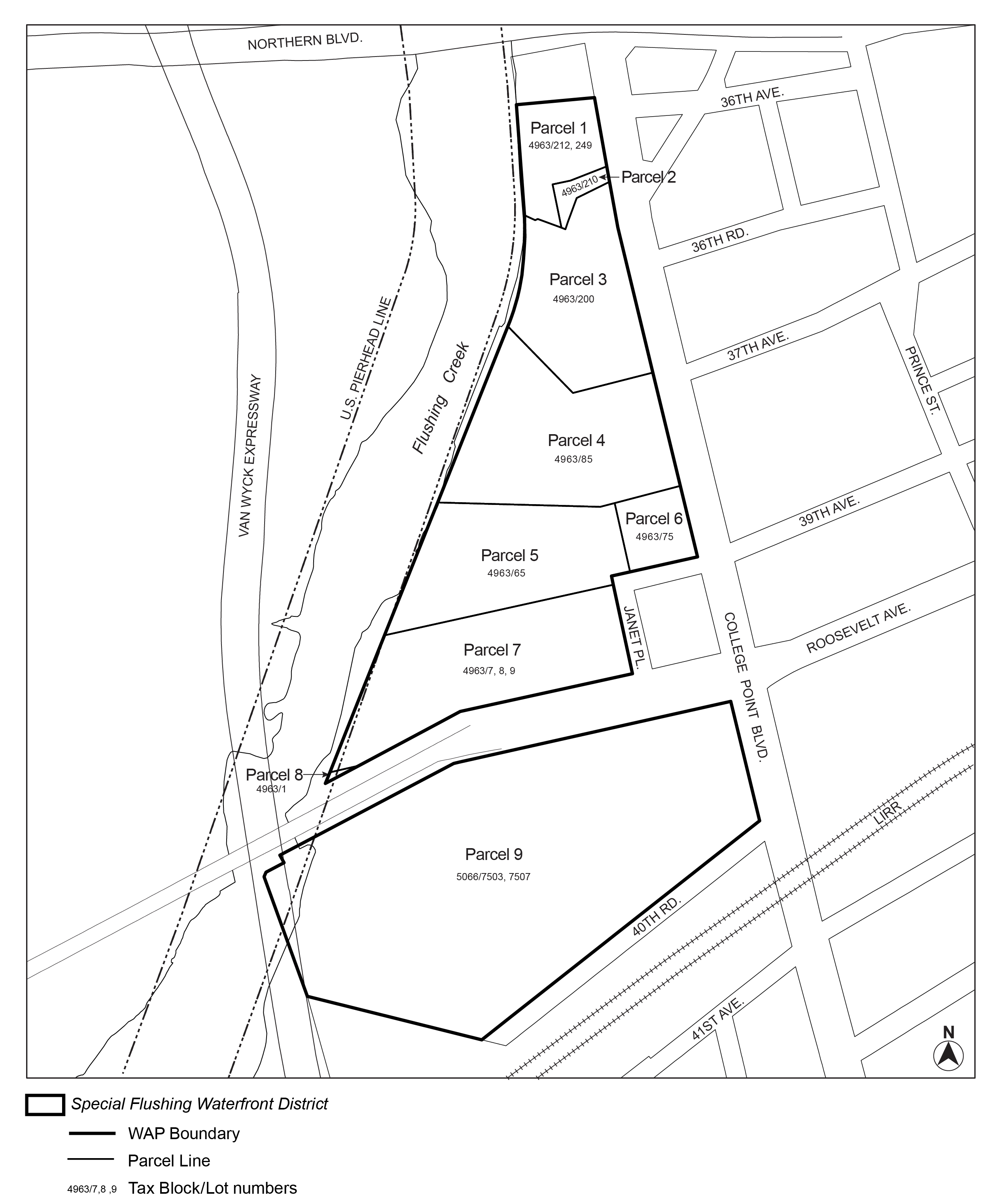
Map 4: Waterfront Access Plan: Parcel Designation
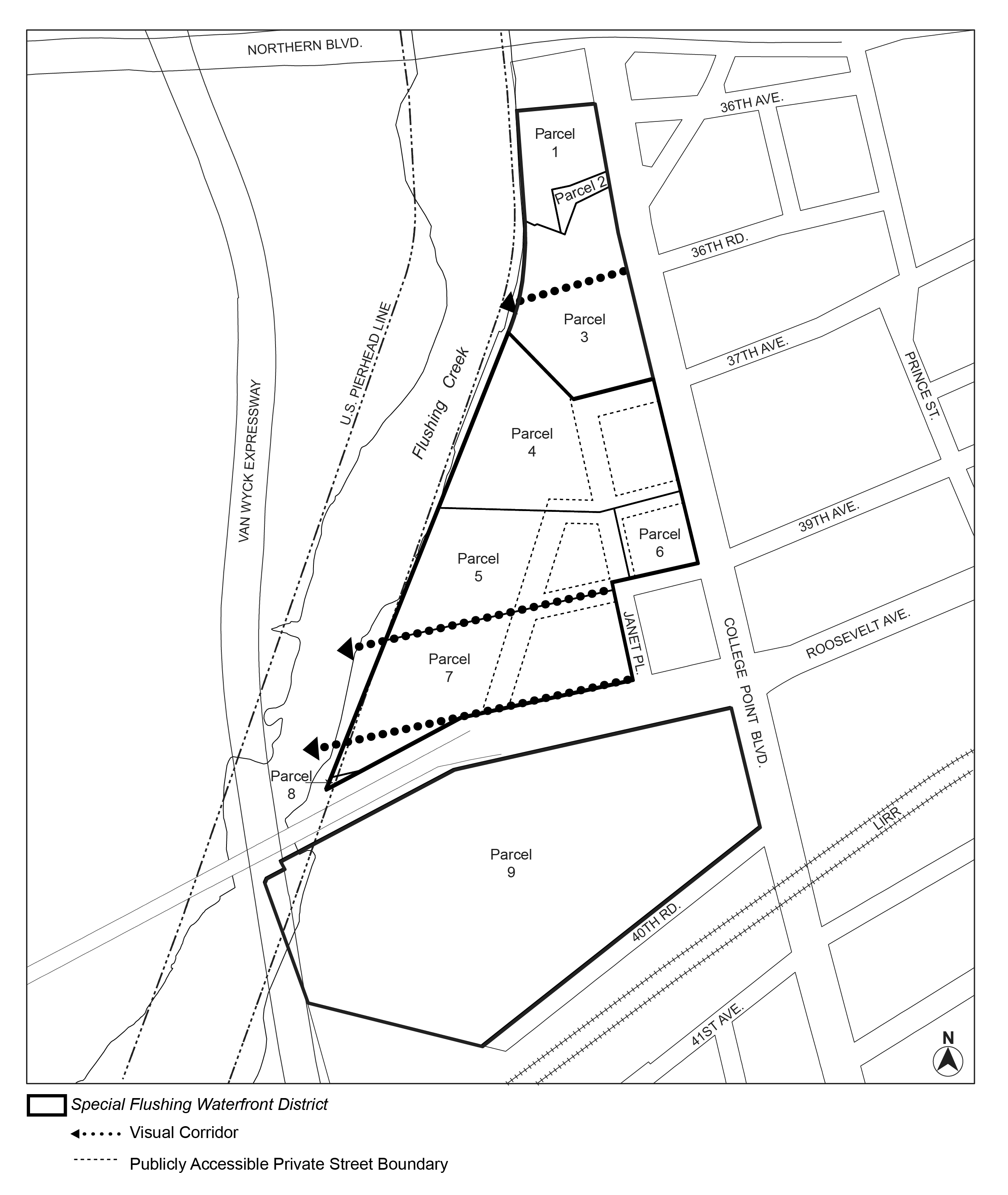
Map 5: Waterfront Access Plan: Visual Corridors
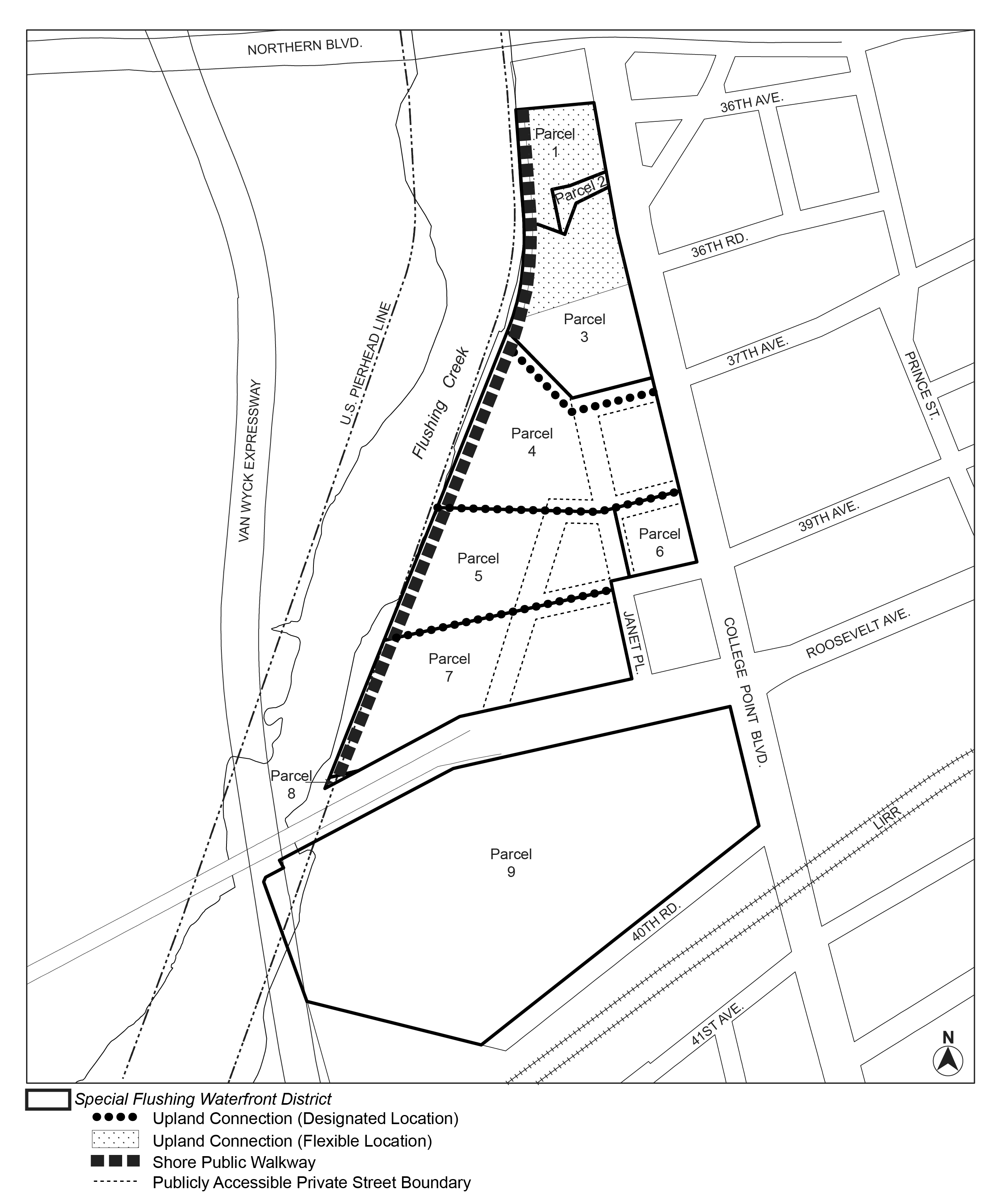
Map 6: Waterfront Access Plan: Public Access Areas
Map 7: Waterfront Access Plan: Phase I Waterfront Public Access Improvements
Map 8: Waterfront Access Plan: Phase II Waterfront Public Access Improvements
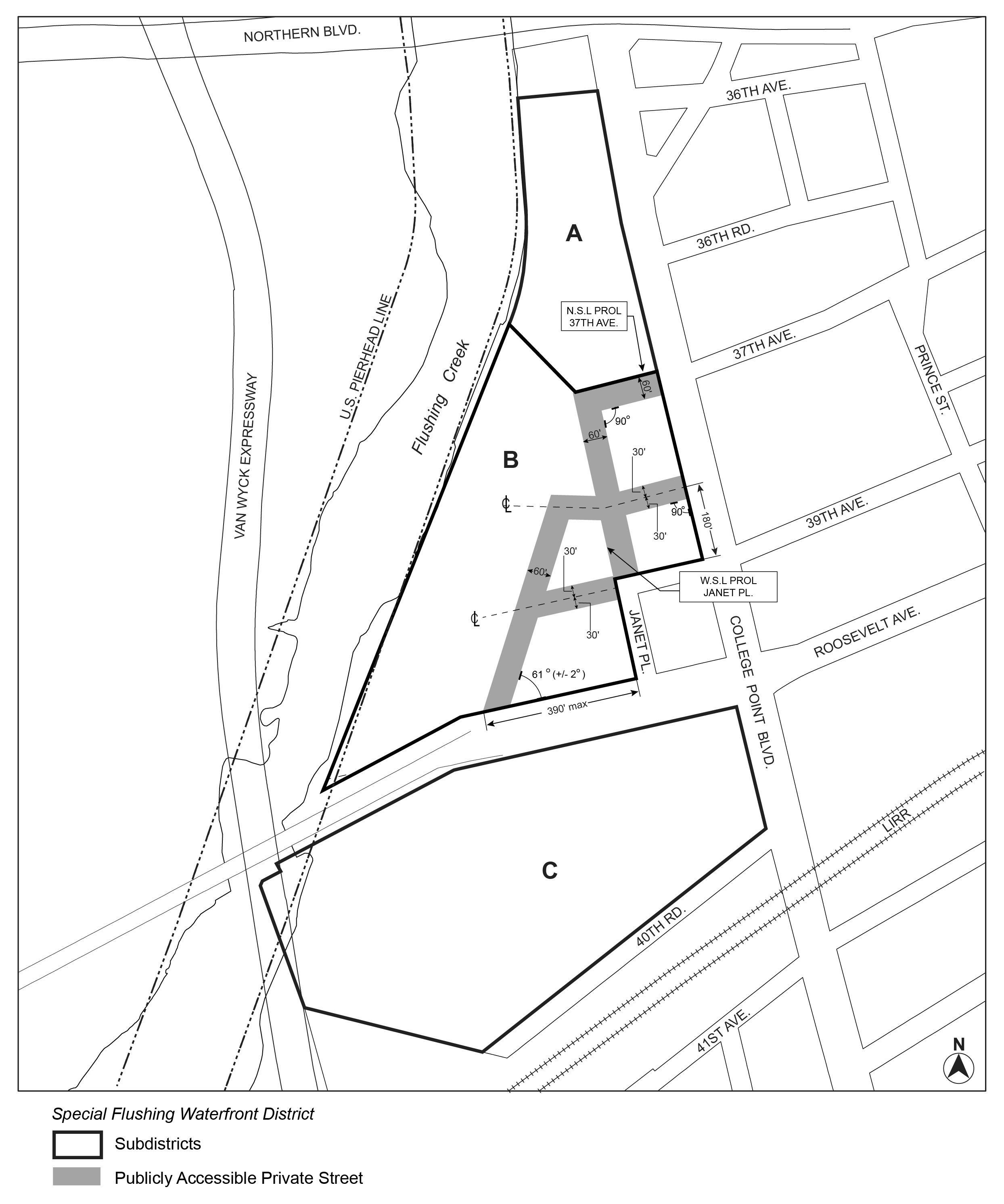
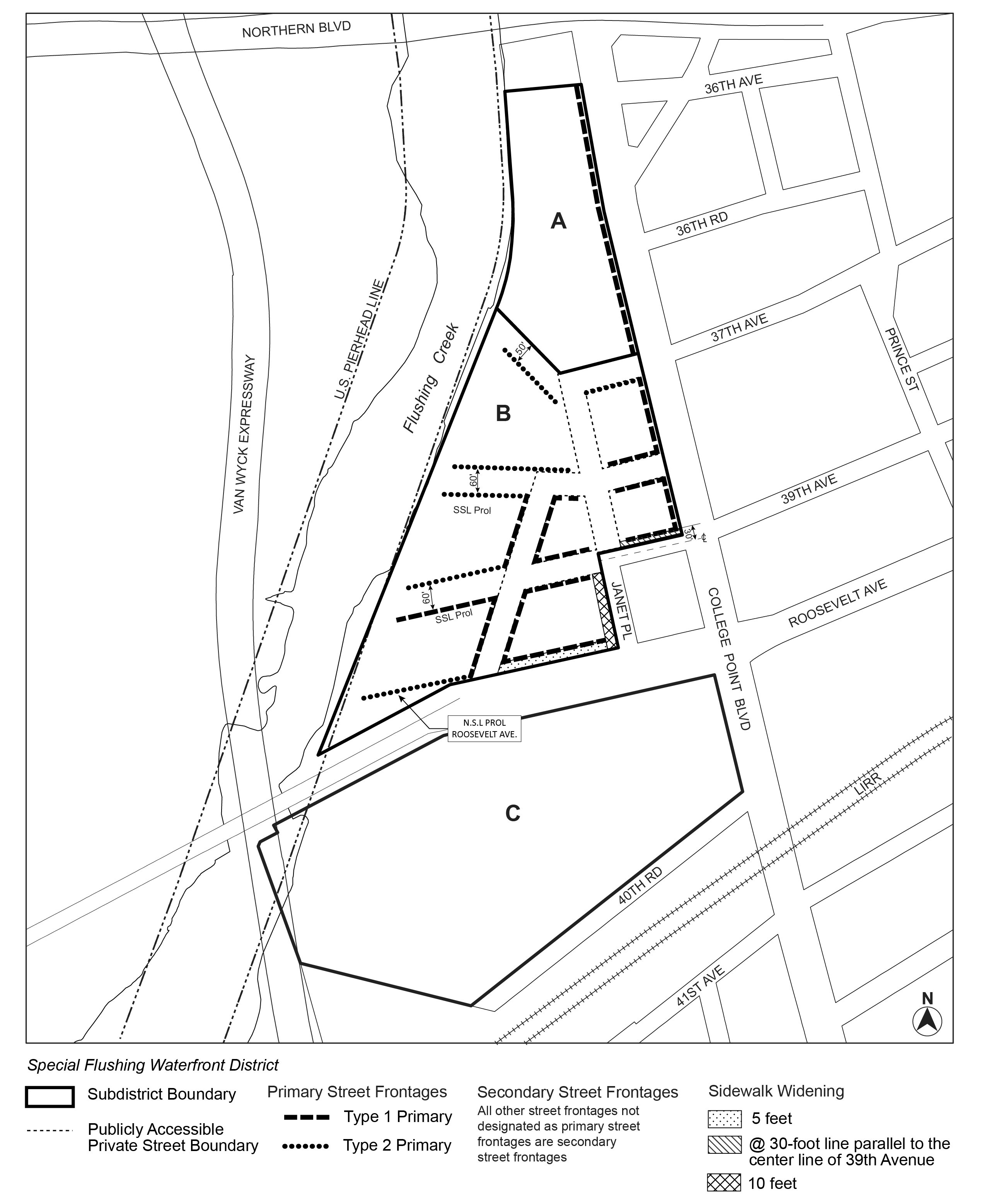
Subdistricts
In order to carry out the provisions of this Chapter, three subdistricts, Subdistrict A, Subdistrict B and Subdistrict C, are established.
The location and boundaries of these subdistricts are shown on Map 1 (Special Flushing Waterfront District and Subdistricts) in the Appendix to this Chapter.
Definitions
For purposes of this Chapter, matter in italics is defined in Section 12-10 (DEFINITIONS), Section 32-301 (Definitions) and within this Section, except where explicitly stated otherwise in individual provisions in this Chapter.
Conceptual plan
A “conceptual plan” is a plan that sets forth the proposed final design, in compliance with the requirements of Section 127-421 (Requirements for publicly accessible private streets), for the remaining portions of the publicly accessible private street or upland connection certified pursuant to paragraph (b)(1)(i) of Section 127-422 (Certification for publicly accessible private streets), or paragraph (a)(1)(i) of Section 127-542 (Supplemental provisions), respectively. The plan shall include the proposed location, dimensions and grading for such remaining portions on adjoining zoning lots and shall be considered by the Chairperson of the City Planning Commission in reviewing the proposed final site plan for such remaining portions, if and when they become the subject of a certification pursuant to paragraph (b)(2) of Section 127-422 or paragraph (a)(2) of Section 127-542.
Final site plan
A “final site plan” is a plan that specifies the final design for the location, dimensions, and grading of all or portions of the publicly accessible private streets or upland connection that are the subject of a certification pursuant to paragraphs (a) or (b) of Section 127-422 or paragraphs (a)(1) or (a)(2) of Section 127-542. Where applicable, the design of such plan shall be consistent with any conceptual plan for the same portion of the publicly accessible private street or upland connection and, once certified and implemented in accordance with paragraph (b) of Section 127-422 or paragraph (a) of Section 127-542, such plan shall supersede any interim plan for the same portion of a publicly accessible private street or upland connection.
Interim site plan
An “interim site plan” is a plan that specifies, for an interim period, the design for the location, dimensions, and grading of portions of the publicly accessible private street or upland connection that are the subject of a certification pursuant to paragraph (b)(1) of Section 127-422 or paragraph (a)(1) of Section 127-542 and located on the applicant’s zoning lot. A design for an interim period is necessary where it is not feasible to implement the final design for such portions until build-out of the remaining portions of the publicly accessible private street or upland connection occurs. Such interim site plan, once certified, shall remain in effect until implementation of the final site plan in accordance with paragraph (b) of Section 127-422 or paragraph (a) of Section 127-542, at which time the certified final site plan shall supersede the interim site plan.
Publicly accessible private street
A “publicly accessible private street” is a way specified on Map 2 in the Appendix to this Chapter that functions as a street for the purposes of general public use, including vehicular and pedestrian traffic, and is open and unobstructed from its ground level to the sky, except by streetscape elements required or permitted by the provisions of this Chapter.
For the purposes of applying the Mandatory Inclusionary Housing Program provisions set forth in Section 27-10 (ADMINISTRATION OF AFFORDABLE HOUSING), Mandatory Inclusionary Housing areas within the Special Flushing Waterfront District are shown in APPENDIX F (Mandatory Inclusionary Housing Areas and former Inclusionary Housing Designated Areas) of this Resolution.
The provisions of Article VI, Chapter I (Special Regulations Applying Around Major Airports) shall apply, except as modified in accordance with the provisions of this Chapter.
The provisions of Article VI, Chapter 2 (Special Regulations Applying in the Waterfront Area) shall apply in all waterfront areas, except as modified in accordance with the provisions of this Chapter.
The provisions of Article VI, Chapter 4 (Special Regulations Applying in Flood Zones) shall apply. In the event of a conflict between the provisions of this Chapter and Article VI, Chapter 4, the provisions of Article VI, Chapter 4 shall control.
In M1 Districts paired with a Residence District, the special use, bulk and parking and loading provisions of Article XII, Chapter 3 (Special Mixed Use District) shall apply, except as modified by the provisions of this Chapter, and shall supplement or supersede the provisions of the designated Residence District or M1 District, as applicable.
SPECIAL USE REGULATIONS
Within the Special Flushing Waterfront District, the use regulations of the underlying zoning districts and of Article VI, Chapter 2 (Special Regulations Applying in the Waterfront Area), and Article XII, Chapter 3 (Special Mixed Use District), shall apply, except as modified by the provisions of this Section, inclusive.
The provisions of Section 32-422 (Location of floors occupied by commercial uses) shall be modified such that the limitations set forth in paragraph (a) of such Section need not apply, and the requirements in paragraph (b) of such Section shall apply only where commercial uses are located above any story containing dwelling units.
Sign Regulations
For M1 Districts paired with a Residence District, the provisions regulating signs in C4 Districts, as set forth in Section 32-60 (SIGN REGULATIONS), inclusive, shall apply for any signs.
SPECIAL BULK REGULATIONS
For the purpose of applying the bulk regulations of this Section, inclusive, Subdistricts A, B and C, as shown on Map 1 in the Appendix to this Chapter, shall be considered waterfront blocks.
Within Subdistricts A and B, the applicable bulk regulations of the underlying districts and of Article VI, Chapter 2 (Special Regulations Applying in the Waterfront Area), and Article XII, Chapter 3 (Special Mixed Use District), shall apply, except as modified by the provisions of this Section, inclusive.
Within Subdistrict C, the applicable bulk regulations of the underlying districts and of Article VI, Chapter 2 shall apply.
All upland connections, visual corridors, shore public walkways and publicly accessible private streets, shall be considered streets and their boundaries shall be considered street lines for the purposes of applying all bulk regulations, except that such streets shall not subdivide a zoning lot. Furthermore, such streets shall be considered part of the zoning lot for the purpose of applying the floor area regulations of this Section, inclusive.
The floor area provisions of Section 62-32 (Floor Area Regulations on Waterfront Blocks) and applicable regulations shall apply except as modified in this Section, inclusive.
- Floor space for accessory off-street parking
The floor area of a building shall not include floor space used for accessory off-street parking spaces provided in any story located not more than 33 feet above the height of the base plane. - Special floor area regulations for mixed use districts
For M1 Districts paired with a Residence District, located inside a Mandatory Inclusionary Housing area, the maximum floor area ratio shall be 4.8 for community facility uses, 3.0 for commercial uses and 3.0 for manufacturing uses.
Special Yard Regulations
On waterfront zoning lots, the waterfront yard provisions of Section 62-33 (Special Yard and Lot Coverage Regulations on Waterfront Blocks) shall apply, except as modified as follows:
- for all waterfront zoning lots, as defined in Section 62-11 (Definitions), whose developments are comprised predominantly, as defined in Section 62-11, of uses in listed under Use Groups IV(B), IX or X, a waterfront yard, as also defined in Section 62-11, shall be provided in accordance with the provisions of Section 62-332 (Rear yards and waterfront yards); and
- the grading requirements of paragraph (b) of Section 62-332 (Rear yards and waterfront yards) may be modified pursuant to a certification by the Chairperson of the City Planning Commission as set forth in Section 127-61 (Certification for Interim Grading Conditions).
On zoning lots that are not waterfront zoning lots, no yard regulations shall apply.
The height and setback provisions of Section 62-34 (Height and Setback Regulations on Waterfront Blocks) shall be modified by the provisions of this Section, inclusive.
The height of all buildings or other structures shall be measured from the base plane, except where modified by specific provisions of this Section, inclusive, or by the provisions of Article VI, Chapter 4.
Sidewalk widenings shall be provided along specified street frontages and at specified depths as set forth on Map 3 (Requirements Along Street Frontages) in the Appendix to this Chapter. Such sidewalk widening shall be improved to Department of Transportation standards for sidewalks, and be at the same level as the adjoining sidewalk.
Permitted obstructions
The permitted obstruction provisions of paragraph (c) of Section 62-34 (Height and Setback Regulations on Waterfront Blocks) shall be modified as follows:
- the applicable dormer provisions shall be modified pursuant to the provisions of paragraph (c)(1) of Section 127-233 (Base heights and setback regulations);
- the penthouse regulations of paragraph (c)(1) of Section 62-34 shall not apply; and
- the maximum height of any permitted obstructions shall be determined in accordance with the provisions of Article VI, Chapter 1 (Special Regulations Applying Around Major Airports), except where modified by certification of the Chairperson of the City Planning Commission pursuant to Section 127-236 (Certification to modify maximum height of building or other structure).
Street wall location regulations
Along street frontages where a sidewalk widening is required pursuant to Map 3 in the Appendix to this Chapter, the street wall location requirements of this Section shall apply from the interior boundary of such sidewalk widening.
- Along primary street frontages
The street wall location provisions of paragraph (b) of Section 35-631 shall apply along primary street frontages, as shown on Map 3, except that the street wall shall rise to at least the minimum base height as specified in Section 127-233 (Base heights and setback regulations), or the height of the building, whichever is lower. The requirements of this paragraph shall not apply to the portion of a building adjacent to the major portion of a publicly accessible area, as specified in Section 127-43 (Publicly Accessible Area). - Along secondary street frontages
Along street frontages that are not designated as primary street frontages, street walls may be located at any distance from the street line.
- Along primary street frontages
Along primary street frontages, as shown on Map 3 (Requirements Along Street Frontages) in the Appendix to this Chapter, the following shall apply:- The minimum base height shall be 25 feet, or two stories, whichever is lower, and the maximum base height shall be 105 feet along College Point Boulevard and 75 feet along all other primary street frontages.
- Along Type 1 primary street frontages, at a height not lower than the minimum base height nor higher than the maximum base height, a setback with a minimum depth of 10 feet, as measured from the street wall, shall be provided, except that:
- the depth of such required setback may be reduced in accordance with the provisions of paragraph (a) of Section 23-433 (Standard setback regulations). However, where a sidewalk widening is required pursuant to this Section, as indicated on Map 4 (Waterfront Access Plan: Parcel Designation), the minimum depth of the required setback above the maximum base height may be reduced to five feet, as measured from the street wall ; and
- the depth of such setbacks may include the depth of recesses or outer courts in the street wall of the building base, provided that the aggregate width of any such recessed portion of a street wall with a setback of less than seven feet, as applicable, does not exceed 40 percent of the aggregate width of street wall at any level.
- Along Type 2 primary street frontages, a building may rise without any setback above the maximum base height.
- Along secondary street frontages
Along secondary street frontages, as shown on Map 3, the following shall apply:- Along the shore public walkway, the maximum base height shall be 75 feet, and any portion of a building that exceeds the maximum base height shall be set back at least 10 feet from the street line. Wherever a supplemental public access area is provided as a widened shore public walkway, such widened area shall be included in such setback distance.
- Along other secondary street frontages, the minimum base height shall be 25 feet, or two stories, whichever is lower, and the maximum base height shall be 75 feet. However, along secondary street frontages facing an upland connection with a width of less than 30 feet pursuant to the applicable provisions of paragraph (a) of Section 127-532 (Upland connections), the minimum base height shall be 15 feet. At a height not lower than the minimum base height nor higher than the maximum base height, a setback with a minimum depth of 10 feet, as measured from the street wall, shall be provided, except that:
- the depth of such required setback may be reduced in accordance with the provisions of paragraph (a) of Section 23-433. However, where a sidewalk widening is required pursuant to this Section, as specified on Map 3, the portion of a building located above the maximum base height need not set back more than 10 feet from the street line, provided such building portion meets the requirements of paragraph (d) of Section 127-234 (Tower regulations), as applicable; and
- the depth of such required setback may include the depth of recesses or outer courts in the street wall of the building base, provided that the aggregate width of any such recessed portion of a street wall with a setback of less than 10 feet, or the reduced setback distance pursuant to the provisions of paragraph (b)(2)(i) of this Section, as applicable, does not exceed 40 percent of the aggregate width of street wall at any level; and
- Additional allowances along all street frontages
- Within a required setback area, dormers provided in accordance with the provisions of paragraph (b)(1) of Section 23-413, shall be considered permitted obstructions, provided that:
- the height of such dormers does not exceed 135 feet in Subdistrict A and 175 feet in Subdistrict B, as measured above the base plane; and
- no dormers shall be permitted along street walls fronting on the shore public walkway.
- Notwithstanding the applicable setback regulations in paragraphs (a) and (b) of this Section, portions of buildings or other structures located:
- within 150 feet of a publicly accessible area, and either
- adjacent to such publicly accessible area, or
- along a street across from such publicly accessible area located on the same zoning lot,
may rise without a setback, provided that such publicly accessible area is in compliance with the provisions of Section 127-43 (Publicly Accessible Area). In addition, all street walls facing such publicly accessible area shall be subject to the articulation requirements of Section 127-235 (Supplemental articulation regulations).
- Within a required setback area, dormers provided in accordance with the provisions of paragraph (b)(1) of Section 23-413, shall be considered permitted obstructions, provided that:
Tower regulations
For the purposes of applying the provisions of this Section, a “tower” shall be any portion of a building or other structure that is located above the maximum base height. Such portion of a building or other structure shall be subject to the following requirements:
- Maximum tower widths
Along the shore public walkway, the maximum width of a tower, or portion thereof, that is located within 110 feet of the pierhead line and facing the shore public walkway, shall not exceed 100 feet. Such width shall be determined by drawing perpendicular lines in plan view from the pierhead line to the outermost extents of the street wall of such tower, or portion thereof, within 110 feet of the pierhead line, exclusive of any permitted projections and dormers. However, in Subdistrict A, where the depth of a zoning lot, or portion thereof, is less than 220 feet, the maximum width of a tower within such shallow lot portion, shall not exceed 130 feet, provided that such depth was in existence both on December 10, 2020, and on the date of application for a building permit.
Along all other streets, the aggregate width of street wall in a tower shall not exceed 250 feet. - Tower top regulations
For all zoning lots in Subdistrict A, and for each portion of a zoning lot in Subdistrict B, bounded entirely by streets, as such term is defined in Section 127-20, the following requirements shall apply:- Where two or more towers are provided and any portion of such towers exceeds 175 feet, a height difference of at least 20 feet, or two stories, whichever is less, shall be provided between such towers.
- Where any portion of a tower exceeds 175 feet, the highest two stories shall not exceed 90 percent of the gross area of the story located directly below such stories.
- Maximum tower height
The maximum height of a building or other structure shall be determined in accordance with the provisions of Article VI, Chapter 1 (Special Regulations Applying Around Major Airports), except where modified by certification of the Chairperson of the City Planning Commission pursuant to Section 127-236 (Certification to modify maximum height of building or other structure). - Additional requirements within Subdistrict B
Along Janet Place, where a sidewalk widening is required pursuant to Map 3, the width of each individual tower portion located within 50 feet of the street line of Janet Place shall not exceed 70 feet, exclusive of any permitted projections and dormers. Such width shall be determined by drawing perpendicular lines in plan view from the street line to the outermost extents of the street wall of such tower, or portion thereof, within 50 feet of the street line, exclusive of any permitted projections and dormers. Such tower portion and any other such tower portion within the same or an abutting building shall be separated by at least 40 feet.
In addition to all other provisions of Section 127-23 (Special Height and Setback Regulations), inclusive, for street wall widths exceeding 150 feet, as measured parallel to the street line, articulation shall be provided in accordance with the provisions of this Section.
The depth of required recesses or projections of a building shall be measured from the street wall. For the purpose of applying the provisions of this Section, the base height of such building shall be either the maximum base height or the height of such building where a required setback pursuant to the provisions of Section 127-233 (Base heights and setback regulations) is provided, whichever is lower. However, if such building provides multiple setbacks, the highest of such multiple setbacks shall be considered the base height of such building.
The portion of a tower street wall subject to the tower top regulations of paragraph (b) of Section 127-234 (Tower regulations) shall not be included for the purposes of determining or satisfying the articulation requirements of this Section. In addition, setbacks provided in accordance with the provisions of Section 127-233 shall not constitute recesses.
(a) Along all streets other than shore public walkways
For street walls fronting streets other than the shore public walkway, a minimum of 15 percent of the entire surface area of each street wall shall either recess or project a minimum of two feet from the street wall with no individual recess or projection exceeding 50 percent of such surface area of the street wall.
Along each street wall frontage, at least one-third of such overall 15 percent requirement shall be provided in the form of articulation below the base height of such building, and at least one-third shall be provided above the base height, respectively. The remaining one-third of such 15 percent requirement may be located anywhere on the street wall. Where a street wall frontage does not exceed the maximum base height, the overall 15 percent requirement shall be provided in the building base.
Within the articulation provided in the building base, the aggregate width of articulation at each level where provided shall achieve a street wall width that is equivalent to at least 10 percent of the aggregate width of street wall at that level, and no individual recess or projection shall have a street wall width of less than 10 feet.
In no event shall the total amount of projections above the base height exceed the thresholds permitted pursuant paragraph (c)(1) of Section 127-233.
(b) Along the shore public walkway
For street walls fronting the shore public walkway, at least five percent of the entire surface area of the street wall below the base height shall either recess or project a minimum of two feet from the street wall with no individual recess or projection exceeding 50 percent of such surface area of the street wall.
Within the articulation provided in the building base, the aggregate width of articulation at each level where provided shall achieve a street wall width that is equivalent to at least 10 percent of the aggregate width of street wall at that level, and no individual recess or projection shall have a street wall width of less than 10 feet.
The special permit provisions of Section 73-66 (Height Regulations Around Airports) shall not apply. In lieu thereof, the height restrictions of Sections 61-21 (Restriction on Highest Projection of Building or Structure) or 61-22 (Permitted Projection within any Flight Obstruction Area), may be modified where the Chairperson of the City Planning Commission has certified to the Department of Buildings that the provisions of this Section have been met. An application for such certification shall include:
(a) a site plan and elevations, showing the proposed building or other structure in relation to the underlying maximum height limits;
(b) separate verification letters from the Federal Aviation Administration and the Port Authority of New York and New Jersey that such building or other structure, including the location of temporary structures such as construction cranes, will not constitute a danger to the safety of air passengers or disrupt established airways or runway operations, respectively; and
(c) materials sufficient to demonstrate that the modified height of a building or other structure does not exceed 200 feet above mean sea level within Subdistrict A, and 245 feet above mean sea level within Subdistrict B.
Within the Special Flushing Waterfront District, the applicable parking and loading regulations set forth in Article III, Chapter 6 and Article IV, Chapter 4 (Accessory Off-street Parking and Loading Regulations), Article VI, Chapter 4 (Special Regulations Applying in Flood Zones), and Article XII, Chapter 3 (Special Mixed Use District) shall apply, inclusive, except as modified in this Section. For the purpose of applying the provisions of this Section, all upland connections, visual corridors, shore public walkways and publicly accessible private streets, as specified in Section 127-42 (Publicly Accessible Private Streets), shall be considered streets and their boundaries shall be considered a street line
The underlying parking regulations shall be modified as follows:
- In M1 Districts paired with a Residence District in Subdistrict A, the following shall apply:
- Commercial and manufacturing uses shall provide either one parking space for every 1,000 square feet of floor area, or shall provide parking spaces at the rate required for M1-2 Districts pursuant to Section 44-21 (General Provisions), whichever requires a smaller number of spaces.
In addition, the provisions of Sections 44-232 (Waiver of Requirements for Spaces Below Minimum Number) and 44-231 (Exceptions to application of waiver provisions) shall not apply to manufacturing uses. In lieu thereof, accessory off-street parking spaces may be waived for manufacturing and commercial uses if the number of spaces for all applicable uses is at or below 40 spaces. - Residential and community facility uses shall be subject to the parking requirements of R7-1 Districts, as set forth in Article II, Chapter 5 (Accessory Off-Street Parking and Loading Regulations).
- Commercial and manufacturing uses shall provide either one parking space for every 1,000 square feet of floor area, or shall provide parking spaces at the rate required for M1-2 Districts pursuant to Section 44-21 (General Provisions), whichever requires a smaller number of spaces.
- In C4-2 Districts within Subdistricts B and C, the parking requirements applicable to C4-4 Districts, as set forth in Article III, Chapter 6 (Accessory Off-Street Parking and Loading Regulations), shall apply.
Loading Regulations
The provisions of the underlying loading regulations shall be modified so that in C4-2 Districts, the loading requirements applicable to C4-4 Districts, as set forth in Article III, Chapter 6 (Accessory Off-Street Parking and Loading Regulations), shall apply.
DISTRICT PLAN ELEMENTS
Within Subdistrict A and Subdistrict B, the district plan element provisions of this Section shall apply.
The underlying ground floor level streetscape provisions set forth in Section 32-30 (STREETSCAPE REGULATIONS), inclusive, shall apply except that ground floor level street frontages within the 50 feet of the intersection of two primary street frontages, as shown on Map 3 (Requirements Along Street Frontages) in the Appendix to this Chapter shall be considered Tier C street frontages.
For the purpose of applying such streetscape regulations, upland connections, visual corridors, shore public walkways and publicly accessible private streets shall be considered streets and shore public walkways shall be considered #wide streets.
The provisions of this Section, inclusive, shall apply to any development, as defined in Section 62-11 (Definitions), on a zoning lot that contains any portion of a required publicly accessible private street.
Publicly accessible private streets shall be:
(a) accessible to the public at all times, except when required to be closed for repairs, and for no more than one day each year in order to preserve the private ownership of such area. Where an upland connection is designated on a publicly accessible private street as specified on Map 6 (Waterfront Access Plan: Public Access Areas) in the Appendix to this Chapter, the provisions of this paragraph shall supersede the hours of access provisions applicable to an upland connection;
(b) constructed to the dimensions specified on Map 2 (Publicly Accessibly Private Street Network) in the Appendix to this Chapter and be constructed to Department of Transportation standards for public streets including, but not limited to, sidewalks, curb design, lighting, traffic signage, pavement materials, drainage and crosswalks. In addition, where an upland connection is designated on a publicly accessible private street as specified on Maps 7 and 8 (Phase I and Phase II Waterfront Public Access Improvements, respectively) in the Appendix to this Chapter, the upland connection design requirements of Section 62-60 (DESIGN REQUIREMENTS FOR WATERFRONT PUBLIC ACCESS AREAS), inclusive, shall apply; and
(c) constructed with sidewalks that have a minimum clear path of eight feet along their street lines, except where an upland connection is designated on a publicly accessible private street. Such sidewalks shall be provided with street trees in accordance with the provisions of Section 26-41 (Street Tree Planting), except that such street trees shall be planted within a street tree pit or a raised planting bed, with at least 180 cubic feet of soil for each tree, and with a minimum horizontal width of four feet and vertical depth of 3 feet 6 inches, and such planting pit or raised planting bed shall be located adjacent to, and extend along the curb.
Where a publicly accessible private street is designated entirely within a zoning lot, the provisions of paragraph (a) of this Section shall apply. Where a publicly accessible private street is designated on two or more zoning lots and the design and construction of adjoining portions of the publicly accessible private street may not be finalized, the provisions of paragraph (b) of this Section shall apply. The provisions of paragraph (b) provide for certification of such portions of a publicly accessible private street in accordance with an interim site plan that satisfies the requirements of the New York City Fire Code; a conceptual plan for portions of the publicly accessible private street on other zoning lots that will be certified and constructed at a later time; and a final site plan, which will either supersede an interim site plan or be guided by a conceptual plan. The provisions of paragraph (c) shall apply to development on a zoning lot that contains any portion of a required publicly accessible private street.
No building permit shall be issued for a development on a zoning lot, containing any portion of a publicly accessible private street, until the Chairperson of the City Planning Commission certifies, in conjunction with a certification pursuant to Section 127-54 (Special Review Provisions) to the Department of Buildings that:
(a) where the publicly accessible private street is designated on one zoning lot, or where the publicly accessible private street is designated on two or more zoning lots and such publicly accessible private street will be constructed in its entirety concurrently with the applicant’s development, a final site plan has been submitted;
(b) where the publicly accessible private street is designated on two or more zoning lots and the portion of such publicly accessible private street located outside of the applicant’s property will not be or has not been constructed concurrently with the applicant’s development:
(1) if no prior certification pursuant to this Section was issued for a portion of the publicly accessible private street on another zoning lot, the Chairperson shall certify that:
(i) a conceptual plan has been submitted for the publicly accessible private street. In addition, certified mailing of notification that the applicant is seeking to commence construction of such publicly accessible private street shall be given to all other owners whose property contains any remaining portion of such publicly accessible private street, along with a copy of such conceptual plan;
(ii) a final site plan for the applicant’s zoning lot has been submitted showing compliance with the design standards of Section 127-421 (Requirements for publicly accessible private streets). In addition, where compliance with the fire apparatus access road requirements, set forth in the New York City Fire Code, require modifications to the design standards of Section 127-421, an interim site plan has been submitted that deviates from such design standards to the minimum extent necessary; and
(iii) the grading proposed in the final site plan, conceptual plan and interim site plan have been certified pursuant to Section 127-61.
Property owners of zoning lots containing any remaining portion of the publicly accessible private street shall have up to 30 days from the date of the applicant’s certified mailing of the notification required in paragraph (b)(1)(i) of this Section to respond to the applicant and to confirm for the Chairperson that the construction of the entire publicly accessible private street is not feasible concurrently with the applicant’s development. In the event that such notified property owners do not respond to the applicant and the Chairperson within the 30-day period, the applicant may proceed with completing this certification. Where a notified property owner responds that it is feasible to complete the portion of the publicly accessible private street on such owner’s zoning lot concurrently with the applicant’s portion, such property owner shall commence certification pursuant to the applicable provisions of this Section within 45 days from the date of submitting such response. In the event such notified property owners do not commence such certification within the 45-day period, the applicant may proceed with completing this certification.
In addition, where construction of publicly accessible private streets will not occur concurrently on the adjoining zoning lot, property owners of zoning lots containing any remaining portion of the publicly accessible private street shall have up to 45 days from the date of submitting their response to comment on any anticipated practical difficulties associated with the proposed location, dimensions and grading specified in the conceptual plan that would preclude the reasonable development of such owner’s property. Any submission of comments to the applicant and Chairperson shall include documentation from a licensed architect, landscape architect, or engineer, as applicable, that demonstrates the reason for such anticipated practical difficulties.
Copies of the approved conceptual plan, as well as the certified interim site plan and final site plan shall be forwarded to all property owners of a zoning lot containing any remaining portion of the publicly accessible private street.
Any portion of the publicly accessible private street constructed in compliance with a certified interim site plan shall be converted to the final design in compliance with the certified final site plan for such portion upon receiving notice from an adjoining property owner as set forth in paragraph (b)(2) of this Section that the remaining portion of the publicly accessible private street has been substantially completed and opened to the public.
(2) If a prior certification pursuant to paragraph (b)(1) of this Section was issued for a portion of a publicly accessible private street on another zoning lot, the Chairperson shall certify that:
(i) a final site plan for the applicant’s zoning lot has been submitted that is consistent with the conceptual plan from the prior certification; and
(ii) the proposed amenities and design elements within the final site plan in the applicant’s portion of a publicly accessible private street shall match or complement those that were previously constructed.
Upon substantial completion by applicant of its portion of the publicly accessible private street that has been constructed pursuant to a certified interim site plan and the opening of such portion to the public, notice shall be provided to any property owner of a zoning lot containing a portion of such publicly accessible private street. Such notice shall be provided to enable such other owner sufficient time, as shall be specified in the restrictive declaration required pursuant to paragraph (c) of this Section, to convert any constructed interim condition and complete the publicly accessible private street in compliance with the previously approved final site plan; and
(c) a restrictive declaration has been executed and recorded against the applicant’s zoning lot in accordance with the provisions of Section 127-423 (Restrictive declaration). Required site plans, the conceptual plan and a maintenance and capital repair plan for the publicly accessible private street shall be included as exhibits to the restrictive declaration.
No temporary or final certificate of occupancy shall be issued until the Chairperson of the City Planning Commission notifies the Department of Buildings that the proposed publicly accessible private street, or portion thereof, has been substantially completed in compliance with the certified interim site plan or final site plan, and is open to the public. In addition, where a property owner seeks certification pursuant to paragraph (b)(2) of this Section, no temporary or final certificate of occupancy shall be issued until interim portions of the publicly accessible private street are completed in compliance with the previously approved final site plan for such portions.
Restrictive declaration
For any publicly accessible private street proposed for certification pursuant to Section 127-422 (Certification for a publicly accessible private street), a restrictive declaration shall be provided to ensure the proper construction, improvement, operation, maintenance and repair of the roadbed and any sidewalk adjacent to the roadbed. Adequate security shall be specified in such declaration to ensure that the publicly accessible private street is maintained in accordance with the declaration. The restrictive declaration shall further specify that the publicly accessible private street shall not be used for any other purposes than street-related purposes, including, but not limited to, pedestrian and vehicular circulation, and shall be publicly accessible at all times. To ensure proper street use and provide enforcement, in accordance with the parking provisions set forth in the restrictive declaration, executed contracts with a security monitoring and a towing company shall be required prior to the issuance of a temporary certificate of occupancy. In addition, a reserve account with sufficient funds for the maintenance and capital repair of the constructed publicly accessible private street shall be maintained at all times. Such reserves, contracts, and the required maintenance and repair shall be the responsibility of a Property Owner’s Association that will oversee the management and maintenance of the publicly accessible private streets, upon the development on two or more zoning lots, and include as members all property owners of zoning lots bordering or containing the completed publicly accessible private streets. Filing and recording of the restrictive declaration shall be a precondition to the Chairperson’s certification under Section 127-422.
Such restrictive declaration shall be prepared in a form acceptable to the Department of City Planning, filed and duly recorded in the Borough Office of the Register of the City of New York, and indexed against the property. The restrictive declaration and any maintenance and operation agreement shall run with the land and be binding on the owners, successors and assigns.
In addition, the portions of the publicly accessible private streets on a developed zoning lot shall be recorded on the certificate of occupancy for such building by the Department of Buildings. The recording information of the restrictive declaration shall be included on the certificate of occupancy for any building, or portion thereof, issued after the recording date.
In conjunction with a certification pursuant to Section 62-812 (Zoning lot subdivision), a zoning lot that existed before December 10, 2020, containing any portion of publicly accessible private street may be subdivided into two or more zoning lots or reconfigured in a manner that would reduce its area or dimension, provided that the Chairperson of the City Planning Commission certifies that the provisions of paragraph (a), (b) or (c) of such Section are satisfied as to waterfront public access area, visual corridors and publicly accessible private streets, respectively. For the purposes of applying such provisions, the regulations pertaining to waterfront public access areas and visual corridors shall also be applied to publicly accessible private streets.
Publicly Accessible Area
Where a tower rises sheer in accordance with the provisions of paragraph (c)(2) of Section 127-233 (Base heights and setback regulations), no building permit shall be issued by the Department of Buildings until the Chairperson of the City Planning Commission certifies a site plan demonstrating that a publicly accessible area, in compliance with the following requirements, will be provided.
- Minimum size and location
A publicly accessible area shall contain a minimum area of at least 2,000 square feet. Such publicly accessible area shall be located at the intersection of two streets, and shall have a minimum width of 20 feet along each street line. A publicly accessible area shall in no event include area within a publicly accessible private street.
In addition, the major portion of a publicly accessible area shall occupy no less than 75 percent of the total publicly accessible area. The major portion is the largest area of the publicly accessible area and is the area of primary use. Major portions shall be generally regular in shape, easily and directly accessible from adjoining buildings and public spaces, and continuously visible from all portions of the publicly accessible area and from adjoining public spaces. - Design requirements
All publicly accessible areas shall comply with the following provisions:- a minimum of 20 percent of the open area shall be planted with any combination of perennials, annuals, decorative grasses, shrubs or trees in planting beds, raised planting beds or planter boxes. Such planting bed shall extend to a depth of at least two feet, inclusive of any structure containing the planted material, and any individual planted area shall have a width of at least five feet;
- one linear foot of seating shall be provided for each 60 square feet of publicly accessible area. For the purposes of such calculation, moveable seating or chairs may be credited as 24 inches of linear seating per chair;
- permitted obstructions within such area shall be subject to the provisions of Section 37-726 (Permitted obstructions), and any kiosk or open air cafe provided shall meet the operational and service requirements listed in paragraphs (a) and (b) of Section 37-73 (Kiosks and Open Air Cafes);
- the provisions of Section 37-722 (Level of plaza) and 37-728 (Standards of accessibility for persons with disabilities) shall apply to such area, and any steps provided shall be subject to the provisions of Section 37-725 (Steps);
- entry plaques and information plaques shall be provided in accordance with the provisions of paragraphs (a) and (b) of Section 37-751 (Public space signage systems); and
- all ground floor level building walls located within a distance of 150 feet from and facing a publicly accessible area provided on the same zoning lot shall either be glazed with transparency in accordance with the provisions of Section 37-34 (Minimum Transparency Requirements) or provide visual mitigation elements in accordance with the provisions for Type 2 blank walls set forth in Section 37-361 (Blank wall thresholds).
- Design changes
Any modification to a publicly accessible area certified pursuant to the provisions that, in the aggregate, results in design changes impacting more than 20 percent of the area of such publicly accessible area as compared to the certified plans, shall require a new certification pursuant to the provisions of this Section. Where a design change does not exceed 20 percent, the modifications made to the publicly accessible area shall not reduce the amount of amenities provided or otherwise creates a non-compliance with the provisions of this Section. - Hours of public access
Such publicly accessible area shall be accessible to the public between the hours of 6:00 a.m. and 10:00 p.m. seven days of the week.
No certificate of occupancy shall be issued until the Chairperson of the City Planning Commission determines that the publicly accessible area is substantially completed in compliance with the certified plan and that such space has been made available for use by the public in compliance with the requirements of this Section.
The provisions of Article VI, Chapter 2 (Special Regulations Applying in the Waterfront Area), shall apply, except as superseded, supplemented or modified by the provisions of this Section, inclusive. Map 4 (Waterfront Access Plan: Parcel Designation), Map 5 (Waterfront Access Plan: Visual Corridors), and Map 6 (Waterfront Access Plan: Public Access Areas) in the Appendix to this Chapter show the boundaries of the area comprising the Flushing Waterfront Access Plan, boundaries of parcels within the Plan and the location of certain features mandated or permitted by the Plan.
The Plan has been divided into parcels consisting of tax blocks and lots and other lands as established on December 10, 2020, as follows:
Subdistrict A
Parcel 1: Block 4963, Lots 212 and 249
Parcel 2: Block 4963, Lot 210
Parcel 3: Block 4963, Lot 200
Subdistrict B
Parcel 4: Block 4963, Lot 85
Parcel 5: Block 4963, Lot 65
Parcel 6: Block 4963, Lot 75
Parcel 7: Block 4963, Lots 7, 8 and 9
Parcel 8: Block 4963, Lot 1
Subdistrict C
Parcel 9: Block 5066, Lots 7503 and 7507
Any development on a zoning lot within the parcels listed above shall be subject to the requirements of Section 127-51 (Modified Applicability for Visual Corridors and Waterfront Public Access Areas), Section 127-52 (Special Requirements for Visual Corridors), Section 127-53 (Special Requirements for Waterfront Public Access Areas) and Section 127-54 (Special Review Provisions).
For the purposes of this Section, inclusive, defined terms shall include those listed in Sections 12-10 and 62-11, but development shall be as defined in Section 62-11.
The applicability provisions for visual corridors pursuant to Section 62-51 (Applicability of Visual Corridor Requirements) and waterfront public access areas pursuant to Section 62-52 (Applicability of Waterfront Public Access Area Requirements) shall apply, except as modified as follows:
- developments comprised predominantly of uses listed under Use Groups IV(B), IX or X, except for docks, are subject to the special requirements for visual corridors set forth in Section 127-52; and
- developments comprised predominantly of uses listed under Use Groups IV(B), IX or X shall provide a minimum amount of waterfront public access area in accordance with the provisions of Section 62-58 (Requirements for Water-Dependent Uses and Other Developments). Within such waterfront public access area, a circulation path shall be provided with a minimum clear width of at least 10 feet and shall connect with either an adjoining shore public walkway or additional circulation paths on adjoining zoning lots.
For developments within Parcels 3, 5 and 7, visual corridors shall be provided in the locations designated on Map 5 in the Appendix to this Chapter and pursuant to the requirements of Sections 62-51 (Applicability of Visual Corridor Requirements) and 62-65 (Public Access Design Reference Standards).
Waterfront public access areas shall be provided pursuant to Sections 62-52 (Applicability of Waterfront Public Access Area Requirements), 62-60 (DESIGN REQUIREMENTS FOR WATERFRONT PUBLIC ACCESS AREAS), and 62-70 (MAINTENANCE AND OPERATION REQUIREMENTS FOR WATERFRONT PUBLIC ACCESS AREAS), inclusive, except as modified in this Section, inclusive.
For all such waterfront public access areas, as designated on Map 6 (Waterfront Access Plan: Public Access Areas) in the Appendix to this Chapter, the minimum seat depth requirement of paragraph (b) of Section 62-652 (Seating) shall be modified to 16 inches.
Shore public walkways
For zoning lots developed within Parcels 1, 3, 4, 5, 7 and 8, a shore public walkway shall be provided in the location designated on Map 6 in the Appendix to this Chapter. The applicable provisions of Section 62-53 (Requirements for Shore Public Walkways) and Section 62-60 (DESIGN REQUIREMENTS FOR WATERFRONT PUBLIC ACCESS AREAS), inclusive, shall apply except as modified in this Section:
(a) the circulation and access provisions of paragraph (a) of Section 62-62 (Design Requirements for Shore Public Walkways and Supplemental Public Access Areas) shall be modified as follows:
(1) the required circulation path within a shore public walkway shall be provided at a minimum elevation of 5 feet, 6 inches above the shoreline, except that such requirement need not include portions of a circulation path that slope downward to meet the elevation of an existing publicly accessible sidewalk;
(2) where secondary circulation paths are provided, such paths may count as a part of the required circulation path for satisfying the locational requirement of being within 10 feet of the shoreline for at least 20 percent of the length of such shoreline. However, such secondary circulation paths may comply with the paving requirements of paragraph (a)(2) of Section 62-656; and
(3) where a shore public walkway is on a zoning lot that is adjacent to a waterfront zoning lot without a shore public walkway, the portion of the circulation path that terminates at the common zoning lot line shall be located within 40 feet of the shoreline;
(b) the minimum width of the screening buffer pursuant to paragraph (c)(2)(ii) of Section 62-62 (Design Requirements for Shore Public Walkways and Supplemental Public Access Areas) shall be four feet. No screening buffer shall be required where there is a pathway connecting a required circulation path towards a publicly accessible sidewalk or entry to a commercial or community facility use; and
(c) the grade level of required planting areas pursuant to paragraph (d)(2) of Section 62-61 (General Provisions Applying to Waterfront Public Access Areas) shall be increased to no more than three feet higher or lower than the adjoining level of the pedestrian circulation path.
Upland connections
For developments within Parcels 1, 2, 3, 4, 5 and 7, upland connections shall be provided as specified on Map 6 (Waterfront Access Plan: Public Access Areas) in the Appendix to this Chapter. The applicable provisions of Section 62-56 (Requirements for Upland Connections) and Section 62-60 (DESIGN REQUIREMENTS FOR WATERFRONT PUBLIC ACCESS AREAS), inclusive, shall apply except as modified in this Section.
- Flexible location zone
For developments on Parcels 1, 2 and 3, a single upland connection shall be provided pursuant to the following provisions:- If Parcel 1 develops before Parcels 2 or 3, a Type 1 upland connection shall be provided with a minimum width of 20 feet. The requirements of paragraph (a)(2) of Section 62-561 (Types of upland connections) shall not apply and the minimum planting area requirements shall be reduced to 25 percent. Where such upland connection is provided without a 20-foot-wide open area, an average maintained level of illumination of not less than one and a half horizontal foot candles (lumens per foot) shall be provided throughout all walkable areas;
- If Parcels 1 and 2 are developed jointly before Parcel 3, an upland connection shall be provided on Parcels 1 and 2, along their southerly boundary, pursuant to the requirements of Sections 62-561 and 62-64 (Design Requirements for Upland Connections). The 20-foot-wide open area required pursuant to paragraph (a)(2) of Section 62-561 shall be provided on Parcel 3, along its northerly boundary, at the time Parcel 3 develops. In any event, the required open area shall abut such required upland connection;
- If Parcel 3 develops before Parcels 1 or 2:
- where a development is comprised predominantly of uses other than those listed under Use Groups IV(B), IX or X, an upland connection shall be provided on Parcel 3 pursuant to the requirements of Section 62-561 and Section 62-64. If such upland connection is provided along the northerly boundary of such Parcel, the required 20-foot-wide open area pursuant to paragraph (a)(2) of Section 62-561 shall be satisfied on Parcels 1 and 2, along the southerly boundary, at the time these parcels develop. However, in any event, the required open area shall abut such required upland connection;
- where a development is comprised predominantly of uses listed under Use Groups IV(B), IX or X, a Type 1 upland connection shall be provided with a minimum width of 20 feet. The requirements of paragraph (a)(2) of Section 62-561 shall not apply and the minimum planting area requirements shall be reduced to 25 percent; or
- If Parcels 2 and 3 are developed jointly before Parcel 1, an upland connection shall be provided pursuant to the requirements of Sections 62-561 and 62-64.
For any other sequencing or combination of developments, a single upland connection shall be provided pursuant to the provisions of Sections 62-561 and 62-64 within the flexible location zone on Map 6.
- Minimum standards for interim condition
Where an upland connection is designated on two or more parcels and only a portion of such upland connection can be constructed pursuant to a specific certification, such portion of the upland connection may be provided independently to satisfy the requirements of Section 62-56. Where the New York City Fire Department determines that such requirements conflict with the provision of unobstructed width for fire apparatus access roads pursuant to the New York City Fire Code, the design requirements of Section 62-60 shall be modified to the minimum extent necessary to accommodate such fire apparatus access roads requirements. However, all interim conditions shall meet the following requirements:- provide public access from the first upland street to the shore public walkway; and
- for every tree pit required pursuant to the provisions of paragraph (c)(1) of Section 62-64 (Planting) that is not provided, a moveable planter shall be provided.
Such interim condition shall be certified pursuant to paragraph (a)(1) of Section 127-542 (Supplemental provisions) and Section 127-61 (Certification for Interim Grading Conditions).
When a parcel is undergoing partial development or the zoning lot corresponding to a parcel is subdivided or reconfigured pursuant to Section 62-812 (Zoning lot subdivision), the City Planning Commission may authorize a phasing plan to implement waterfront public access area improvements pursuant to paragraph (c) of Section 62-822 (Modification of waterfront public access area and visual corridor requirements).
However, in Subdistrict B, when partial development occurs on the upland portion of Parcels 4, 5 and 7 that is bounded by publicly accessible private streets or streets, a phasing plan to implement waterfront public access areas may be certified pursuant to Section 127-54 (Special Review Provisions), provided that the following requirements are met:
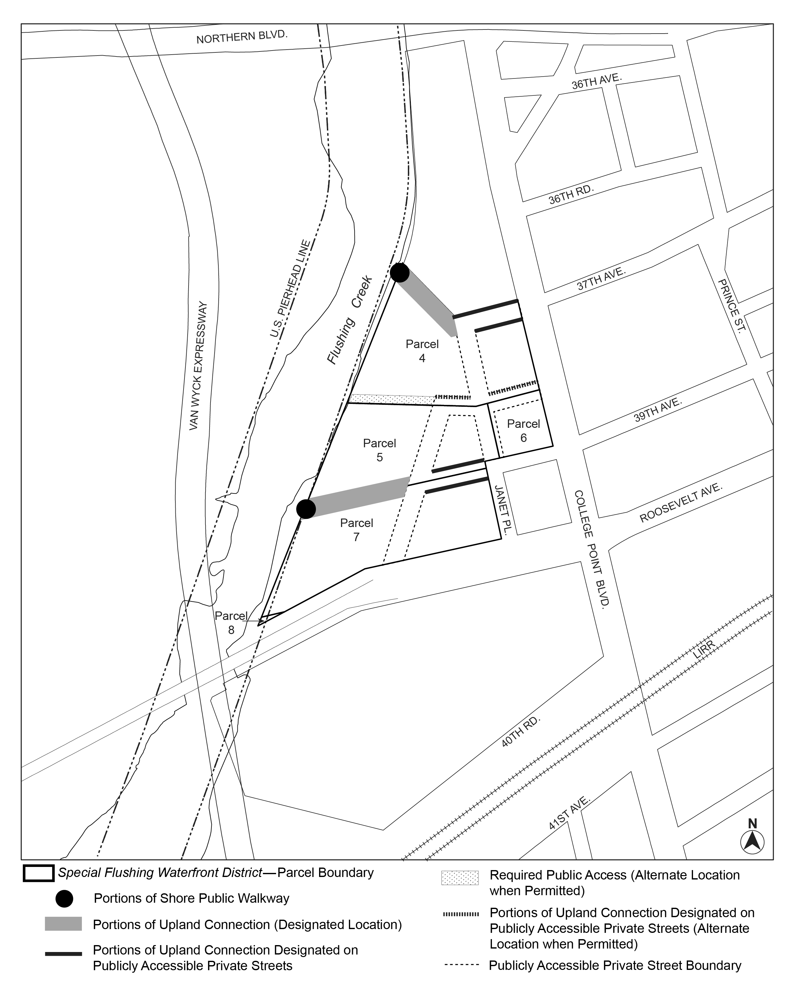
(a) the waterfront public access area shall be provided according to the phasing specified in Map 7 (Waterfront Access Plan: Phase I Waterfront Public Access Area Improvements) and Map 8 (Waterfront Access Plan: Phase II Waterfront Public Access Area Improvements). The requirements of Phase I shall apply when development occurs on the upland portion of the parcel bounded by publicly accessible private streets and other streets as shown on Map 6 (Waterfront Access Plan: Public Access Areas). The requirements of Phase II shall apply when development occurs on the seaward portion of the parcel bounded by both the shoreline and publicly accessible private streets; and
(b) any upland connection provided pursuant to Phase I shall meet the design requirements of paragraph (b) of Section 127-532 (Upland connections). For portions of the shore public walkway that are provided in Phase I, the requirements of Sections 62-53 (Requirements for Shore Public Walkways) and 62-60 (DESIGN REQUIREMENTS FOR WATERFRONT PUBLIC ACCESS AREAS) may be modified to the minimum extent necessary to accommodate a temporary waterfront viewing area.
Such phasing plan shall also be certified pursuant to Section 127-61 (Certification for Interim Grading Conditions).
Special Review Provisions
The applicable provisions of Section 62-80 (SPECIAL REVIEW PROVISIONS), inclusive, shall apply, except as specifically modified or supplemented by the provisions of this Section, inclusive.
Applicability
Supplemental provisions
In conjunction with a certification pursuant to Section 62-811 (Waterfront public access and visual corridors), the Chairperson of the City Planning Commission shall further certify that:
(a) where an upland connection is designated on two or more parcels and the portion of such upland connection located outside of the applicant’s parcel will not be constructed concurrently with the applicant’s development:
(1) if no prior certification pursuant to this Section was issued for a portion of an upland connection on another parcel, the Chairperson shall certify that:
(i) a conceptual plan has been submitted for the publicly accessible private street. In addition, notification that the applicant is seeking to commence construction of such publicly accessible private street shall be given to any other owner whose property contains any remaining portion of the publicly accessible private street, along with a copy of such conceptual plan;
(ii) a site plan has been submitted, specifying the location, dimensions and grading of the portion of the upland connection to be constructed on the applicant’s zoning lot. Such site plan shall demonstrate compliance with the requirements of paragraph (b) of Section 127-532 (Upland connections); and
(iii) the grading proposed in the conceptual plan has been certified pursuant to Section 127-61.
Property owners of the parcel containing a remaining portion of the upland connection shall have up to 30 days from the applicant’s certified mailing of the notification required in paragraph (a)(1)(i) of this Section to respond to the applicant and to confirm for the Chairperson that the construction of the entire upland connection is not feasible concurrently with the applicant’s development. In the event such notified property owners do not respond to the applicant and the Chairperson within the 30-day period, the applicant may proceed with completing this certification. Where a notified property owner responds that it is feasible to complete the portion of the upland connection on their parcels concurrently with the applicant’s development, such property owner shall commence certification pursuant to the applicable provisions of this Section within 45 days from the date of submitting such response. In the event such notified property owners do not commence such certification within the 45-day period, the applicant may proceed with completing this certification.
In addition, where construction of the upland connection will not occur concurrently, property owners of parcels containing a remaining portion of the upland connection shall have up to 45 days from the date of submitting their response to comment on any anticipated practical difficulties associated with the proposed location, dimensions and grading specified in the conceptual plan that would preclude the reasonable development of such owner’s parcel. Any submission of comments to the applicant and Chairperson shall include documentation from a licensed architect, landscape architect, or engineer, as applicable, that demonstrates the reason for such anticipated practical difficulties.
Copies of the approved conceptual plan, as well as the certified interim site plan and final site plan shall be forwarded to any property owner of a parcel containing the remaining portion of the upland connection.
Any portion of the upland connection constructed in compliance with a certified interim site plan shall be converted to the final design in compliance with the certified final site plan for such portion upon receiving notice from an adjoining property owner as set forth in paragraph (a)(2) of this Section that the remaining portion of the upland connection has been substantially completed and is accessible to the public.
(2) If a prior certification pursuant to paragraph (a)(1) of this Section was issued for a portion of the upland connection on another parcel, the Chairperson shall certify that:
(i) a final site plan for the applicant’s parcel has been submitted that is consistent with the conceptual plan from the prior certification; and
(ii) the proposed amenities and design elements within the final site plan for the applicant’s portion of the upland connection shall match or complement those that were previously constructed.
Notice shall be provided to any property owner of a parcel containing a portion of the upland connection that has been constructed pursuant to a certified interim site plan upon the applicant substantially completing its portion of the upland connection and making such portion accessible to the public. Such notice shall be provided to enable such other owner sufficient time, as shall be specified in the restrictive declaration required pursuant to this paragraph (a), to convert any constructed interim condition and complete the upland connection in compliance with the previously approved final site plan.
A restrictive declaration shall be executed and recorded against the corresponding zoning lot of the applicant’s parcel, in accordance with the provisions of Section 62-74 (Requirements for Recordation). Required site plans, the conceptual plan and a maintenance and capital repair plan for the upland connection shall be included as exhibits to the restrictive declaration.
No temporary or final certificate of occupancy shall be issued until the Chairperson of the City Planning Commission notifies the Department of Buildings that the proposed upland connection, or portion thereof, has been substantially completed in compliance with the certified interim site plan or final site plan, and is open to the public. In addition, where a property owner sought certification pursuant to paragraph (a)(2) of this Section, no temporary or final certificate of occupancy shall be issued until interim portions of the upland connection are completed in compliance with the previously approved the final site plan for such portions.
(b) For phased implementation of waterfront public access areas pursuant to Section 127-533 (Phased development of waterfront public access areas), a plan has been submitted that complies with the required amount of waterfront public access area at each development phase pursuant to Section 127-533.
To ensure the provision of waterfront public access areas for phased developments occurring in Phase I, as specified on Map 7 (Waterfront Access Plan: Phase I Waterfront Public Access Improvements) in the Appendix to this Chapter, no temporary certificate of occupancy shall be issued for any development on the upland portion of each parcel that is bounded by publicly accessible private streets or streets until all required sections of waterfront public access areas designated on Map 7 have been substantially completed pursuant to the design requirements of Section 127-533.
For Phase II subsequent development occurring on the seaward portion of Parcels 4, 5 or 7, bounded by both the shoreline and publicly accessible private streets, all remaining waterfront public access areas, as specified on Map 8 (Waterfront Access Plan: Phase II Waterfront Public Access Improvements), shall be substantially completed pursuant to the design requirements of Section 127-533, prior to the issuance of a temporary or final certificate of occupancy. However, 50 percent of the floor area of any subsequent development on Parcels 4 and 5 may receive a temporary certificate of occupancy upon the completion of the required shore public walkway as designated on such parcel. A temporary or final certificate of occupancy for the remaining 50 percent of the floor area on Parcels 4 and 5 shall not be issued until all required waterfront public access areas pursuant to Map 8 are substantially complete.
An alternate location for the required section of an upland connection on Parcel 4 may be provided in Phase I, as specified in Map 7, in the event that Parcel 5 has substantially completed all of the required waterfront public access areas prior to partial development on the upland portion of Parcel 4. Where such alternate location is provided in Phase I, any subsequent development on Parcel 4 may only receive a temporary or final certificate of occupancy upon substantial completion of all required waterfront public access areas designated on Map 8.
A certification will be granted on condition that an acceptable restrictive declaration is executed and filed pursuant to Section 62-74 (Requirements for Recordation).
For any development or enlargement seeking:
(a) modification to the level of waterfront yard provisions of Section 127-22 (Special Yard Regulations);
(b) a certification pursuant to paragraph (b)(1) of Section 127-422 (Certification for a publicly accessible private street); or
(c) a certification pursuant to Section 127-542 (Supplemental provisions),
the Chairperson of the City Planning Commission shall certify that a site survey has been conducted and sufficient documentation has been submitted, demonstrating that the proposed grades of a waterfront yard, interim plan for a publicly accessible private street or upland connection would not preclude developments or enlargements on adjacent parcels from complying with the provisions of this Chapter as part of an integrated public realm.
Appendix
Special Flushing Waterfront District Plan
Map 1. Special Flushing Waterfront District and Subdistricts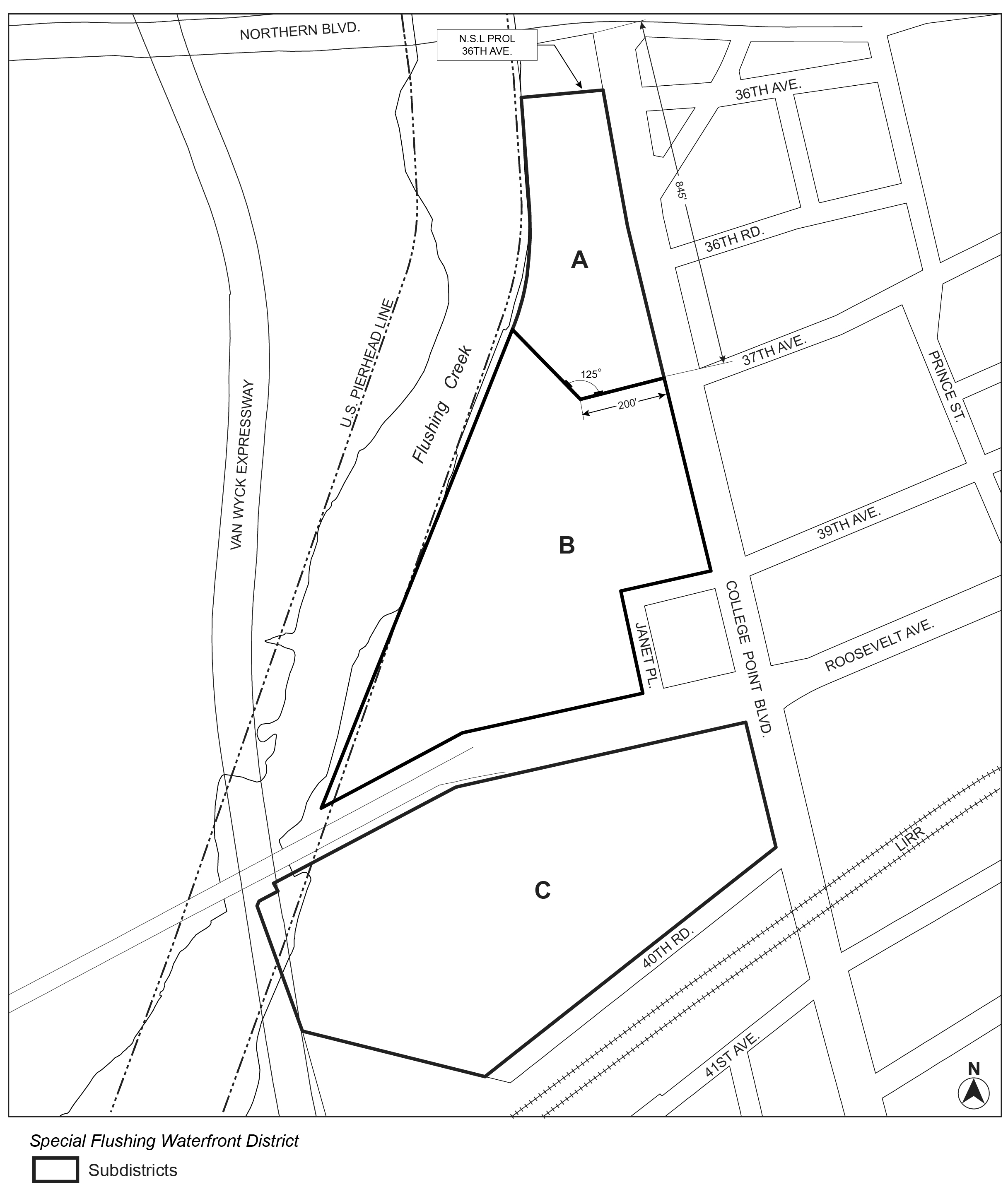
Map 2. Publicly Accessible Private Street Network
■ Map 3. Requirements Along Street Frontages
Map 4. Waterfront Access Plan: Parcel Designation
Map 5. Waterfront Access Plan: Visual Corridors
Map 6. Waterfront Access Plan: Public Access Areas
Map 7. Waterfront Access Plan: Phase I Waterfront Public Access Improvements
Map 8. Waterfront Access Plan: Phase II Waterfront Public Access Improvements