Chapter 8 - Special St. George District (SG)
GENERAL PURPOSES
The "Special St. George District" established in this Resolution is designed to promote and protect public health, safety and general welfare. These general goals include among others, the following specific purposes:
(a) to build upon St. George’s existing strengths as a civic center, neighborhood and transit hub by providing rules that will bolster a thriving, pedestrian-friendly business and residence district;
(b) to establish zoning regulations that facilitate continuous ground floor retail and the critical mass needed to attract and sustain a broader mix of uses;
(c) to require a tall, slender building form that capitalizes on St. George’s hillside topography and maintains waterfront vistas;
(d) to encourage the reuse and reinvestment of vacant office buildings;
(e) to accommodate an appropriate level of off-street parking while reducing its visual impact;
(f) to enhance neighborhood economic diversity by broadening the range of housing choices for residents at varied incomes; and
(g) to promote the most desirable use of land and building development in accordance with the District Plan for St. George and thus conserve the value of land and buildings and thereby protect the City’s tax revenues.
Definitions
General Provisions
In harmony with the general purpose and intent of this Resolution and the general purposes of the Special St. George District, the regulations of this Chapter shall apply within the Special St. George District. The regulations of all other Chapters of this Resolution are applicable, except as superseded, supplemented or modified by the provisions of this Chapter. In the event of a conflict between the provisions of this Chapter and other regulations of this Resolution, the provisions of this Chapter shall control. However, in flood zones, or for transit-adjacent sites, as defined in Section 66-11 (Definitions), in the event of a conflict between the provisions of this Chapter and the provisions of Article VI, Chapter 4 (Special Regulations Applying in Flood Hazard Areas), or Article VI, Chapter 6 (Special Regulations Applying Around Mass Transit Stations), the provisions of Article VI shall control.
However, the regulations of this Chapter shall not apply to any property that is the subject of a site selection for a court house and public parking garage pursuant to application C080379 PSR. Such property shall be governed by the underlying regulations of this Resolution.
Furthermore, any property that is the subject of a site selection and acquisition for the use of a lot for open parking pursuant to application C080378 PCR may be governed by the regulations of this Chapter or the underlying regulations of this Resolution for a period of two years after October 23, 2008. After October 23, 2010, such property shall be subject to the regulations of this Chapter.
In the North Waterfront Subdistrict, “publicly accessible waterfront open space” shall include on-site and off-site areas, as applicable, as set forth in the approved Proposed Plans, pursuant to Section 128-61 (Special Permit for North Waterfront Sites).
District Plan and Maps
The regulations of this Chapter are designed to implement the Special St. George District Plan.
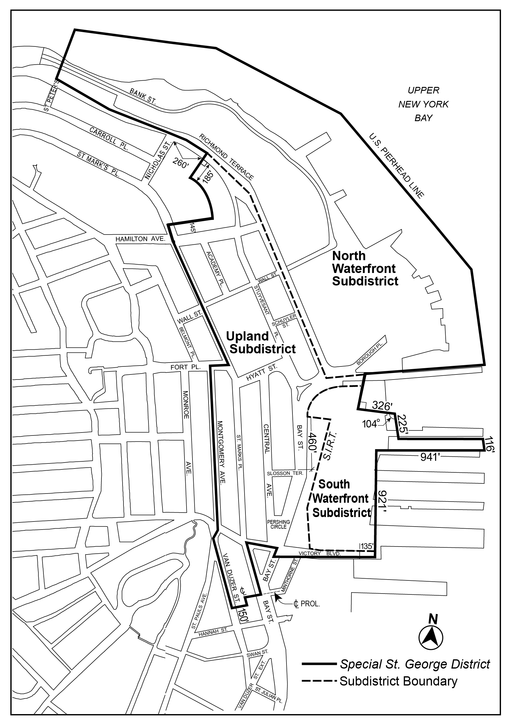
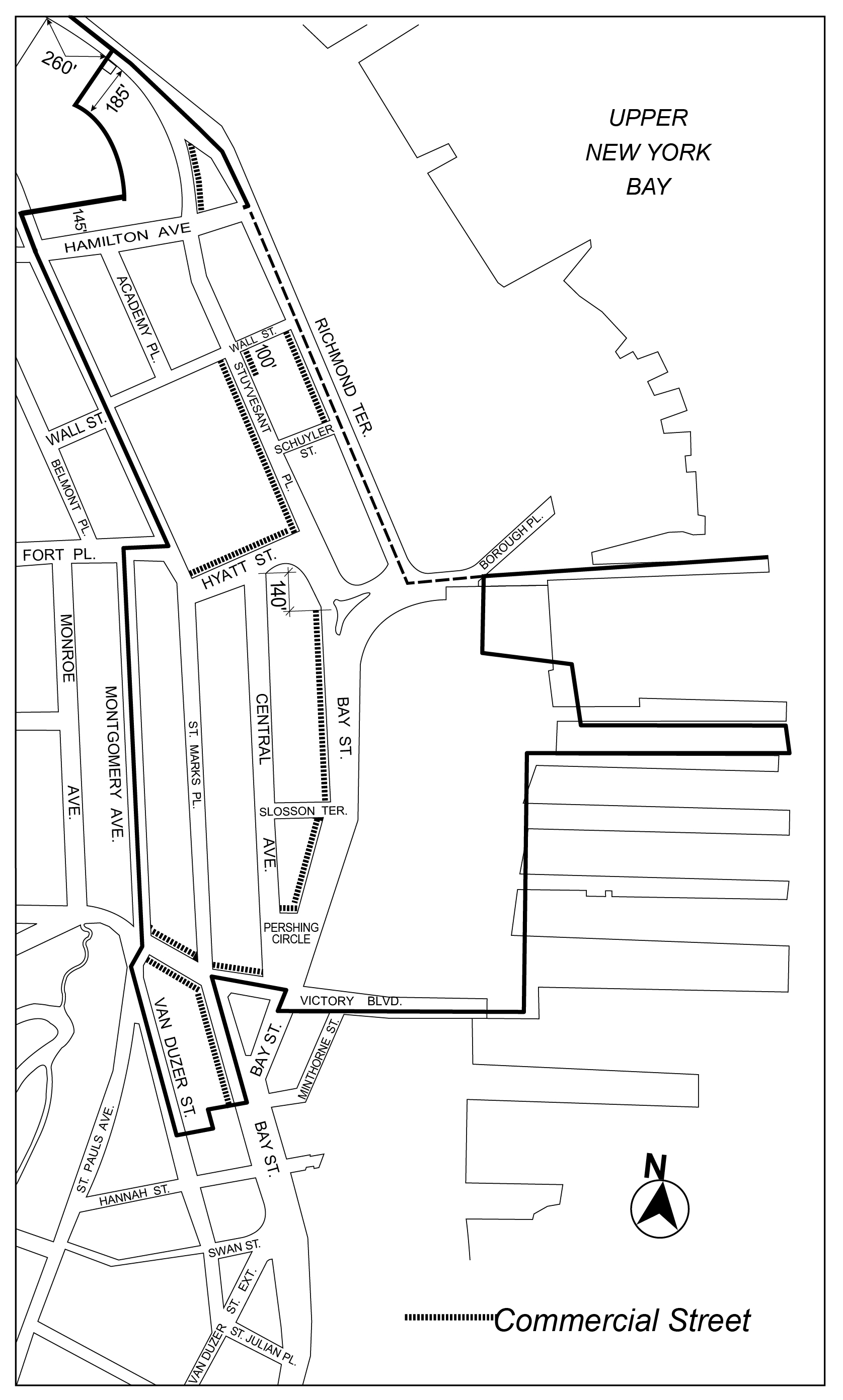
The District Plan includes the following five maps:
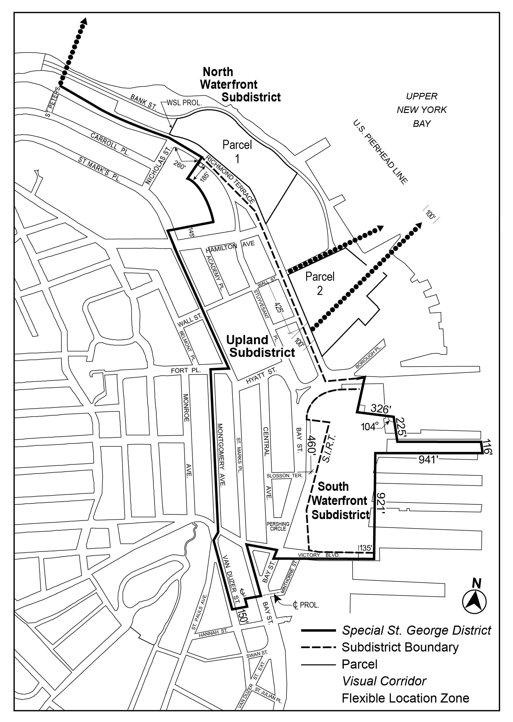
Map 1. Special St. George District and Subdistricts
Map 2. Designated Street Frontages
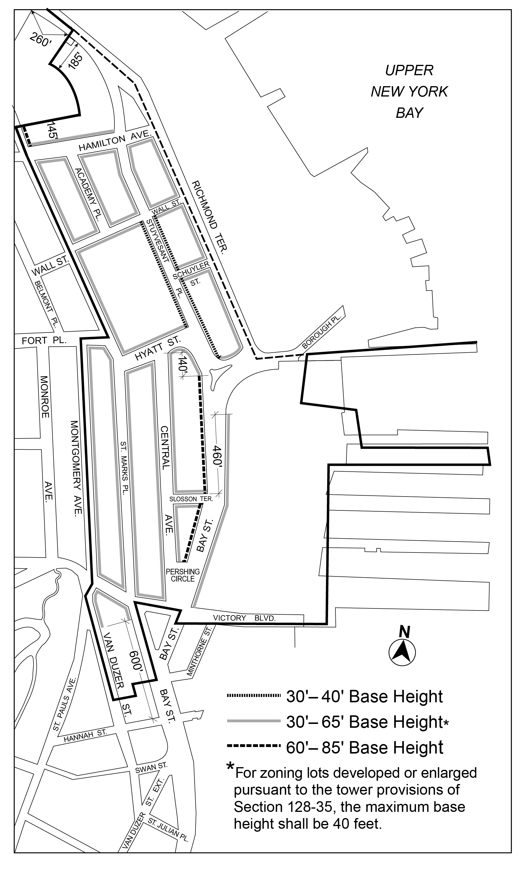
Map 3. Minimum and Maximum Base Heights
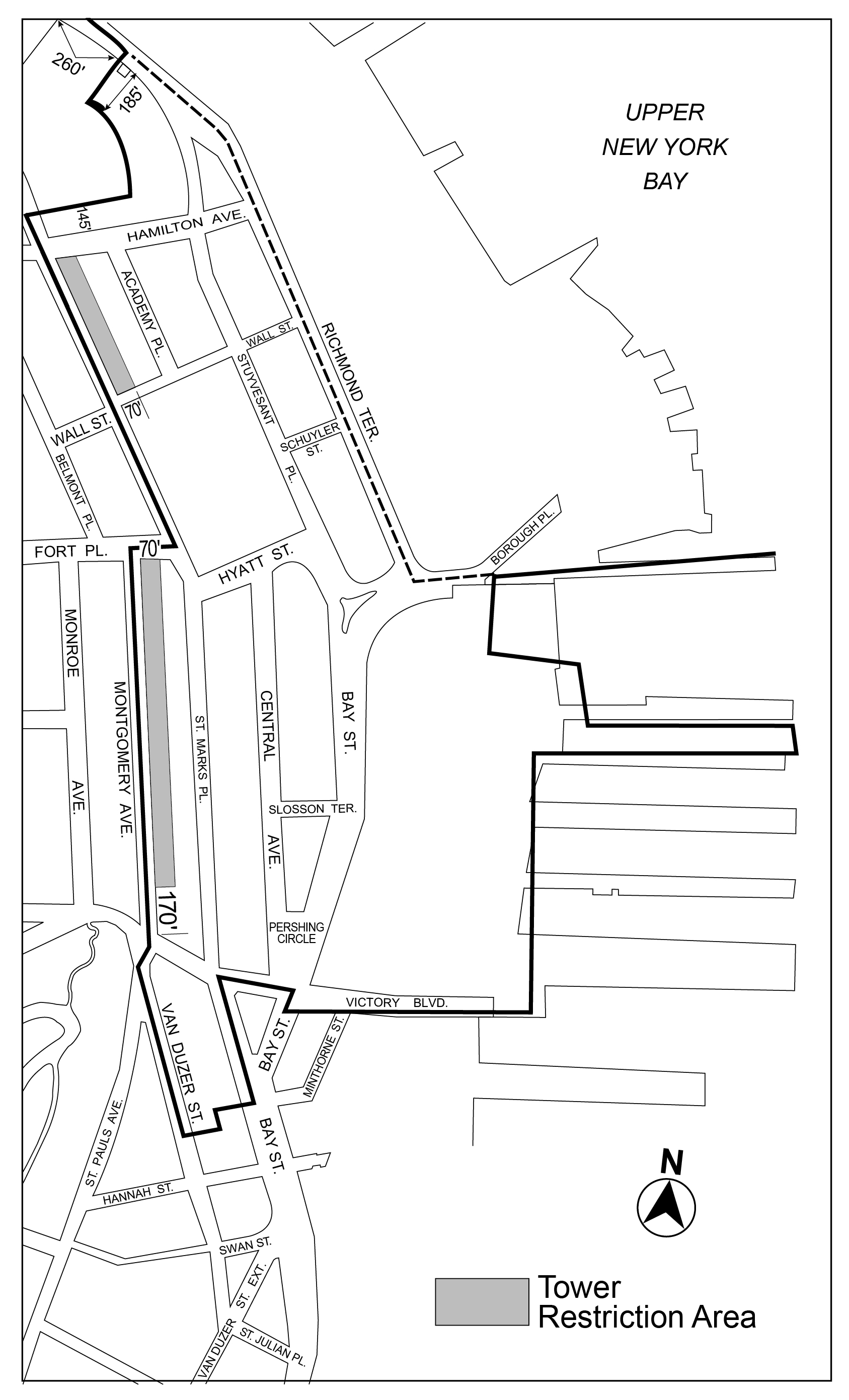
Map 4. Tower Restriction Areas
Map 5. Visual Corridors and Parcels
The maps are located in the Appendix to this Chapter and are hereby incorporated and made a part of this Resolution. They are incorporated for the purpose of specifying locations where special regulations and requirements set forth in this Chapter apply.
Subdistricts
In order to carry out the purposes and provisions of this Chapter, the Special St. George District shall include three subdistricts: the Upland Subdistrict, the North Waterfront District and the South Waterfront Subdistrict, as shown on Map 1 (Special St. George District and Subdistricts) in the Appendix to this Chapter.
The definition of “lower density growth management area” in Section 12-10 (DEFINITIONS) shall be modified to exclude all districts within the Special St. George District.
The provisions of Section 36-76 (Waiver or Reduction of Spaces for Subsidized Housing) shall not apply in the Special St. George District.
The provisions of Article VI, Chapter 2 (Special Regulations Applying in the Waterfront Area), shall apply in the North Waterfront Subdistrict of the Special St. George District, as modified in this Chapter. In such Subdistrict, such provisions shall not apply to improvements to the publicly accessible waterfront open space, or to developments, enlargements, alterations and changes of use permitted pursuant to Section 128-61 (Special Permit for North Waterfront Sites). However, the regulations of Section 62-31 (Bulk Computations on Waterfront Zoning Lots) shall apply to such developments, enlargements, alterations and changes of use, as modified pursuant to such special permit. In addition, the special requirements for visual corridors set forth in Section 128-43 (Visual Corridors in the North Waterfront Subdistrict) shall apply.
Within the North Waterfront Subdistrict of the Special St. George District, the following special permits shall not apply:
Section 74-194 (Public parking garages or public parking lots outside high density areas)
Section 74-61 (Development on Lots that Include Railroad Right-of-Ways).
In addition, the provisions of the following special permits, as applicable, shall be deemed to be modified when an application pursuant to Section 128-61 (Special Permit for North Waterfront Sites) for Parcel 1 or Parcel 2, as shown on the maps in the Appendix to this Chapter, under application numbers C130317ZSR or C130318ZSR, as applicable, has been approved:
C000012ZSR
C000013ZSR
C000014ZSR
C000016(A)ZSR
Within the North Waterfront Subdistrict of the Special St. George District, the following authorization by the City Planning Commission and certifications by the Chairperson of the City Planning Commission, shall not apply:
Section 75-411 (Developments on or over railroad rights-of-way)
Section 75-412 (Developments on lots under one and a half acres that include railroad right-of-ways)
USE REGULATIONS
Streetscape Regulations
The underlying ground floor level streetscape provisions set forth in Section 32-30 (STREETSCAPE REGULATIONS), inclusive, shall apply, except that:
- ground floor level street frontages along streets, or portions thereof, designated on Map 2 (Designated Street Frontages) in the Appendix of this Chapter shall be considered Tier C street frontages, and
- remaining ground floor level street frontages shall be considered Tier B street frontages. However, in lieu of the parking wrap and enclosure provisions of Section 32-32, inclusive, the provisions for Tier A street frontages set forth in Section 32-312 (Ground floor level parking restrictions) may be applied.
The provisions of Section 32-422 (Location of floors occupied by commercial uses) shall be modified such that the limitations set forth in paragraph (a) of such Section need not apply, and the requirements in paragraph (b) of such Section shall apply only where commercial uses are located above any story containing dwelling units. In addition, the provisions of paragraph (d) of Section 32-422 shall be modified such that eating or drinking establishments listed under Use Group VI shall be permitted on a story above dwelling units.
The underlying floor area ratio and yard regulations shall apply, except as modified pursuant to the provisions of this Section, inclusive.
Maximum Floor Area Ratio
In C4-2 Districts within the Upland Subdistrict, the maximum floor area ratio shall be modified as follows:
- for zoning lots with less than 10,000 square feet of lot area without frontage on a commercial street, the maximum floor area ratio for any use, separately or in combination, shall be 2.2. However, for qualifying affordable housing or qualifying senior housing, the maximum floor area ratio shall be 2.64. No floor area bonuses shall apply; or
- for all other zoning lots, the maximum floor area ratio for any use, separately or in combination, shall be 3.4. However, for qualifying affordable housing or qualifying senior housing, the maximum floor area ratio shall be 4.08. No floor area bonuses shall apply.
Rear Yard Equivalents
In C4-2 Districts within the Upland Subdistrict, the rear yard equivalent regulations for residential uses on through lots, or the through lot portion of a zoning lot, are modified as set forth in this Section. Such yards shall be provided within 45 feet of the centerline of the through lot or through lot portion, and the level of such yards may be provided at any level not higher than the floor level of the lowest story containing dwelling units that face such yards. Furthermore, no rear yard equivalent regulations shall apply to any through lot or through lot portion of a zoning lot on which a tower is developed or enlarged, pursuant to Section 128-35.
In the Upland Subdistrict, underlying height and setback regulations shall apply, except as modified pursuant to the provisions of this Section, inclusive.
In the South and North Waterfront Subdistricts, the underlying height and setback regulations of Section 62-34 (Height and Setback Regulations on Waterfront Blocks) shall apply, except that:
- in the South Waterfront Subdistrict, permitted obstructions shall be allowed pursuant to Section 128-31 (Permitted Obstructions); and
- in the North Waterfront Subdistrict, developments, enlargements, alterations and changes of use permitted pursuant to Section 128-61 (Special Permit for North Waterfront Sites) shall instead be subject to the Proposed Plans, as set forth in Section 128-61, as approved pursuant to such special permit.
All heights shall be measured from the base plane, except that wherever a minimum or maximum base height is specified for zoning lots with multiple street frontages, such heights shall be determined separately for each street frontage, with each height measured from the final grade of the sidewalk fronting such street wall.
Permitted Obstructions
The provisions of Section 33-42 (Permitted Obstructions) shall apply to all buildings, except that dormers may penetrate a maximum base height in accordance with the provisions of paragraph (b)(1) of Section 23-413 (Permitted obstructions in certain districts). However, where towers are provided in accordance with Section 128-35 (Towers), the allowance in paragraph (f) of such Section shall supersede the underlying dormer provisions.
Street Wall Location
The following street wall location provisions shall apply:
- Street walls along designated street frontages
For street walls fronting streets designated on Map 2 (Designated Street Frontages) in the Appendix to this Chapter, the street wall location provisions of paragraph (b) Section 35-631 shall apply. - Street walls along other streets
For street walls fronting other streets, the street wall shall extend along at least 50 percent of the street frontage of the zoning lot and be located within eight feet of the street line or sidewalk widening line, whichever is applicable.
Such street walls shall rise without setback to the minimum height specified on Map 3 (Minimum and Maximum Base Heights) in the Appendix to this Chapter, or the height of the building, whichever is less. When a building fronts on two intersecting streets for which different minimum base heights apply, the higher base height may wrap around to the street with the lower base height, for a distance of up to 100 feet.
Maximum Base Height
The maximum height of a building or other structure before setback shall be as specified on Map 3 (Minimum and Maximum Base Heights) in the Appendix to this Chapter. When a building fronts on two intersecting streets for which different maximum base heights apply, the higher base height may wrap around to the street with the lower base height for a distance of up to 100 feet. At a height not lower than the minimum base height, and not higher than the maximum base height, a setback shall be provided in accordance with the provisions of Section 23-433 (Standard setback regulations).
Maximum Building Height
After the required setback, a building may rise to the maximum building height set forth in Section 23-43 (Height and Setback Requirements in R6 Through R12 Districts), inclusive, for the applicable residential equivalent. However, in C4-2 Districts, towers shall be permitted as an alternative to such maximum building height, where provided in accordance with the provisions of Section 128-35 (Towers).
Towers
In C4-2 Districts, tower provisions of this Section shall apply, as an option, to any zoning lot with a lot area of at least 10,000 square feet. Any portion of a building developed or enlarged on such zoning lots that exceeds the applicable maximum base height shall comply with the following:
- Maximum footprint
Each story located entirely above the maximum base height shall not exceed a gross area of 10,000 square feet. The outermost walls of each such story shall be inscribed within a rectangle, and the maximum length of any side of such rectangle shall be 135 feet. - Tower top articulation
The highest three stories shall have a lot coverage of at least 50 percent of the story located directly below such stories, provided that the gross area of any such story does not exceed 90 percent of the gross area of that story located directly below such stories. - Orientation of all towers
The maximum length of the outermost walls of any side of each story of a tower facing the shoreline shall not exceed 80 feet. For the purposes of this Section, the street line of St. Marks Place shall be considered to be a line parallel to the shoreline, and any side of such rectangle facing St. Marks Place from which lines perpendicular to the street line of St Marks Place may be drawn, regardless of intervening structures, properties or streets, shall not exceed 80 feet. - Location of all towers
Any portion of a tower shall be no closer to a side lot line than eight feet, and any story of a building that is entirely above a height of 70 feet shall be located within 25 feet of a street line or sidewalk widening line, where applicable. - Maximum tower height
The maximum height of any building utilizing the tower provisions of this Section shall be 200 feet. The height of the tower portion of the building shall be measured from the base plane. - Tower and base integration
The underlying setback provisions may be modified as follows: up to 50 percent of the street wall of the tower portion of the building need not be set back from the street wall of the building, and may rise without setback from grade, provided such portion of the building is set back at least 10 feet from a wide street line or sidewalk widening line, where applicable, and at least 15 feet from a narrow street line or sidewalk widening line, where applicable. On frontages where such allowance is taken, no dormers shall be permitted. - Tower exclusion areas
No towers shall be permitted within the areas designated on Map 4 (Tower Restriction Areas) in the Appendix to this Chapter.
MANDATORY IMPROVEMENTS
Sidewalks
Sidewalks with a depth of at least 12 feet, measured perpendicular to the curb of a street, shall be provided along the entire street frontage of a zoning lot. In locations where the width of the sidewalk within the street is less than 12 feet, a sidewalk widening shall be provided on the zoning lot so that the combined width of the sidewalk within the street and the sidewalk widening equals 12 feet. However, existing buildings to remain on the zoning lot need not be removed in order to comply with this requirement. All sidewalk widenings shall be improved to Department of Transportation standards for sidewalks, shall be at the same level as the adjoining public sidewalks, and shall be accessible to the public at all times.
The designated locations for visual corridors, as defined in Article VI, Chapter 2, are shown on Map 5 in the Appendix to this Chapter. Such visual corridors shall be provided in accordance with the standards of Sections 62-512 (Dimensions of visual corridors) and 62-513 (Permitted obstructions in visual corridors), except that:
- lighting fixtures in visual corridors shall be considered permitted obstructions; and
- within the visual corridor provided through Parcel 2 to the Pierhead line within the flexible location zone indicated on Map 5, a portion of a building shall be a permitted obstruction, provided that such obstruction is located no more than 14 feet above the reference plane of the visual corridor, and that such obstruction occupies no more than 185,000 cubic feet in total above the reference plane of the visual corridor.
PARKING REGULATIONS
In the Special St. George District, the underlying regulations governing permitted and required accessory off-street parking spaces are modified as set forth in this Section.
In the Special St. George District, the following modifications to underlying parking and loading regulations shall apply:
In C4-2 Districts:
- For commercial uses, the off-street parking and loading requirements of a C4-3 District shall apply, except that grocery and convenience retailers listed under Use Group VI with 2,500 or more square feet of floor area per establishment shall require one parking space per 400 square feet of floor area and, for uses subject to PRC-B or PRC-F off-street parking requirements, the requirements of a C4-2 District shall apply.
- For ambulatory diagnostic or treatment health care facilities listed under Use Group III, the off-street parking requirements of a C4-3 District shall apply.
The floor area of a building shall not include floor space used for off-street parking spaces provided in any story that complies with the provisions of Section 128-54 (Location of Accessory Off-street Parking Spaces).
Use of Parking Facilities
All accessory off-street parking spaces may be provided within parking facilities, including public parking garages, on zoning lots other than the same zoning lot as the use to which they are accessory, provided:
(a) such parking facilities are located within the Special St. George District ;
(b) the off-street parking space within such facility is counted only once in meeting the parking requirements for a specific zoning lot ; and
(c) the number of accessory parking spaces within such facility shall not exceed the combined number of spaces permitted on each zoning lot using such facility, less the number of spaces provided on each zoning lot using such facility.
The roof of a facility containing off-street parking spaces, not otherwise covered by a building, which is larger than 400 square feet, shall be landscaped. No parking spaces shall be provided on the roof of such facility. Up to five percent of such roof area may be used for mechanical equipment, provided that such mechanical equipment is screened from view by a fence which is at least 75 percent opaque or by at least three feet of dense planting. No less than 75 percent of such roof area shall be accessible for the recreational use of the occupants of the building in which it is located; and no more than 25 percent may be accessible solely from an adjacent dwelling unit. Hard surfaced areas shall not cover more than 60 percent of such roof area.
No curb cuts shall be permitted on streets designated on Map 2 in the Appendix to this Chapter. However, if access to a required accessory parking facility or loading berth is not possible because of such restriction, a curb cut may be allowed if the Chairperson of the City Planning Commission certifies to the Commissioner of Buildings that such location is the only possible location for the facility or loading berth, is not hazardous to traffic safety, is at least 50 feet from the intersection of two street lines, and is constructed so as to have minimal effect on the streetscape.
SPECIAL APPROVALS
The special permit for North Waterfront sites set forth in Section 128-61 is established in order to guide and encourage appropriate use and development in a unique location within the Special St. George District that serves as a gateway between Staten Island and Manhattan for both visitors and daily commuters. Redevelopment of the North Waterfront sites pursuant to this special permit provides an appropriate means to address the special characteristics of these sites, while accommodating their continuing transportation function, as part of their transformation into a regional destination that will contribute to the revitalization of the Special St. George District and surrounding area.
The special permit for buildings in R7-3 Districts set forth in Section 128-62 is established to allow modification of bulk regulations and mandatory improvements, except floor area ratio provisions, in order to encourage better site planning, and streetscapes that are consistent with the goals of the Special District.
In the North Waterfront Subdistrict, for Parcels 1 and 2, and for improvements to the publicly accessible waterfront open space, provided in connection with the development of such parcels, as applicable, the City Planning Commission may approve, by special permit, a development plan for each such parcel and an improvement plan for the publicly accessible waterfront open space. For any application for such special permit, the applicant shall provide plans to the Commission, including but not limited to a site plan, interim parking plan, signage plan, lighting plan and an improvement plan for the publicly accessible waterfront open space (the “Proposed Plans”). Such Proposed Plans shall be subject to the conditions set forth in paragraphs (a) through (e) and the findings set forth in paragraph (f) of this Section.
Pursuant to such Proposed Plans, the Commission may:
(a) permit the following use modifications:
(1) commercial uses listed under Use Group VI, with a size limitation, as denoted in the Use Group table with an “S”, may be permitted without size limitation;
(2) outdoor amusement parks listed under Use Group VIII may be permitted without size limitation;
(3) public parking garages with more than 150 spaces may be permitted;
(4) temporary public parking lots or public parking garages with more than 150 spaces, supplied in connection with an interim parking plan, may be permitted, provided that:
(i) the applicable findings of Section 74-51 Public Parking Garages of Public Parking Lots Outside High Density Central Areas) are met by each such temporary public parking facility;
(ii) such temporary public parking lots or public parking garages with more than 150 spaces, may be located off-site or beyond the boundaries of the Special St. George District only as set forth in the interim parking plan. Any change in the location of such temporary public parking facility with more than 150 spaces, or any increase in the number of spaces in a temporary public parking facility to more than 150 spaces, or any addition of a public parking facility with more than 150 spaces provided in connection with such interim parking plan, shall be subject to further approval by the City Planning Commission and referred to the applicable Community Board(s) for review; and
(iii) the permit to operate such public parking lots or public parking garages shall expire 30 days after the Department of Buildings issues a certificate of occupancy for all permanent public parking facilities on Parcel 2;
(b) where such development is located partially or entirely on or over a railroad right-of-way or former railroad right-of-way:
(1) permit that portion of the railroad right-of-way which will be completely covered over by a permanent platform to be included in the calculations of lot area for such development ; and
(2) establish, in lieu of base plane, an appropriate level or levels as the reference plane for the entire zoning lot for the applicable regulations pertaining to, but not limited to, height and setback, floor area and yards;
(c) permit signs pursuant to a signage plan, subject to the following conditions:
(1) the sign regulations of a C4 District, as set forth in Section 32-60, shall apply, except as specifically modified by the conditions set forth in paragraphs (c)(2) through (c)(7), inclusive, of this Section;
(2) flashing signs shall not be permitted;
(3) the height of signs shall be measured from the base plane;
(4) flags, banners or pennants, other than those that are advertising signs, shall be permitted without limitation;
(5) on Parcel 1:
(i) the total surface area of a sign affixed to a building frontage facing the shoreline or affixed to the base of a structure facing the shoreline shall not exceed 1,120 square feet, provided that for a sign with a surface area larger than 500 square feet, all writing, pictorial representations, emblems, flags, symbols or any other figure or character comprising the design of such sign, shall be separate elements, individually cut and separately affixed to the structure. No perimeter or background surfaces shall be applied or affixed to the structure in addition to such separate elements. No portion of such separate elements shall extend beyond the maximum dimensions allowed for the structure; and
(ii) signs shall be permitted to be located on the deck of the railroad right-of-way, provided that the surface area of such signs shall be included in the calculations of total surface area of signs;
(6) on Parcel 2:
(i) open pedestrian pathways of at least 20 feet in width shall be considered streets for the purposes of sign regulations;
(ii) signs shall not extend to a height greater than 60 feet above the base plane; and
(iii) the total surface area of signs on the building frontage facing Richmond Terrace, the prolongation of Wall Street, or on the building frontage or other structure facing the access route into the Ferry Terminal for buses, may exceed the limitations for total surface area for signs permitted in a C4 District, pursuant to an approved signage plan; and
(7) the total surface area of all signs on Parcel 2 facing the shoreline, or that are within 15 degrees of being parallel to the shoreline, shall not exceed:
(i) 500 square feet for signs located above the level of the first story ceiling of buildings; or
(ii) 250 square feet for signs located below the level of the first story ceiling of buildings;
(d) through approval of the Proposed Plans, establish appropriate requirements in lieu of the following Special St. George District regulations:
Section 128-11 (Streetscape Regulations);
Section 128-54 (Special Requirements for Roofs of Parking Facilities); and
(e) through approval of the Proposed Plans:
(1) establish appropriate requirements for the height and setback of buildings or other structures, permitted obstructions in yards, off-street parking and loading; and
(2) permit floor area to be distributed within the North Waterfront Subdistrict without regard for zoning lot lines, provided that if distribution is made to a zoning lot, subject to a special permit granted under this Section, from a zoning lot not subject to such special permit, Notices of Restriction in a form acceptable to the Department of City Planning shall be filed against such zoning lots setting forth the increase and decrease in the floor area on such zoning lots, respectively.
(f) The Commission shall find that the Proposed Plans:
(1) include uses that are appropriate, considering the unique location of the site in relation to the Staten Island Ferry Terminal, the Staten Island Rail Road, and the land uses in and around the Special St. George District;
(2) provide a distribution of floor area, locations and heights of buildings or other structures, primary business entrances and open areas, that will result in a superior site plan, providing a well-designed relationship between buildings and other structures and open areas on the zoning lot; and shall also provide a well-designed relationship between the site and adjacent streets, surrounding buildings, adjacent off-site open areas and shorelines and will thus benefit the users of the site, the neighborhood and the City as a whole;
(3) provide a distribution of floor area and locations and heights of buildings or other structures that will not unduly increase the bulk of buildings or other structures in the North Waterfront Subdistrict or unduly obstruct access of light and air to the detriment of the users of the site or nearby blocks or of people using the public streets, and that will provide waterfront vistas from nearby streets and properties on nearby blocks;
(4) provide useful and attractive publicly accessible open space, with sufficient public amenities, including but not limited to seating, landscaping and lighting, that results in a superior relationship with surrounding neighborhood destinations, streets, buildings, open areas, public facilities and the waterfront;
(5) improve public access to the waterfront;
(6) improve, as applicable, the publicly accessible waterfront open space sufficiently to ensure that emergency vehicles will have adequate access to the waterfront and adjacent developments;
(7) in connection with the improvement of the applicable portions of the publicly accessible waterfront open space, restore planted areas, trees and lighting in a way that is attractive and compatible with the design of the Waterfront Esplanade existing on October 30, 2013;
(8) provide adequate parking and loading to meet the demand for all users during peak utilization;
(9) provide adequate parking for commuters at locations convenient and accessible to the Staten Island Ferry Terminal at all times and during all phases of construction;
(10) provide signage and lighting that are compatible with the scenic and historic character of the harbor and that will not adversely affect the character of the surrounding neighborhood;
(11) for a public parking garage with more than 150 parking spaces, will ensure that:
(i) entrances are proposed in locations and with design features that minimize traffic congestion and conflicts with pedestrians;
(ii) adequate reservoir space has been provided at the vehicular entrances; and
(iii) the streets providing access to such use will be adequate to handle the traffic generated thereby; and
(12) for a development located partially or entirely on or over a railroad right-of-way or former railroad right-of-way
(i) the distribution of floor area does not adversely affect the character of the surrounding area by being unduly concentrated in any portion of such development, including any portion of the development located beyond the boundaries of such railroad right-of-way; and
(ii) if such railroad right-of-way is deemed appropriate for future transportation use, the site plan and structural design of the development do not preclude future use of, or improvements to, the right-of-way for such transportation use.
The Commission may prescribe appropriate conditions and safeguards to minimize adverse effects on the character of the surrounding area. In addition, for a development located partially or entirely on or over a railroad right-of-way, the Commission may require that the structural design of such development makes due allowance for changes within the layout of tracks or other structures within any railroad right-of-way which may be deemed necessary in connection with future development or improvement of the transportation system.
Prior to granting a special permit, the Commission shall request the Metropolitan Transportation Authority to indicate whether said agency has any plan to use that portion of any former railroad right-of-way.
The execution and recordation of a restrictive declaration acceptable to the Commission, binding the owners, successors and assigns to maintain such developments, enlargements, alterations, changes of use, and any temporary parking facilities, in accordance with the approved Proposed Plans, and in a manner consistent with any additional conditions and safeguards prescribed by the Commission, shall be a condition to exercise of the special permit. Such restrictive declaration shall be recorded in the Office of the County Clerk. A copy of such declaration shall be provided to the Department of Buildings upon application for any building permit related to a development, enlargement or change of use.
For any zoning lot in an R7-3 District, the City Planning Commission may permit modification of bulk regulations, except floor area ratio provisions, and modification of mandatory improvements, provided the Commission shall find that such modifications:
(a) will aid in achieving the general purposes and intent of the Special District;
(b) will enhance the distribution of bulk on the zoning lot;
(c) will not unduly obstruct access to light and air from surrounding streets and properties; and
(d) will result in a better site plan and urban design relationship with adjacent streets, open areas, and the surrounding neighborhood.
The Commission may prescribe additional conditions and safeguards to minimize adverse effects on the character of the surrounding area.