Chapter 1 - Special Regulations Applying Around Major Airports
GENERAL PROVISIONS
The maximum height of buildings or other structures shall be regulated by the special controls set forth in this Chapter established pursuant to the authority conferred under Article 14 of the General Municipal Law, in order to prevent the construction of obstructions to air navigation in the vicinity of major airports, and thus to protect the lives and property of persons residing within such vicinity and of persons in airplanes which are approaching, taking off from, or circling such airports, thereby promoting public health, safety, and general welfare.
The definitions applicable to this Chapter are set forth in Section 61-30.
The major airports are hereby designated to include John F. Kennedy International, LaGuardia, and U.S. Naval Air Station (Floyd Bennett Field). For the purposes of this Chapter, the runways for such airports shall be the runways as shown in the diagrams in Section 61-42 (Runways for Major Airports).
A flight obstruction area is hereby established in the vicinity of any such major airport.
Each flight obstruction area shall be divided into two parts, the Airport Approach District and the Airport Circling District, as described in this Section (and as shown, for convenient reference only, in the flight obstruction area maps available on request at the offices of the City Planning Commission).
Airport Approach District
The Airport Approach District comprises those parts of the flight obstruction area of any major airport which lie generally below the flight path of aircraft approaching or taking off from the runways of such airport, and, more specifically, below the following airport referenced imaginary surfaces: the approach surfaces, the transitional surfaces and those parts of the horizontal surface and the conical surface which coincide with such approach surfaces and transitional surfaces.
Airport Circling District
The Airport Circling District comprises those parts of the flight obstruction area of any major airport which lie generally below the flight path of aircraft circling such airport and, more specifically, below the following airport referenced imaginary surfaces: those parts of the horizontal surface and the conical surface which do not coincide with the approach surfaces and the transitional surfaces.
HEIGHT RESTRICTIONS
Notwithstanding any other provisions of this Resolution, except as provided in Section 61-22 (Permitted Projection within any Flight Obstruction Area), the highest projection of any building or other structure hereafter constructed or of any existing building or other structure hereafter relocated, enlarged or reconstructed shall not penetrate:
(a) the approach surfaces, the transitional surfaces, the horizontal surface, or the conical surface, whichever is more restrictive, within the Airport Approach District of the flight obstruction area; and
(b) the horizontal surface or the conical surface within the Airport Circling District of the flight obstruction area.
However, within a flight obstruction area, the highest projection of any such building or other structure may, in any event, extend to a height of 30 feet above curb level.
DEFINITIONS
Airport reference point (or points)
The "airport reference point" (or "points") is a point (or points) within the boundaries of each major airport, as indicated on the flight obstruction area maps for each such major airport. The point or points applicable to each major airport are set forth in Section 61-41 (Airport Reference Point, Established Elevation and Specified Radii).
Airport referenced imaginary surfaces
"Airport referenced imaginary surfaces" include the horizontal surface, the conical surface, the approach surfaces and the transitional surfaces.
Approach surfaces
The "approach surfaces" are imaginary inclined planes, trapezoidal in shape and located symmetrically with respect to the extended center line of any runway. Such approach surfaces, extending from both ends of any runway, consist of contiguous inner and outer sections whose dimensions are as follows:
(a) The plane of the inner section:
(1) begins at a line drawn parallel to, and at the same elevation as, the end of the runway, and at a distance, measured horizontally along the extended runway centerline, of 200 feet from the end of the runway;
(2) extends for a distance of 10,000 feet, measured horizontally along the extended runway centerline;
(3) has a width of 1,000 feet measured along the line described in paragraph (a)(1) of this Section, which increases uniformly (with respect to the extended runway centerline) to a width of 4,000 feet at the outer edge of such inner section, as described in paragraph (a)(2) of this Section; and
(4) rises at a slope of one foot in height for every 50 feet of horizontal distance.
(b) The plane of the outer section:
(1) begins at the outer edge of the inner section;
(2) extends for a distance of 15,000 feet, measured horizontally along the extended runway centerline;
(3) has a width of 4,000 feet commencing at the outer edge of the inner section, which increases uniformly (with respect to the extended runway center line) to a width of 8,500 feet at the outer edge of such outer section; and
(4) rises at a slope of one foot in height for every 40 feet of horizontal distance.
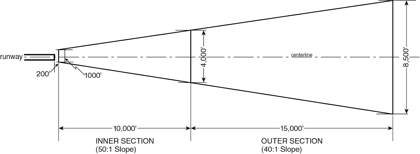
DESCRIPTION OF APPROACH SURFACE
Conical surface
The "conical surface" is an imaginary inclined surface extending upward and outward from the periphery of the horizontal surface, which:
(a) rises at a slope, measured in an imaginary vertical plane passing through the airport reference point (or points), of one foot for every 20 feet in horizontal distance; and
(b) is measured on a horizontal radius from the airport reference point (or points), and extends for a distance set forth in Section 61-41 (Airport Reference Point, Established Elevation and Specified Radii).
Established airport elevation
The "established airport elevation" is the elevation above mean sea level of the highest point of the usable airport landing area for any major airport. The elevation applicable to each major airport is set forth in Section 61-41 (Airport Reference Point, Established Elevation and Specified Radii).
Flight obstruction area
The "flight obstruction area" comprises all areas of land or water below the airport referenced imaginary surfaces for each airport.
Horizontal surface
The "horizontal surface" is an imaginary horizontal plane, circular or elliptical in shape, which:
(a) is located at a height of 150 feet above the established airport elevation for any major airport; and
(b) is measured on a horizontal radius from the airport reference point (or points), and extends for a distance set forth in Section 61-41 (Airport Reference Point, Established Elevation and Specified Radii).
Transitional surfaces
The "transitional surfaces" are imaginary inclined planes extending upward and outward from the side edges of all approach surfaces, and from lines parallel to, 500 feet from, and at the same level as the center line of each runway, which:
(a) rise at a slope of one foot in height for every seven feet of horizontal distance measured in a vertical plane at right angles to the center line of the runway; and
(b) extend to the point of intersection with the horizontal surface or the conical surface.
TABLES OR DIAGRAMS
The airport reference point (or points), established airport elevation, and radii for the horizontal and conical surfaces for each such major airport shall be established as set forth in the following table:
APPLICATION TO MAJOR AIRPORTS
Airport Reference Points(s) | LaGuardia | John F. Kennedy International | U.S. Naval Air Station (Floyd Bennett Field) |
Primary point: | |||
North Latitude | 40° 46’29.0" | 40° 38’19.4" | 40° 35’33.0" |
West Longitude | 73° 52’20.0" | 73° 46’21.8" | 73° 53’27.5" |
Secondary Point: | |||
North Latitude | - | 40° 38’57.9" | - |
West Longitude | - | 73° 47’47.9" | - |
Established airport elevation (feet above mean sea level) | 20 | 12 | 15 |
Horizontal surface radius, measured in feet from airport reference point(s) | 10,000 | 13,000 | 11,500 |
Conical surface radius, measured in feet from airport reference point(s) | 15,000 | 20,000 | 18,500 |
The runways for each such major airport shall be the runways set forth in the following diagrams:
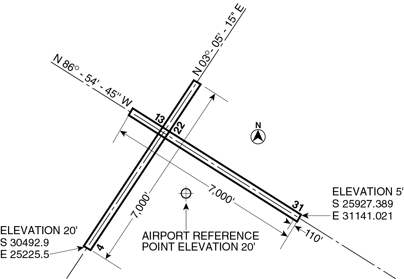
LaGUARDIA AIRPORT
Note: Coordinates shown refer to the U.S. coast and geodetic 10th Avenue base line. Elevations are above mean sea level.
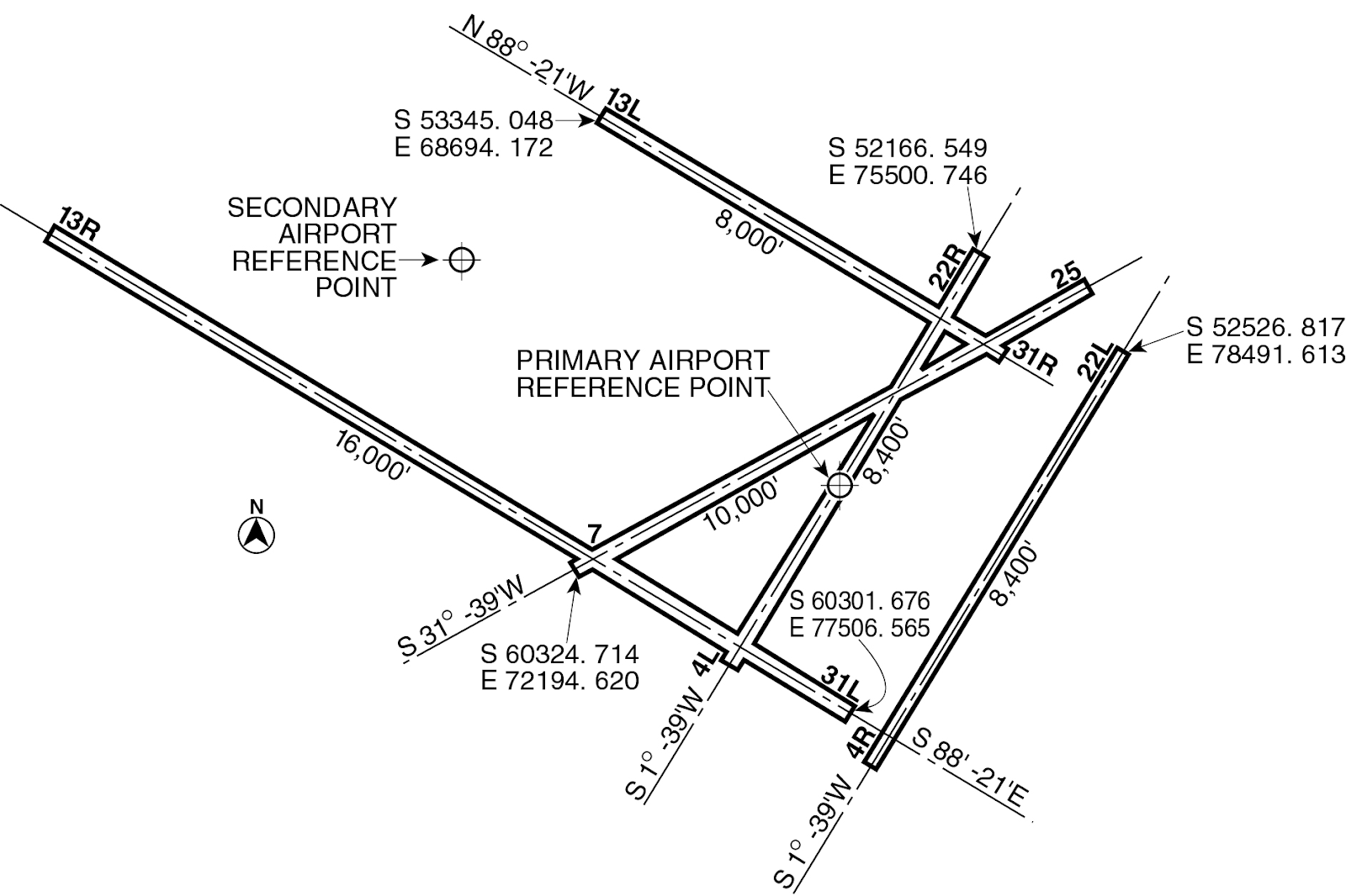
J. F. KENNEDY INTERNATIONAL AIRPORT
Note: Coordinates shown refer to the U.S. coast and geodetic 10th Avenue base line. Elevations are above mean sea level.
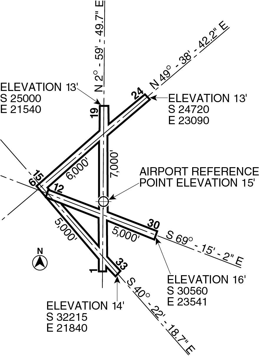
U. S. NAVAL AIR STATION
(FLOYD BENNETT FIELD)
Note: Coordinates shown refer to the U.S. coast and geodetic 10th Avenue base line. Elevations are above mean sea level.