Chapter 7 - Special Coastal Risk District (CR)
GENERAL PURPOSES
The “Special Coastal Risk District” established in this Resolution is designed to promote and protect public health, safety and general welfare in coastal areas that are currently at exceptional risk from flooding and may face greater risk in the future. These general goals include, among others, the following specific purposes:
(a) to limit the population in areas that are vulnerable to frequent flooding, including those areas exceptionally at risk from projected future tidal flooding;
(b) to reduce the potential for property damage and disruption from regular flood events and support the City’s capacity to provide infrastructure and services;
(c) to promote consistency with planned improvements, neighborhood plans, and other measures to promote drainage, coastal protection, open space and other public purposes;
(d) provide sound planning in areas that have historically been occupied by wetlands and, where plans exist, for such areas to be maintained as open space; and
(e) to promote the most desirable use of land and thus conserve the value of land and buildings, and thereby protect the City’s tax revenue.
GENERAL PROVISIONS
The provisions of this Chapter shall apply in the Special Coastal Risk District. The regulations of all other Chapters of this Resolution are applicable, except as superseded, supplemented or modified by the provisions of this Chapter. In the event of a conflict between the provisions of this Chapter and other regulations of this Resolution, the provisions of this Chapter shall control.
For transit-adjacent sites, as defined in Section 66-11 (Definitions), in the event of a conflict between the provisions of this Chapter and the provisions of Article VI, Chapter 6 (Special Regulations Applying Around Mass Transit Stations), the provisions of Article VI, Chapter 6 shall control.
In flood zones, in the event of a conflict between the provisions of this Chapter and the provisions of Article VI, Chapter 4 (Special Regulations Applying in Flood Zones), the provisions of Article VI, Chapter 4 shall control, except as specifically modified in this Chapter.
District Plan and Maps
The District Maps are located in the Appendix to this Chapter and are hereby incorporated and made part of this Resolution. They are incorporated for the purpose of specifying locations where special regulations and requirements set forth in this Chapter apply.
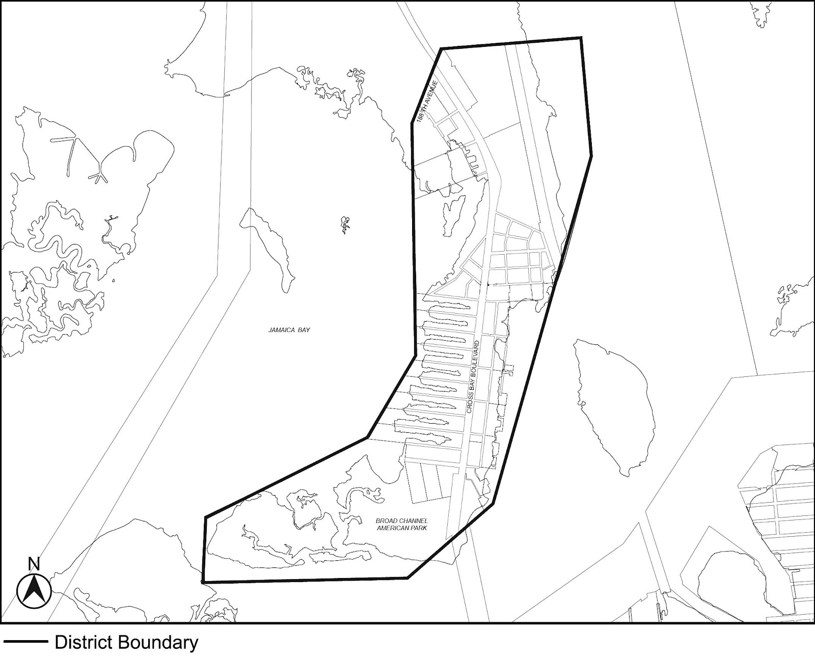
Map 1 Special Coastal Risk District 1 (CR-1), in Broad Channel, Community District 14, Borough of Queens
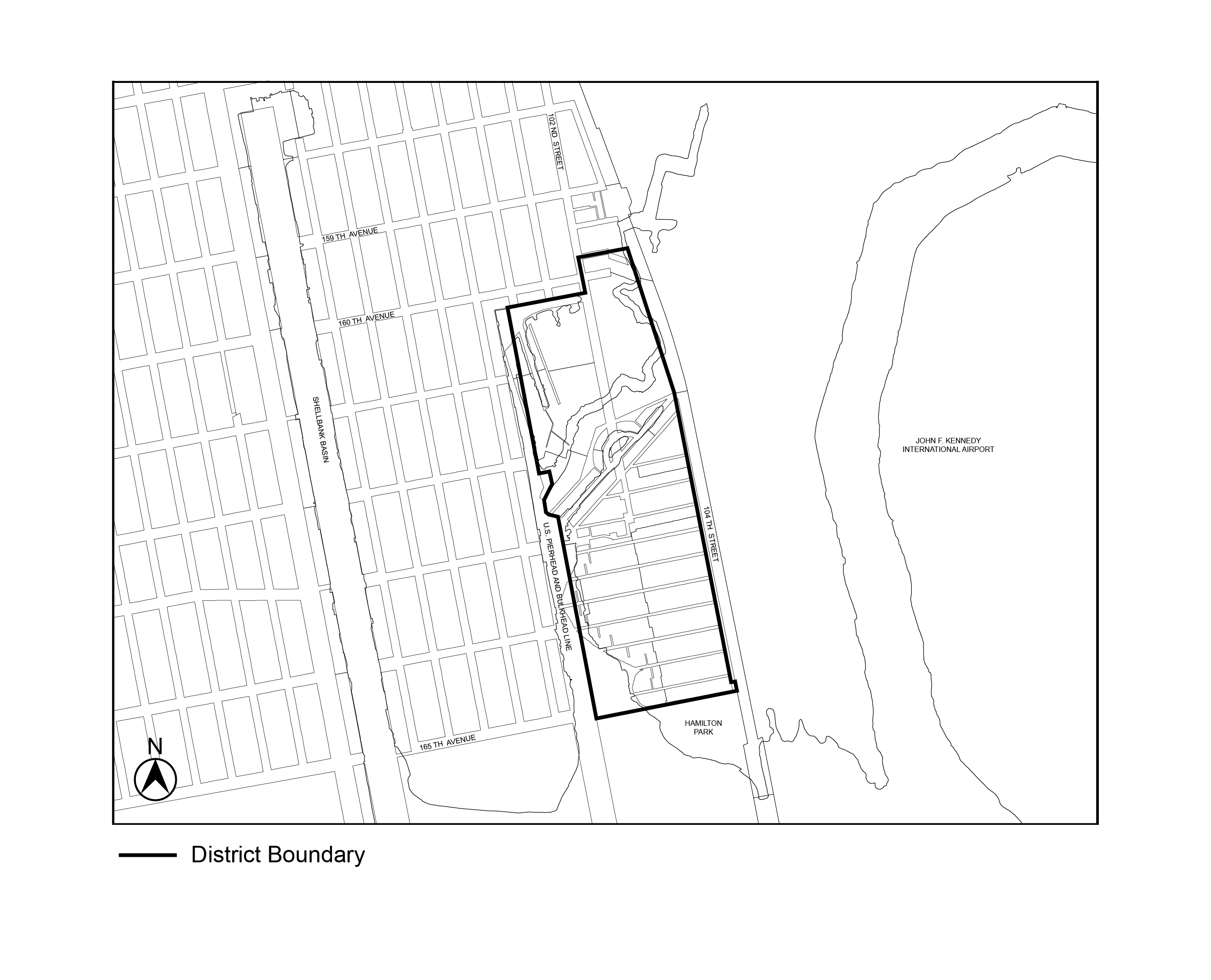
Map 2 Special Coastal Risk District 2 (CR-2), in Hamilton Beach, Community District 10, Borough of Queens
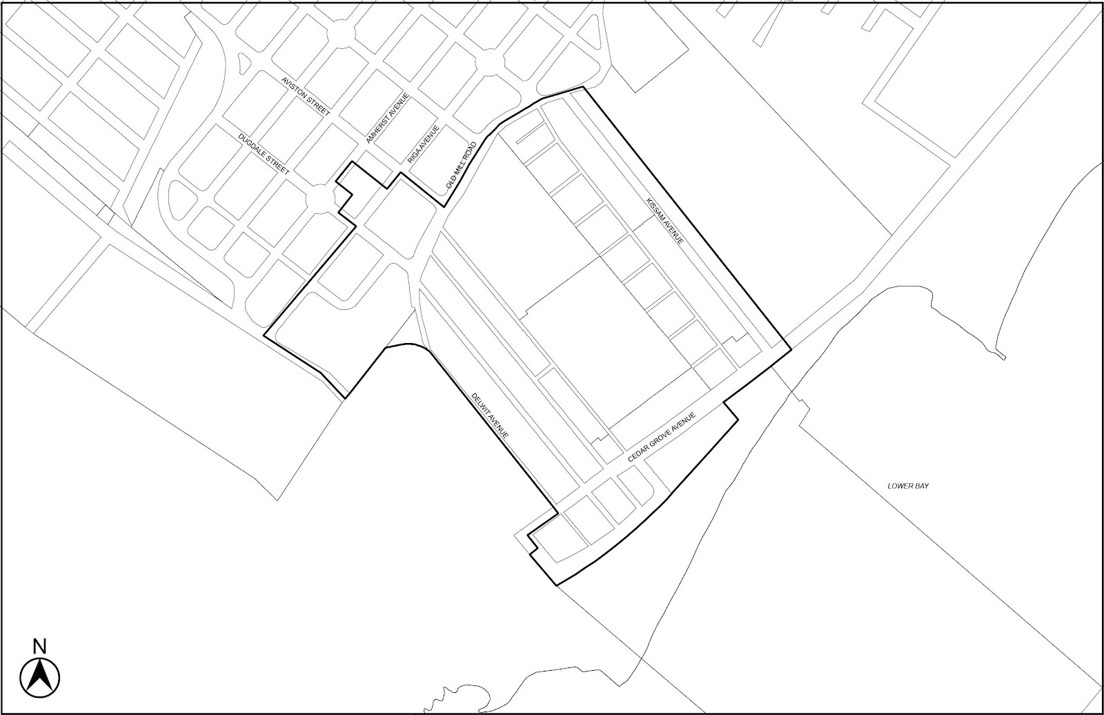
Map 3 Special Coastal Risk District 3 (CR-3), encompassing New York State Enhanced Buyout Areas in Graham Beach and Ocean Breeze, Community District 2, Borough of Staten Island
Map 4 Special Coastal Risk District 3 (CR-3), encompassing New York State Enhanced Buyout Areas in Oakwood Beach, Community District 3, Borough of Staten Island
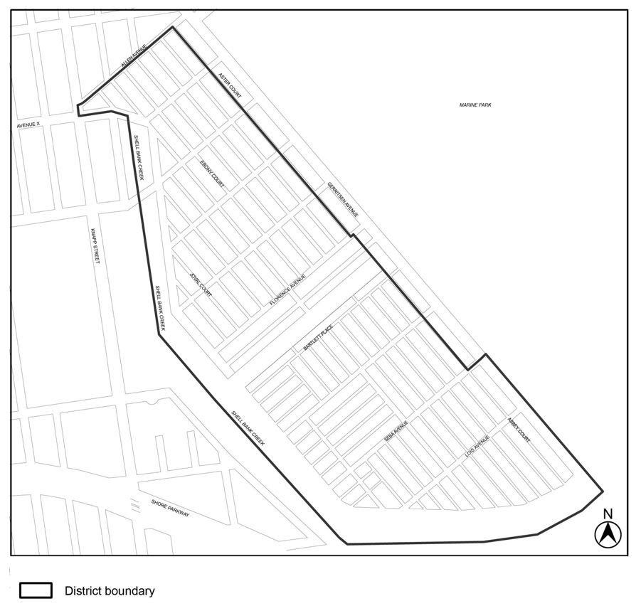
Map 5 Special Coastal Risk District 4 (CR-4), in Gerritsen Beach, Community District 15, Borough of Brooklyn
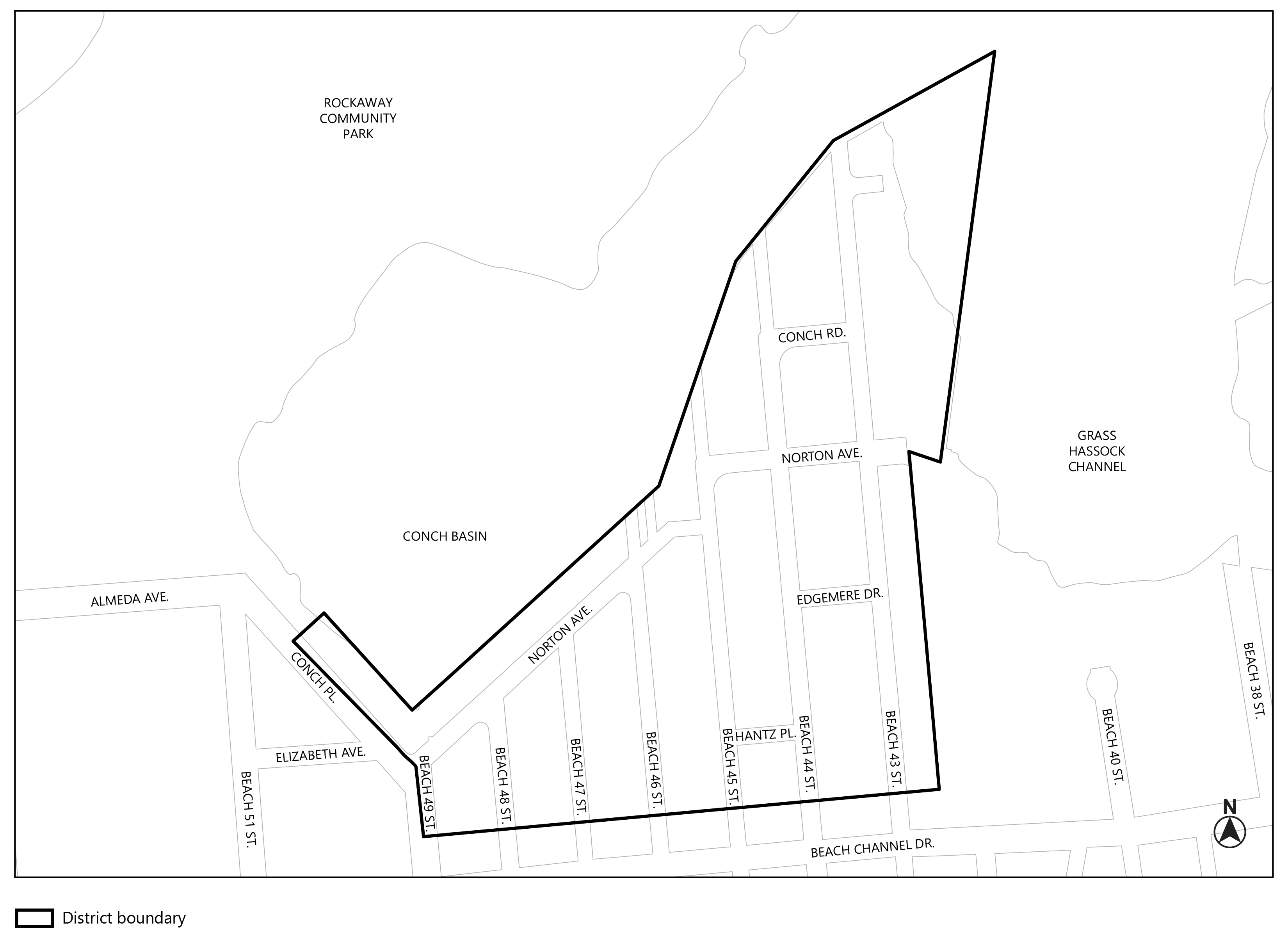
Map 6 Special Coastal Risk District 5 (CR-5), in Edgemere, Community District 14, Borough of Queens.
The special use and bulk regulations of this Chapter shall apply in the Special Coastal Risk District as set forth in the following table:
SPECIAL REGULATIONS
|
Special Coastal Risk District |
Residential Use (137-21) |
Community Facility Use (137-22) |
Modified Bulk Requirements (137-31) |
Modifications to Article V (137-40) |
Special Requirements (137-50) |
|
CR–1 (Broad Channel, Queens) |
x |
x |
|||
|
CR–2 (Hamilton Beach, Queens) |
x |
x |
x |
||
|
CR–3 (buyout areas, Staten Island) |
x |
x |
x |
x |
|
|
CR–4 (Gerritsen Beach, Brooklyn) |
x |
x |
x |
||
|
CR–5 (Edgemere, Queens) |
x |
x |
SPECIAL USE REGULATIONS
Residential Use
In Special Coastal Risk Districts, residential uses shall be permitted as follows:
- In Special Coastal Risk Districts 1 and 3, residential uses shall be limited to single-family detached residences.
- In Special Coastal Risk District 2, residential uses shall be limited to single- or two-family detached residences.
- In Special Coastal Risk District 4, residential uses shall be permitted as follows:
- for zoning lots with a lot area of less than 3,000 square feet, residential uses shall be limited to detached or semi-detached single-family residences; and
- for zoning lots with a lot area of 3,000 square feet or more, residential uses shall be limited to detached or semi-detached single- or two-family residences.
- In Special Coastal Risk District 5, residential uses shall be permitted as follows:
- in R3A and C3A Districts, residential uses shall be limited to single-family detached residences; and
- in R4-1 Districts:
- for zoning lots with a lot width of less than 25 feet, residential uses shall be limited to single-family detached residences; and
- for zoning lots with a lot width of 25 feet or more, residential uses shall be limited to single- or two-family detached residences.
- In all Special Coastal Risk Districts, there shall be no qualifying residential sites, qualifying senior housing or ancillary dwelling units.
The inclusion of accessory residential uses shall not be precluded by the provisions of this Section.
Community Facility Use
In Special Coastal Risk Districts, community facilities with sleeping accommodations shall not be permitted.
In lower density growth management areas in Special Coastal Risk District 3, the regulations for community facility uses of the underlying districts shall be modified as follows:
(a) ambulatory diagnostic or treatment health care facilities shall be limited on any zoning lot to 1,500 square feet of floor area, including cellar space; and
(b) all community facility uses shall be subject to the maximum floor area ratio, and special floor area limitations, applicable to R3-2 Districts set forth in Section 24-162 (Maximum floor area ratios and special floor area limitations for zoning lots containing residential and community facility uses in certain districts).
SPECIAL BULK REGULATIONS
Minimum Lot Width
In Special Coastal Risk District 2, the regulations of Section 23-11 (Lot Area and Lot Width in R1 Through R5 Districts) are modified such that the minimum lot width for a two-family detached residence in an R3A District shall be 40 feet.
In Special Coastal Risk District 4, all detached or semi-detached single- or two-family residences shall be subject to the height and setback provisions set forth in Section 64-332 (Height and setback regulations for cottage envelope buildings).
In Special Coastal Risk District 3, the provisions of Article V, Chapter 2 (Non-conforming Uses) shall be modified as set forth in this Section. In addition, the provisions of Article VI, Chapter 5 (Special Regulations Applying in Designated Recovery Areas) and Section 64-61 (Special Provisions for Non-conforming Uses) shall not apply.
Non-conforming uses may not be enlarged or extended. In addition, should 50 percent or more of the floor area of a building containing a non-conforming use be damaged or destroyed after September 7, 2017, the building may be repaired, incidentally altered or reconstructed only for a conforming use.
In Special Coastal Risk District 3, no development or horizontal enlargement shall occur, except where authorized by the City Planning Commission pursuant to Sections 137-51 (Authorization for Development of Single Buildings and Enlargements) or 137-52 (Authorization for Development of Multiple Buildings), as applicable. In addition, the provisions of Article VI, Chapter 5 (Special Regulations Applying in Designated Recovery Areas) and Section 64-60 (SPECIAL REGULATIONS FOR NON-CONFORMING USES AND NON-COMPLYING BUILDINGS) shall not apply.
For the purposes of determining which authorization shall be applicable, the zoning lot upon which the development shall occur shall be considered to be a tract of land that existed under separate ownership from all adjoining tracts of land on April 24, 2017.
For the purposes of such authorizations, the alteration of any existing building resulting in the removal of more than 75 percent of the floor area and more than 25 percent of the perimeter walls of such existing building, and the replacement of any amount of floor area, shall be considered a development.
The provisions of Section 137-50, inclusive, shall not apply to the reconstruction of a garage accessory to a single-family residence or two-family residence.
The provisions of Section 73-81 (Special Permit for Modification of Certain Zoning Regulations) shall be inapplicable to a building that is developed pursuant to this Section, inclusive.
The City Planning Commission may authorize a horizontal enlargement, or a development consisting of no more than one building containing a non-accessory use, on one or more zoning lots, and may modify the bulk regulations of the underlying district, except floor area ratio regulations, provided that:
(a) the site plan, to the extent practicable, minimizes the need for new paving and impervious surfaces upon the zoning lot;
(b) the site plan provides access to the new or enlarged building using streets that were improved and open to traffic on the date of application for an authorization, and which serve other occupied buildings;
(c) the site plan, to the extent practicable, minimizes adverse effects on wetlands, planned open space, drainage, or other functions in the surrounding area;
(d) the resulting building and other site improvements would not impair the essential ecological character of the surrounding area for its future use as open space;
(e) the site plan and resulting building incorporate such measures as are reasonable to minimize risks to public safety from natural hazards such as flooding and wildfires; and
(f) where the Commission is modifying bulk regulations, such modifications are the minimum necessary to protect, or provide buffering from, wetlands or wetland-adjacent areas.
The Commission may prescribe additional conditions and safeguards to minimize adverse effects on the character of the surrounding area.
The City Planning Commission may authorize a development consisting of more than one building on one or more zoning lots, and may modify the bulk regulations of the underlying district, except floor area ratio regulations, provided that:
(a) all zoning lots comprising such development together provide a minimum of 9,500 square feet of lot area per building, where no portion of such lot area shall contain delineated wetland on a wetland survey reviewed by the New York State Department of Environmental Conservation (NYSDEC). Such review by the NYSDEC shall have occurred no more than two years prior to the date of application for this authorization;
(b) the development satisfies the findings of paragraphs (a) through (e) of Section 137-51 (Authorization for Development of Single Buildings and Enlargements);
(c) where the Commission is modifying bulk regulations, such modifications shall:
(1) facilitate the configuration of buildings in order to protect, or provide buffering from, adjacent wetlands, open space and natural resources;
(2) facilitate, to the extent practicable, the configuration of buildings in proximity to the location of existing buildings within the area;
(3) limit the need for new paving and impermeable surfaces; and
(4) be consistent with the scale and character of the surrounding area.
The Commission may prescribe additional conditions and safeguards to minimize adverse effects on the character of the surrounding area.
APPENDIX
Special Coastal Risk District Plan
Map 1 - Special Coastal Risk District 1, in Broad Channel, Community District 14, Borough of Queens (6/21/17)
Map 2 - Special Coastal Risk District 2, in Hamilton Beach, Community District 10, Borough of Queens (6/21/17)
Map 3 - Special Coastal Risk District 3, encompassing New York State Enhanced Buyout Areas in Graham Beach and Ocean Breeze, Community District 2, Borough of Staten Island (9/7/17)
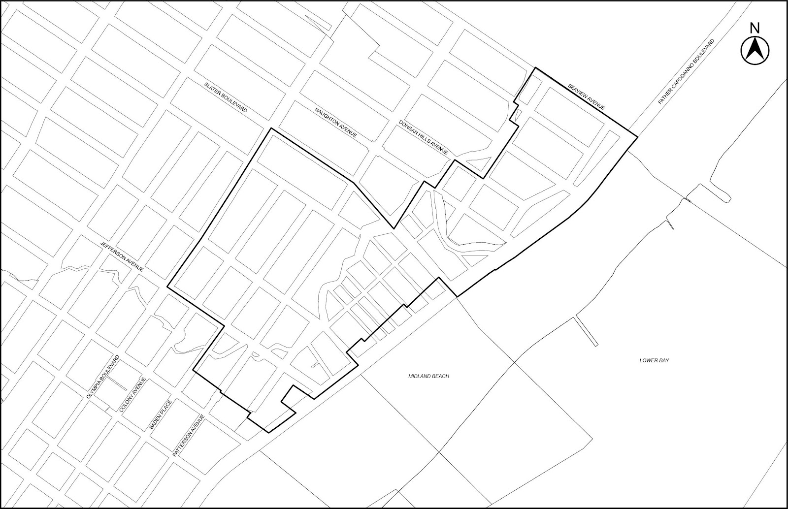
Map 4 - Special Coastal Risk District 3, encompassing New York State Enhanced Buyout Areas in Oakwood Beach, Community District 3, Borough of Staten Island (9/7/17)
Map 5 – Special Coastal Risk District 4, in Gerritsen Beach, Community District 15, Borough of Brooklyn (5/12/21)
Map 6 – Special Coastal Risk District 5, in Edgemere, Community District 14, Borough of Queens (7/14/22)