Chapter 3 - Special Southern Roosevelt Island District (SRI)
GENERAL PURPOSES
The “Special Southern Roosevelt Island District” established in this Resolution is designed to promote and protect public health, safety and general welfare. These general goals include, among others, the following specific purposes:
(a) to provide opportunities for the development of an academic and research and development campus in a manner that benefits the surrounding community;
(b) to allow for a mix of residential, retail and other commercial uses to support the academic and research and development facilities and complement the urban fabric of Roosevelt Island;
(c) to establish a network of publicly accessible open areas that take advantage of the unique location of Roosevelt Island and that integrate the academic campus into the network of open spaces on Roosevelt Island and provide a community amenity;
(d) to strengthen visual and physical connections between the eastern and western shores of Roosevelt Island by establishing publicly accessible connections through the Special District and above-grade view corridors;
(e) to encourage alternative forms of transportation by eliminating required parking and placing a maximum cap on permitted parking;
(f) to provide flexibility of architectural design within limits established to assure adequate access of light and air to the street and surrounding waterfront open areas, and thus to encourage more attractive and innovative building forms; and
(g) to promote the most desirable use of land in this area and thus conserving the value of land and buildings, and thereby protecting the City’s tax revenues.
Definitions
Definitions specifically applicable to this Chapter are set forth in this Section and may modify definitions set forth in Section 12-10 (DEFINITIONS). Where matter in italics is defined both in Section 12-10 and in this Chapter, the definitions in this Chapter shall govern.
Base plane
The definition of base plane is hereby modified to mean elevation 19.0, which elevation reflects the measurement in feet above Belmont Island Datum, which is 2.265 feet below the mean sea level at Sandy Hook, N.J.
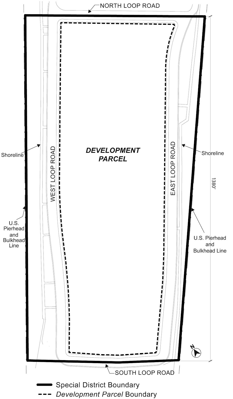
Development parcel
The “development parcel” is all of the property located within the boundaries of the Loop Road, as shown in the Appendix to this Chapter. The development parcel shall be deemed a single zoning lot for the purpose of applying all regulations of this Resolution.
Loop Road - East Loop Road, North Loop Road, South Loop Road, West Loop Road
The “Loop Road” shall be comprised of the “East Loop Road”, the “North Loop Road”, the “South Loop Road”, and the “West Loop Road”, as shown in the Appendix to this Chapter. All such roads shall be deemed separate streets for the purpose of applying all regulations of this Chapter and shall not generate floor area.
General Provisions
The provisions of this Chapter shall apply within the Special Southern Roosevelt Island District. The regulations of all other Chapters of this Resolution are applicable, except as superseded, supplemented or modified by the provisions of this Chapter. In the event of a conflict between the provisions of this Chapter and other regulations of this Resolution, the provisions of this Chapter shall control.
District Plan and Maps
The regulations of this Chapter are designed to implement the Special Southern Roosevelt Island District Plan.
The District Plan includes the following maps:
Map 1 – Special Southern Roosevelt Island District, Development Parcel and Loop Road
Map 2 – Public Access Areas.
The maps are located in Appendix A of this Chapter and are hereby incorporated and made part of this Resolution. The maps are incorporated for the purpose of specifying locations where the special regulations and requirements set forth in this Chapter apply.
The provisions of Article III, Chapter 6 (Accessory Off-Street Parking and Loading Regulations) shall not apply in the Special Southern Roosevelt Island District. In lieu thereof, a maximum of 500 accessory parking spaces shall be permitted, which may be made available for public use.
However, bicycle parking shall be provided in accordance with the provisions of Section 36-70.
The provisions of Article VI, Chapter 2 (Special Regulations Applying in the Waterfront Area), shall not apply in the Special Southern Roosevelt Island District. In lieu thereof, the area between the shoreline and the western street line of the West Loop Road and the area between the shoreline and the eastern street line of the East Loop Road shall be used exclusively for open recreational uses, and shall be accessible to the public at all times.
SPECIAL USE REGULATIONS
Additional Uses
Within the development parcel, the provisions of Section 32-10 (USE ALLOWANCES) are modified to permit listed under Use Group VII, subject to the provisions of an M1 District.
Location Within Buildings
Within the development parcel, the provisions of Section 32-422 (Location of floors occupied by commercial uses) shall not apply.
SPECIAL BULK REGULATIONS
Within the development parcel, the special bulk regulations of this Section, inclusive, shall apply.
Floor Area Ratio
The underlying floor area provisions shall apply except that:
- the provisions applicable to sky exposure plane buildings, set forth in Section 23-73 (Special Provisions for Sky Exposure Plane Buildings), inclusive, shall not apply; and
- the maximum permitted floor area ratio for laboratories listed under Use Group VII shall be 3.40.
Lot Coverage
The maximum lot coverage requirements of Section 23-36 (Maximum Lot Coverage) shall not apply. In lieu thereof, all buildings shall comply with the following aggregate lot coverage requirements:
- The maximum lot coverage from the base plane to a height that is 20 feet above the base plane shall be 70 percent.
- The maximum lot coverage from a height that is more than 20 feet above the base plane to a height that is 60 feet above the base plane shall be 60 percent.
- The maximum lot coverage from a height that is more than 60 feet above the base plane to a height that is 180 feet above the base plane shall be 45 percent.
- The maximum lot coverage above a height of 180 feet above the base plane shall be 25 percent.
The City Planning Commission may authorize an increase in the maximum lot coverage as set forth in paragraph (c) of this Section to up to 55 percent, upon finding that such increase is necessary to achieve the programmatic requirements of the development, and will not unduly restrict access of light and air to publicly accessible areas and streets.
Height and Setback
The underlying height and setback regulations shall apply, except as modified by this Section. All heights shall be measured from the base plane.
Buildings or other structures may exceed the underlying height and setback regulations for a percentage of the length of each street line of the Loop Road, as follows:
(a) North Loop Road - 65 percent
(b) East Loop Road - 35 percent
(c) West Loop Road - 35 percent
(d) South Loop Road - 65 percent.
Furthermore, the street line length percentages set forth in paragraphs (a) through (d) of this Section may be exceeded by one percentage point for every two percentage points that the lot coverage within 50 feet of a street line is less than the following percentage:
(1) North Loop Road - 50 percent
(2) East Loop Road - 30 percent
(3) South Loop Road - 50 percent
(4) West Loop Road - 30 percent.
All portions of buildings or other structures that exceed the underlying height and setback regulations in accordance with this Section shall comply with the height regulations of Section 133-232.
Height regulations
For the portion of any building or other structure exceeding the height and setback regulations set forth in Section 133-231, the maximum height of such portion located within 500 feet of the North Loop Road shall be 320 feet, exclusive of permitted obstructions allowed by the underlying height and setback regulations, and the maximum height for any such portion on the remainder of the development parcel shall be 280 feet, exclusive of such permitted obstructions.
The gross area of any story located entirely above a height of 180 feet shall not exceed 15,000 square feet. Where a single building has two or more portions located above 180 feet that are entirely separate from one another above such height, each such portion shall not exceed a gross area of 15,000 square feet for any story located in whole or part above 180 feet.
Permitted obstructions
The underlying permitted obstructions to height and setback allowances as set forth in Sections 23-41, 24-51 and 33-42 (Permitted Obstructions) shall be modified to allow energy infrastructure equipment and accessory mechanical equipment on the roof of a building, or any other structures supporting such systems, as permitted obstructions, without limitations.
Distance Between Buildings
The requirements of Section 23-371 (Distance between buildings) shall not apply, provided that if two or more buildings or portions of buildings are detached from one another at any level, such buildings, or such detached portions of buildings, shall at no point be less than eight feet apart at or below a height of 180 feet, and shall at no point be less than 60 feet apart above a height of 180 feet.
Within the Special Southern Roosevelt Island District, the City Planning Commission may, by special permit, allow a modification of the bulk regulations of this Chapter and the underlying bulk regulations, except floor area regulations, provided the Commission finds that:
(a) such modifications are necessary to achieve the programmatic requirements of the academic and research and development campus;
(b) such distribution of bulk will result in better site planning and will thus benefit both the residents, occupants or users of the Special Southern Roosevelt Island District and the surrounding neighborhood;
(c) such distribution of bulk will permit adequate access of light and air to surrounding public access areas, streets and properties; and
(d) such distribution of bulk will not unduly increase the bulk of buildings in the Special Southern Roosevelt Island District to the detriment of the occupants or users of buildings in the Special District or on nearby blocks.
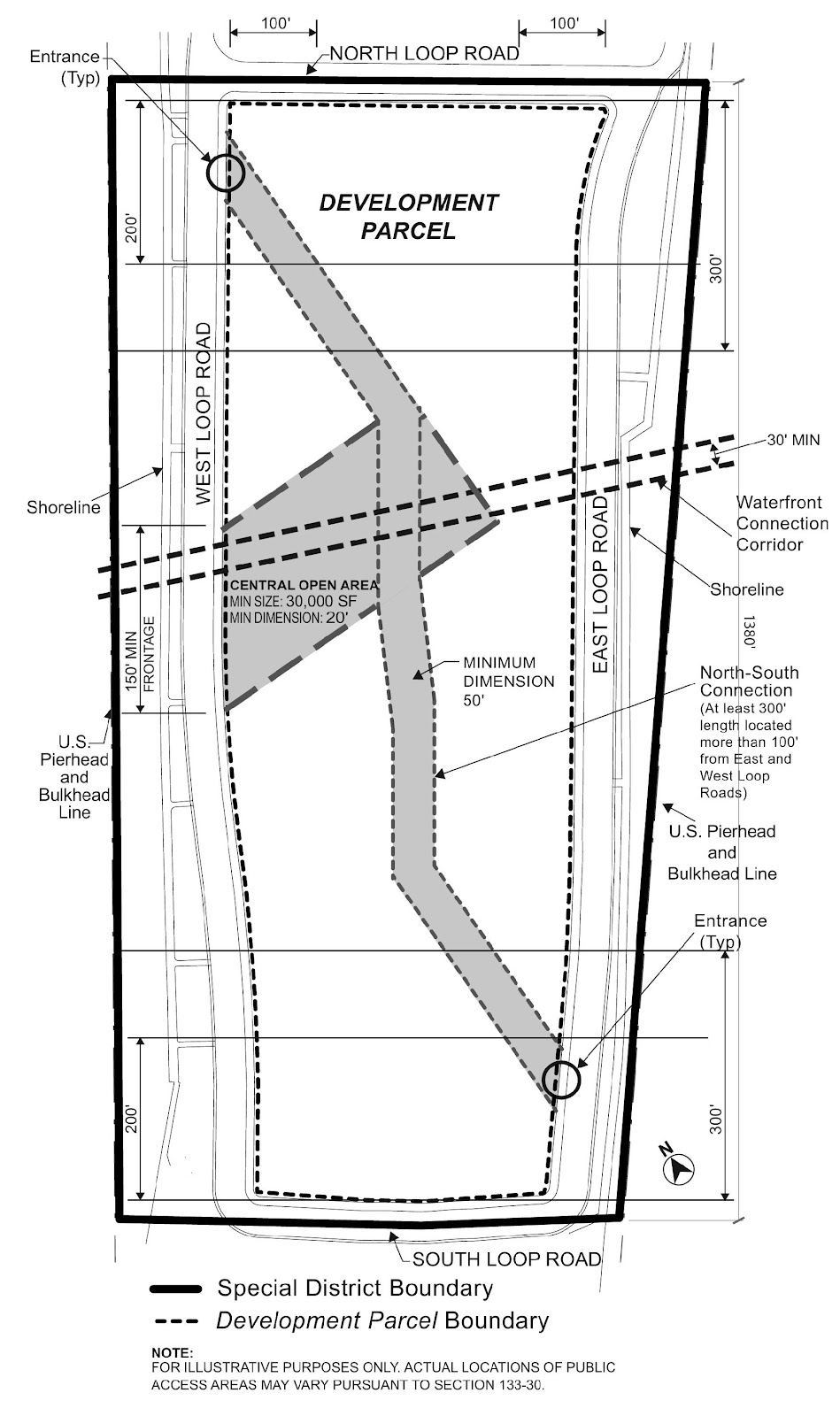
PUBLIC ACCESS AREAS
At least 20 percent of the lot area of the development parcel shall be publicly accessible and shall include, but need not be limited to, a Central Open Area, a North-South Connection, and a Waterfront Connection Corridor, for which the size and location requirements are set forth in Section 133-31. Any supplemental public access areas provided in order to meet the minimum public access lot area requirements of this Section shall comply with the requirements of paragraph (d) of Section 133-31. Design and operational standards for such public access areas are set forth in Section 133-32.
(a) Central Open Area
A Central Open Area shall front upon the West Loop Road for a minimum linear distance of 150 feet and be located at least 300 feet south of the North Loop Road, and at least 300 feet north of the South Loop Road. The Central Open Area shall be at least 30,000 square feet in area, with no portion having a dimension less than 20 feet in all directions counting toward such minimum area.
(b) North-South Connection
A continuous pedestrian connection shall be provided through the development parcel from the North Loop Road, or from the West Loop Road or East Loop Road within 200 feet of the North Loop Road, to the South Loop Road, or to the West Loop Road or East Loop Road within 200 feet of the South Loop Road. Such North-South Connection shall have a minimum width of 50 feet throughout its required length. The North-South Connection shall include at least one segment with a minimum length of 300 feet located more than 100 feet from both the West Loop Road and East Loop Road.
The North-South Connection shall connect to the Central Open Area either directly, or through a supplemental public access area having a minimum width of 30 feet. In the event that the North-South Connection traverses the Central Open Area, the area within the North-South Connection, as determined by its length and minimum required width, shall not be included in the 30,000 square foot minimum area of the Central Open Area.
There shall be at least one publicly accessible connection from the East Loop Road and from the West Loop Road to the North-South Connection. Such connections shall have a minimum width of 30 feet, and shall be located a minimum of 300 feet south of the North Loop Road and a minimum of 300 feet north of the South Loop Road. In addition, such connections may be coterminous with the Waterfront Connection Corridor required by paragraph (c) of this Section.
(c) Waterfront Connection Corridor
A Waterfront Connection Corridor shall be provided through the development parcel allowing for pedestrian access between the western boundary of the East Loop Road and either the eastern boundary of the West Loop Road or the eastern boundary of the Central Open Area. Such corridor shall be located in its entirety in the area located 300 feet south of the North Loop Road and 300 feet north of the South Loop Road. The Waterfront Connection Corridor shall have a minimum width of 30 feet.
(d) Supplemental Public Access
Supplemental public access areas may be located anywhere within the development parcel, provided such areas have a minimum dimension of 20 feet in all directions and connect directly to one or more of the Loop Roads, the North-South Connection, the Central Open Space and the Waterfront Connection Corridor.
(a) Level of public access areas and limits on coverage
At least 80 percent of publicly accessible areas shall be located at grade level, or within five feet of grade level, as such grade level may change over the development parcel, and shall be open to the sky. The remainder of such publicly accessible areas may be enclosed, covered by a structure, or located more than five feet above or below grade level, provided that such publicly accessible areas are directly accessible from public access areas that are at grade level or within five feet of grade level, and in all cases have a minimum clear height of 15 feet.
At least 50 percent of the linear street frontage for the Central Open Area required under Section 133-31, paragraph (a), shall be located at the same elevation as the adjoining sidewalk of the West Loop Road. At least 80 percent of the area of the Central Open Area shall be open to the sky, and the remainder may be open to the sky or covered by a building or other structure. A minimum clear height of 30 feet shall be provided in any area of the Central Open Area covered by a building or other structure.
The northern and southern access points to the North-South Connection shall be located at the same elevation as the adjoining public sidewalk. The elevation of the North-South Connection may vary over the remainder of its length. At least 70 percent of the area of the North-South Connection shall be open to the sky, and the remainder may be open to the sky or covered by a building or other structure. A minimum clear height of 15 feet shall be provided in any area of the North-South Connection covered by a building or other structure.
Any portion of the Waterfront Connection Corridor that is covered by a building or located within a building shall have a minimum clear height of 30 feet, provided that overhead walkways, structures and lighting occupying in the aggregate no more than 10 percent of the area of the Waterfront Connection Corridor, as determined by the minimum required width, shall be permitted within the required clear height.
(b) Clear paths
The North-South Connection and the Waterfront Connection Corridor shall each have a clear path of 12 feet throughout their entire required lengths, including those connections required between the North-South Connection and the East and West Loop Roads. All such clear paths shall be accessible to persons with disabilities.
(c) Permitted obstructions
Permitted obstructions allowed under paragraph (a) of Section 62-611 may be located within any required public access area, provided that no such permitted obstructions shall be located within a required clear path. Furthermore, kiosks may be up to 500 square feet in area, and open air cafes may occupy not more than five percent of any required public access area.
(d) Seating
A minimum of one linear foot of seating shall be provided for each 200 square feet of required public access areas. Required seating types may be moveable seating, fixed individual seats, fixed benches with or without backs, and design-feature seating such as seat walls, planter edges or steps. All required seating shall comply with the following standards:
(1) Seating shall have a minimum depth of 18 inches. Seating with 36 inches or more in depth may count towards two seats, provided there is access to both sides. When required seating is provided on a planter ledge, such ledge must have a minimum depth of 22 inches.
(2) Seating shall have a height not less than 16 inches or greater than 20 inches above the level of the adjacent walking surface. However, as described in paragraph (d)(5) of this Section, seating steps may have a height not to exceed 30 inches and seating walls may have a height not to exceed 24 inches.
(3) At least 50 percent of the linear feet of fixed seating shall have backs at least 14 inches high and a maximum seat depth of 20 inches. Walls located adjacent to a seating surface shall not count as seat backs. All seat backs must either be contoured in form for comfort or shall be reclined from vertical between 10 to 15 degrees.
(4) Moveable seating shall be credited as 24 inches of linear seating per chair. All moveable seats must have backs and a maximum seat depth of 20 inches. Moveable chairs shall not be chained, fixed, or otherwise secured while the public access area is open to the public.
(5) Seating steps and seating walls may be used for required seating if such seating does not, in aggregate, represent more than 15 percent of the linear feet of all required seating. Seating steps shall not include any steps intended for circulation and must have a height not less than six inches nor greater than 30 inches and a depth not less than 18 inches. Seating walls shall have a height not greater than 18 inches; such seating walls, however, may have a height not to exceed 24 inches if they are located within 10 feet of an edge of a public access area.
Seating shall be provided in the Central Open Area in an amount equal to a minimum of one linear foot for every 100 square feet of the Central Open Area. Such seating shall include at least one moveable chair for every 500 square feet of the Central Open Area, and at least one other seating type. One table shall be provided for every four moveable chairs. At least 15 percent of the required seating shall be located within 20 feet of any Loop Road, and at least 10 percent of such required seating shall be located within 20 feet of the North-South Connection or any supplemental public access area that connects the Central Open Area to the North-South Connection.
Seating shall be provided in the North-South Connection in an amount equal to at least one linear foot for every 150 square feet of the North-South Connection. At least 20 linear feet of such seating shall be located within 20 feet of its northern entrance and an additional 20 linear feet of such seating shall be located within 20 feet of its southern entrance. There shall be at least two types of seating in the North-South Connection.
Seating for open air cafes may be used by members of the public regardless of whether such persons are patrons of a cafe when not being used for service.
(e) Planting
At least 20 percent of the required public access areas on the development parcel shall be comprised of planted areas, including planting beds and lawns.
At least 30 percent of the Central Open Area shall be planted with lawns, planting beds or a combination thereof.
(f) Hours
All required public access areas shall be open daily from 6:00 a.m. to 10:00 p.m. Signs stating that the North-South Connection is publicly accessible shall be posted at its northern and southern entrances. Signs indicating that the Central Open Space is publicly accessible shall be posted at its entrance from the West Loop Road and the North-South Connection.
BUILDING PERMITS
The Department of Buildings shall not approve any application for a building permit for a development or enlargement unless such application shows the location of the Central Open Area, the North-South Connection and the Waterfront Connection Corridor, and any supplemental public access areas, for the purpose of demonstrating that the required amount of public access area, as set forth in Sections 133-30 and 133-31, is able to be accommodated on the development parcel.
PHASING
The public access areas required pursuant to Section 133-30, inclusive, may be built out in phases on the development parcel in accordance with this Section.
No temporary or permanent certificate of occupancy from the Department of Buildings may be issued for more than 300,000 square feet of floor area developed or enlarged on the development parcel until the Chairperson of the City Planning Commission certifies to the Commissioner of Buildings that at least 25,000 square feet of public access area is substantially complete and open to the public.
No temporary or permanent certificate of occupancy from the Department of Buildings may be issued for more than 500,000 square feet of floor area developed or enlarged on the development parcel until the Chairperson of the City Planning Commission certifies to the Commissioner of Buildings that at least 40,000 square feet of public access area is substantially complete and open to the public. The Central Open Area shall be part of the public access area required to be substantially completed and open to the public under this paragraph.
No temporary or permanent certificate of occupancy from the Department of Buildings may be issued for each additional 200,000 square feet of floor area developed or enlarged on the development parcel until the Chairperson of the City Planning Commission certifies to the Commissioner of Buildings that an additional 12,000 square feet of public access area is substantially completed and open to the public. A portion of the North-South Connection connecting at least one of the Loop Roads and the Central Open Area shall be substantially completed and open to the public prior to obtaining a temporary or permanent certificate of occupancy for more than 750,000 square feet of floor area developed or enlarged on the development parcel. The Waterfront Connection shall be substantially completed and open to the public prior to obtaining a temporary or permanent certificate of occupancy for more than 900,000 square feet of floor area developed or enlarged on the development parcel.
Except as set forth above, the open space provided pursuant to this Section may include interim open space areas, provided that no temporary or permanent certificate of occupancy from the Department of Buildings may be issued for more than 1,700,000 square feet of floor area developed or enlarged on the development parcel until the Chairperson of the City Planning Commission certifies to the Commissioner of Buildings that all of the Central Open Area, the North-South Connection and the Waterfront Connection are substantially complete and open to the public.
Not more than 20 percent of the lot area of the development parcel shall be required to be improved as public access areas, and the obligation to provide public access areas, in accordance with paragraphs (a), (b), (c) and (d) of this Section, shall terminate at such time as 20 percent of the lot area of the development parcel has been improved as public access areas and has been opened to the public.
Any public access area may be modified, eliminated or reconfigured over time, provided that such modification, elimination or reconfiguration does not reduce the amount of public access area required under Section 133-60 (PHASING) for the amount of floor area located on the development parcel at the time of such activity. Any modified or reconfigured public access area shall comply with the applicable provisions of Section 133-30, inclusive.
NO-BUILD VOLUME
A volume shall be established on the development parcel between a line that is 300 feet south of the North Loop Road and a line that is 300 feet north of the South Loop Road. Such volume shall extend from the East Loop Road to the West Loop Road along a line that is within 30 degrees of the line connecting true east and true west. The minimum width of such volume shall be 50 feet, with its lowest level 60 feet above the base plane. Such volume shall be open to the sky. No obstructions of any kind shall be permitted within such volume.