Chapter 2 - Special Inwood District (IN)
GENERAL PURPOSES
The “Special Inwood District” established in this Resolution is designed to promote and protect public health, safety and general welfare. These general goals include, among others, the following specific purposes:
(a) to create a lively and attractive built environment that will provide amenities and services for the use and enjoyment of area residents, workers and visitors;
(b) to encourage well-designed development that complements and enhances the built character of the neighborhood;
(c) to enhance neighborhood economic diversity by broadening the range of housing choices for residents of varied incomes;
(d) to maintain and establish physical and visual public access to and along the waterfront;
(e) to promote the pedestrian orientation of ground floor uses in appropriate locations, and thus safeguard a traditional quality of higher density areas of the City;
(f) to take advantage of the waterfront along the Harlem River, Sherman Creek, and the North Cove and create a public open space network;
(g) to focus higher-density development in appropriate locations along wide, mixed-use corridors with good access to transit;
(h) to provide flexibility of architectural design within limits established to assure adequate access of light and air to streets and public access areas, and thus encourage more attractive and economic building forms; and
(i) to promote the most desirable use of land and development in accordance with the District Plan for the Inwood waterfront, and thus conserve and enhance the value of land and buildings, and thereby protect the City’s tax revenues.
General Provisions
The provisions of this Chapter shall apply within the Special Inwood District. The regulations of all other Chapters of this Resolution are applicable, except as superseded, supplemented or modified by the provisions of this Chapter. In the event of a conflict between the provisions of this Chapter and other regulations of this Resolution, the provisions of this Chapter shall control. However, in flood zones, or for transit-adjacent sites or qualifying transit improvement sites, as defined in Section 66-11 (Definitions), in the event of a conflict between the provisions of this Chapter and the provisions of Article VI, Chapter 4 (Special Regulations Applying in Flood Hazard Areas), or Article VI, Chapter 6 (Special Regulations Applying Around Mass Transit Stations), the provisions of Article VI shall control.
District Plan and Maps
The regulations of this Chapter are designed to implement the Special Inwood District Plan. The District Plan, including Map 1 (Special Inwood District – Subdistricts and Subareas), Map 2 (Special Inwood District – Ground Floor Use and Curb Cut Regulations), and Map 3 (Special Inwood District – Transit Easement Zones) is set forth in the Appendix to this Chapter and is hereby incorporated as part of this Resolution for the purpose of specifying locations where the special regulations and requirements set forth in this Chapter apply. In order to carry out the purposes and provisions of this Chapter, district maps are located in the Appendix to this Chapter and are hereby incorporated and made an integral part of this Resolution. They are incorporated for the purpose of specifying locations where special regulations and requirements, as set forth in the text of this Chapter, apply.
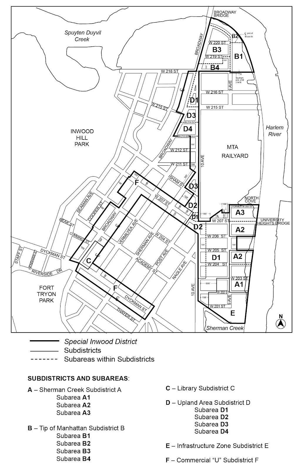
Map 1. Special Inwood District – Subdistricts and Subareas
Map 2. Special Inwood District – Ground Floor Use and Curb Cut Regulations
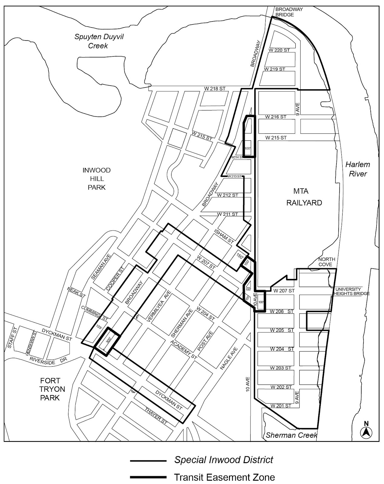
Map 3. Special Inwood District – Transit Easement Zones
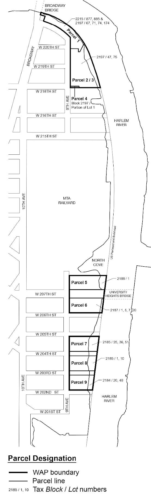
Map 4. Waterfront Access Plan: Parcel Designation
Map 5. Waterfront Access Plan: Public Access Areas
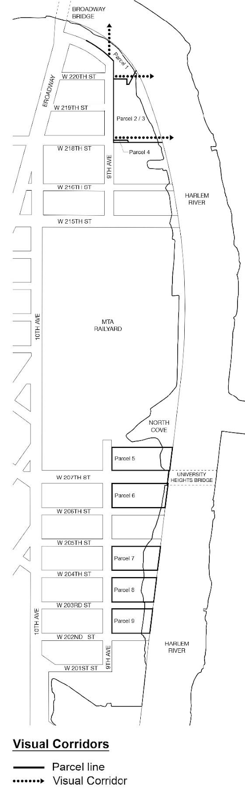
Map 6. Waterfront Access Plan: Visual Corridors
Subdistricts and Subareas
In order to carry out the provisions of this Chapter, six subdistricts are established, as follows:
Sherman Creek Subdistrict A
Tip of Manhattan Subdistrict B
Library Subdistrict C
Upland Area Subdistrict D
Infrastructure Zone Subdistrict E
Commercial “U” Subdistrict F
In each of these subdistricts, certain special regulations apply which do not apply within the remainder of the Special Inwood District. Within certain subdistricts, subareas are established, as follows:
Within Sherman Creek Subdistrict A:
Subarea A1
Subarea A2
Subarea A3
Within Tip of Manhattan Subdistrict B:
Subarea B1
Subarea B2
Subarea B3
Subarea B4
Within Upland Area Subdistrict D
Subarea D1
Subarea D2
Subarea D3
Subarea D4
The location and boundaries of subdistricts and subareas are outlined on Map 1 (Special Inwood District - Subdistricts and Subareas) in the Appendix to this Chapter.
Definitions
For purposes of this Chapter, matter in italics is defined in Section 12-10 (DEFINITIONS), Section 32-301 (Definitions) and in this Section.
Shoreline adjacent lot
For the purposes of this Chapter, a “shoreline adjacent lot” shall refer to a waterfront zoning lot with a shoreline length of more than 100 feet, or any zoning lot that has entered into a binding agreement to improve and maintain a waterfront public access area for an adjoining waterfront zoning lot.
Applicability
Mandatory Inclusionary Housing areas within the Special Inwood District are shown in APPENDIX F of this Resolution.
In M1 Districts paired with a Residence District, the special use, bulk and parking and loading provisions of Article XII, Chapter 3 (Special Mixed Use District) shall apply, except where modified by the provisions of this Chapter, and shall supplement or supersede the provisions of the designated Residence or M1 District, as applicable.
Where the lot line of a zoning lot coincides with the former boundary of West 208th Street, as shown on Map 1 in the Appendix to this Chapter, such lot line shall be considered a street line for the purpose of applying all use and bulk regulations of this Resolution.
In Subarea A1, as shown on Map 1 (Special Inwood District – Subdistricts and Subareas) in the Appendix to this Chapter, when a volume above a street, or portion thereof, has been eliminated, discontinued or closed, such volume may, at the option of an owner of a zoning lot adjoining such volume, be considered part of the adjoining zoning lot, and a development or enlargement may be located within such volume that is part of or connected to a building on the adjoining zoning lot utilizing floor area generated by the adjoining zoning lot, provided that the street below the volume is provided with lighting in accordance with Department of Transportation standards. In no event shall such volume contribute to the amount of lot area of any zoning lot for the purposes of generating floor area.
Shoreline Boundary
For the purposes of this Chapter, the shoreline shall be as shown on a survey available on the Department of City Planning website.
For all developments or enlargements involving ground floor level construction on a zoning lot that is wholly or partially located within a Transit Easement Zone, as shown on Map 3 (Special Inwood District – Transit Easement Zones) in the Appendix to this Chapter, a transit easement volume may be needed on such zoning lot for public access between the street and the adjacent above- or below-grade subway station, pursuant to the provisions of Section 66-20 (SPECIAL PROVISIONS FOR PRIMARY TRANSIT-ADJACENT SITES). Such zoning lots that are wholly or partially within a Transit Easement Zone shall be considered a primary transit-adjacent site, as defined in Section 66-11 (Definitions).
SPECIAL USE REGULATIONS
The underlying use regulations are modified by the provisions of this Section, inclusive. In M1-4/R7A and M1-4/R9A Districts, the use regulations of Article XII, Chapter 3 (Special Mixed Use District) shall apply, except where modified by the provisions of this Section, inclusive.
Permitted Uses
In Subarea B1, as shown on Map 1 (Special Inwood District – Subdistricts and Subareas) in the Appendix to this Chapter, commercial or public utility vehicle storage, open or enclosed, including accessory motor fuel pumps, listed under Use Group IX(C), shall be a permitted use, open or enclosed.
In Subareas B2 and B3, as shown on Map 1, uses listed under Use Group III, shall be permitted, and uses listed under Food and Beverage Retailers in Use Group VI shall not be limited to floor area per establishment.
In Subdistrict D, as shown on Map 1, self-service storage facilities listed under Use Group IX(A), shall be permitted as-of-right in C6-2A Districts.
In Subareas B2 and B3, as shown on Map 1 (Special Inwood District – Subdistricts and Subareas) in the Appendix to this Chapter, the manufacturing uses permitted in M1 Districts shall be subject to the modifications set forth in Section 123-20 (SPECIAL USE REGULATIONS), inclusive.
Location of Uses
In C2 Districts mapped within R7 or R8 Districts, provisions of Section 32-421 (Limitation on floors occupied by commercial uses) shall be modified or buildings containing residences as follows. The limitations set forth in paragraph (a) of such Section shall be modified to apply to buildings constructed before August 8, 2018.
Within the portion of the C2-4 District mapped within an R8A District and the portion of the C2-4 District mapped within an R9A District, located east of Tenth Avenue, south of West 207th Street, west of Ninth Avenue and north of West 206th Street, the underlying provisions of Section 32-421 (Limitation on floors occupied by commercial uses) shall be inapplicable. In lieu thereof, Section 32-422 (Location of floors occupied by commercial uses) shall apply.
In C4 or C6 Districts, the provisions of Section 32-422 (Location of floors occupied by commercial uses) shall be modified such that the limitations set forth in paragraph (a) of such Section need not apply, and the requirements in paragraph (b) of such Section shall apply only where commercial uses are located above any story containing dwelling units.
In Subareas A1, B2 and B3, as shown on Map 1 (Special Inwood District – Subdistricts and Subareas) in the Appendix to this Chapter, no uses listed under Use Group VI shall be permitted above the ground floor level.
Streetscape Requirements
The underlying ground floor level streetscape provisions set forth in Section 32-30 (STREETSCAPE REGULATIONS), inclusive, shall apply, except that ground floor level street frontages along streets, or portions thereof, designated on Map 2 (Special Inwood District – Ground Floor Use and Curb Cut Regulations) in Appendix A of this Chapter shall be considered Tier C street frontages.
The underlying floor area regulations are modified by the provisions of this Section, inclusive.
On waterfront blocks, the provisions of Section 62-31 (Bulk Computations on Waterfront Zoning Lots) shall be modified so that lot area that is seaward of the shoreline shall not be included for the purpose of determining allowable floor area or to satisfy any other bulk regulation.
In Subareas A2, A3 and B1, as shown on Map 1 (Special Inwood District – Subdistricts and Subareas) in the Appendix to this Chapter, the floor area regulations shall be modified as follows:
For zoning lots other than shoreline adjacent lots the maximum residential floor area ratio shall be 4.6. For shoreline adjacent lots, the maximum residential floor area ratio for qualifying affordable housing or qualifying senior housing shall be as set forth in Section 23-22 (Floor Area Regulations for R6 Through R12 Districts) for the particular district.
For zoning lots that are divided by zoning district boundary lines, floor area may be distributed within a zoning lot without regard to zoning district boundary lines.
Accessory parking located below a height of 33 feet shall be exempt from the definition of floor area.
In Subarea B2, as shown on Map 1 (Special Inwood District – Subdistricts and Subareas) in the Appendix to this Chapter, all permitted uses shall have a permitted floor area ratio of 2.0. In Subarea B3, as shown on Map 1, the base floor area ratio shall be 5.0, and may be increased only in accordance with the provisions of this Section.
The Chairperson of the City Planning Commission shall allow, by certification, a transfer of floor area from a zoning lot located in Subarea B2 to a zoning lot located in Subarea B3 provided that the provisions of this Section are met. For the purpose of this Section, a “granting lot” shall mean a zoning lot within Subarea B2 that transfers floor area pursuant to this Section, and a “receiving lot” shall mean a zoning lot within Subarea B3 that receives additional floor area pursuant to this Section.
Such certification for a transfer of floor area shall be subject to the following conditions:
(a) the maximum amount of floor area that may be transferred from a granting lot shall be based on a floor area ratio of 2.0, less the total floor area of all existing buildings on the granting lot and any previously transferred floor area;
(b) each transfer, once completed, shall irrevocably reduce the amount of floor area that may be developed or enlarged on the granting lot by the amount of floor area transferred;
(c) for developments or enlargements, which in the aggregate for both the granting lot and the receiving lot, involve an increase in the floor area of more than 20,000 square feet of the amount existing on August 8, 2018, a waterfront certification pursuant to Section 62-811 (Waterfront public access and visual corridors) has been granted; and
(d) prior to the issuance of a building permit, as set forth in this Section, the owners of the granting lot and the receiving lot shall submit to the Chairperson a copy of the transfer instrument legally sufficient in both form and content to effect such a transfer. Notice of the restrictions upon further development or enlargement of the granting lot and the receiving lot shall be filed by the owners of the respective lots in the Office of the Register of the City of New York (County of New York). Proof of recordation shall be submitted to the Chairperson.
Both the transfer instrument and the notices of restrictions shall specify the total amount of floor area transferred and shall specify, by block and lot numbers, the granting lot and the receiving lot that are a party to such transfer.
An application filed with the Chairperson for certification pursuant to this Section shall be made jointly by the owners of the granting lot and the receiving lot, and shall include site plans and zoning calculations for the granting lot and receiving lot showing the additional floor area associated with the transfer, and any such other information as may be required by the Chairperson.
The Chairperson shall certify to the Department of Buildings that a development or enlargement is in compliance with the provisions of this Section only after the transfer instrument and notice of restrictions required by this Section have been executed and recorded with proof of recordation provided to the Chairperson. Such certification shall be a precondition to the filing for or issuing of any building permit allowing more than the basic maximum floor area ratio for such development.
A separate application shall be filed for each transfer of floor area to any zoning lot pursuant to this Section.
For zoning lots that are located partially in a Commercial District mapped within an R8A District and partially in a Commercial District mapped within an R9A District, residential floor area may transfer across the zoning district boundary from the Commercial District mapped within an R8A District to the Commercial District mapped within an R9A District.
SPECIAL YARD REGULATIONS
The underlying yard regulations are modified by the provisions of this Section.
In M1-4/R7A and M1-4/R9A Districts, in Subareas A1 and B3 as shown on Map 1 (Special Inwood District – Subdistricts and Subareas) in the Appendix to this Chapter, and in the portion of the C2-4 District mapped within an R8A District or the portion of the C2-4 District mapped within an R9A District, located east of Tenth Avenue, south of West 207th Street, west of Ninth Avenue, and north of West 206th Street, no rear yard equivalents are required for through lots or through lot portions of a zoning lot.
In Subdistrict D, no rear yard is required along any portion of a rear lot line that is coincident with a lot line of the rail yard for the Metropolitan Transportation Authority located east of Tenth Avenue between West 207th Street and West 215th Street.
A waterfront yard, as defined in Section 62-11 (Definitions), shall be provided on any portion of a zoning lot located within 40 feet of the shoreline. Any other yard regulations shall be inapplicable within such portion of a zoning lot.
In Subareas A1 and B2, and in Subdistrict E, as shown on Map 1 (Special Inwood District – Subdistricts and Subareas) in the Appendix to this Chapter, the height and setback regulations of the underlying districts shall apply.
In Subareas A2, A3, B1, B3 and B4, the height and setback regulations of the underlying district regulations are modified by Sections 142-41 through 142-47 shall apply, and all heights shall be measured from the base plane.
In Subdistricts C, D and F, the height and setback regulations of the underlying district regulations are modified by Sections 142-48 (Special Regulations for Certain Sites in Subdistricts C and F) and 142-49 (Height and Setback for Certain Zoning Lots in Subdistricts C and D), as applicable.
In Subareas A2, A3, B1, B3 and B4, as shown on Map 1 (Special Inwood District – Subdistricts and Subareas) in the Appendix to this Chapter, the provisions of Section 33-42 (Permitted Obstructions) shall apply to all buildings. In addition, a dormer shall be allowed as a permitted obstruction pursuant to paragraph (b) of Section 23-413 (Permitted obstructions in certain districts), and balconies shall be permitted in conjunction with residential uses as set forth in Section 23-62 (Balconies).
In Subareas A2, A3 and B1, as shown on Map 1 (Special Inwood District – Subdistricts and Subareas) in the Appendix to this Chapter, for zoning lots other than shoreline adjacent lots, the height and setback regulations for R7A Districts set forth in the applicable provisions of Section 23-43, inclusive, shall apply.
The street wall location provisions of paragraph (a) of Section 35-631 shall apply to street frontages along and within 50 feet of Ninth Avenue, and the street wall requirements of paragraph (b) of Section 35-631 shall apply along all other street frontages of the zoning lot.
In Subarea A2, as shown on Map 1 (Special Inwood District – Subdistricts and Subareas) in the Appendix to this Chapter, for shoreline adjacent lots, the following height and setback regulations shall apply:
- Street wall location
The street wall location provisions of paragraph (a) of Section 35-631 shall apply to street frontages along and within 50 feet of Ninth Avenue, and the street wall requirements of paragraph (b) of Section 35-651 shall apply along all other street frontages of the zoning lot. However, the street walls shall extend to at least the minimum base height set forth in paragraph (b) of this Section, or the height of the building, whichever is less. - Base height and setbacks
The minimum base height shall be 60 feet on all street frontages. Within R9A Districts, or C1 or C2 Districts mapped within R9A Districts, the maximum base height shall be 105 feet. Within R8 Districts, or C1 or C2 Districts mapped within R8 Districts, the maximum base height before setback shall be 105 feet if the building’s maximum overall height does not exceed 155 feet, or 85 feet if a building is developed with a tower in accordance with the regulations of paragraph (e) of this Section.
At a height not lower than the minimum base height nor higher than the maximum base height specified for the applicable district, a setback with a minimum depth of 10 feet shall be provided from the street wall of the base. Such setbacks may be modified in accordance with the provisions of Section 23-433. - Within 50 feet of the shoreline
Within 50 feet of the shoreline, the height of a building along 30 percent of the length of a zoning lot, as measured parallel to Ninth Avenue, shall be limited to a maximum height of 30 feet, and the height along the remaining 70 percent may rise to a maximum height of 85 feet. - Maximum transition height
After the required setback, buildings may rise to a maximum transition height of 155 feet. However, for portions of buildings exceeding the maximum base height with a gross area of a story of 10,000 square feet, or more, exclusive of any permitted dormers, setbacks shall be taken at any point above 125 feet to achieve a footprint reduction of 10 percent from stories below 125 feet. Any portion of a building that exceeds the maximum transition height shall be considered a tower and subject to the provisions of paragraph (e) of this Section. - Tower regulations
Any portion of a building that exceeds the maximum transition height shall be subject to the following tower provisions:- the gross area of any story shall not exceed 10,000 square feet, except that any dormers provided within the setback area shall not be included in such gross area;
- the gross area of any story located above 205 feet shall not exceed 90 percent of the gross area of that story located directly below a height of 205 feet;
- no portion of such tower shall be located within 80 feet of the shoreline;
- the width of such tower shall not exceed 100 feet, as measured parallel to Ninth Avenue. Such width shall be measured in plan and shall include the total width of the combined lot coverage of all stories above 125 feet; and
- the maximum height of such tower shall not exceed 245 feet.
Zoning lots with a lot area in excess of 1.5 acres may contain a second tower, provided that the heights of the two towers differ by at least 50 feet from each other, and provided that the combined width of the towers does not exceed 140 feet, as measured parallel to Ninth Avenue. Such width shall be measured in plan and shall include the total width of the combined lot coverage of all stories above 125 feet.
In Subarea A3, as shown on Map 1 (Special Inwood District – Subdistricts and Subareas) in the Appendix to this Chapter, for shoreline adjacent lots, the height and setback regulations of this Section shall apply:
- Base along West 207th Street and Ninth Avenue
Along the West 207th Street and Ninth Avenue frontages, the street wall location provisions of paragraph (b) of Section 35-631 shall apply except that the street wall shall extend up to a minimum base height of 60 feet, or the height of the building, whichever is less, and a maximum base height of 105 feet. The boundary of any easement required for a street or sidewalk widening pursuant to Section 142-64 shall be considered the street line for the purpose of this Section.
At a height not lower than the minimum base height nor higher than the maximum base height, a setback with a minimum depth of 10 feet shall be provided from the street wall of the base. Such setbacks may be modified in accordance with the provisions of Section 23-433. - Within 50 feet of the shoreline
Within 50 feet of the shoreline, the maximum building height shall be 85 feet. - Within 30 feet of former West 208th Street
Within 30 feet of Former West 208th Street, as shown on Map 1 in the Appendix to this Chapter, the height of a building along 30 percent of the length of a zoning lot, as measured along the former extent of West 208th Street, shall not exceed 30 feet, and the height of the remaining 70 percent may rise to a maximum height of 85 feet. - Maximum transition height
Within the portion of the zoning lot that is beyond 100 feet of West 207th Street, after the required setback, buildings may rise to a maximum transition height of 145 feet. No towers shall be permitted above such maximum transition height.
Within the portion of the zoning lot that is within 100 feet of West 207th Street, after the required setback, buildings may rise to a maximum transition height of 175 feet. Any portion of a building that exceeds such maximum transition height shall be considered a tower and subject to the provisions of paragraph (e) of this Section. - Tower regulations
Any portion of a building that exceeds the maximum transition height shall be subject to the following tower provisions:- the gross area of any story shall not exceed 10,000 square feet, except that any dormers provided within the setback area shall not be included in such gross area;
- the gross area of any story located above 255 feet shall not exceed 90 percent of the gross area of that story located directly below a height of 255 feet; and
- the maximum height of such tower shall not exceed 295 feet.
In Subarea B1, as shown on Map 1 (Special Inwood District – Subdistricts and Subareas) in the Appendix to this Chapter, for shoreline adjacent lots, the height and setback regulations of Section 142-43 (Height and Setback for Sites in Subarea A2 With More Than 100 Feet of Shoreline) shall apply, except that paragraph (e) of such Section shall be modified to allow a tower to rise to a height of 265 feet, provided that the gross area of any story above 225 feet does not exceed 90 percent of the gross area of that story located directly below 225 feet. The visual corridor located between a line parallel to and 20 feet south of the prolongation of the centerline of West 218th Street and a line parallel to and 30 feet north of such centerline established by Section 142-60 (INWOOD WATERFRONT ACCESS PLAN) shall be treated as a narrow street line for the purposes of applying all height and setback regulations.
In Subarea B3, as shown on Map 1 (Special Inwood District – Subdistricts and Subareas) in the Appendix to this Chapter, the maximum building height shall be 125 feet within 10 feet of a street line. Beyond 10 feet of a street line, the maximum building height shall be 265 feet.
In Subarea B4, as shown on Map 1 (Special Inwood District – Subdistricts and Subareas) in the Appendix to this Chapter, the height of a building within 10 feet of a street line shall not exceed 125 feet. Portions of buildings located beyond 10 feet of a street line may rise to a maximum height of 210 feet. Any development or enlargement with frontage on West 218th Street must provide a sidewalk widening with a minimum depth of five feet along such frontage. Any development or enlargement with frontage on Ninth Avenue must provide a sidewalk widening with a minimum depth of five feet along such frontage.
In Subdistrict C, as shown on Map 1 (Special Inwood District – Subdistricts and Subareas) in the Appendix to this Chapter, and in Subdistrict F, the underlying height and setback provisions shall be modified for zoning lots that share a side lot line with an adjacent zoning lot that is developed with a building constructed prior to December 15, 1961 that contain residences with legally required windows facing and located within 15 feet of the shared side lot line.
The street wall location provisions of paragraph (a)(1) of Section 35-631 shall apply except that where an adjoining zoning lot contains residences with legally required windows facing and within 15 feet of a shared side lot line, the street wall of a building need not extend along the entire street frontage of such a zoning lot if an open area is provided above the level of the first story or a height of 15 feet, whichever is lower, along the entire shared side lot line. Where such an open area is provided, the street frontage of such open area may be excluded for the purpose of applying the street wall location provisions of paragraph (a)(2) of Section 35-631.
In addition, where an open area with a depth of at least 15 feet, as measured perpendicular from the shared side lot line, and is provided in the form of a recess, court or other open area is provided along shared side lot line, and such open area is provided adjacent to all portions of a building on an adjoining zoning lot that contain legally required windows facing and located within 15 feet of the shared side lot line, the applicable maximum building height set forth in Section 35-63, inclusive, may be increased by 10 feet; and the maximum number of stories, if applicable, may be increased by one.
Zoning lots may apply the regulations of this Section along multiple side lot lines where applicable, but in no case shall the permitted building height be increased by more than one story or 10 feet, whichever is lower.
In Subdistricts C and D, as shown on Map 1 (Special Inwood District – Subdistricts and Subareas) in the Appendix to this Chapter, all non-residential buildings in C4 and C6 Districts shall follow the height and setback regulations for qualifying affordable housing or qualifying senior housing as set forth in Section 23-432 (Height and setback requirements) for the applicable residential equivalent.
In Subdistrict D, all developments or enlargements on zoning lots within M1-4/R7A and M1-4/R9A Districts shall follow the height and setback regulations for qualifying affordable housing or qualifying senior housing as set forth in Section 23-432, for the applicable Residence District, except portions of zoning lots that are located within 30 feet of West 201st Street shall be limited to a maximum building height to 85 feet.
In Subdistrict D, for street walls with a transportation infrastructure adjacent frontage, the underlying height and setback regulations, or those set forth in Section 142-491, shall be modified pursuant to the provisions of paragraph (a) of Section 35-643 (Special provisions in other geographies).
The underlying height and setback regulations shall be further modified for the following areas within Subdistrict D:
(a) for portions of zoning lots located in Subarea D2, the maximum permitted base height shall be 75 feet;
(b) for portions of zoning lots located in Subarea D3, the maximum permitted base height shall be 65 feet; and
(c) for portions of zoning lots located in Subarea D4, the maximum permitted base height shall be 85 feet, and for portions of a development or enlargement containing residences, the maximum permitted base height shall be 65 feet.
The underlying off-street parking and loading regulations are modified by the provisions of this Section, inclusive.
All required or permitted accessory off-street parking spaces may be made available for public use. However, any such space shall be made available to the occupant of a residence to which it is accessory within 30 days after written request for such space is made to the landlord.
In Subarea A1, the underlying off-street parking regulations of Section 44-11 (General Provisions) are modified to permit accessory parking to be located on the roof of any story of a building.
The provisions of Article VI, Chapter 2 (Special Regulations Applying in the Waterfront Area), shall apply, except as superseded, supplemented or modified by the provisions of this Section, inclusive.
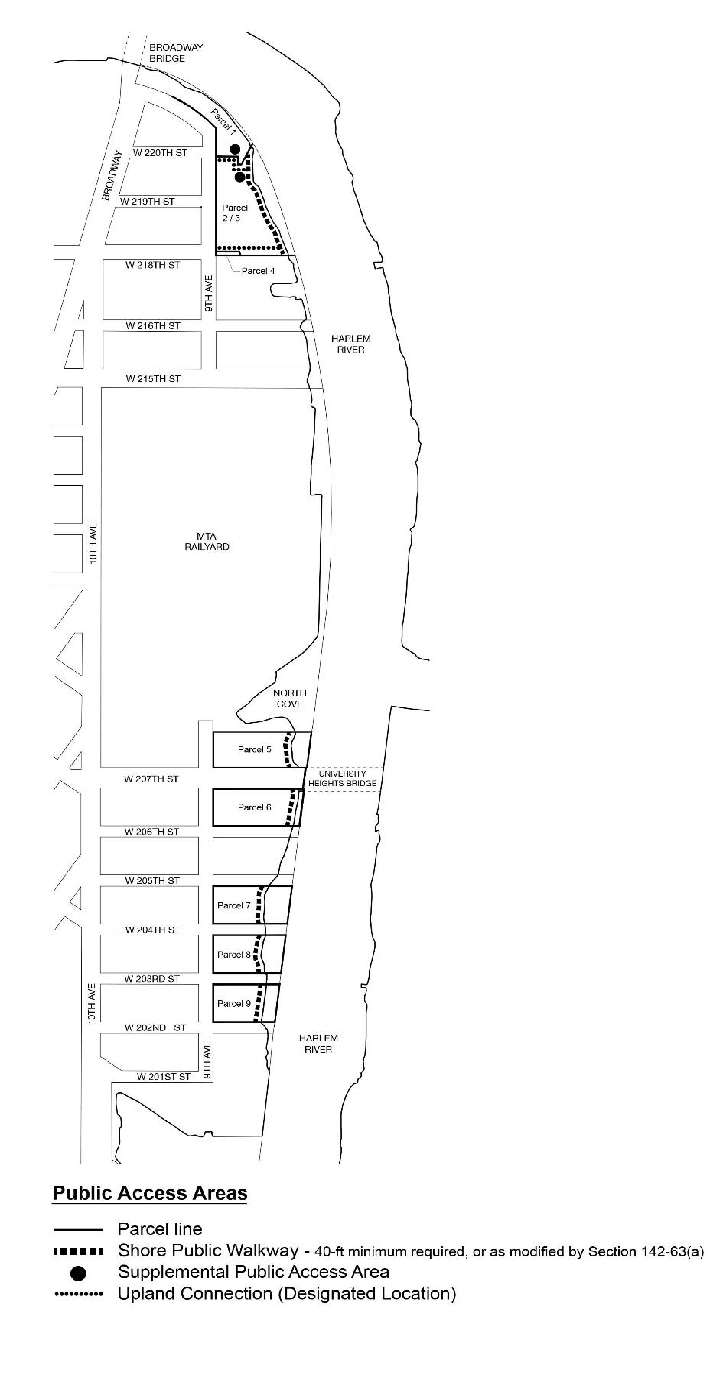
Map 4 (Waterfront Access Plan: Parcel Designation), Map 5 (Waterfront Access Plan: Public Access Areas) and Map 6 (Waterfront Access Plan: Visual Corridors) in the Appendix to this Chapter show the boundaries of the area comprising the Inwood Waterfront Access Plan, boundaries of parcels within the Plan and the location of certain features mandated or permitted by the Plan.
The Plan has been divided into parcels consisting of tax blocks and lots and other lands as established on August 8, 2018, as follows:
Parcel 1: block 2215, lots 877 and 885; and block 2197, lots 67, 71, 74 and 174
Parcel 2/3: block 2197, lots 47 and 75
Parcel 4: block 2197, portion of lot 1
Parcel 5: block 2188, lot 1
Parcel 6: block 2187, lots 1, 5, 7 and 20
Parcel 7: block 2185, lots 25, 36 and 51
Parcel 8: block 2185, lots 1 and 10
Parcel 9: block 2184, lots 20 and 40
Within the Special Inwood District, the parcels of land designated in this Section need not be contiguous for the area to be considered to be a Waterfront Access Plan pursuant to Section 62-911.
For the purposes of this Section, inclusive, defined terms shall include those listed in Section 12-10 (DEFINITIONS) and Section 62-11 (Definitions).
For the purposes of determining requirements for waterfront public access areas, lot area shall not include any portion of a zoning lot that is seaward of the shoreline. For the purposes of determining the applicability of waterfront public access area requirements, pursuant to Section 62-52, all zoning lots with portions located within 40 feet of the shoreline shall be considered waterfront zoning lots.
On Parcel 1, as shown on Map 4 (Waterfront Access Plan: Parcel Designation) in the Appendix to this Chapter, for the purposes of calculating the total waterfront public access area requirements on a “granting lot,” as described in Section 142-23 (Floor Regulations in Subarea B2 and B3), lot area shall be the combined lot area of all “granting lots” and all “receiving lots.”
In Tip of Manhattan Subdistrict B, for Parcels 1 and 2/3, as shown on Map 4 (Waterfront Access Plan: Parcel Designation) in the Appendix to this Chapter, the following regulations shall apply.
- Applicability of waterfront public access area requirements to Use Group IX(C)
In Subarea B1, as shown on Map 1, developments of buildings containing exclusively commercial or public utility vehicle storage, including accessory fuel pumps, as listed in Use Group IX(C), shall be exempted from waterfront public access area requirements. - Shore public walkways
On Parcel 1, no shore public walkway shall be required. - Upland connections
On Parcel 2/3, upland connections shall be provided along the shared boundary between Parcels 1 and 2/3, and within the area located between a line parallel to and 20 feet south of the prolongation of the centerline of West 218th Street and a line parallel to and 30 feet north of such centerline. - Supplemental public access areas
- on Parcel 1, supplemental public access area shall be bounded by Ninth Avenue to the west, the shared boundary of Parcels 1 and 2/3 to the south, and the stabilized shore to the east. Section 62-571 (Location and area requirements for supplemental public access areas) shall not apply to such supplemental public access area;
- on Parcel 2/3, supplemental public access area, if required, shall be located at the intersection of the upland connection and the shore public walkway. Section 62-571 shall be modified to allow the longest side of such supplemental public access area to adjoin the upland connection provided that the maximum depth measured perpendicular to the upland connection does not exceed 1.5 times the width measured parallel to the upland connection.
- Visual corridors
Visual corridors shall be provided at three locations as shown on Map 6 (Waterfront Access Plan: Visual Corridors) in the Appendix to this Chapter:- within the prolongation of the street lines of West 220th Street;
- within the prolongation of the street lines of Ninth Avenue;
- within the area located between a line parallel to and 20 feet south of the prolongation of the centerline of West 218th Street and a line parallel to and 30 feet north of such centerline. In the event that such visual corridor abuts an open area with a minimum depth of 20 feet along the entire length of such visual corridor, and an easement for such open area has been recorded against the property, the minimum dimension of a visual corridor set forth in Section 62-512 (Dimensions of visual corridors) may be reduced to 30 feet.
Sherman Creek Subdistrict A
In the Sherman Creek Subdistrict A, Parcels 5, 6, 7, 8 and 9, as shown on Map 4 (Waterfront Access Plan: Parcel Designation) in the Appendix to this Chapter, the following regulations shall apply.
(a) Shore public walkways
(1) Waterfront zoning lots that have a shoreline measuring more than 100 feet shall provide a shore public walkway as required by Section 62-53 (Requirements for Shore Public Walkways).
(2) Zoning lots within or partially within 40 feet of the shoreline that do not abut the shoreline, or that contain a shoreline measuring 100 feet or less shall provide either:
(i) a shore public walkway, located partly on the zoning lot and partly on an adjoining waterfront zoning lot; or
(ii) a shore public walkway on any portion of the zoning lot within 40 feet of the shoreline. Such shore public walkway shall have a minimum width of 14 feet, and its pedestrian circulation path shall connect to and provide access from adjoining public streets, parks or public places. Such shore public walkway shall extend beyond 40 feet of the shoreline as necessary to satisfy the minimum dimensional requirements, but the total area of the shore public walkway need not exceed an area equivalent to that portion of the zoning lot within 40 feet of the shoreline. The provisions of Section 62-62 (Design Requirements for Shore Public Walkways and Supplemental Public Access Areas) shall be modified to allow the circulation path to have a minimum width of 10 feet and to be located entirely beyond 10 feet from the shoreline. In addition, for Parcels 6, 7 or 8, the planting requirements set forth in paragraph (c)(1) of Section 62-62 need not apply.
Where the zoning lot does not include all of the adjacent shoreline, the design of the shore public walkway shall be compatible with the future improvement of public access areas on the land between the zoning lot and the shoreline.
(3) The primary circulation path required pursuant to Section 62-62 shall be provided at a minimum elevation of 7.5 feet above the shoreline, except that such requirement need not include portions of a circulation path that slope downward to meet the elevation of an existing publicly accessible sidewalk.
(b) Supplemental public access areas
On Parcel 5, no supplemental public access area shall be required.
(a) Section 62-811 (Waterfront public access and visual corridors) shall not apply to Parcel 5, as shown on Map 4 (Waterfront Access Plan: Parcel Designation) in the Appendix to this Chapter. In lieu thereof, the following regulations shall apply:
Required Certification
No excavation or building permit shall be issued for any development on Parcel 5 until the Chairperson of the City Planning Commission has certified to the Department of Buildings, that:
(1) a site plan has been submitted showing compliance with the provisions of Sections 62-50 (GENERAL REQUIREMENTS FOR VISUAL CORRIDORS AND WATERFRONT PUBLIC ACCESS AREAS) and 62-60 (DESIGN REQUIREMENTS FOR WATERFRONT PUBLIC ACCESS AREAS) as modified by Section 142-60 (INWOOD WATERFRONT ACCESS PLAN);
(2) the Chairperson has certified that an easement, the requirements for which shall be determined in consultation with the Department of Transportation, has been provided to enlarge the adjoining mapped streets, an instrument creating such easement has been recorded in the Office of the City Register, and a certified copy of such easement has been submitted to the Department of City Planning; and
(3) an acceptable restrictive declaration is executed and filed pursuant to Section 62-74 (Requirements for Recordation).
(b) Buildout of Adjoining Streets
No certificate of occupancy for any development on Parcel 5 shall be issued until the Department of Buildings has been furnished with a certification by the Department of Transportation that adjoining mapped streets have been built out to Department of Transportation standards.
Within 45 days of receipt of a complete application, the Chairperson shall either certify that the proposed development complies with the requirements of this Section or disapprove such application, citing the nature of any failure to comply. Failure to certify or disapprove such application within the 45 day period will release the Department of Buildings or the Department of Small Business Services from any obligation to withhold the excavation or building permit and authorize such agency to determine compliance with the provisions of this Section.
APPENDIX
Special Inwood District Plan
Map 1. Special Inwood District – Subdistricts and Subareas
Map 2. Special Inwood District – Ground Floor Use and Curb Cut Regulations

Map 3. Special Inwood District – Transit Easement Zones
Map 4. Waterfront Access Plan: Parcel Designation
Map 5. Waterfront Access Plan: Public Access Areas
Map 6. Waterfront Access Plan: Visual Corridors