Chapter 5 - Special Southern Hunters Point District (SHP)
GENERAL PURPOSES
The "Special Southern Hunters Point District" established in this Resolution is designed to promote and protect public health, safety and general welfare. These general goals include, among others, the following specific purposes:
(a) to encourage well-designed buildings that complement the built character of the Hunters Point neighborhood;
(b) to maintain and reestablish physical and visual public access to and along the waterfront;
(c) to broaden the regional choice of residences by introducing new affordable housing;
(d) to achieve a harmonious visual and functional relationship with the adjacent neighborhood;
(e) to create a lively and attractive built environment that will provide daily amenities and services for the use and enjoyment of area residents, workers and visitors;
(f) to take maximum advantage of the beauty of the East River waterfront and provide an open space network comprised of public parks, public open space and public access areas;
(g) to provide flexibility of architectural design within limits established to assure adequate access of light and air to the street, and thus to encourage more attractive and economic building forms; and
(h) to promote the most desirable use of land in accordance with the district plan for Southern Hunters Point, thus conserving the value of land and buildings, thereby protecting the City’s tax revenues.
General Provisions
In harmony with the general purpose and intent of this Resolution and the general purposes of the Special Southern Hunters Point District, the regulations of this Chapter shall apply within the Special Southern Hunters Point District. The regulations of all other Chapters of this Resolution are applicable, except as superseded, supplemented or modified by the provisions of this Chapter. In the event of a conflict between the provisions of this Chapter and other regulations of this Resolution, the provisions of this Chapter shall control. However, in flood zones, or for transit-adjacent sites or qualifying transit improvement sites, as defined in Section 66-11 (Definitions), in the event of a conflict between the provisions of this Chapter and the provisions of Article VI, Chapter 4 (Special Regulations Applying in Flood Hazard Areas), or Article VI, Chapter 6 (Special Regulations Applying Around Mass Transit Stations), the provisions of Article VI shall control.
District Plan and Maps
The regulations of this Chapter are designed to implement the Special Southern Hunters Point District Plan.
The District Plan, in Appendix A of this Chapter, includes the following maps:
Map 1. Special Southern Hunters Point District, Subdistricts and Parcels
Map 2. Special Ground Floor Use Regulations
Map 3. Street Wall Location
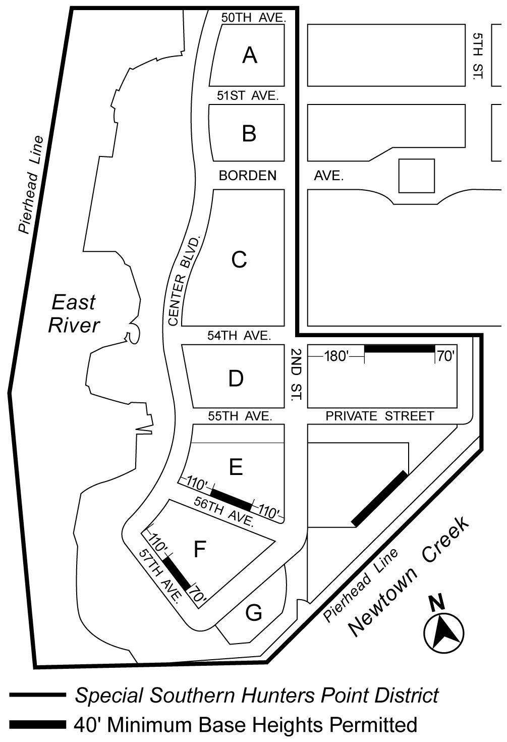
Map 4. Minimum Base Heights of 40 Feet
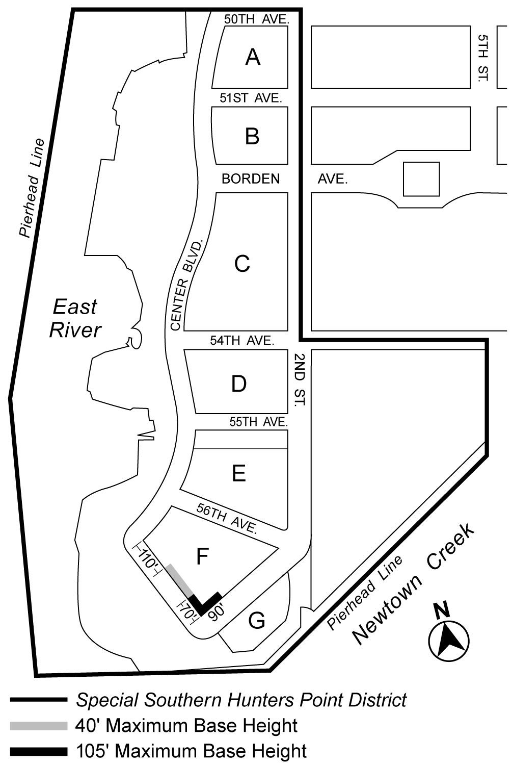
Map 5. Maximum Base Heights Other Than 70 Feet
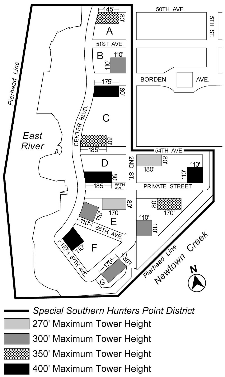
Map 6. Tower Areas
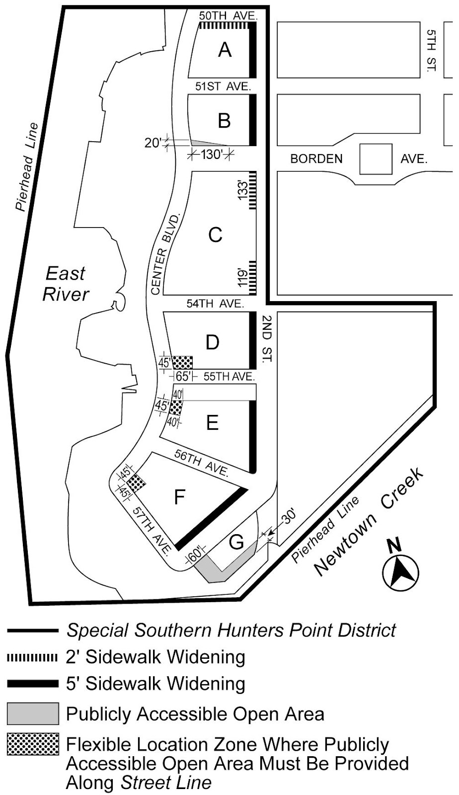
Map 7. Mandatory Sidewalk Widenings and Publicly Accessible Open Area
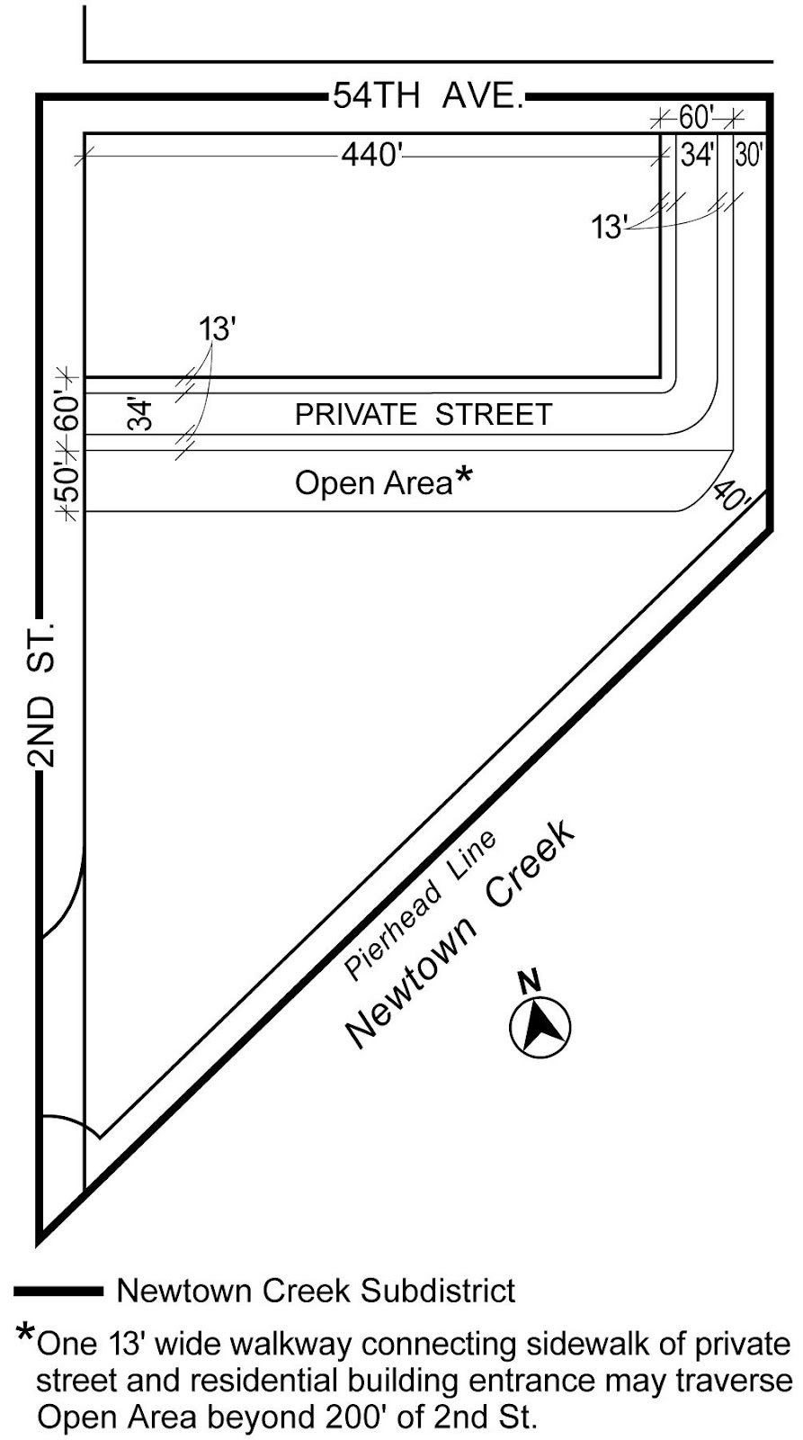
Map 8. Publicly Accessible Private Street and Open Area in Newtown Creek Subdistrict
Map 9. Newtown Creek Waterfront Access Plan (Q-3)
Map 10. Permitted Curb Cut Locations
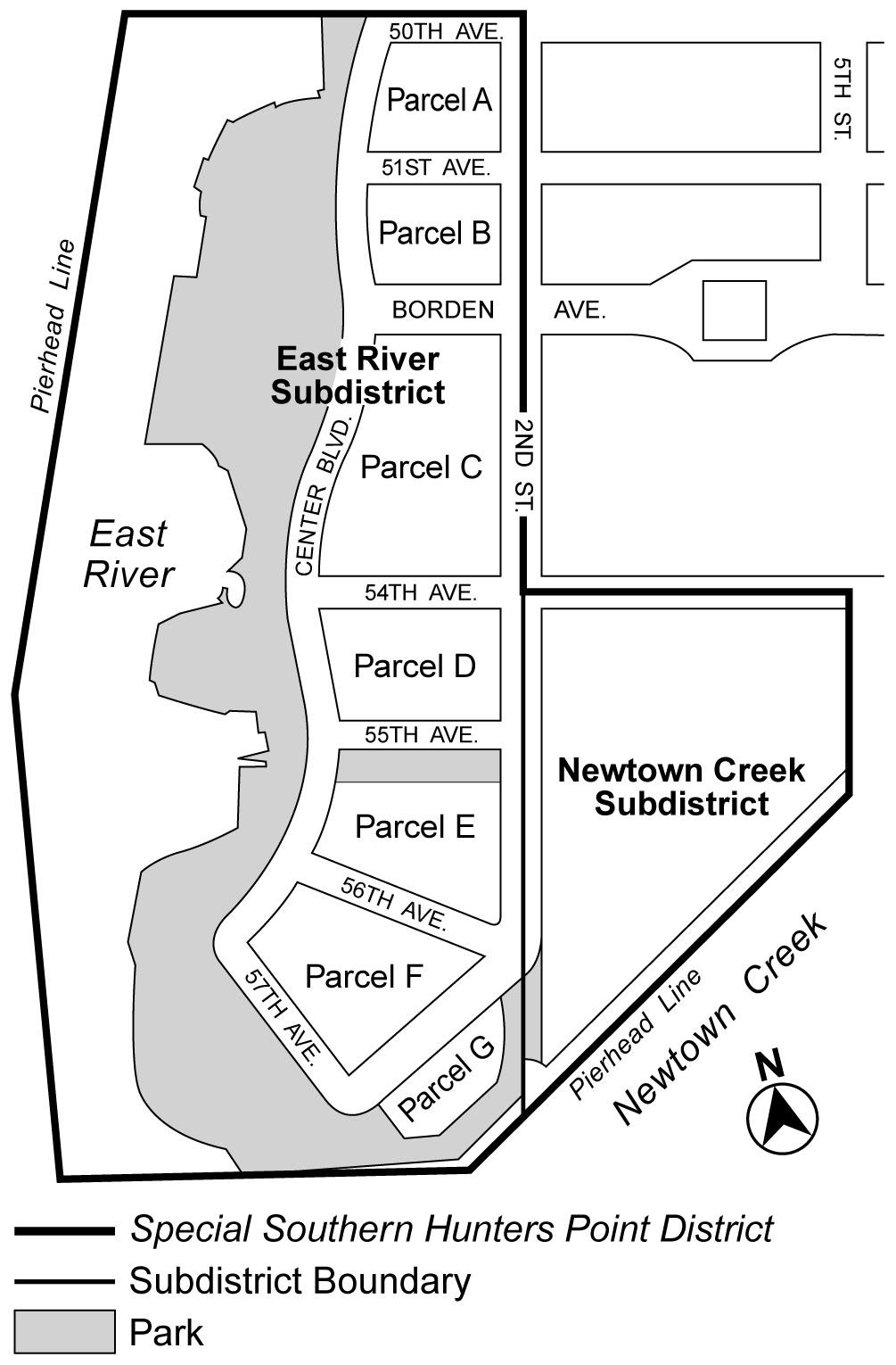
Subdistricts
In order to carry out the purposes and provisions of this Chapter, the Special Southern Hunters Point District is divided into two subdistricts: the East River Subdistrict and the Newtown Creek Subdistrict. The East River Subdistrict is further subdivided into parcels A through G. The location and boundaries of the subdistricts and parcels are shown on Map 1 (Special Southern Hunters Point District, Subdistricts and Parcels), in Appendix A of this Chapter.
Where the lot line of a zoning lot coincides with the boundary of a public park, such lot line shall be considered to be a street line for the purposes of applying all use and bulk regulations of this Resolution.
The provisions of Section 25-86 (Waiver or Reduction of Spaces for Subsidized Housing) shall not apply in the Special Southern Hunters Point District.
USE REGULATIONS
Streetscape Regulations
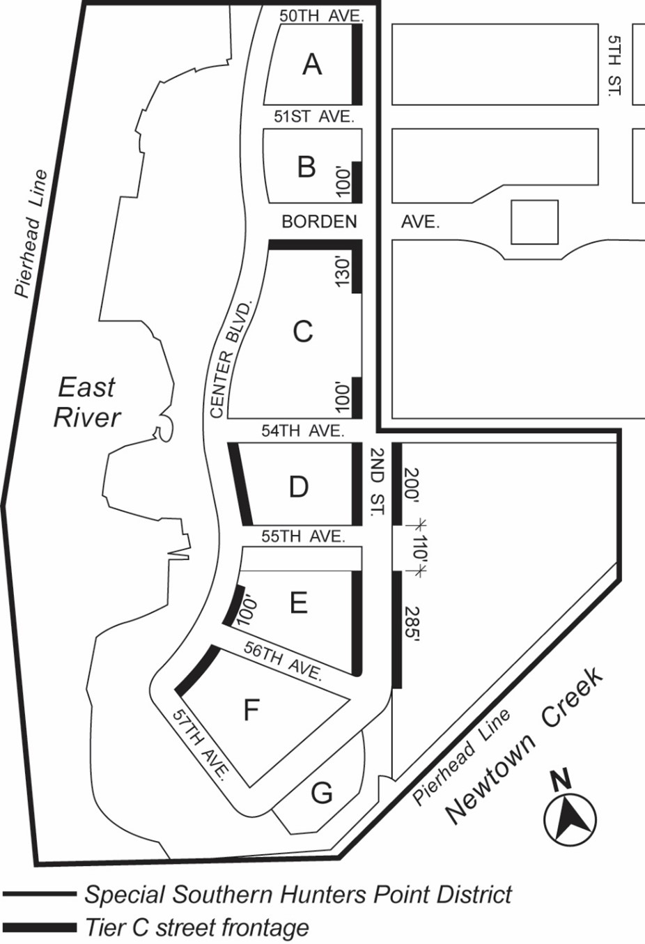
The underlying ground floor level streetscape provisions set forth in Section 32-30 (STREETSCAPE REGULATIONS), inclusive, shall apply, except that ground floor level street frontages along streets, or portions thereof, designated on Map 2 (Special Ground Floor Use Regulations) in Appendix A of this Chapter shall be considered Tier C street frontages. In addition, for the purposes of applying the underlying streetscape regulations, any street that abuts the park space designated on Map 1 shall be considered a wide street.
Defined terms in this Section shall include those in Sections 12-10 and 32-301.
In C2 Districts, the provisions of Section 32-422 (Location of floors occupied by commercial uses) shall apply in lieu of Section 32-421 (Limitation on floors occupied by commercial uses). In addition, the provisions of Section 32-422 shall be modified such that the limitations set forth in paragraph (a) of such Section need not apply, and the requirements in paragraph (b) of such Section shall apply only where commercial uses are located above any story containing dwelling units.
FLOOR AREA REGULATIONS
East River Subdistrict
In the East River Subdistrict, the basic maximum residential floor area ratio for zoning lots containing standard residences shall be as set forth in the following table. On Parcels B, C, and F, the maximum residential floor area ratio for zoning lots containing qualifying affordable housing or qualifying senior housing shall be as set forth in Section 23-22 (Floor Area Regulations for R6 Through R12 Districts) for R10 Districts. For developments or enlargements on qualifying transit improvement sites, a floor area bonus for mass transit station improvements may be granted by the City Planning Commission pursuant to the provisions of Section 66-51 (Additional Floor Area for Mass Transit Station Improvements). No other floor area bonuses shall apply. For the purposes of this paragraph, defined terms additionally include those in Section 66-11 (Definitions).
|
Parcel |
Maximum Floor Area |
|
A |
12.0 |
|
B |
10.0 |
|
C |
10.5 |
|
D |
12.0 |
|
E |
12.0 |
|
F |
10.0 |
|
G |
12.0 |
Newtown Creek Subdistrict
In the Newtown Creek Subdistrict, the maximum floor area ratio shall be 3.15, and may be increased only as set forth in this Section.
- Floor area bonus for public amenities
For developments located within the Newtown Creek Subdistrict that provide a publicly accessible private street and open area, the floor area ratio may be increased from 3.15 to a maximum permitted floor area ratio of 4.15, provided that the Chairperson of the City Planning Commission has certified that such publicly accessible private street and open area comply with the design standards of Sections 125-44 (Private Street Requirements in Newtown Creek Subdistrict) and 125-45 (Publicly Accessible Open Area in Newtown Creek Subdistrict). - Floor area for qualifying affordable housing or qualifying senior housing
In the Newtown Creek Subdistrict, for developments that provide a publicly accessible private street and open area that comply with the provisions of paragraph (a) of this Section, the maximum residential floor area ratio for zoning lots containing qualifying affordable housing or qualifying senior housing shall be 5.0.
The underlying height and setback regulations shall be modified by the provisions of this Section, inclusive. All heights shall be measured from the base plane.
Permitted Obstructions
The provisions of Section 33-42 (Permitted Obstructions) shall apply to all buildings within the Special Southern Hunters Point District, except that dormers provided in accordance with paragraph (b) of Section 23-413 (Permitted obstructions in certain districts) shall be a permitted obstruction in a required setback.
Balconies
Balconies shall not be permitted below a height of 70 feet. Above a height of 70 feet, balconies are permitted in accordance with the provisions of Section 23-62 (Balconies).
Required Street Walls
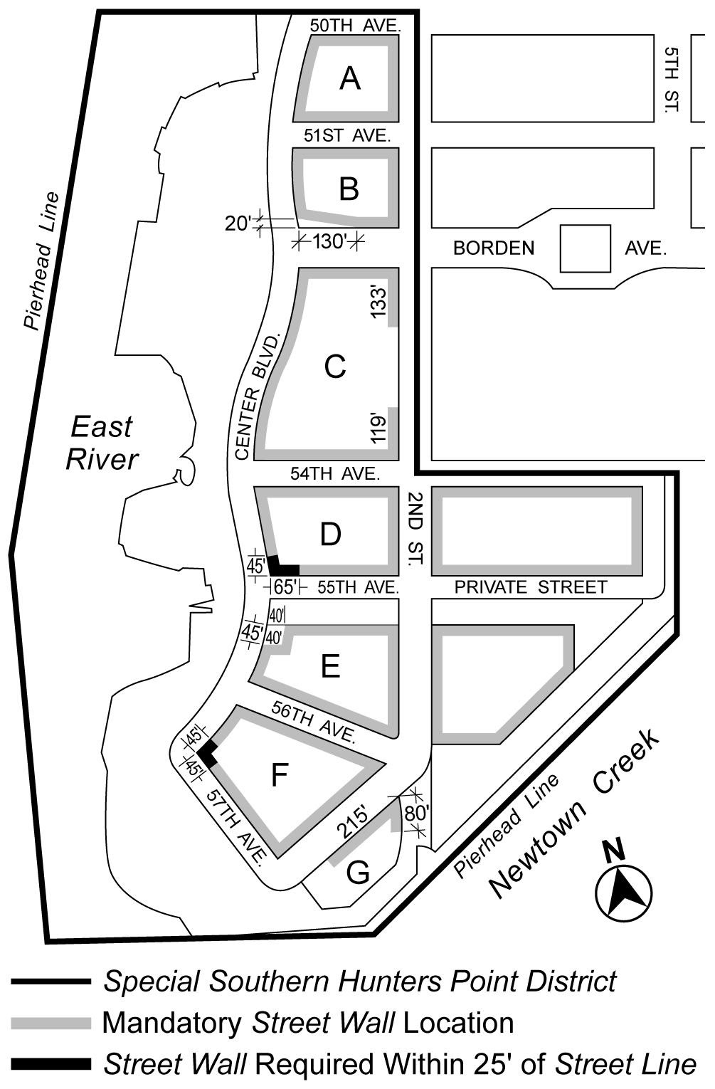
- Street wall location
The street wall location provisions of paragraph (a) of Section 35-631 shall apply to all designated street frontages shown on Map 3 (Street Wall Locations) in Appendix A of this Chapter, except that at the intersection of certain street lines, such map designates areas where the street wall shall be chamfered, and where the street wall shall be located within 25 feet of the street line. The street walls shall extend up to the minimum base height specified in paragraph (b), as applicable, or the height of the building, whichever is less. For the purposes of applying the height and setback provisions, all streets shall be considered wide streets.
Additionally, wherever a building fronts upon any public park, or any sidewalk widening, publicly accessible open area or private street provided in accordance with the design requirements of Sections 125-41 through 125-46, inclusive, the boundary of such public park, sidewalk widening, publicly accessible open area or private street shall be considered a wide street line. - Minimum base heights
All street walls shall extend up to at least a minimum base height of 50 feet or the height of the building, whichever is less, except that a minimum base height of 40 feet shall be permitted in the locations specified on Map 4 (Minimum Base Heights of 40 Feet) in Appendix A of this Chapter. - Maximum base heights
The maximum height of a street wall before setback shall be 70 feet, except in the locations specified on Map 5 (Maximum Base Heights Other Than 70 Feet) in Appendix A of this Chapter. - Required setbacks and maximum building heights
Setbacks are required for all portions of buildings that exceed the applicable maximum base height, except schools. All required setbacks shall be provided at a height not lower than the applicable minimum base height. A setback with a depth of at least 10 feet shall be provided from any street wall fronting on a wide street, and a setback with a depth of at least 15 feet shall be provided from any street wall fronting on a narrow street, except that the depth of such setbacks may include the depth of any permitted recesses in the street wall. For the purposes of this paragraph (c), the following shall be considered wide streets:- Second Street between 54th Avenue and Borden Avenue
- 55th Avenue between Center Boulevard and Second Street
- Center Boulevard between 50th Avenue and 57th Avenue.
Above the applicable maximum base height, the maximum height of a building or other structure shall be 125 feet, except where towers are permitted, pursuant to Section 125-34.
Towers
Any portion of a building that exceeds a height of 125 feet shall comply with the following provisions:
- Tower location and maximum tower height
All towers shall be located entirely within a Tower Area as designated on Map 6 (Tower Areas), in Appendix A of this Chapter. The maximum height of such towers shall be as indicated for the specified location on Map 6. For buildings higher than 165 feet, the gross area of all stories entirely within 40 feet of the highest roof level of the building shall be at least 50 percent and shall not exceed 90 percent of the gross area of that story located directly below the stories within 40 feet of the highest roof level. - Orientation and maximum tower size
The outermost walls of each story located entirely above a height of 125 feet shall be inscribed within a rectangle. The maximum length of any side of such rectangle that is parallel or within 45 degrees of being parallel to Second Street or Center Boulevard, whichever is closest, shall be 100 feet. The maximum length of any other side of such rectangle shall be 170 feet. Each story of a tower located entirely above a height of 125 feet shall not exceed a gross area of 11,000 square feet.
However, on Parcel G in the East River Subdistrict, the maximum length of the side of such rectangle that is parallel or within 45 degrees of being parallel to Second Street shall not exceed 170 feet. - Tower and base integration
Notwithstanding the setback provisions of paragraph (c) of Section 125-33 (Required Street Walls), up to 50 percent of the street wall width of a tower may rise sheer from grade without setback. The underlying dormer provisions of paragraph (b)(1) of Section 23-413 (Permitted obstructions in certain districts) shall be superseded by this Section for tower portions of buildings.
Within the Special Southern Hunters Point District, for any development or enlargement, the City Planning Commission may modify the regulations set forth in Section 125-30, inclusive, provided the Commission finds that such modifications:
(a) will result in a better distribution of bulk on the zoning lot and will not adversely affect access to light and air for surrounding public access areas, streets and properties;
(b) are consistent with the goals of the Special District to provide flexibility of architectural design and encourage more attractive building forms; and
(c) will result in a development or enlargement that enhances the streetscape and is compatible with development in the surrounding area.
The Commission may prescribe additional conditions and safeguards to minimize adverse effects of the development or enlargement on the character of the surrounding area.
DISTRICT PLAN ELEMENTS
Sidewalk Widenings
Map 7 (Mandatory Sidewalk Widenings and Publicly Accessible Open Area), in Appendix A of this Chapter, shows locations of mandatory sidewalk widenings in the East River Subdistrict. The depth of such sidewalk widenings shall be as indicated on Map 7 and shall be measured perpendicular to the street line unless otherwise indicated. All sidewalk widenings shall be improved to Department of Transportation standards for sidewalks, shall be at the same level as the adjoining public sidewalk, and shall be accessible to the public at all times.
Parcels B, D, E and F
Map 7 (Mandatory Sidewalk Widenings and Publicly Accessible Open Area), in Appendix A of this Chapter, shows locations where open areas are permitted or required on Parcels B, D, E and F in the East River Subdistrict. Where any such area is provided, it shall be publicly accessible and comply with the standards of Sections 37-741 (Seating), 37-743 (Lighting and electrical power), 37-744 (Litter receptacles), 37-745 (Bicycle parking), 37-746 (Drinking fountains), 37-747 (Public space signage), 37-76 (Mandatory Allocation of Frontages for Permitted Uses) and 37-77 (Maintenance).
In addition, the provisions of Section 37-742 (Planting and trees) shall apply to such open areas, and shall be modified to require that:
(a) at least 30 percent of each open area be comprised of planting beds;
(b) at least two four-inch caliper trees or three ornamental trees be provided within such open areas on Parcels D and F; and
(c) no trees shall be required within the open areas on Parcels B and E.
A publicly accessible private open area shall be provided within the area of Parcel G in the East River Subdistrict as shown on Map 7 (Mandatory Sidewalk Widenings and Publicly Accessible Open Area) in Appendix A of this Chapter. No excavation or building permit shall be issued for any development on such parcel until the Chairperson of the City Planning Commission certifies to the Department of Buildings that a site plan for such open area has been submitted that is consistent with the Department of Parks and Recreation design standards used for the development of the adjacent public park. A certification under this paragraph shall be granted on condition that an acceptable restrictive declaration is executed and filed, binding the owners, successors and assigns to develop such publicly accessible private open area in accordance with the approved site plan and to maintain such open area in accordance with maintenance standards acceptable to the Department of Parks and Recreation.
In the event that Parcel G is not owned by the City, then, prior to design and development of the publicly accessible open area, the owner of Parcel G may make a request directed to the Office of the Mayor to transfer to the City its fee simple absolute interest, free and clear of any encumbrances in the open area. The City may accept the transfer request, provided that development of the open area is made in accordance with guidelines established by the Chairperson of the City Planning Commission and the Commissioner of the Department of Parks and Recreation, and transfer is made pursuant to such instruments as are necessary for implementation. In the event of a transfer, the bulk and parking computations for the zoning lot shall include the transferred property and such transfer shall not be deemed a non-compliance.
In the Newtown Creek Subdistrict, where a private street is provided pursuant to paragraph (a) of Section 125-22, such private street shall be constructed to minimum Department of Transportation standards for public streets, including lighting, curbs and curb drops. Such private street shall consist of a paved road bed with a minimum width of 34 feet from curb to curb with 13 foot wide sidewalks on each side along its entire length. Such private street shall be located as shown on Map 8 (Publicly Accessible Private Street and Open Area in Newtown Creek Subdistrict) in Appendix A of this Chapter. One tree shall be planted for every 25 feet of curb length of the private street. Fractions equal to or greater than one-half resulting from this calculation shall be considered to be one tree. Such trees shall be planted at approximately equal intervals along the entire length of the curb of the private street.
Where a publicly accessible private open area is provided pursuant to paragraph (a) of Section 125-22, such open area shall be located as shown on Map 8 (Publicly Accessible Private Street and Open Area in Newtown Creek Subdistrict) in Appendix A of this Chapter. No excavation or building permit shall be issued for any development or enlargement on such parcel until the Chairperson of the City Planning Commission certifies to the Department of Buildings that a site plan for such open area has been submitted that is either:
(a) consistent with the Department of Parks and Recreation design standards for the public park located on 55th Avenue between Center Boulevard and Second Street; or
(b) in the event that design standards have not been developed for the public park located on 55th Avenue between Center Boulevard and Second Street, acceptable to the Chairperson of the City Planning Commission and the Department of Parks and Recreation.
A certification under this Section shall be granted on condition that an acceptable restrictive declaration is executed and filed, binding the owners, successors and assigns to develop such publicly accessible private open area in accordance with the approved site plan and to maintain such open area in accordance with maintenance standards acceptable to the Department of Parks and Recreation. Such approved plan shall allow for pedestrian access from 55th Avenue to the residential entrance of a building bounding the publicly accessible private open area. The paved width of such access shall not exceed 13 feet, and its location shall be within the area shown on Map 8.
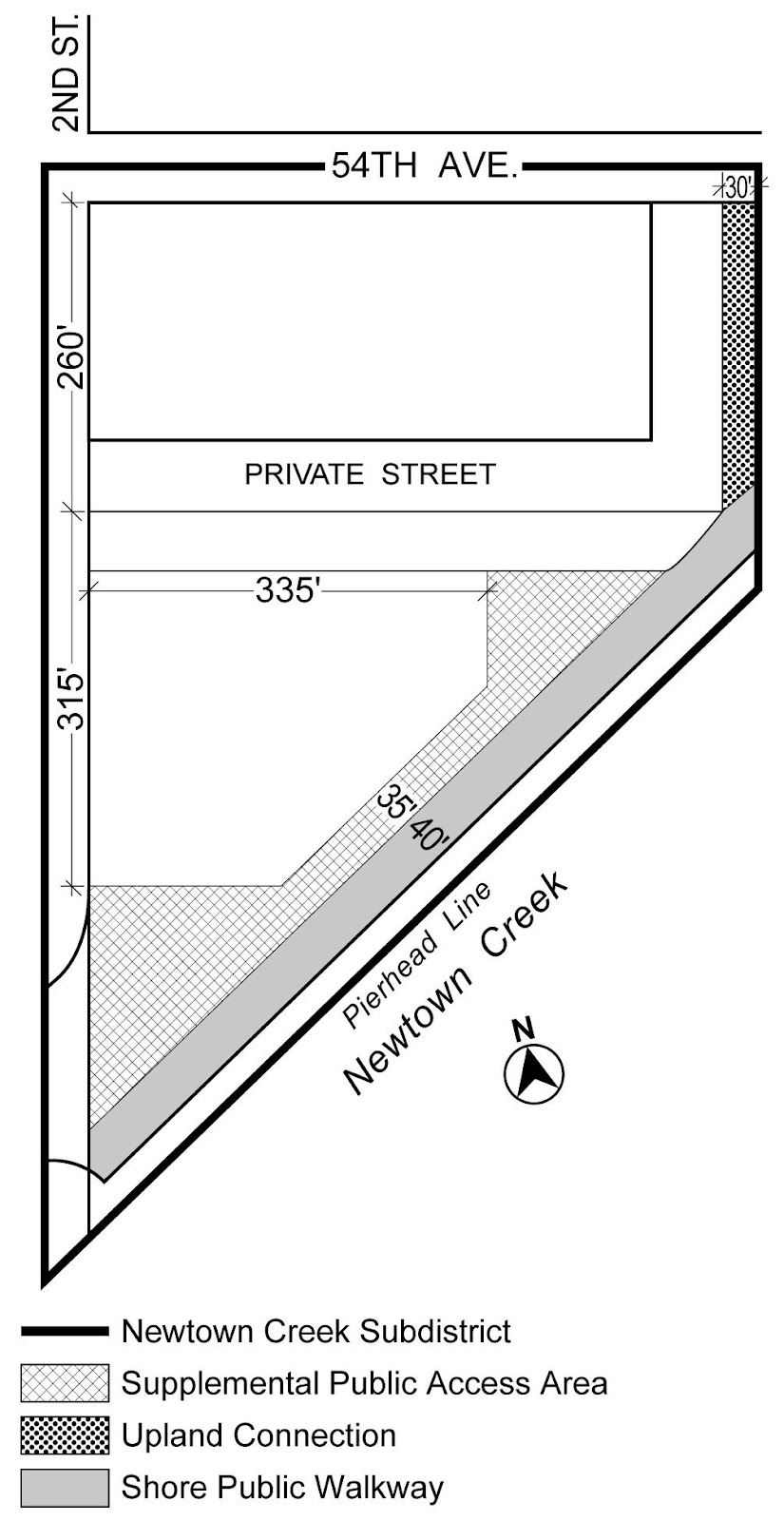
Map 9, in Appendix A of this Chapter, shows the boundaries of the area comprising the Newtown Creek Waterfront Access Plan and the location of certain features mandated or permitted by the Plan. The plan area consists of Block 11, Lot 1, as established on November 13, 2008.
- Modification of use requirements
Docks for water taxis and docks or mooring facilities for non-commercial pleasure boats, listed under Use Group IV(B), shall be permitted uses within the Newtown Creek Waterfront Access Plan. - Area-wide modifications
The requirements for waterfront public access area, as defined in Section 62-11, pursuant to Sections 62-53 through 62-57, inclusive, are modified at the following designated locations:- Upland connection
An upland connection, as defined in Section 62-11, shall be provided through Block 11, Lot 1, abutting the prolongation of 5th Street and extending from the shore public walkway, as defined in Section 62-11, northerly to 54th Avenue. - Supplemental public access area
Supplemental public access areas, as defined in Section 62-11, shall be provided as indicated on Map 9.
- Upland connection
In the Newtown Creek Subdistrict, the Chairperson of the City Planning Commission shall allow for the phased implementation of all required publicly accessible areas upon certification to the Commissioner of Buildings that a plan has been submitted that provides for an amount of public access area proportionate to the amount of floor area being developed or enlarged in each phase. For any development or enlargement located within 100 feet of a shoreline, the initial phase shall provide, at a minimum, the required shore public walkway and any adjacent supplemental public access areas located between such development or enlargement and such shore public walkway, as defined in Section 62-11. For any development or enlargement that fronts upon 54th Avenue, the initial phase shall provide, at a minimum, the required publicly accessible private street.
PARKING REGULATIONS
The regulations governing permitted and required accessory off-street parking spaces of Article I, Chapter 6 (Comprehensive Off-street Parking Regulations in the Long Island City Area) and Article II, Chapter 5; Article III, Chapter 6; and Article IV, Chapter 4 (Accessory Off-street Parking and Loading Regulations) shall apply, except as set forth in this Section.
General Regulations
For the purposes of Section 125-50 (PARKING REGULATIONS), inclusive, the floor area of a building shall not include floor space used for accessory off-street parking spaces provided in any story located not more than 33 feet above curb level.
No public parking garages or public parking lots shall be permitted.
Rooftop Landscaping
Any roof area of a parking garage not otherwise covered by a building and larger than 400 square feet shall be landscaped. Up to five percent of such roof area may be used for mechanical equipment, provided that such mechanical equipment is screened from view by a fence which is at least 75 percent opaque or by at least three feet of dense planting. Up to 25 percent of such roof area may be accessible solely from an adjacent dwelling unit and the remaining roof area shall be accessible for the recreational use of the occupants of the building in which it is located. Hard surfaced areas shall not cover more than 50 percent of such roof area. Schools shall be exempt from the provisions of this paragraph (b).
In the East River Subdistrict, Section 16-13 (Permitted Parking for Zoning Lots With Multiple Uses) shall apply, except that the maximum number of spaces shall be 780. Additionally, the restrictions for off-site parking pursuant to Section 16-21 (Public Use and Off-site Parking) shall not apply.
In the Newtown Creek Subdistrict, Section 16-13 shall apply except that the maximum number of spaces shall not exceed 40 percent of the number of dwelling units within the development or enlargement.
In the East River Subdistrict, all accessory off-street parking spaces may be provided within parking facilities on zoning lots other than the same zoning lot as the uses to which they are accessory, provided such parking facilities are located within the Special Southern Hunters Point District, and the number of parking spaces within such facility shall not exceed the combined maximum number of spaces permitted on each off-site zoning lot using such facility, less the number of any spaces provided on such zoning lots.
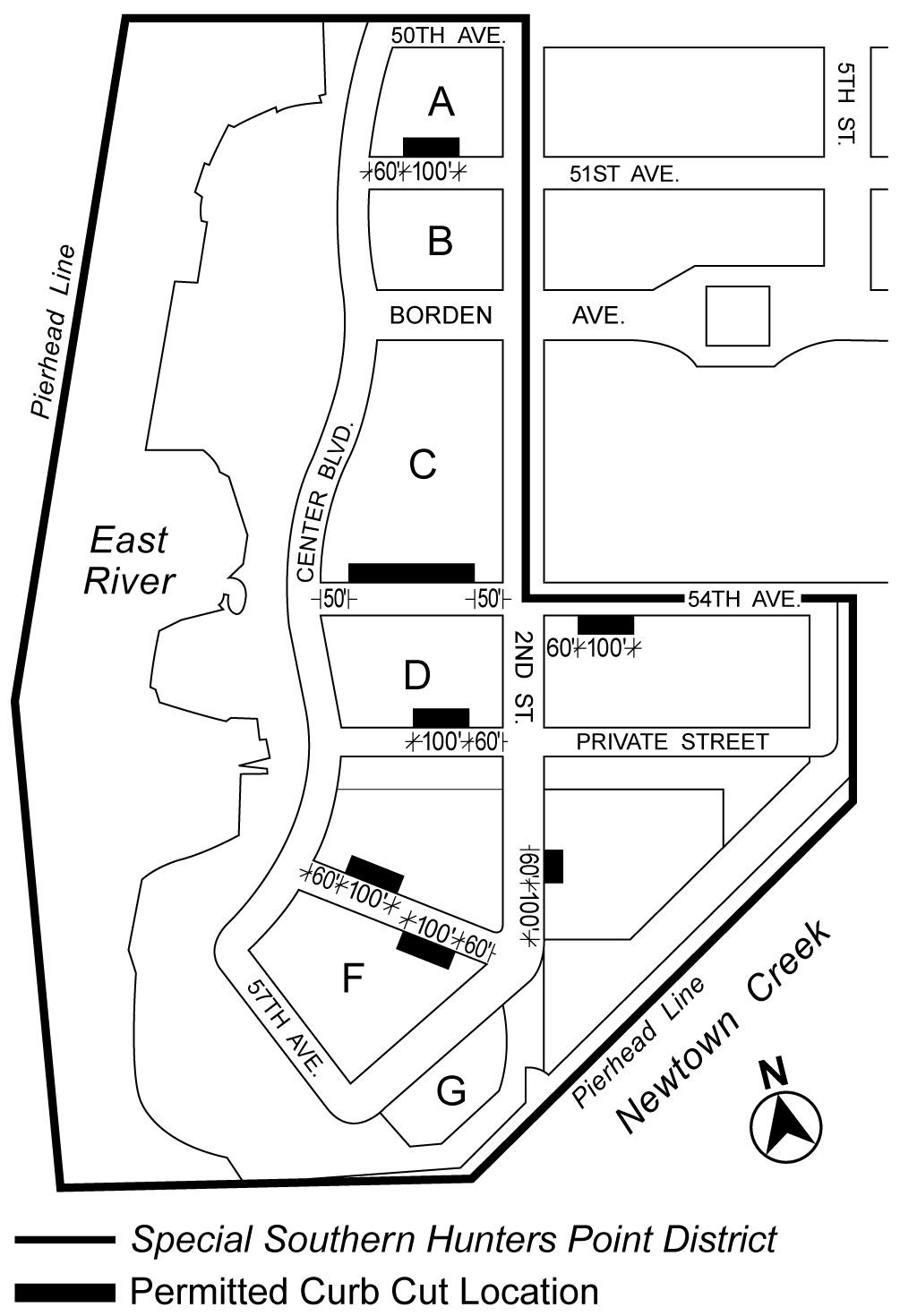
Location of Curb Cuts
Curb cuts are permitted only in the locations indicated on Map 10 (Permitted Curb Cut Locations) in Appendix A of this Chapter. The aggregate width of all curb cuts provided for any building shall not exceed 50 feet.
Appendix A
Special Southern Hunters Point District Plan
Map 1 – Special Southern Hunters Point District, Subdistricts and Parcels
Map 2 – Special Ground Floor Use Regulations
Map 3 – Street Wall Locations
Map 4 – Minimum Base Heights of 40 Feet
Map 5 – Maximum Base Heights other than 70 Feet
Map 6 – Tower Areas
Map 7 – Mandatory Sidewalk Widenings and Publicly Accessible Open Area
Map 8 – Publicly Accessible Private Street and Open Area in Newtown Creek Subdistrict
Map 9 – Newtown Creek Waterfront Access Plan (Q-3)
Map 10 – Permitted Curb Cut Locations