Chapter 7 - Special Harlem River Waterfront District (HRW)
GENERAL PURPOSES
The "Special Harlem River Waterfront District" established in this Resolution is designed to promote and protect public health, safety and general welfare. These general goals include, among others, the following specific purposes:
(a) to maintain and reestablish physical and visual public access to and along the waterfront;
(b) to create a lively and attractive built environment that will provide amenities and services for the use and enjoyment of area residents, workers and visitors;
(c) to promote the pedestrian orientation of ground floor uses in appropriate locations, and thus safeguard a traditional quality of higher density areas of the City;
(d) to encourage well-designed development that complements the built character of the neighborhood;
(e) to take advantage of the Harlem River waterfront and provide an open space network comprised of parks, public open space and public access areas;
(f) to provide flexibility of architectural design within limits established to assure adequate access of light and air to streets and public access areas, and thus encourage more attractive and economic building forms;
(g) to enhance neighborhood economic diversity by broadening the range of housing choices for residents at varied incomes;
(h) to encourage investment in mixed residential and industrial neighborhoods by permitting expansion and new development of a wide variety of uses in a manner that will safeguard the health and safety of people using the area; and
(i) to promote the most desirable use of land and building development in accordance with the District Plan for the Harlem River waterfront and thus conserve the value of land and buildings and thereby protect City tax revenues.
Definitions
For purposes of this Chapter, matter in italics is defined in Sections 12-10, 32-301, 62-11 or 64-11, or within this Section.
Ground floor level
The “ground floor level” shall mean the finished floor level of the first story that is within five feet of an adjacent public sidewalk or any other publicly accessible open area.
Major Deegan Expressway street line
The “Major Deegan Expressway street line” shall be:
- in the event that the portion of the Major Deegan Expressway traversing Parcels 1, 2, 3 or 4, as shown on Map 1 in the Appendix to this Chapter, has been widened after December 11, 2017, a line 22 feet west of and parallel to the as-built western edge of such Expressway structure for Parcel 1, and a line 14 feet west of and parallel to the as-built western edge of such Expressway for Parcels 2, 3, or 4; or
- in the event that the portion of the Major Deegan Expressway traversing Parcels 1, 2 , 3 or 4, as shown on Map 1 in the Appendix to this Chapter, has not been widened after December 11, 2017, a line connecting on:
- Parcel 1:
- a point located on the northern boundary of Parcel 1 that is 120 feet west of its intersection with the eastern parcel boundary; and
- a point on the southern boundary of Parcel 1 that is 110 feet west of its intersection with the eastern parcel boundary.
- Parcel 2:
- a point located on the northern boundary of Parcel 2 that is 74 feet west of its intersection with the eastern parcel boundary; and
- a point located on the southern boundary of Parcel 2 that is 74 feet west of its intersection with the eastern parcel boundary.
- Parcel 3:
- a point located on the northern boundary of Parcel 3 that is 74 feet west of its intersection with the eastern parcel boundary; and
- a point located on the southern boundary of Parcel 3 that is 30 feet west of its intersection with the eastern parcel boundary.
- Parcel 4:
- a point located on the northern lot line of Parcel 4 that is 30 feet west of its eastern lot line; and
- a point located on the eastern lot line of Parcel 4 that intersects with a line parallel to and 60 feet from the northern lot line.
- Parcel 1:
General Provisions
In harmony with the general purpose and intent of this Resolution and the general purposes of the Special Harlem River Waterfront District, the regulations of the Special Harlem River Waterfront District shall apply. The regulations of all other Chapters of this Resolution are applicable, except as superseded, supplemented or modified by the provisions of this Chapter. In the event of a conflict between the provisions of this Chapter and other regulations of this Resolution, the provisions of this Chapter shall control, except as specifically modified in this Chapter.
District Plan
The regulations of this Chapter are designed to implement the Special Harlem River Waterfront District Plan as set forth in the Appendix to this Chapter. The plan area has been divided into three Subdistricts comprised of parcels that consist of tax blocks and lots as follows:
Core Subdistrict - tax blocks and lots existing on June 30, 2009
Parcel 1: Block 2349, Lot 112
Parcel 2: Block 2349, Lot 100 (that portion not mapped as parkland in accordance with Alteration Map No. 13124, dated January 29, 2009, in the Office of the Bronx Borough President)
Parcel 3: Block 2349, Lots 46, 47, 146
Parcel 4: Block 2349, Lot 38
Parcel 5: Block 2349, Lots 15, 20
Parcel 6: Block 2349, Lots 3, 4
Parcel 7: Block 2323, Lot 43
Parcel 8: Block 2323, Lot 28
Parcel 9: Block 2323, Lots 5, 13, 18
North Subdistrict - tax blocks and lots existing on December 11, 2017
Parcel 10: Block 2539, Lot 1, portion of
Lots 2, 3
Block 2356, Lots 2, 72 and tentative
Lot 102 (existing on December 11, 2017)
South Subdistrict - tax blocks and lots existing on December 11, 2017
Parcel 11: Block 2319, Lot 55
Parcel 12: Block 2319, Lot 60
Parcel 13: Block 2319, Lots 37 and 155
Parcel 14: Block 2319, Lot 98
Parcel 15: Block 2319, Lot 99
Parcel 16: Block 2319, Lots 100 and 108
Parcel 17: Block 2319, Lot 109
Parcel 18: Block 2319, Lot 112
Parcel 19: Block 2319, Lot 2
Parcel 20: Block 2316, Lots 1 and 35
Parcel 21: Block 2319, Lot 200
The District Plan includes the following maps:
Map 1. (Special Harlem River Waterfront District, Subdistricts and Parcels)
Map 2. (Designated Non-residential Use Locations)
Map 3. (Waterfront Access Plan: Public Access Elements)
Map 4. (Waterfront Access Plan: Designated Visual Corridors)
Parcels 1, 2, 3 and 4, as shown on Map 1 (Special Harlem River Waterfront District and Parcels) in the Appendix to this Chapter, shall be considered waterfront zoning lots, notwithstanding the mapping of any streets on such parcels after June 30, 2009.
The provisions of Article VI, Chapter 2 (Special Regulations Applying in the Waterfront Area) shall apply in all waterfront areas, except as modified by the provisions of this Chapter.
For the purpose of applying the provisions of Article VI, Chapter 2, Parcels 1, 2, 3 and 4 within the Core Subdistrict, and any parcels having a boundary within 40 feet of a shoreline within the South Subdistrict, as shown on Map 1 (Special Harlem River Waterfront District, Subdistricts and Parcels) in the Appendix to this Chapter, shall be considered waterfront zoning lots, notwithstanding the mapping of any streets on such parcels after June 30, 2009 for the Core Subdistrict, and after December 11, 2017, for the South Subdistrict.
In flood zones, in the event of a conflict between the provisions of this Chapter and the provisions of Article VI, Chapter 4 (Special Regulations Applying in Flood Zones), the provisions of Article VI, Chapter 4, shall control.
Within the South Subdistrict, for M1 Districts mapped with a Residence District, the provisions of Article XII, Chapter 3 (Special Mixed Use District) for waterfront blocks shall apply, except as modified in this Chapter. In the event of a conflict between the provisions of Article XII, Chapter 3 and this Chapter, the provisions of this Chapter shall control.
The North Subdistrict, as shown on Map 1, shall be a Mandatory Inclusionary Housing area.
In the event that streets are mapped on Parcels 1, 2, 3 and 4 in the Core Subdistrict after June 30, 2009, and on any Parcel in the South Subdistrict after December 11, 2017, as shown on Map 1 in the Appendix to this Chapter, the area within such streets may continue to be considered part of the zoning lot for the purposes of applying floor area regulations of this Zoning Resolution.
SPECIAL USE REGULATIONS
The use regulations of the underlying districts and of Article VI, Chapter 2 (Special Regulations Applying in the Waterfront Area) are modified by the provisions of this Section, inclusive.
The special use provisions of this Section, inclusive, shall apply to zoning lots within the Core Subdistrict, as shown on Map 1 in the Appendix to this Chapter.
Commercial or public utility vehicle storage, including accessory motor fuel pumps, listed under Use Group IX(C), open or enclosed, shall be a permitted use on Parcel 5, as shown on Map 1 in the Appendix to this Chapter, provided that:
- such use is the primary use on Parcel 5;
- no more than 10,000 square feet of floor area shall be provided on Parcel 5; and
- a shore public walkway is provided as set forth in paragraph (a) of Section 87-71 (Special Public Access Provisions).
The streetscape provisions of Section 87-41, inclusive and the special height and setback regulations of Section 87-32, inclusive, shall not apply to such use. In lieu thereof, the applicable height and setback provisions of Article VI, Chapter 2 shall apply.
Location of commercial space
The provisions of Section 32-422 (Location of floors occupied by commercial uses) shall be modified such that the limitations set forth in paragraph (a) of such Section need not apply, and the requirements in paragraph (b) of such Section shall apply only where commercial uses are located above any story containing dwelling units.
Location of underground uses
Notwithstanding the provisions of Section 62-332 (Rear yards and waterfront yards), underground uses, such as parking garages, shall not be allowed in waterfront yards.
The special use provisions of this Section, inclusive, shall apply to zoning lots within the North Subdistrict, as shown on Map 1 in the Appendix to this Chapter.
In the North Subdistrict, the provisions of Section 32-422 (Location of floors occupied by commercial uses) shall apply in lieu of Section 32-421 (Limitation on floors occupied by commercial uses).
In addition, the provisions of Section 32-422 shall be modified such that the limitations set forth in paragraph (a) of such Section need not apply, and the requirements in paragraph (b) of such Section shall apply only where commercial uses are located above any story containing dwelling units.
The applicable floor area regulations of the underlying districts and of Article VI, Chapter 2 (Special Regulations Applying in the Waterfront Area), or of Article XII, Chapter 3 (Special Mixed Use District), are modified by the provisions of this Section, inclusive.
The provisions of this Section, inclusive, shall apply to developments and enlargements within the Core Subdistrict, as shown on Map 1 in the Appendix to this Chapter.
The maximum floor area ratio for zoning lots containing only standard residences, or such residential uses with community facility or commercial uses, shall be 3.33. The maximum floor area ratio for zoning lots containing qualifying affordable housing or qualifying senior housing shall be 4.0.
For each square foot of commercial floor area in a building occupied by uses listed under Use Groups VI or VIII an equal or greater amount of permitted residential, community facility or other permitted commercial floor area shall be provided.
However, the City Planning Commission may authorize a modification or waiver of this provision upon finding that such building includes:
- a superior site plan that enables safe and efficient pedestrian connectivity to and between establishments and publicly accessible areas;
- a superior parking and circulation plan that reduces conflicts between pedestrian and vehicular traffic, minimizes open parking lots and limits conflicts between curb cuts;
- a design that enhances and is integrated with publicly accessible areas including provision of a public entrance fronting on a waterfront public access area;
- a variety of retail establishments; and
- uses that do not unduly affect the residential uses in the nearby area or conflict with future land use and development of adjacent areas.
The Commission may prescribe appropriate conditions and safeguards to minimize adverse effects of any such uses on publicly accessible areas.
Within the North Subdistrict, as shown on Map 1 in the Appendix to this Chapter, for all permitted uses, the floor area provisions of Article VI, Chapter 2 (Special Regulations Applying in the Waterfront Area) shall apply. However, in no event shall the maximum floor area ratio for any zoning lot exceed 4.6.
In the Core Subdistrict, as shown on Map 1 in the Appendix to this Chapter, the underlying height and setback regulations shall apply, except as modified by the provisions of this Section, inclusive. The special height and setback regulations of Section 62-34 (Height and Setback Regulations on Waterfront Blocks), inclusive, shall not apply.
In the North Subdistrict, as shown on Map 1, the underlying height and setback regulations shall apply, except as modified by the provisions of this Section, inclusive, as applicable. The height and setback regulations of Section 62-34 (Height and Setback Regulations on Waterfront Blocks) shall not apply, except as specifically made applicable in this Section, inclusive.
In the South Subdistrict, as shown on Map 1, the height and setback and other bulk regulations of Article XII, Chapter 3 (Special Mixed Use District) applicable to M1 Districts mapped with an R8 District in waterfront blocks shall apply, except as modified in this Section, inclusive.
In all Subdistricts, the height of all buildings or other structures shall be measured from the base plane.
Permitted Obstructions
In the Core Subdistrict, as shown on Map 1 in the Appendix to this Chapter, for developments and enlargements, the provisions of this Section, inclusive, shall apply.
For the purposes of applying the special height and setback regulations of this Section, inclusive, and the provisions of the underlying height and setback, distance between legally required windows and lot lines, and court regulations, as applicable, a shore public walkway, mapped parkland, supplemental public access area, upland connection, or fire apparatus access road provided in accordance with the provisions of Section 87-61 (Special Provisions for Certain Fire Apparatus Access Roads), shall be considered a street and its boundary shall be considered a street line. In addition, the street line of Exterior Street shall be modified as follows:
(a) for Parcels 1, 2, 3 and 4, the westerly street line along Exterior Street shall be the Major Deegan Expressway street line or the street line of Exterior Street, whichever is closest to the shore line; and
(b) for Parcel 1, the street line of East 149th Street shall be the southernmost boundary of any easement area existing on December 11, 2017, any fire apparatus access road or any private road.
For Parcels 2, 3 and 4, where a fire apparatus access road in accordance with the provisions of Section 87-61 (Special Provisions for Certain Fire Apparatus Access Roads) is immediately adjacent to and contiguous with the shore public walkway, the fire apparatus access road shall be considered as part of the shore public walkway, and the street line shall be considered the boundary of the fire apparatus access road furthest from the shoreline. In addition, for Parcels 1 and 2, where a fire apparatus access road in accordance with the provisions of Section 87-61 is provided immediately adjacent to and contiguous with the northern or southern boundaries, as applicable, of the mapped parkland, the street line shall be considered the boundary of the fire apparatus access road furthest from the mapped parkland.
Street wall location
In the Core Subdistrict, the following street wall location rules shall apply.
Along the following frontages, the street wall location provisions of paragraph (b) of Section 23-431 shall apply, except that the street walls shall extend to the minimum base heights as specified in Section 87-322 (Base heights and transition heights):
- On Parcels 1, 2, 3 and 4, as shown on Map 1 in the Appendix to this Chapter, for frontages along the shore public walkway, supplemental public access areas, upland connections, mapped parkland or visual corridors, as shown on Map 2; and
- On Parcels 5, 6, 7, 8 and 9, as shown on Map 1, for frontages along visual corridors, or upland connections, as shown on Map 2.
Along other frontages, no street wall location provisions shall apply.
In the Core Subdistrict, the following base heights, required setbacks and maximum transition heights shall apply. Towers are permitted above the maximum heights set forth in this Section only in accordance with Section 87-323 (Tower provisions).
(a) Base heights
(1) Within 50 feet of the shore public walkway for street walls fronting on, or within 50 feet of, the shore public walkway, the maximum base height shall be 85 feet, except that:
(i) on Parcels 1, 2, 3 and 4, as shown on Map 1 in the Appendix to this Chapter, for street walls fronting on a shore public walkway, at least 30 percent of the aggregate width of street walls fronting on the shore public walkway, or a contiguous street wall width of 60 feet, whichever is greater, shall not exceed a maximum height of 45 feet. In addition to being applied along the shore public walkway, such lowered street wall may be applied along intersecting streets within 100 feet of the shore public walkway; and
(ii) on Parcels 5 and 6, as shown on Map 1, such maximum base height shall be 45 feet.
(2) Beyond 50 feet of the shore public walkway and beyond 50 feet of the Major Deegan Expressway street line
Along all other frontages beyond 50 feet of the shore public walkway and beyond 50 feet of the Major Deegan Expressway street line, the street wall shall rise without setback to a minimum base height of 60 feet, or the height of the building, whichever is less, and may rise to a maximum base height of 105 feet.
(3) Along, and within 50 feet of, the Major Deegan Expressway street line
Along, and within 50 feet of, the Major Deegan Expressway street line, the street wall shall rise without setback to a minimum base height of 15 feet, or the height of the building, whichever is less, and may rise to a maximum base height of 105 feet.
(b) Required setbacks
Above such maximum base height, street walls shall be set back a minimum of 30 feet from the street line along the shore public walkway on Parcel 1, 15 feet from such street line along the shore public walkway on any other parcels, and a minimum of 10 feet from the street line along all other streets. Such setbacks may be modified pursuant to the provisions of Section 23-433, except that on Parcel 1 along the shore public walkway dormers may not exceed a depth of 15 feet.
In addition, on Parcels 1, 2, 3 and 4, in locations where the maximum base height is limited to 45 feet, street walls above such maximum base height shall be set back a minimum of 30 feet from the street line, and a minimum of seven feet from any portion of the street wall below such height.
(c) Maximum transition heights
For street walls fronting on, or within 50 feet of, the shore public walkway, street walls above a required setback may rise to a maximum transition height of 125 feet and, along all other frontages, street walls above a required setback may rise to a maximum transition height of 155 feet. Such transition heights may only be exceeded where towers are provided in accordance with the provisions of Section 87-323 (Tower provisions).
Tower provisions
All stories that partially or wholly exceed the applicable maximum heights set forth in Section 87-322 (Base heights and transition heights) shall be considered a “tower” and may exceed such transition height only in accordance with the tower provisions of this Section.
(a) Maximum number of towers
For zoning lots with less than 130,000 square feet of lot area, only one tower shall be permitted. For zoning lots with 130,000 square feet of lot area or more, not more than two towers shall be permitted. The minimum separation between any two towers on the same zoning lot shall be 50 feet.
(b) Setbacks
All towers shall comply with the applicable setback provisions set forth in paragraph (b) of Section 87-322.
The dormer provisions of paragraph (b)(1) of Section 23-413 (Permitted obstructions in certain districts) shall not apply to the tower portion of a building. In lieu thereof, up to 50 percent of the width of the street wall of a tower shall be permitted to encroach into a required setback area, except in setback areas along the shore public walkway.
(c) Maximum tower size
Each story of a tower shall not exceed a gross area of 10,000 square feet, except that any encroachment into a setback area provided in accordance with paragraph (b) of this Section need not be included in such gross area.
(d) Maximum tower width
On Parcels 1, 3, 4 and 7, as shown on Map 1 in the Appendix to this Chapter, the maximum width of any story of a tower facing the shoreline shall not exceed 130 feet, and on Parcel 2 the maximum width of any story of a tower facing mapped parkland shall not exceed 100 feet.
(e) Maximum height of towers
For zoning lots with 100,000 square feet or less of lot area, the maximum height of a tower shall be 300 feet, and for zoning lots with more than 100,000 square feet of lot area the maximum height of a tower shall be 400 feet.
However, for zoning lots with two towers, such maximum tower height of 400 feet shall apply to only one tower and a maximum tower height of 260 feet shall apply to the second tower. There shall be a height differential of at least 40 feet between any two towers on a zoning lot.
(f) Tower top articulation
The uppermost three stories of a tower, or as many stories as are located entirely above a height of 300 feet, whichever is less, shall have a lot coverage not exceeding 90 percent of the lot coverage of the story immediately below such stories.
For Parcels 2, 3 or 4, as shown on Map 1 in the Appendix to this Chapter, the City Planning Commission may authorize the modification of the definitions of Major Deegan Expressway street line as set forth in paragraph (b) of Section 87-01 and the associated special street line provision of paragraph (a) of Section 87-32 (Special Height and Setback Regulations in the Core Subdistrict), on condition that there shall be no less than 14 feet between the street wall of developments or enlargements and the as-built western edge of the Major Deegan Expressway. In conjunction with the modification of such street line provision, the special open area provisions of paragraph (a) of Section 87-416 may also be modified. In order to grant such authorization, the Commission shall find that:
(a) the development or enlargement is not feasible without such modification, or that the requested modification will permit a development or enlargement that satisfies the purpose of this Chapter;
(b) such modification is the least modification required to achieve the purpose for which it is granted;
(c) the benefits to the surrounding area from the modification outweigh any disadvantages that may be incurred thereby in the area; and
(d) such modification will enhance the quality of the design of the development or enlargement.
Prior to granting such authorization, the Commission shall request the Department of Transportation of the State of New York to indicate within 30 days whether said agency has any plan to widen or expand the Major Deegan Expressway or its ramps.
The Commission may prescribe appropriate conditions and safeguards to promote the benefits to the surrounding area or to minimize adverse effects on the character of the surrounding area.
In the North Subdistrict, as shown on Map 1 in the Appendix to this Chapter, the provisions of this Section, inclusive, shall apply.
For the purposes of applying the underlying height and setback, distance between legally required windows and lot lines, and court regulations, as modified by the provisions of this Section, inclusive, the following provisions shall apply: a shore public walkway, visual corridor, upland connection or supplemental public access area shall be considered a street and its boundary shall be treated as a street line. Any visual corridor or upland connection that measures at least 75 feet in width, or any shore public walkway or supplemental public access area, shall be considered a wide street. Any other visual corridor or upland connection shall be considered a narrow street.
In the North Subdistrict, buildings or other structures, or portions thereof, within 30 feet of a shore public walkway, shall not exceed the maximum base height provisions set forth in paragraph (a) of this Section. Buildings or other structures, or portions thereof, within 10 feet of all other wide streets, or within 15 feet of narrow streets, shall not exceed the maximum base height provisions set forth in paragraph (b) of this Section. Except as otherwise set forth in paragraphs (a) or (b) of this Section, as applicable, such maximum heights may be exceeded only in accordance with Section 87-31 (Permitted Obstructions).
- Height allowances along the shore public walkway:
The maximum height of buildings or other structures, or portions thereof, located within 30 feet of a shore public walkway shall be as follows:- such buildings or other structures, or portions thereof, shall not exceed 65 feet, except that 80 percent of the street wall of such building or other structure, or portion thereof, may rise to a maximum height of 85 feet; and
- no dormers shall be permitted.
- Height allowances along all other frontages
The maximum height of buildings or other structures, or portions thereof, located within 10 feet of all other wide streets, or within 15 feet of narrow streets, shall not exceed a maximum height of 85 feet.
Beyond 30 feet of a shore public walkway, or beyond 10 feet of all other wide streets or 15 feet of narrow streets, the maximum height of buildings or other structures shall be as set forth in Section 87-332 (Towers).
Towers
In the North Subdistrict, the maximum height of buildings or other structures, or portions thereof, beyond 30 feet of a shore public walkway, or beyond 10 feet of all other wide streets, or 15 feet of narrow streets, shall be 85 feet.
Such maximum building height may be exceeded by “towers” permitted in Location A or Location B. Such towers shall be provided in accordance with paragraphs (a) or (b) of this Section, as applicable.
For the purposes of applying the provisions of this Section, Location A shall be the portion of the North Subdistrict located within 100 feet of the northerly boundary of East 149th Street; Location B shall be the remaining portion of the North Subdistrict; and all stories of a building located partially or wholly above 85 feet shall be considered a “tower” and shall comply with the provisions of this Section. Two or more abutting towers shall be considered one tower.
- Tower in Location A
One tower shall be permitted, subject to the following provisions:- the maximum width of any story of a tower facing a shoreline shall not exceed 100 feet, except that any permitted dormers need not be included in such maximum width;
- each residential story of such tower, partially or fully above the height of the base height, shall not exceed 10,000 square feet, except that any permitted dormers need not be included in such gross area;
- such tower shall not exceed a maximum building height of 375 feet;
- a tower that exceeds a height of 300 feet shall provide articulation in accordance with the following provisions: the gross area of any story located within the highest 15 percent of the tower shall not exceed 90 percent of the gross area of that story located directly below the highest 15 percent of the tower.
- Towers in Location B
Towers shall be permitted, subject to the following provisions:- no tower shall be located within 60 feet of a tower within Location A;
- the aggregate width of towers that face a shoreline, and are located within 100 feet of a shore public walkway, shall not exceed 185 feet, where such aggregate width is measured in accordance with paragraph (b)(2) of Section 62-343 (Height and setback regulations in other medium- and high-density districts);
- the aggregate width of street walls of towers located along the southerly boundary of the required visual corridor as specified in paragraph (d) of Section 87-71, shall not exceed 150 feet.
- such towers shall not exceed a maximum building height of 260 feet; and
- any tower that exceeds a height of 200 feet shall provide articulation in accordance with the following provisions: the gross area of any story located within the highest 15 percent of the tower shall not exceed 90 percent of the gross area of that story located directly below the highest 15 percent of the tower.
For zoning lots that coincide with, or are completely within, the boundaries of Parcel 19 in the South Subdistrict, as shown on Map 1 in the Appendix to this Chapter, the setback provisions of Section 62-34 (Height and Setback Regulations on Waterfront Blocks) shall be modified to require an initial setback distance with a depth of 15 feet from the boundary of a shore public walkway.
The provisions set forth in this Section, inclusive, shall apply to ground floor levels within the Special Harlem River Waterfront District, as applicable.
Streetscape Regulations
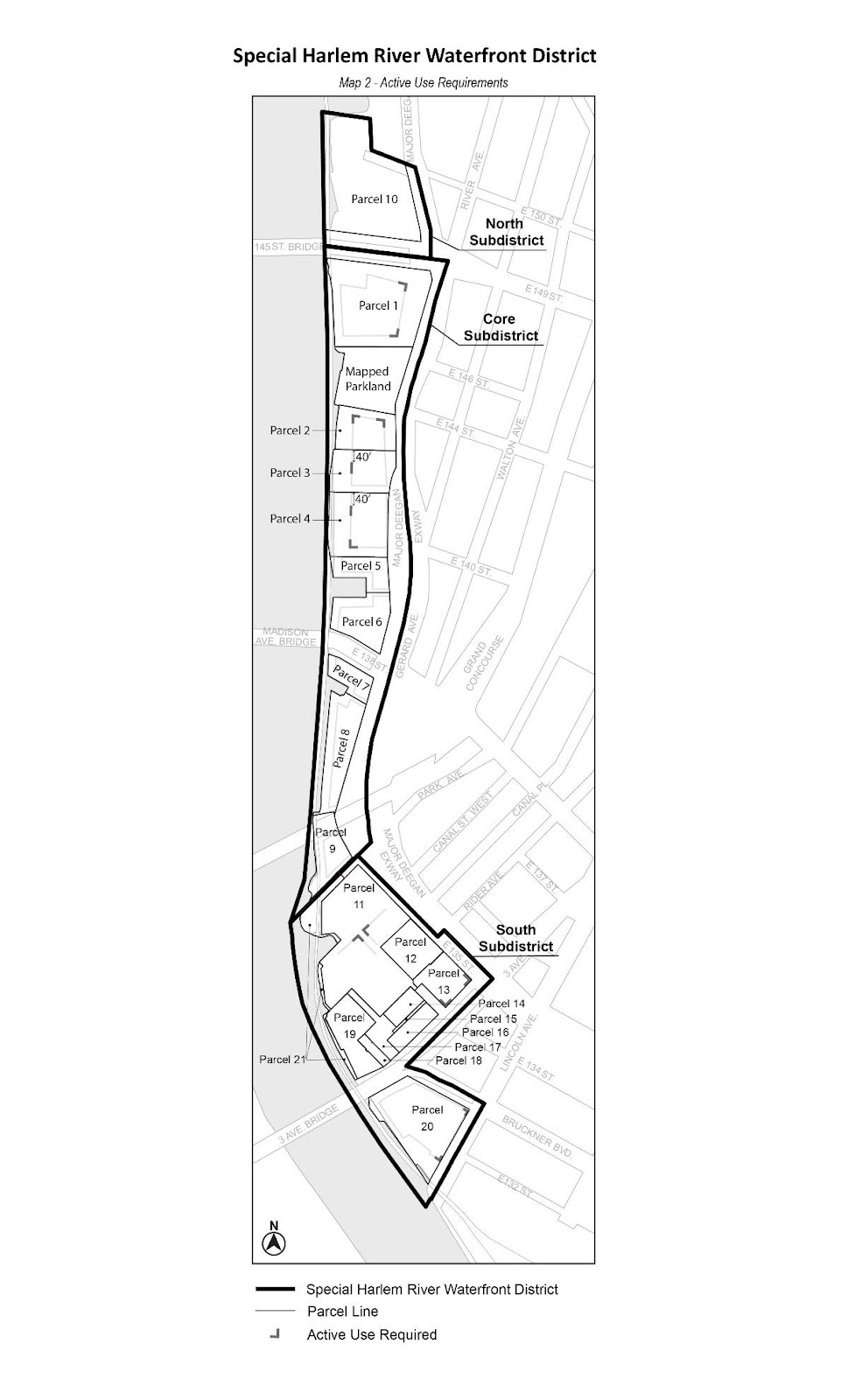
The underlying ground floor level streetscape provisions set forth in Section 32-30 (STREETSCAPE REGULATIONS), inclusive, shall apply, except that ground floor level street frontages locations, in 50-foot increments designated on Map 2 (Designated Non-Residential Use Locations) in the Appendix of this Chapter, shall be considered Tier C street frontages, and all other frontages shall be considered Tier B street frontages.
For the purposes of applying such streetscape regulations, shore public walkways, mapped parkland, supplemental public access areas, upland connections and fire apparatus access roads provided pursuant to the provisions of Section 87-61 (Special Provisions for Certain Fire Apparatus Access Roads), shall be considered streets, and shore public walkways and mapped parkland shall be considered wide streets.
On Parcels 5 and 6, as shown on Map 1 in the Appendix to this Chapter, the width of any ground floor level commercial or community facility establishments facing a shore public walkway or upland connection, shall be limited to 60 feet for each street wall facing such shore public walkway or upland connection.
On Parcels 2, 3 and 4, as shown on Map 1 in the Appendix to this Chapter, a main front entrance for at least one building, as the term “main front entrance” is used in the New York City Fire Code, Section 502.1 (FRONTAGE SPACE), or its successor, shall be located facing the shore public walkway. Such main front entrance of a building shall be:
- on Parcel 2, located no less than 95 feet from a mapped parkland; and
- on Parcels 3 and 4, located no less than 45 feet from an upland connection.
Open Parking Areas
Open parking areas shall be permitted only in the following locations:
- on Parcel 1, as shown on Map 1 in the Appendix to this Chapter, a parking lot shall be permitted east of the Major Deegan Expressway street line;
- on Parcel 5, as shown on Map 1, a parking lot shall be permitted anywhere within the parcel only if a commercial or public utility vehicle storage use, including accessory motor fuel pumps listed under Use Group IX(C), is developed or enlarged as the primary use on the parcel;
- on Parcel 6, a parking lot shall be permitted within 130 feet of the southern boundary of the parcel with East 138th Street; and
- on all parcels, open, unscreened, in tandem (one behind the other), accessory off-street parking spaces shall be permitted on private roads, including fire apparatus access roads provided pursuant to the provisions of Section 87-61 (Special Provisions for Certain Fire Apparatus Access Roads), provided that all parking spaces comply with the Department of Transportation standards for on-street parking.
For such open parking lots, the provisions of paragraph (c) of Section 25-621 (Location of parking spaces in certain districts) shall not apply. In addition, on Parcel 1, for parking lots located east of the Major Deegan Expressway street line, or, on Parcel 5, for parking lots used solely as a commercial or public utility vehicle storage use, including accessory motor fuel pumps listed under Use Group IX(C), the provisions of Sections 37-90 (PARKING LOTS) and 62-655 (Planting and trees) shall be modified to permit fencing, excluding chain link fencing, in lieu of all planting requirements, provided that the surface area of such fencing is not more than 50 percent opaque and provided that the height does not exceed six feet. The provisions of Sections 37-90 and 62-555 shall not apply to any parking lots provided within private roads, including fire apparatus access roads provided pursuant to the provisions of Section 87-61.
- For Parcels 1, 2, 3 and 4, as shown on Map 1 in the Appendix to this Chapter, the open area between the street wall of a building fronting on the Major Deegan Expressway street line and the western edge of such Expressway, shall be subject to the provisions of Section 23-613 (Front yard planting requirements), whether the ground floor is occupied by residential uses or non- residential uses. Such provisions shall be modified by the provisions of this Section.
- Primary circulation path
A circulation path, with a width of at least 13 feet or the width of such open area, whichever is less, and the western edge of such path shall be provided within five feet of a street wall facing the Major Deegan Expressway street line. Such circulation path shall extend along the entire frontage of the zoning lot, and shall be constructed in accordance with Department of Transportation standards for sidewalks. - Planting
At least 20 percent, but not more than 50 percent of the required open area shall be planted with any combination of perennials, annuals, decorative grasses, shrubs or trees in planting beds, raised planting beds or planter boxes. Such planting bed shall extend to a depth of at least three feet, inclusive of any structure containing the planted material, and any individual planted area shall have a width of at least five feet. For planting located east of the circulation path required pursuant to this paragraph (a), the maximum linear length of any individual planting bed shall not exceed 50 feet. - Other amenities
The remainder of the open area may contain any combination of:- streetscape amenities including, but not limited to, benches or tables and chairs;
- entertainment amenities including, but not limited to, water features, playgrounds, dog runs, game tables, courts or skateboard parks; and
- streetscape-enhancing amenities including, but not limited to, trees in tree pits, and lighting, or sculptural artwork.
All streetscape and entertainment amenities provided in accordance with paragraphs (a)(3)(i) and (a)(3)(ii) of this Section shall be connected to the primary circulation path required by paragraph (a) of this Section through secondary circulation paths, paved with permeable materials, each with a minimum width of six feet. Any planting associated with an amenity including, but not limited to, playgrounds and dog runs, as applicable, may exceed the amount set forth in paragraph (b) of this Section.
Any open area not otherwise allocated to amenities or secondary circulation paths shall also be paved with permeable materials. The minimum clear space between any planted areas required by paragraph (b) of this Section, any amenity provided under this paragraph, or any combination thereof, shall be six feet.
- Fencing
In no event shall chain link fencing or barbed or razor wire be permitted in any open area provided pursuant to this Section. No fences may exceed a height of four feet.
- Primary circulation path
- In the event that Parcel 1 is developed with mixed buildings, sidewalks shall be provided on such parcel as follows:
- Sidewalks with a width of at least 15 feet shall be provided along the entire Exterior Street and East 149th Street frontage of a zoning lot.
- In locations where the width of the sidewalk within the street is less than 15 feet, a sidewalk widening shall be provided on the zoning lot such that the combined width of the sidewalk within the street and the sidewalk widening equals at least 15 feet. However, existing buildings remaining on the zoning lot need not be removed in order to comply with this requirement.
All sidewalks and sidewalk widenings shall be constructed or improved to Department of Transportation standards and shall connect at grade to the adjoining public sidewalks.
The applicable parking and loading regulations of underlying districts or of Article VI, Chapter 2 (Special Regulations Applying in the Waterfront Area) shall apply, except as modified by the provisions of this Section, inclusive.
(a) Off-site parking
The off-site parking location provisions of Sections 36-42 and 36-43 shall not apply. In lieu thereof, all permitted or required accessory off-street parking spaces may be provided on any zoning lot within the Core Subdistrict.
(b) Roof parking
Any roof, or portion thereof, that covers off-street parking spaces and is larger than 400 square feet in surface area, shall be landscaped. Up to five percent of such roof area may be used for mechanical equipment, provided that such mechanical equipment is screened from view by a fence which is at least 75 percent opaque or by at least three feet of dense planting. Up to 25 percent of such roof area may be accessible solely from an adjacent dwelling unit and the remaining roof area shall be accessible for the recreational use of the occupants of the building in which it is located. Hard surfaced areas shall not cover more than 60 percent of such roof area.
Curb Cut Restrictions
On Parcels 1, 2, 3 and 4, as shown on Map 1 in the Appendix to this Chapter, no curb cuts shall be provided facing a shore public walkway, and further, on Parcels 1 and 2, no curb cuts shall be provided facing a mapped parkland.
Sidewalks
In the event that Parcel 1, as shown on Map 1 in the Appendix to this Chapter, is developed with mixed use buildings, as defined in Section 123-11, sidewalks shall be provided on Parcel 1, as follows:
(a) Sidewalks with a depth of at least 15 feet, measured perpendicular to the curb of a street, shall be provided along the entire Exterior Street and East 149th Street frontage of a zoning lot. In locations where the width of the sidewalk within the street is less than 15 feet, a sidewalk widening shall be provided on the zoning lot so that the combined width of the sidewalk within the street and the sidewalk widening equals 15 feet. However, existing buildings to remain on the zoning lot need not be removed in order to comply with this requirement.
(b) A 22 foot wide walkway shall extend east of and along the Parcel 1 building line, linking East 149th Street and mapped parkland, or a fire apparatus access road if such road is provided adjacent to mapped parkland. In the event that a parking lot is provided east of such walkway, the easternmost seven feet of such walkway shall be densely planted with evergreen shrubs maintained at a maximum height of three feet above the adjoining walkway. Such walkway and planting strip may be interrupted to allow vehicular or pedestrian access.
(c) Any driveway located east of the Parcel 1 building line that extends along a sewer easement and intersects Exterior Street shall have curbs and sidewalks with a minimum width of 13 feet along each curb, which may be interrupted to allow for vehicular access to a parking lot.
All sidewalks and sidewalk widenings shall be constructed or improved to Department of Transportation standards, shall be at the same level as the adjoining public sidewalks, and shall be accessible to the public at all times.
The provisions of this Section, inclusive, shall apply in the Core Subdistrict, as shown on Map 1 in the Appendix to this Chapter. The lot area allocated to fire apparatus access road pursuant to the provisions of this Section 87-60, inclusive, may count towards any required supplemental access area required pursuant to the provisions of Section 62-57 (Required Supplemental Public Access Areas) and, where applied, such area may be discounted from the planting requirement set forth in paragraph (c) of Section 62-62 (Design Requirements for Shore Public Walkways and Supplemental Public Access Areas).
Within the Core and South Subdistricts, for Parcels 1, 2, 3, 4 and 11, as shown on Map 1 in the Appendix to this Chapter, where a fire apparatus access road is provided as required by New York City Fire Code Section 503.2 (Fire apparatus access roads), or its successor, the Chairperson of the City Planning Commission shall certify, in conjunction with a certification application filed pursuant to paragraph (c) of Section 62-811, the following:
(a) the road shall be constructed to minimum Department of Transportation standards for public streets, including two sidewalks, curbs and curb drops, lighting, signage, materials and crosswalk, and shall meet the requirements set forth in the New York City Fire Code. For Parcels 2, 3 and 4, where a fire apparatus access road is immediately adjacent to and contiguous with the shore public walkway, any pedestrian path within such shore public walkway shall substitute for one such sidewalk, provided that at least 30 percent of such path is provided adjacent to and contiguous with the fire apparatus access road;
(b) for Parcels 2, 3 and 4, the contiguity provisions of paragraph (a) of Section 87-62 shall apply, except that where no connection for vehicular travel lanes terminating at the opposite side of a shared lot line exist at the time of construction, the provisions of paragraph (b) of such Section may be utilized as an interim alternative;
(c) a restrictive declaration shall be executed in accordance with the provisions of Section 87-63; and
(d) street trees shall be planted pursuant to the requirements of Section 26-41 along such fire apparatus access road as if it were a street.
However, the requirements of this Section shall not apply to: fire apparatus access roads on Parcels 1 and 3 that are provided pursuant to the provisions of paragraph (b)(3) of Section 87-71 (Special Public Access Provisions); and to a fire apparatus access road on Parcel 11 located in the required upland connection within the prolongation of East 134th Street.
On Parcels 2, 3 and 4, as shown on Map 1 in the Appendix to this Chapter, in addition to the certification provisions of Section 87-61 (Special Provisions for Certain Fire Apparatus Access Roads), a fire apparatus access road shall be provided in accordance with the provisions of this Section.
(a) Bi-Directional Road
On each of Parcels 2, 3 and 4, and only between such parcels, a connection for bi-directional vehicular travel lanes to an adjacent zoning lot line shall be provided. When complete, such fire apparatus access road shall provide bi-directional contiguous vehicular access from the intersection of Exterior Street and the northern boundary of Parcel 2, immediately adjacent to and contiguous with the entire southern boundary of the mapped parkland immediately adjacent to Parcel 2, immediately adjacent to and contiguous with the shore public walkway of Parcels 2, 3 and 4, to within the southerly upland connection of Parcel 4.
Any connection of fire apparatus access roads across a shared zoning lot line must meet the grade of, and maintain the street width of, the existing adjacent fire apparatus access road. Such fire apparatus access road shall extend immediately adjacent to and contiguous with the entire shore public walkway of the zoning lot, from lot line to lot line. A connection need not be opened unless and until such declaration of restrictions, in accordance with Section 87-63, has been recorded against the adjacent zoning lot.
(b) Interim fire apparatus access road turnaround
When bi-directional vehicular travel lanes are constructed that terminate at a lot line and do not continue on the adjacent zoning lot at the time of their construction, an interim dead-end fire apparatus access road turnaround may be constructed as an alternative to the provisions of paragraph (a) of this Section, in accordance with the following provisions.
An applicant utilizing the provisions of this paragraph shall construct a fire apparatus access road that extends along the entire southern boundary of mapped parkland immediately adjacent to Parcel 2, the entire upland connection and the entire shore public walkway of the zoning lot, as applicable, from lot line to lot line, and shall provide an “approved turnaround area,” constructed as part of a “dead-end fire apparatus access road,” as those terms are defined in the New York City Fire Code, Section 503.2.9 (Dead-end turnarounds), or its successor.
Such turnaround area shall be constructed to dimensions no greater than required under the New York City Fire Code, Section 503.2.9, or its successor, and shall be located at the end of the fire apparatus access road, abutting the adjacent lot line. Such turnaround area may extend into the designated shore public walkway, but at no point may such turnaround area extend into the associated circulation path. Where an interim dead-end fire apparatus access road turnaround area extends into the shore public walkway, the area of such turnaround may be discounted from the planting requirement set forth in paragraph (c) of Section 62-62. Sidewalks shall not be required adjacent to the turnaround area. The portion of the turnaround area that lies within a shore public walkway shall remain clear of obstacles, shall be composed of permeable materials to the extent permissible by the Fire Commissioner and shall meet all applicable requirements set forth in the New York City Fire Code, Section 503.2 (Fire apparatus access roads), or its successor. In addition, the roadbed material of a fire apparatus access road leading to a turnaround may be extended into the turnaround provided the area of the turnaround paved with such material is not wider than the roadbed leading to the turnaround. The remaining portions of the turnaround shall be paved with distinct materials to facilitate pedestrian usage.
At the time of certification pursuant to Section 87-61, the site plan shall demonstrate a suitable design for the dead-end fire apparatus access road that demonstrates both the approved turnaround area and the repurposed turnaround area outside of the roadbed upon the issuance of a notice of substantial compliance for the adjacent zoning lot. In addition, a conceptual site plan shall demonstrate that the proposed site plan and grading plan for required contiguous access pursuant to the provisions of paragraph (a) of this Section is compatible with future development on the adjoining zoning lot. Such site plans shall be included as an exhibit to the declaration of restrictions recorded pursuant to Section 87-63.
Repurposing a turnaround area and providing contiguous access in accordance with an approved conceptual site plan shall not necessitate a certification pursuant to Section 62-811, provided that there are no further modifications to an approved waterfront public access area.
For any fire apparatus access road proposed for certification pursuant to Section 87-61 (Special Provisions for Certain Fire Apparatus Access Roads), a declaration of restrictions shall be provided to guarantee the construction, improvement, operation, maintenance and repair of such road, and any sidewalk adjacent to such road, to guarantee that such road, and any sidewalk adjacent to such road, remains open, unobstructed and accessible to all members of the public, except as necessary to avoid public dedication, and to ensure compliance with all applicable provisions. Such declaration of restrictions shall be prepared in a form acceptable to the Department of City Planning, shall be filed and duly recorded in the Borough Office of the Register of the City of New York and indexed against the property. Filing and recording of the declaration of restrictions shall be a precondition for the Chairperson’s certification under Section 87-61, where applicable.
For certifications proposed pursuant to Section 87-61 on Parcels 2, 3 or 4, where developments or enlargements on such parcels utilize the allowance for interim fire access turnaround, in accordance with paragraph (b) of Section 87-62 (Contiguity of Fire Apparatus Access Road with Adjacent Zoning Lots on Parcels 2, 3 and 4), any declaration of restrictions shall include that, at the time of the issuance of the notice of substantial compliance for the adjacent development, or enlargement pursuant to this Section, thereby permitting vehicular connection between zoning lots, the zoning lot containing a previously constructed fire apparatus access road turnaround area shall be responsible for the following actions on the portion of the connection on such zoning lot:
(a) repurposing the fire apparatus access road turnaround area pursuant to the requirements set forth in paragraph (b) of Section 87-62;
(b) extending all required sidewalks that had remained short of the lot line to the shared lot line to connect to the required adjacent sidewalks and enable unobstructed pedestrian movement across parcels;
(c) complying with all applicable waterfront rules, the Department of Transportation standards for public streets and the New York City Fire Code; and
(d) providing a connection with the adjacent zoning lot pursuant to Section 87-62.
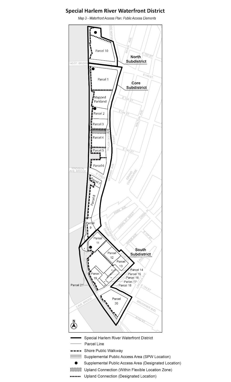
Map 3 (Waterfront Access Plan: Public Access Elements) in the Appendix to this Chapter shows the boundaries of the area comprising the Harlem River Waterfront Access Plan and the location where certain features are mandated or permitted by the Plan.
The underlying regulations for waterfront public access areas shall apply, except as modified in this Section, inclusive. For the purposes of applying the provisions of Section 61-822, the City Planning Commission may authorize modifications to the requirements for waterfront public access areas set forth in Article VI, Chapter 2 (Special Regulations Applying in the Waterfront Area), and as those provisions are modified by the provisions of this Section, inclusive.
The provisions of Section 62-50 (GENERAL REQUIREMENTS FOR VISUAL CORRIDORS AND WATERFRONT PUBLIC ACCESS AREAS) shall apply to developments, as modified in this Section. For the purpose of this Section, “development” shall be as defined in Section 62-11. To “develop” shall mean to create such development. In addition, the lot area allocated to fire apparatus access road pursuant to the provisions of Section 87-60, inclusive, may count towards any required supplemental access area required pursuant to the provisions of Section 62-57 (Required Supplemental Public Access Areas).
(a) Shore public walkways
(1) The shore public walkway shall be provided in the location designated on Map 3 (Waterfront Access Plan: Public Access Elements) and constructed at an elevation not lower than the highest level of the train track bed of the Oak Point Rail Link, except that on Parcel 5, if commercial or public utility vehicle storage, as listed in Use Group 16C, is developed as the primary use on the zoning lots, the elevation requirement shall not apply. However, for any other use, the elevation requirement shall only apply along the westernmost section of the shore public walkway to a depth of 40 feet.
(2) An approved turnaround area in a dead-end fire apparatus access road, as defined in the New York City Fire Code, Section 503.2.9 (Dead-end turnarounds), or its successor, may, by certification extend into a designated shore public walkway pursuant to paragraph (b) of Section 87-62 (Contiguity of Fire Apparatus Access Road with Adjacent Zoning Lots on Parcels 2, 3 and 4).
(3) In the event that a portion of a waterfront zoning lot is within 40 feet of the shoreline yet does not abut the shoreline because of an intervening zoning lot, a shore public walkway shall be provided on such upland portion. The width of the shore public walkway on such portion shall be 40 feet measured from the shoreline of the intervening zoning lot and shall include the width of the intervening zoning lot. The portion of such shore public walkway located upland of the intervening zoning lot shall be improved with a circulation path at least 10 feet wide, and any required planted screening buffer shall have a width of at least four feet.
(4) On Parcel 5, if a commercial or public utility vehicle storage use is developed as the primary use on the parcel, the shore public walkway requirements set forth in Section 62-62 shall apply, except that:
(i) the required width of the shore public walkway may be reduced to a minimum of 20 feet along the northern edge of the inlet and may be reduced to a minimum of 30 feet along the eastern edge of the inlet;
(ii) the circulation path required in paragraph (a)(1) of Section 62-62 shall be modified to a minimum width of 10 feet along the northern and eastern edge of the inlet;
(iii) the screening provisions of paragraph (c)(2) of Section 62-62 shall not apply. In lieu thereof, a planted screening buffer with a width of four feet shall be provided. Such planted buffer shall consist of densely planted shrubs or multi-stemmed screening plants, with at least 50 percent being evergreen species. Shrubs shall have a height of at least four feet at the time of planting; and
(iv) a 10-foot-wide pedestrian walkway between the shore public walkway and Exterior Street shall be provided on Parcel 5 adjacent to such upland connection location.
(b) Upland connections
Upland connections shall be located on Parcels 1, 3, 4, 5, 6, 10 and 11, as designated on Map 3 in the Appendix to this Chapter. The applicable provisions of Section 62-50, inclusive, are modified, as follows:
(1) On Parcel 1, for an upland connection required along the northern boundary of a mapped park, the additional open area requirement of paragraph (a)(2) of Section 62-561 (Types of upland connections) shall not apply;
(2) Parcel 3 shall provide an upland connection at the designated location shown on Map 3. In addition, such upland connection shall be provided as specified below:
(i) The additional area requirements of paragraph (a)(2) of Section 62-561 shall not apply.
(ii) In the event that Parcel 3 is developed with Parcels 2 or 4, an upland connection shall be provided within the flexible location zone shown on Map 3. The additional area requirements of paragraph (a)(2) of Section 62-561 shall apply.
(3) On Parcels 1 and 3, if a Type 1 upland connection is provided, and a fire apparatus access road is required pursuant to the New York City Fire Code, Section 503.2 (Fire apparatus access roads), or its successor, the design requirements of Section 62-64 shall be modified as follows:
(i) the required circulation path may be used to allow such fire apparatus access road, and its minimum width shall be in accordance with all applicable requirements of the Fire Code;
(ii) such circulation path shall be paved with distinct materials, not including asphalt, to facilitate pedestrian usage; and
(iii) the minimum planting area requirements shall be reduced to 15 percent;
(4) The required width for an upland connection on Parcel 6 is reduced to 12 feet. Such upland connection shall be subject only to the applicable pedestrian path provisions.
(c) Supplemental public access areas
Supplemental public access areas, pursuant to this Plan, shall be provided on Parcels 1, 2, 10 and 11, as indicated on Map 3 in the Appendix to this Chapter, except that:
(1) such requirement may be waived for Parcels 1 and 2 by the Chairperson of the City Planning Commission, in conjunction with a certification pursuant to paragraph (c) of Section 62-811 (Waterfront public access and visual corridors), where the site plan includes a vehicular connection through the zoning lot, provided that:
(i) such vehicular connection complies with the requirements of Section 87- 62 (Fire Apparatus Access Roads) and, for Parcel 2, the requirements of Section 87-62 (Contiguity of Fire Apparatus Access Road With Adjacent Zoning Lots on Parcels 2, 3 and 4); and
(ii) such vehicular connection, either:
(a) on Parcel 1, provides access between East 149th Street and Exterior Street, serving all buildings along the shore public walkway and mapped parkland; or
(b) on Parcel 2, provides a bi-directional connection from the intersection of Exterior Street and the northern boundary of Parcel 2, immediately adjacent to and contiguous with the entire southern boundary of the mapped parkland, immediately adjacent to and contiguous with the shore public walkway to the southernmost lot line of Parcel 2.
(2) for Parcel 11, at the location designated as “Supplemental Public Access Area (Shore Public Walkway Location)” on Map 3, a supplemental public access area shall be provided at a minimum width of 40 feet as indicated on Map 3, and the design and dimensional requirements for shore public walkway as set forth in Sections 62-50, inclusive, and 62-60, inclusive, shall apply.
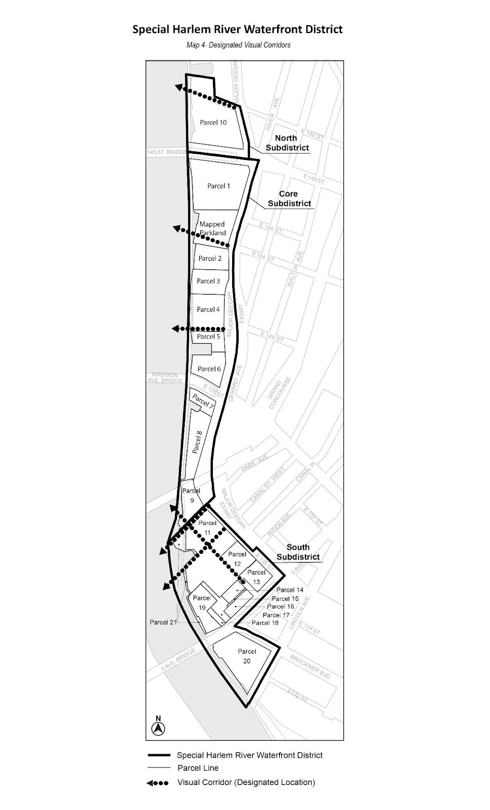
(d) Visual Corridors
Visual corridors shall be located within Parcels 4, 9, 10, 11, 12 and 13, and mapped parkland, as indicated on Map 4 (Waterfront Access Plan: Visual Corridors) in the Appendix to this Chapter. For all required visual corridors, the provisions of Section 62-512 (Dimension of visual corridors) shall be modified to allow the lowest level of a visual corridor, at its seaward points, to be measured to a height as set forth in Section 62-512 or a height equal to the Oak Point Rail Link train track bed elevation, whichever is higher.
The Oak Point Rail Link shall be a permitted obstruction for visual corridors.
In the event that streets are mapped within a zoning lot on Parcels 1, 2, 3 or 4 after June 30, 2009, or on Parcel 11 after December 11, 2017, the area within such streets may continue to be considered part of the zoning lot for the purposes of applying all waterfront regulations of the Zoning Resolution.
In the South Subdistrict, as shown on Map 1 in the Appendix to this Chapter, the provisions of Section 11-30 (BUILDING PERMITS ISSUED BEFORE EFFECTIVE DATE OF AMENDMENT), inclusive, shall apply, except as modified by the provisions of this Section. For the purpose of this Section, development shall be as defined in Section 62-11.
(a) For Parcel 20, a building permit may be issued in accordance with the bulk and waterfront public access area regulations that were effective immediately prior to December 11, 2017, where, as part of an application filed with the Department of City Planning for certification pursuant to the provisions of Section 62-811 prior to December 11, 2017, a declaration of restrictions has been recorded with the Office of the Register of the City of New York (County of the Bronx), setting forth the obligations of the owner to construct, and maintain a waterfront public access area pursuant to the provisions of Section 62-811. Such building permit shall allow the development of a building only in accordance with such certified waterfront public access area plan.
(b) For Parcel 19, a building permit may be issued in accordance with the bulk and waterfront public access area regulations that were effective immediately prior to December 11, 2017, where the Chairperson has certified that no waterfront public access area is required on the zoning lot pursuant to the provisions of Section 62-811 prior to December 11, 2017, provided that no new buildings or other structures, except those permitted as obstructions pursuant to Section 62-611, are located within 40 feet of the shoreline, and further provided that all work on the foundations for such development has been completed prior to December 11, 2021.
In addition, for such development, no temporary certificate of occupancy shall be granted by the Department of Buildings unless and until the Chairperson of the City Planning Commission certifies that the zoning lot provides open space between the building and the shoreline that is in compliance with the size and design provisions for shore public walkways set forth in Section 62-53 and the provisions of Section 62-60, inclusive. However, such provisions may be modified as follows:
(1) in addition to the permitted obstructions listed in Section 62-611, a dead-end fire apparatus access road turnaround shall be permitted obstruction within a shore public walkway, and an emergency egress path from buildings shall be a permitted obstruction within a screening buffer;
(2) for portions of the shore public walkway where a fire apparatus access road turnaround is provided, the minimum width of a circulation path required pursuant to paragraph (a)(1) of Section 62-62 (Design Requirements for Shore Public Walkways and Supplemental Public Access Areas) may be reduced to a width of 10 feet, and the required width of a screening buffer required pursuant to paragraph (c)(2) of Section 62-62, may be reduced to six feet; and
(3) where a fire apparatus access road is provided within the shore public walkway, the percentage of the shore public walkway required to be planted pursuant to paragraph (c) of Section 62-62 may be reduced to 35 percent.
As part of an application for certification pursuant to this paragraph, a site plan shall be submitted, along with any other materials necessary to demonstrate compliance with the provisions of this paragraph (b).
All open space certified pursuant to the provisions of this paragraph shall comply with the maintenance and operation requirements of Sections 62-71 and 62-72.
In addition, a written declaration of restrictions shall be recorded against such property in the Office of the Register of the City of New York (County of the Bronx) pursuant to the provisions of Section 62-74 (Requirements for Recordation), setting forth obligations of the owner to construct, maintain and provide public access to improvements certified by the Chairperson pursuant to this paragraph. Proof of recordation of the declaration of restrictions shall be submitted in a form acceptable to the Department of City Planning.
In the event that foundations required to be completed prior to December 11, 2021, have been commenced but not completed before such date, the building permit shall automatically lapse and the right to continue construction under the provisions of this Section shall terminate. No application to renew the building permit may be made to the Board of Standards and Appeals.
Where foundations have been completed prior to December 11, 2021, the provisions of Section 11-332 (Extension of period to complete construction) may be utilized and such date shall be the effective date for applying such provisions.
Appendix
Special Harlem River Waterfront District Plan
(12/11/17)
Map 1. Special Harlem River Waterfront District, Subdistricts and Parcels (87-A1)
Map 2. Designated Non-residential Use Locations (87-A2)
Map 3. Waterfront Access Plan: Public Access Elements (87-A3)
Map 4. Waterfront Access Plan: Visual Corridors (87-A4)