Chapter 6 - Special Stapleton Waterfront District (SW)
GENERAL PURPOSES
The "Special Stapleton Waterfront District" established in this Resolution is designed to promote and protect public health, safety and general welfare. These general goals include among others, the following specific purposes:
(a) encourage design of development that is in character with the neighborhood and surrounding community;
(b) maintain and reestablish physical and visual public access to and along the waterfront;
(c) strengthen the traditional town center of Stapleton by allowing the development of residential and commercial uses;
(d) encourage the creation of a lively and attractive environment that will provide daily amenities and services for the use and enjoyment of the working population and the new residents;
(e) take maximum advantage of the beauty of the New York Harbor waterfront, thereby best serving the business community, the residential population and providing regional recreation; and
(f) promote the most desirable use of land and thus conserve and enhance the value of land and buildings, and thereby protect City tax revenues.
Definitions
For the purposes of this Chapter, matter in italics is defined in Sections 12-10 (DEFINITIONS), 32-301 (Definitions), or in this Section.
Esplanade
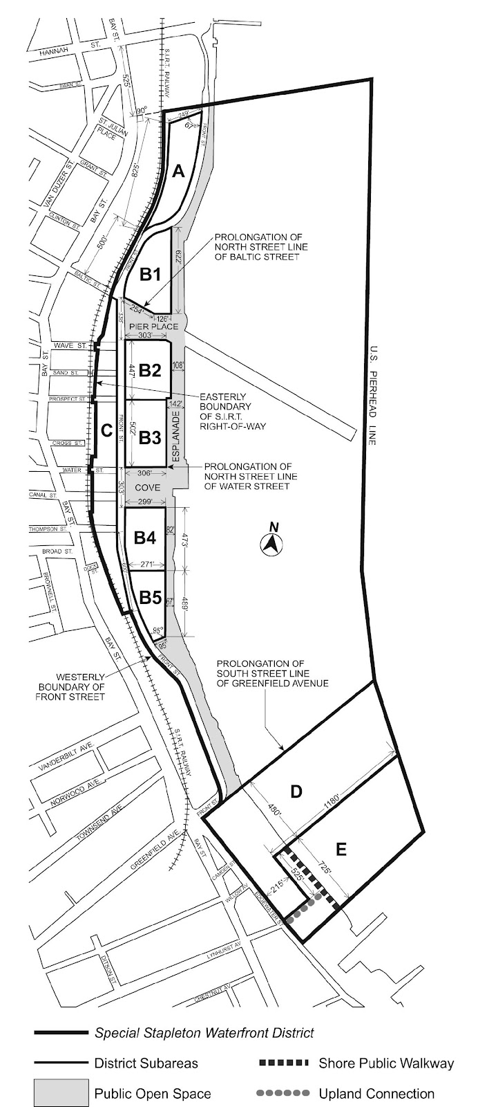
The "Esplanade" is a park extending along portions of the waterfront edges of the Special Stapleton Waterfront District. The Esplanade is shown in the District Plan, Map 1 (Special Stapleton Waterfront District, Subareas and Public Spaces), in Appendix A of this Chapter.
Mandatory front building wall
A "mandatory front building wall" is the front wall of a building that generally coincides with a mandatory front building wall line, as provided in Section 116-232 (Street wall location).
Mandatory front building wall line
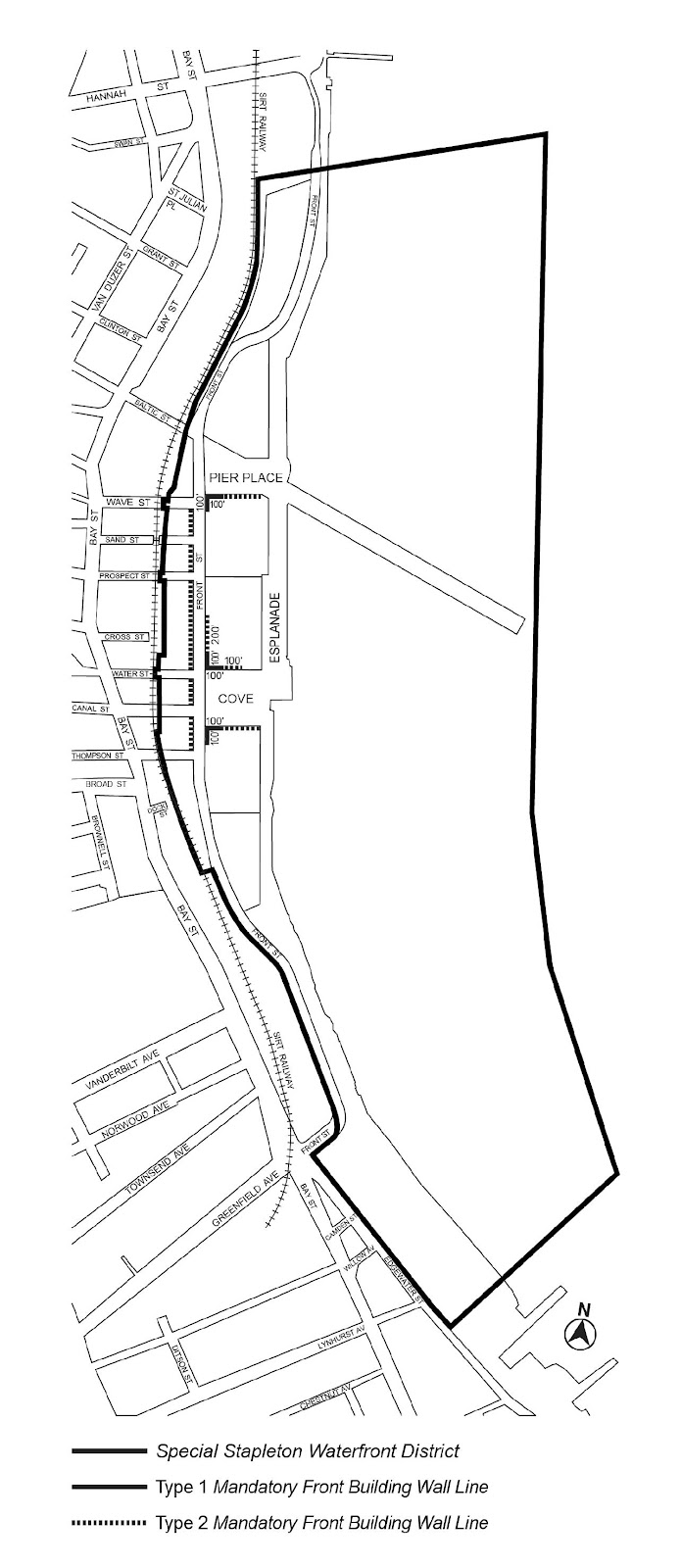
"Mandatory front building wall lines" are imaginary lines extending through Subarea B of the Special Stapleton Waterfront District which are shown on Map 3 (Mandatory Front Building Wall Lines) in Appendix A of this Chapter, and with which building walls must generally coincide, as provided in Section 116-232.
Pier Place, the Cove
"Pier Place" and the "Cove" are designated open spaces accessible to the public, located within the Special Stapleton Waterfront District as shown in the District Plan, Map 1, in Appendix A of this Chapter.
Shore public walkway
A "shore public walkway" is a linear public access area along the shore or water edges of a platform on a waterfront zoning lot.
Upland connection
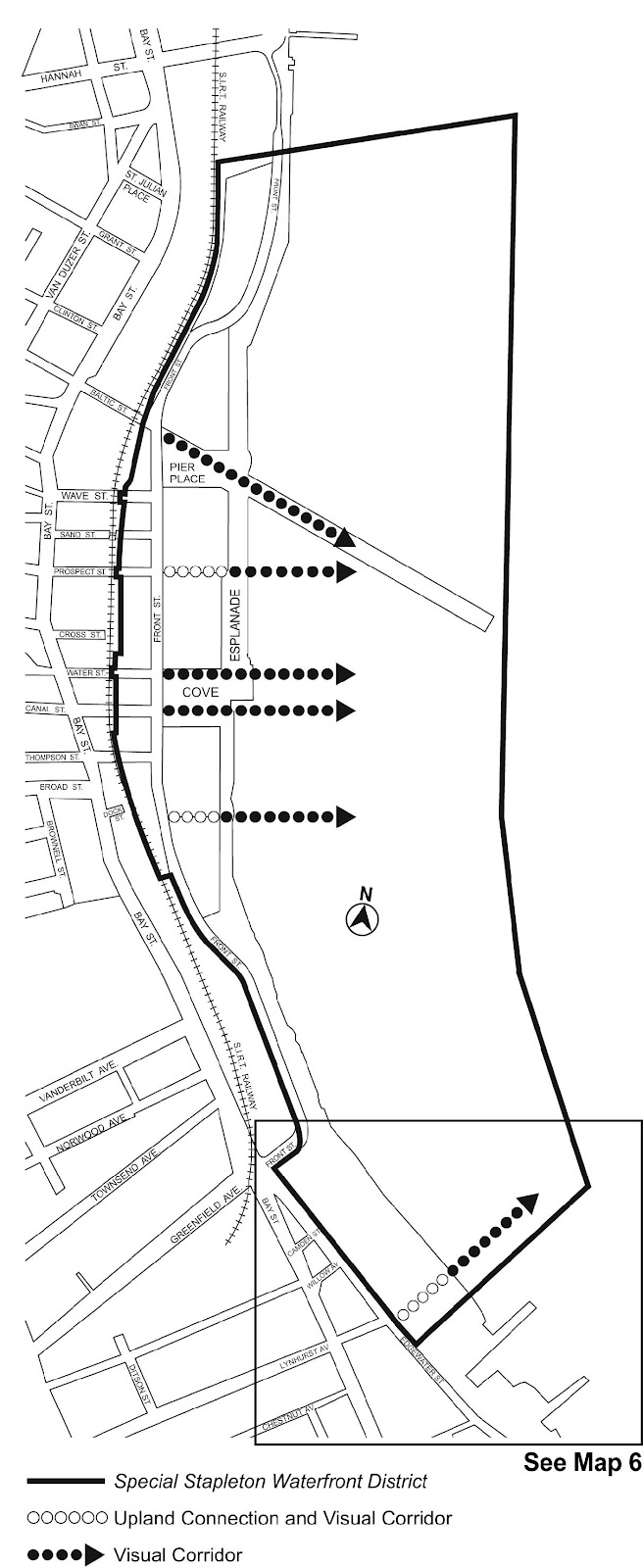
An "upland connection" is a pedestrian way which provides a public access route from the Esplanade or a shore public walkway to a public sidewalk within a public street. Required upland connections are shown in the District Plan, Map 5 (Upland Connections and Visual Corridors), in Appendix A of this Chapter
Visual corridor
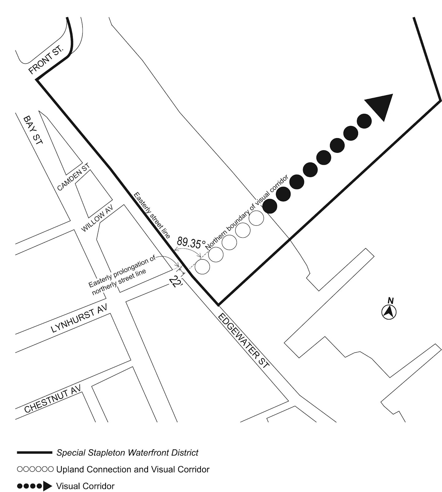
A "visual corridor" is a public street or tract of land within a block that provides a direct and unobstructed view to the water from a vantage point within a public street. Required visual corridors are shown in the District Plan, Map 5 and Map 6 (Location of Visual Corridor in Subarea E) in Appendix A of this Chapter.
General Provisions
In harmony with the general purposes and content of this Resolution and the general purposes of the Special Stapleton Waterfront District, the provisions of this Chapter shall apply to all developments, enlargements and changes of use within the Special Stapleton Waterfront District. The regulations of all other Chapters of this Resolution are applicable except as modified, supplemented or superseded by the provisions of this Chapter. In the event of a conflict between the provisions of this Chapter and other regulations of this Resolution, the provisions of this Chapter shall control. However, in flood zones, or for transit-adjacent sites, as defined in Section 66-11 (Definitions), in the event of a conflict between the provisions of this Chapter and the provisions of Article VI, Chapter 4 (Special Regulations Applying in Flood Hazard Areas), or Article VI, Chapter 6 (Special Regulations Applying Around Mass Transit Stations), the provisions of Article VI shall control.
Within the Special Stapleton Waterfront District, the regulations of the underlying R6, C2-2, C4-2A and M2-1 Districts shall apply, as modified in this Chapter.
District Plan
The District Plan for the Special Stapleton Waterfront District identifies specific areas comprising the Special District in which special zoning regulations are established in order to carry out the general purposes of the Special Stapleton Waterfront District.
These areas shall include Subareas A, B1, B2, B3, B4, B5, C, D and E, the Esplanade and two designated public open spaces: Pier Place and the Cove. In addition, Subareas B and E shall include upland connections and Subarea E shall include a shore public walkway.
The District Plan includes the following maps in Appendix A of this Chapter.
Map 1 Special Stapleton Waterfront District, Subareas and Public Spaces
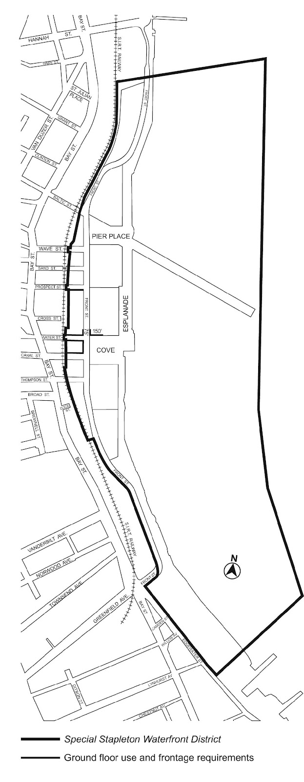
Map 2 Ground Floor Use and Frontage Requirements
Map 3 Mandatory Front Building Wall Lines
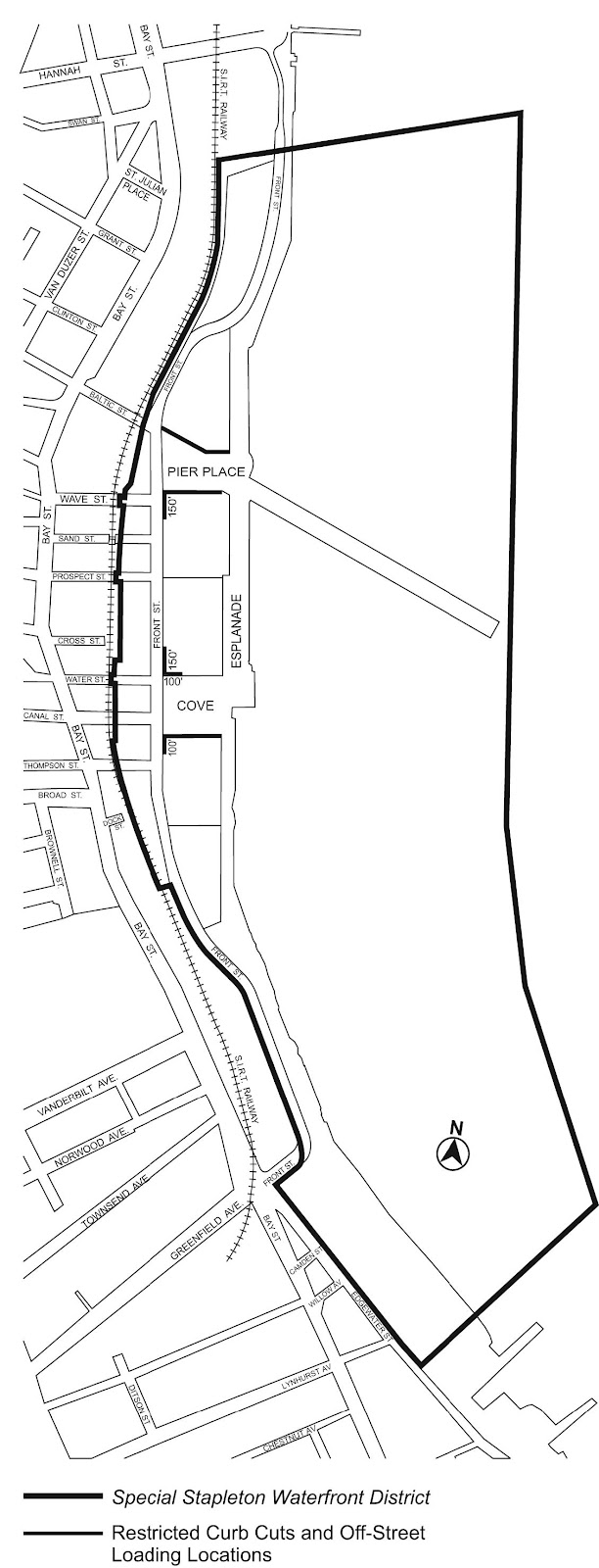
Map 4 Restricted Curb Cut and Off-Street Loading Locations
Map 5 Upland Connections and Visual Corridors
Map 6 Location of Visual Corridor in Subarea E
The maps are hereby incorporated and made part of this Resolution for the purpose of specifying locations where the special regulations and requirements set forth in the text of this Chapter shall apply.
Subareas
In order to carry out the purposes and provisions of this Chapter, the following subareas are established within the Special Stapleton Waterfront District: Subarea A, Subarea B, comprised of Subareas B1, B2, B3, B4 and B5, Subareas C, D and E, the Esplanade, Pier Place and the Cove. In each of these subareas, special regulations apply that may not apply in other subareas.
Applicability
In Subareas A, B and C, the Esplanade, Pier Place and the Cove, the provisions of Article VI, Chapter 2 (Special Regulations Applying in the Waterfront Area), shall not apply. In lieu thereof, the special use, bulk, accessory off-street parking, public access and urban design regulations of Sections 116-10 through 116-50 shall apply.
In Subarea D, the provisions of Article VI, Chapter 2 shall apply pursuant to the underlying M2-1 District regulations.
In Subarea E, the underlying provisions of Article VI, Chapter 2 shall apply, except as modified in Section 116-60 (SPECIAL REGULATIONS IN SUBAREA E), inclusive. In addition, the provisions of Article VI, Chapter 4 (Special Regulations Applying in Flood Zones), shall not apply. In lieu thereof, the provisions of Section 116-623 (Height and setback regulations), shall apply.
Lower density growth management area regulations shall not apply in the Special Stapleton Waterfront District.
In Subareas A, B and C, the Esplanade, Pier Place and the Cove, the underlying use regulations shall be modified by the provisions of this Section, inclusive.
Streetscape Regulations
The underlying ground floor level streetscape provisions set forth in Section 32-30 (STREETSCAPE REGULATIONS), inclusive, shall apply except that:
- ground floor level street frontages along streets, or portions thereof, designated on Map 2 (Ground Floor Use and Frontage Requirements) in Appendix A of this Chapter shall be considered Tier C street frontages; and
- remaining ground floor level street frontages shall be considered Tier B street frontages. However, in lieu of the parking wrap and enclosure provisions of Section 32-32, inclusive, the provisions for Tier A street frontages set forth in Section 32-312 (Ground floor level parking restrictions) may be applied. Notwithstanding the above, in Subarea B5, parking may be located between the street wall of the building and the Front Street street line.
Location of Uses
In addition, the provisions of paragraph (d) of Section 32-422 (Location of floors occupied by commercial uses) shall be modified such that eating or drinking establishments listed under Use Group VI shall be permitted on a story above dwelling units.
Special Sign Regulations
The sign regulations of the underlying C4-2 District in Section 32-60 (Sign Regulations) shall be modified as follows: flashing signs shall not be permitted in Subareas A, B and C, the Esplanade, Pier Place and the Cove.
The special bulk regulations of Section 116-20, inclusive, shall apply to Subareas A, B and C, the Esplanade, Pier Place and the Cove.
Maximum Floor Area Ratio
The maximum floor area ratio for all uses shall be 2.0. However, for zoning lots containing qualifying affordable housing or qualifying senior housing, the maximum residential floor area ratio shall be 2.40.
Additionally, for zoning lots in Subareas A and B1, up to a total of 100,000 square feet of floor space, within a public school, constructed in whole or in part pursuant to an agreement with the New York City School Construction Authority and subject to the jurisdiction of the Department of Education, shall be exempt from the definition of floor area. Zoning lots within Subarea A and B1 that are contiguous or would be contiguous but for their separation by a street, may be considered one zoning lot for the purpose of applying these special floor area regulations.
For buildings containing residences, the area in such buildings occupied by non-residential uses on the ground floor, or within two feet of the as-built level of the adjoining sidewalk, shall be excluded from the calculation of permitted floor area in the building. However, the area occupied by non-residential uses on the ground floor shall be included as floor area for other purposes including calculating:
(a) requirements for accessory off-street parking spaces;
(b) accessory off-street loading berths;
(c) limitations on floor area occupied by certain uses; and
(d) satisfying requirements for FRESH food stores as defined in Article VI, Chapter 3, and the special floor area regulations of that Chapter.
The special height and setback regulations set forth in this Section shall apply.
Special rooftop regulations
The provisions of Section 35-61 (Permitted Obstructions) shall apply to all buildings or other structures in Subareas A, B and C.
Street wall location
Within Subareas A and B, the underlying street wall location regulations shall be modified as follows:
- Subareas A and B1
The street wall location provisions of paragraph (c) of Section 35-631 (Street wall location) shall apply, irrespective of lot area of the zoning lot, and extend up to base heights as specified in Section 116-233 (Height and setback) or the height of the building, whichever is less. - Subareas B2 through B5
- The street wall location provisions of paragraph (a) Section 35-631 shall apply to all street frontages designated as type 1 mandatory front building line on Map 3 (Mandatory Front Building Wall Lines) in Appendix A of this Chapter.
- The street wall location provisions of paragraph (b) Section 35-631 shall apply to all street frontages designated as type 2 mandatory front building line on Map 3 (Mandatory Front Building Wall Lines) in Appendix A of this Chapter.
All mandatory front building walls shall extend up to base heights as specified in Section 116-233 or the height of the building, whichever is less.
Height and setback
Within Subareas A, B and C, the underlying height and setback regulations shall be modified as follows:
(a) Subareas A and B1
(1) Base heights and maximum building heights
The table below sets forth the minimum and maximum base height, the maximum transition height, the maximum height of a building or other structure, and the maximum number of stories for buildings in Subareas A and B1. The maximum building height set forth in the table shall only be permitted in locations where the maximum street wall width of a building above the transition height, or, where applicable, the maximum base height, does not exceed 100 feet. At least 60 feet of separation shall exist between any portions of buildings located above such maximum transition height, or maximum base height, as applicable.
A setback is required for all portions of buildings or other structures that exceed the maximum base height specified for the Subarea, and shall be provided in accordance with paragraph (a)(2) of this Section.
Maximum Base Heights and Maximum Building Heights for Subareas A and B1
|
Minimum Base Height (in feet) |
Maximum Base Height (in feet) |
Maximum Transition Height (in feet) |
Maximum Height of Buildings or Other Structures in Certain Locations (in feet) |
|
40 |
65 |
85 |
125 |
(2) Required setbacks
At a height not lower than the minimum base height, or higher than the maximum base height specified for the Subarea in the table in paragraph (a)(1) of this Section, a setback shall be provided in accordance with the provisions of Section 23-433 (Standard setback regulations).
(b) Subarea B2
Within Subarea B2, the maximum height of a building or other structure shall not exceed 65 feet.
(c) Subareas B3 through B5 and Subarea C
In Subareas B3 through B5 and Subarea C the height and setback regulations applicable to an R6B District set forth in Section 23-43, inclusive, shall apply. For the purposes of applying the setback regulations of Section 23-433, all surrounding streets shall be considered wide streets.
In Subareas A, B and C, the parking and loading regulations of the underlying C4-2A District shall apply, except as modified in this Section.
Waivers of parking requirements for commercial or community facility uses shall only apply to zoning lots existing both on October 25, 2006, and on the date of application for a building permit.
Curb cuts are prohibited in the locations shown on Map 4 (Restricted Curb Cut and Off-Street Loading Locations) in Appendix A of this Chapter.
In Subarea C, for zoning lots with access only to Front Street, only one curb cut shall be permitted along Front Street.
In Subareas A, B and C, the maximum width of curb cuts shall not exceed 25 feet, including splays.
The provisions of this Section shall apply to any new or enlarged open off-street parking facility with ten spaces or more, except where the provisions of Section 37-90 (PARKING LOTS), inclusive, apply.
(a) Screening
Such off-street parking facilities shall be screened, in accordance with the provisions of this Section, from all adjoining zoning lots, including such zoning lots situated across a street, and from any designated open space accessible to the public situated on the same zoning lot, including the Esplanade.
Such screening shall consist of a strip at least four feet wide, densely planted with evergreen shrubs at least four feet high at the time of planting and which are of a type which may be expected to form a year–round dense screen at least six feet high within three years.
Accessory parking spaces that front upon a street shall be screened by a strip at least four feet wide and densely planted with evergreen shrubs to be maintained at all times at a height not less than two and one-half feet and not more than four feet.
In addition, a wall or barrier or uniformly-painted fence of fire-resistant material at least four feet high but not more than eight feet above finished grade may be provided. Such wall, barrier or fence must be 100 percent opaque up to a height of four feet above the finished grade of the parking facility and not more than 35 percent opaque above four feet. No chain link fences shall be permitted. All permitted fences shall be located behind landscaped areas when viewed from the street.
Such screening shall be maintained in good condition at all times, may be interrupted by normal entrances or exits, and shall have no signs hung or attached thereto other than those permitted in Sections 32-60, inclusive, or 62-654.
(b) Tree planting requirements
Trees, pre-existing or newly-planted, shall be provided at the rate of one tree for every eight open parking spaces within the off-street parking facility and may be located on the perimeter of the parking facility or in planting islands within the parking area. For parking facilities with more than 25 open parking spaces, at least 30 percent of trees provided to meet this requirement shall be located in planting islands within the parking area. Trees shall be planted in accordance with the requirements of the Department of Parks and Recreation.
Upland Connections
In the locations shown on Map 5 (Upland Connections and Visual Corridors) in Appendix A of this Chapter, upland connections shall be provided. An upland connection traversing a zoning lot in Subareas A, B and C shall consist of a single circulation path bordered continuously along both sides by buffer zones.
(a) Required dimensions
The minimum width of the upland connection shall be 30 feet. When an upland connection, or a portion thereof, abuts a private driveway, no buffer zone is required.
(b) Buffer zone
The buffer zone is a landscaped area running along the edge of the upland connection that bounds the boundary of the non-public portions of the zoning lot; each buffer zone shall have a minimum width of seven feet. The buffer zone shall be improved entirely as planting area, except at locations:
(1) occupied by permitted obstructions; or
(2) where there is ground floor commercial use frontage on the upland connection, in which case that portion of the buffer zone may be paved.
(c) Permitted obstructions
The provisions of Section 62-611 (Permitted obstructions) shall apply to upland connections within Subarea B, the Esplanade, Pier Place and the Cove. The permitted obstructions listed in paragraph (b)(2) of Section 62-611 are further subject to the tree and planting requirements of Section 62-655. Water-Dependent (WD) uses referenced in paragraph (a)(6) of Section 62-611 shall be as listed in Section 62-211.
Visual Corridors
Visual corridors shall be provided in the locations shown on Map 5 in Appendix A of this Chapter. Such visual corridors shall be subject to the requirements of Section 116-512 (Design requirements for visual corridors).
The special urban design requirements of Section 116-50, inclusive, shall apply to all developments and enlargements within Subareas A, B and C, the Esplanade, Pier Place and the Cove.
(a) Circulation and access
(1) Where an upland connection abuts a private driveway, a circulation path with a minimum clear width of six feet shall be provided along both sides of the driveway. The remaining area shall be planted pursuant to the provisions of paragraph (c) of this Section.
(2) All other upland connections through zoning lots shall have a circulation path with a minimum clear width of 16 feet.
(b) Seating
A minimum of 12 linear feet of seating shall be provided for every 100 linear feet of upland connection.
(c) Planting
Where an upland connection abuts a private driveway, a single row of shade trees shall be planted adjoining a required circulation path in accordance with the standards of Section 62-655 (Planting and trees). Within all upland connections, any unpaved area shall be planting area.
The requirements of this Section shall apply to all visual corridors within Subarea B, the Esplanade, Pier Place and the Cove. When a visual corridor coincides with an upland connection, the provisions of Section 116-511 (Design requirements for upland connections) shall also apply.
No building or other structure shall be erected within the width of a visual corridor, except as provided in this Section. Visual corridors shall be the width 1f the street but shall not be less than 50 feet wide.
Permitted obstructions within visual corridors shall be limited to:
(a) boats, ships or other vessels, and floating structures permitted as-of-right by paragraph (a) of Section 62-25 (Uses on Floating Structures);
(b) any moving or parked vehicles or street furniture, including, but not limited to, benches, seats, kiosks, carts and open display booths, lighting fixtures, flagpoles, trash receptacles, drinking fountains and public telephones;
(c) guardrails and fences, provided they comply with the design standards of Section 62-651 (Guardrails, gates and other protective barriers), except that fences may be eight feet high;
(d) sculpture;
(e) planting areas, provided that no shade trees are planted within a 15 foot wide area along both sides of the center line of the visual corridor; and
(f) those obstructions permitted in rear yards as listed in Section 23-311 (Permitted obstructions in all yards, courts and open areas) and 23-312 (Additional permitted obstructions generally permitted in all yards), except walls exceeding four feet in height shall not be permitted.
The New York City Waterfront Symbol Plaque shall be used to direct the public to waterfront public access areas including the Esplanade and upland connections within Subarea B, Pier Place and the Cove, and to identify the entry points of these areas. Such signage shall be provided in accordance with requirements of Section 62-654.
The special use, bulk, visual corridor and waterfront public access area requirements of Section 116-60, inclusive, shall apply to Subarea E.
Special Use Regulations
The use regulations of Article VI, Chapter 2 (Special Regulations Applying in the Waterfront Area) shall apply, except that the provisions of Section 62-29 (Special Use Regulations for Medium- and High-Density Districts) shall be modified to allow uses listed in Section 62-212 (Waterfront-Enhancing (WE) uses) to be located anywhere within a building existing prior to July 20, 2017, provided that no commercial floor area is located above a dwelling unit.
Special Bulk Regulations
The bulk regulations of Article VI, Chapter 2 (Special Regulations Applying in the Waterfront Area) shall apply, except as modified in Section 116-62, inclusive.
Floor area
The floor area regulations of Article VI, Chapter 2, shall not apply. In lieu thereof, the underlying floor area regulations shall apply, except that the provisions of Section 23-22 (Floor Area Regulations for R6 Through R12 Districts), as applicable to Mandatory Inclusionary Housing areas, shall be modified as follows in R6 Districts:
- for zoning lots, or portions thereof, within 100 feet of a wide street, the maximum floor area ratio shall be 3.6; and
- for zoning lots, or portions thereof, beyond 100 feet of a wide street, the maximum floor area ratio shall be 2.42.
Required yards
The special yard provisions of 62-332 (Rear yards and waterfront yards) shall apply, except the 40 foot minimum depth requirement for a waterfront yard may be reduced by up to five feet, to a minimum depth of 35 feet, along those portions of the landward edge of the stabilized shore, bulkhead or natural shoreline where the depth of the landward portions of the zoning lot is less than 150 feet, as measured perpendicular and landward from such edge.
Height and setback regulations
The provisions of Section 62-34 (Height and Setback Regulations on Waterfront Blocks) shall apply, except as modified in this Section.
- Required setback along a shore public walkway
The provisions of paragraph (b)(2) or (c)(1) of Section 62-343 (Height and setback regulations in other medium- and high-density districts) shall be modified for buildings located on portions of a zoning lot where the distance between the edge of the stabilized shore and a landward zoning lot line is less than 150 feet. The depth of a required setback from the boundary of a shore public walkway may be reduced to five feet, provided that at least 40 percent of the width of each story required to be set back above the minimum base height is set back no less than 10 feet from the boundary of the shore public walkway. - Measurement of height
The provisions of paragraph (b) of Section 62-34 shall apply, except for the purpose of this Section, base plane shall refer to an elevation of 16.8 feet above Richmond Datum. - Permitted obstructions
The provisions of paragraph (c) of Section 62-34 shall apply, except that the penthouse provisions shall be superseded by paragraph (e) of this Section. - Maximum base height
The maximum base height provisions of paragraph (a) of Section 62-343 shall apply, except a building or other structure, or a portion thereof, located within an initial setback distance, shall rise to a height of at least 25 feet or two stories, whichever is less, and may not exceed a maximum base height of 55 feet or five stories, whichever is less. - Maximum building height and tower size
The maximum residential tower size provisions of paragraph (d) of Section 62-343 shall not apply. For the purposes of this paragraph (e), any portion of a building that exceeds a height of 55 feet or five stories, whichever is less, shall be considered a tower. Buildings with tower portions fronting on Edgewater Street shall not exceed a height of 120 feet above the base plane, and the height of any other building with tower portions shall not exceed a height of 110 feet above the base plane. Each story within a tower portion of a building shall not exceed a gross area of 10,000 square feet up to a height of 90 feet or nine stories, whichever is less, and each story above a height of 90 feet, shall not exceed 90 percent of the gross area of that story directly below 90 feet. All stories within the tower portions of buildings shall be bounded on all sides by open areas on the zoning lot. For zoning lots with three or more buildings, no more than two buildings# shall contain towers. - Street wall articulation facing shore public walkways
The provisions of paragraph (d)(1) of Section 62-343 shall apply. In addition, for portions of buildings fronting on a shore public walkway with an aggregate width of street wall greater than 200 feet, such street walls shall provide a recess at least five feet deep and 55 feet wide, unobstructed from the lowest level of the building to the sky. In no event shall a street wall extend along a shore public walkway for a distance greater than 130 feet without providing such a recess. Furthermore, above the height of the second story, such street walls shall provide at least one additional recess with a minimum depth of five feet and a minimum width or, where applicable, an aggregate width, of at least 40 feet.
Ground floor regulations
The underlying ground floor level streetscape provisions of Section 62-351 (Ground floor streetscape) shall not apply. In lieu thereof, the following provisions shall apply:
- Lobbies
A residential lobby, extending along at least 30 percent of the aggregate width of street walls shall be provided, but need not be wider than 35 feet. Transparent glazing materials shall occupy at least 40 percent of the surface area of the street wall of the lobby, measured between a height of two and 10 feet above the level of the adjoining grade.
A lobby to a commercial or community facility use shall have a minimum width of 20 feet. Transparent glazing materials shall occupy at least 50 percent of the surface area of the street wall of the lobby, measured between a height of two feet above the level of the adjoining grade and a height 12 feet above the level of the first finished floor.
In the event of a conflict between the provisions of this paragraph (h)(1) and the construction standards of the Federal government or Appendix G of the New York City Building Code, the requirements of this paragraph shall not apply. - Parking garage wall treatment
For any level within a building where accessory off-street parking is provided, such parking shall be screened from the street line or waterfront public access area with a street wall that is at least 50 percent opaque. Each one-foot square portion of such street wall shall comply individually with this requirement. Such required wall treatment may be interrupted by vehicular or pedestrian entrances. In addition to the wall treatment, the screening requirements of Section 62-655 (Planting and trees) shall apply.
For buildings with street walls that are more than 50 feet in width and located within 50 feet of a waterfront public access area or street, at least 70 percent of the width of such street walls shall contain floor area at the first story located completely above the base plane.
Visual corridors
The provisions of Section 62-51 (Applicability of Visual Corridor Requirements) shall apply, except as modified in this Section. The minimum width of the required visual corridor shall be 60 feet. The location of such visual corridor shall be as shown on Maps 5 and 6 in Appendix A of this Chapter. Such visual corridor shall be located such that the northern boundary of the visual corridor shall intersect with the easterly street line of Edgewater Street at a point 22 feet south of the following intersection: the easterly prolongation of the northerly street line of Lynhurst Avenue and the easterly street line of Edgewater Street. Such visual corridor shall extend to the pierhead line at an angle of 89.35 degrees, as measured between the northern boundary of such visual corridor and the portion of the easterly street line of Edgewater Street north of such visual corridor.
Waterfront Public Access Area
The provisions of Section 62-52 (Applicability of Waterfront Public Access Area Requirements) shall apply, except that no supplemental public access area, as set forth in Section 62-57 (Requirements for Supplemental Public Access Areas), shall be required. However, a shore public walkway and an upland connection must be provided as modified in this Section and shown on Maps 1, 5 and 6 in Appendix A of this Chapter.
(a) Shore public walkway
The provisions of paragraph (a)(3) of Section 62-53 (Requirements for Shore Public Walkways) shall apply, except that the minimum width of a shore public walkway on shallow portions of a zoning lot set forth on such Section shall be modified to be no less than 35 feet.
If there is an existing building or other structure to remain on the zoning lot, the entire area between such existing building and the shoreline shall be entirely occupied by the shore public walkway, with a required circulation path of at least eight feet.
(b) Upland connections
The requirement for a “transition area” within a Type 2 upland connection in paragraph (b)(2) of Section 62‐561 (Types of upland connections) shall not apply. In addition, the minimum width requirement of 10 feet for the upland connection abutting such turnaround shall be modified to five feet, provided that the entire area of the vehicular turnaround is paved with the same paving material as the upland connection.
For the purposes of applying for an authorization for phased development of a waterfront public access area in paragraph (c)(1) of Section 62-822 (Modification of waterfront public access area and visual corridor requirements), the lot area shall be the portion of the zoning lot above water.
Appendix A
Stapleton Waterfront District Plan
Map 1. Special Stapleton Waterfront District, Subareas and Public Spaces
Map 2. Ground Floor Use and Frontage Requirements
Map 3. Mandatory Front Building Wall Lines
Map 4. Restricted Curb Cut and Off-Street Loading Locations
Map 5. Upland Connections and Visual Corridors
Map 6. Location of Visual Corridor in Subarea E