Chapter 9 - Special Hillsides Preservation District (HS)
GENERAL PURPOSES
The "Special Hillsides Preservation District" (hereinafter also referred to as the "Special District") established in this Resolution is designed to promote and protect public health, safety and general welfare. These general goals include, among others, the following special purposes:
(a) to reduce hillside erosion, landslides and excessive storm water runoff associated with development by conserving vegetation and protecting natural terrain;
(b) to preserve hillsides having unique aesthetic value to the public;
(c) to guide development in areas of outstanding natural beauty in order to protect, maintain and enhance the natural features of such areas; and
(d) to promote the most desirable use of land and to guide future development in accordance with a comprehensive development plan, and to protect the neighborhood character of the district.
Definitions
Definitions specially applicable to this Chapter are set forth in this Section. The definitions of other defined terms are set forth in Section 12-10 (DEFINITIONS).
Area of no disturbance
An "area of no disturbance" is an area designated on the site plan that is protected from all types of intrusion, including: site alteration, operation of construction equipment, storage of construction materials, excavation or regrading, tunneling for utilities, removal of trees, topsoil or any living vegetation, or construction of driveways, private roads, parking areas, patios, decks, swimming pools, walkways or other impervious surfaces, including any surfaces with permeable paving. Areas of no disturbance shall include steep slopes, steep slope buffers and the critical root zone of each tree proposed for preservation.
Average percent of slope
The "average percent of slope" of a zoning lot is the average slope of all portions of a zoning lot excluding steep slopes and shall be determined according to the following equation:

Where:
S - average percent of slope
I - contour interval in feet
L - combined length of contour lines in feet, excluding those portions bordering or lying within areas having a slope of 25 percent or greater and meeting the definition of steep slope
A - gross area in square feet of the zoning lot, excluding those portions of the zoning lot having a slope of 25 percent or greater and meeting the definition of steep slope. For a proposed site alteration on a tract of land not within a zoning lot, the portion of such tract of land owned by the applicant shall be considered to be part of the zoning lot.
100 - factor which yields slope as a percentage
CALCULATING AREAS HAVING A SLOPE EQUAL TO OR GREATER THAN 25 PERCENT (illustrative example)
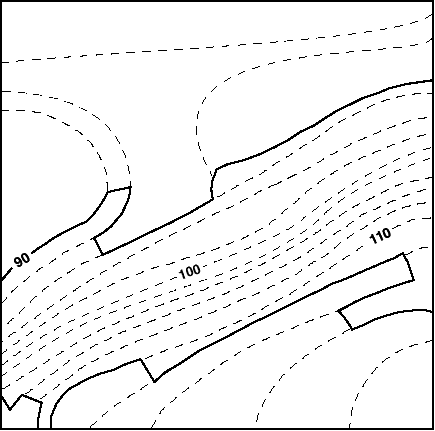
Example:

Where:
X - distance between contour lines which indicates a slope of 25 percent
In order to calculate the area having a slope equal to or greater than 25 percent, one can use a map with two-foot contour intervals and a scale of one inch equals 20 feet, such as the map pictured above. A 25 percent slope, on a map with two-foot contour intervals, is indicated by contour lines which are 8.0 feet apart, rounded to the nearest tenth (0.1) of a foot. On a map whose scale is one inch to 20 feet, 8.0 feet is represented by 0.4 of an inch, rounded to the nearest tenth (0.1) of an inch.
Identify where the contour lines are 0.4 of an inch or less apart. Connect these contour lines (as indicated by the heavy lines on the map) and calculate the area.
Buildable area
A "buildable area" is a portion of a zoning lot excluding steep slopes.
Caliper (of a tree)
"Caliper" of a tree is the diameter of a tree trunk measured 4 feet, 6 inches from the ground. If a tree splits into multiple trunks below 4 feet, 6 inches from the ground, the trunk is measured at its most narrow point beneath the split.
Critical root zone
The "critical root zone" of a tree is the area containing the roots of a tree that must be maintained and protected to ensure the tree's survival. The area of the critical root zone is measured as one radial foot for every caliper inch of the tree, with a required minimum of four radial feet and maximum of 22 radial feet, measured from the surface of the tree trunk at grade.
Hillside
A "hillside" is defined as ground where the ratio of change in elevation to horizontal distance results in a 10 percent or greater slope or average percent of slope.
Site alteration
For the purposes of this Chapter, a "site alteration" is an alteration on any vacant tract of land, land with minor improvements or any tract of land containing buildings or other structures. Site alterations shall include the following:
(a) removal of topsoil;
(b) excavating, filling, land contour work and other topographic modifications where the ground elevation of the land existing on June 30, 1987, is modified by two feet or more;
(c) dumping, changes in existing drainage systems and changes in grade, alignment or width of public rights-of-way; or
(d) removal of vegetation beyond 15 feet of the foundation of an existing building, except when the plant materials' continued presence would create hazards or dangers (such as an area affected by storm or plant disease) to persons, property or other plant material which it would not be possible or practical to eliminate by pruning or routine maintenance.
Staging area
A "staging area" is any area on a zoning lot or other tract of land used during the construction of a development, enlargement or site alteration for the purposes of stockpiling soil or construction materials; storing, cleaning or servicing construction equipment, vehicles or tools; or storing leachable construction products, gases or other materials used to clean or service vehicles, equipment or tools.
Steep slope
A "steep slope" is a portion of a zoning lot or other tract of land with an incline of 25 percent or greater. However, a portion of a zoning lot or other tract of land with an incline of 25 percent or greater shall not be considered a steep slope if it occupies an area of less than 200 square feet or has a dimension of less than 10 feet, measured along the horizontal plane, unless such portions in the aggregate equal 10 percent or more of the area of the zoning lot.
Steep slope buffer
A "steep slope buffer" is a 15-foot wide area having a slope of less than 25 percent that adjoins the entire length of the crest of a steep slope.
Tier I site
A "Tier I site" is a zoning lot or other tract of land having an average percent of slope of less than 10 percent.
Tier II site
A "Tier II site" is a zoning lot or other tract of land having an average percent of slope equal to or greater than 10 percent.
Topsoil
"Topsoil" is soil containing undisturbed humus and organic matter capable of sustaining vigorous plant growth and is generally the top six inches of soil.
Tree credit
A "tree credit" is a credit for preserving an existing tree of six-inch caliper or more which is counted toward a tree preservation requirement, or a credit for a newly planted tree of three-inch caliper or more which is counted toward a tree planting requirement.
Tree protection plan
A "tree protection plan" is a plan that modifies the area of no disturbance around a tree proposed for preservation while protecting and preserving the tree during construction. A tree protection plan is prepared by an arborist certified by the International Society of Arborculturists (ISA) or equivalent professional organization that includes:
(a) a survey of the current condition and health of such trees of six-inch caliper or more;
(b) methods for tree protection and preservation based on best management practices, including the prevention of damage due to compaction, grade and drainage pattern changes and tunneling for utilities;
(c) a schedule for site monitoring during construction;
(d) a procedure to communicate protection measures to contractor and workers; and
(e) post-construction treatment.
General Provisions
In harmony with the general purpose and intent of this Resolution and the general purposes of the Special Hillsides Preservation District, the regulations of the districts upon which this Special District is superimposed are supplemented or modified in accordance with the provisions of this Chapter. Except as modified by the express provisions of this Chapter, the regulations of the underlying districts remain in effect.
Any development, enlargement or site alteration on the buildable area of a zoning lot where the average percent of slope is less than 10 percent shall be regulated by the provisions set forth in Section 119-10 (PROVISIONS REGULATING TIER I SITES). Any development, enlargement or site alteration on the buildable area of a zoning lot having an average percent of slope equal to or greater than 10 percent shall be governed by the provisions set forth in Section 119-20 (PROVISIONS REGULATING TIER II SITES).
No development, enlargement or site alteration is permitted within any area of no disturbance on a zoning lot or other tract of land. Areas of no disturbance shall remain in their natural state, except:
(a) for steep slopes or steep slope buffers, an authorization may be granted by the City Planning Commission, pursuant to Section 119-30 (SPECIAL REVIEW PROVISIONS);
(b) vegetation and topsoil may be removed from a steep slope buffer during construction on a Tier I site, provided that the development, enlargement or site alteration complies with the requirements of Sections 119-215 (Landscaping controls to preserve trees, shrubs and ground cover), 119-217 (Tier II controls during construction) and 119-22 (Tier II Submission Requirements); or
(c) in accordance with a tree protection plan.
Those portions of a zoning lot having areas of no disturbance, however, may count as lot area for the purposes of the applicable regulations on yards, floor area ratio, open space ratio or maximum number of dwelling units or rooming units.
The following uses, including enlargements to such uses, shall not be permitted within the Special Hillsides Preservation District unless an authorization is granted by the Commission pursuant to Section 119-30: community facility uses, group parking facilities of 30 cars or more, whether or not they are necessary to satisfy parking requirements.
When the Special Hillsides Preservation District is designated on a public park, or portion thereof, site alterations, the construction of new park-related facilities such as, but not limited to, roadways, parking lots, comfort stations, storage facilities, swimming pools, eating establishments, tennis courts, amphitheaters and stadiums, and improvements to existing park-related facilities, shall not be subject to the provisions of Sections 119-10 or 119-20 but shall require an authorization from the Commission, pursuant to Section 119-31 (Authorizations).
In flood zones, in the event of a conflict between the provisions of this Chapter and the provisions of Article VI, Chapter 4 (Special Regulations Applying in Flood Zones), the provisions of Article VI, Chapter 4 shall control.
Any development on a zoning lot having an average percent of slope of 10 percent or greater, which is used predominantly for residential use, may be treated as a large-scale residential development and special authorizations or special permits for such developments may be granted in accordance with the provisions of Article VII, Chapter 8, as modified herein, regardless of whether such development will have the area, number of buildings or number of dwelling units specified in the definition of large-scale residential developments as set forth in Section 12-10 (DEFINITIONS). However, bonuses that may be granted for large-scale residential developments under the provisions of Sections 78-32 (Bonus for Good Site Plan), 78-33 (Bonus for Common Open Space) or 78-35 (Special Bonus Provisions) may not be granted for developments that have less than the minimum area, number of buildings or number of dwelling units required by the definition of a large-scale residential development.
Notwithstanding the provisions of Section 78-06 (Ownership), a zoning lot having an average percent of slope of 10 percent or greater that is the subject of an application under this Section may include adjacent properties in more than one ownership, provided that the application is filed jointly by the owners of all the properties included. Any subdivision of the tract before, during or after development shall be subject to the provisions of Section 78-51 (General Provisions).
Future Subdivision
Within the Special Hillsides Preservation District, no zoning lot existing on June 30, 1987, may be subdivided without certification by the City Planning Commission that the proposed subdivision complies with the regulations of the Special Hillsides Preservation District and that all hillsides are preserved to the greatest extent possible under future development options.
A plan for such subdivision shall be filed with the Commission and shall include a survey map indicating existing topography at two-foot contour intervals and all individual trees of six-inch caliper or more.
When a zoning lot existing on June 30, 1987, is intended to be subdivided and is more than five acres, a site plan of the entire subdivision shall be filed with the Commission. The site plan shall include the proposed vehicular circulation system within the area, block and zoning lot layouts and any other information required by the Commission.
In the event that any zoning lot proposed for subdivision contains a development, enlargement or site alteration that has been undertaken contrary to the provisions of this Chapter, the Commission shall not approve the subdivision until violations are removed from the zoning lot, in accordance with the Commission's requirements under Section 119-40 (COMPLIANCE).
The parking regulations applicable to lower density growth management areas are modified to allow required accessory parking spaces to be located in a front yard.
Tier I sites shall be regulated by the provisions set forth in this Section, inclusive.
Tier I Requirements
To the maximum extent possible, existing trees shall be retained. Trees of six-inch caliper or more may only be removed or destroyed as a result of a development, enlargement or site alteration, provided that:
(a) such trees are located in areas to be occupied by buildings, private roads, driveways, areas for required accessory parking, or within a distance of 15 feet of the exterior walls of such building, provided that it is not possible to avoid such removal by adjustments in the arrangement of such buildings, driveways or required parking areas;
(b) the continued presence of such tree would create special hazards or dangers to persons or property, which would not be possible or practical to eliminate by pruning;
(c) the continued presence of such tree would interfere with the growth or health of another tree of six-inch caliper or more designated for preservation and belonging to a species listed in Appendix B (Selection List for On-site Trees); or
(d) an authorization pursuant to Section 119-313 (Modification of landscaping, tree preservation and tree planting requirements) has been granted by the City Planning Commission approving the removal of such trees.
Any tree of six-inch caliper or more that cannot be preserved as a result of a proposed development, enlargement or site alteration shall be replaced pursuant to the provisions of Section 119-112 (Tier I tree planting requirements).
All developments, enlargements and site alterations on Tier I sites shall comply with the tree planting requirements set forth in this Section, whether or not existing trees are removed as a result of such development, enlargement or site alteration. However, the requirements set forth herein shall not apply to any enlargement of an existing building, provided that such enlargement does not increase the lot coverage of said building.
On-site trees, pre-existing or newly planted, shall be provided on the zoning lot at the rate of one tree for each 1,000 square feet of lot area, or portion thereof, or shall equal a total of 51 percent of all tree credits for trees originally on site, whichever is greater.
For any existing tree of at least six-inch caliper that is preserved, credit for one tree shall be given for the first six inches of caliper and, for each additional four inches of caliper, credit for an additional tree shall be given.
Single-trunk trees, newly planted to meet this requirement, shall be of at least three-inch caliper at the time of planting. Multiple-trunk trees and low-branching coniferous evergreens shall be at least 10 feet in height at the time of planting. On-site trees shall be of a species selected from Appendix B (Selection List for On-site Trees).
The following requirements must be met during construction:
(a) Construction fences shall be erected around all areas of no disturbance.
A tree protection plan is required to modify the area of no disturbance around trees proposed for preservation.
(b) The staging area shall be located in an area that would most minimize destruction of the natural features of the landscape. Such area shall be as close to the construction area on the zoning lot as practical, and shall be either on the flattest portion of the zoning lot or behind a containment wall where it will not erode any area of no disturbance or endanger any tree designated for preservation.
(c) Topsoil shall be used in the area to be revegetated as soon as construction is complete.
(d) Any exposed earth area shall have straw, jute matting or geotextiles placed on it within two days of exposure and be seeded with annual rye grass during construction.
For all developments, enlargements or site alterations on Tier I sites, the following materials shall be submitted to the Department of Buildings. However, the submission requirements set forth herein shall not apply to an enlargement of an existing residential building, provided that such enlargement does not increase the lot coverage of said building. No building permit shall be issued until the Department of Buildings determines that the requirements of the Special Hillsides Preservation District have been met.
(a) A survey map prepared by a licensed surveyor showing topography at two-foot contour intervals and indicating the existing slope of the land, as it occurs, in categories of 10–14 percent, 15–19 percent, 20–24 percent, 25 percent and greater; the location of existing buildings or other structures, patios, decks, swimming pools, walkways, driveways and private roads, including sidewalks and other impervious surfaces; and the location, caliper and species of all trees of six-inch caliper or more on the zoning lot and in the sidewalk area of the adjacent streets.
(b) A site plan prepared by a registered architect or professional engineer indicating the location of all existing buildings or other structures; the location of all proposed buildings or other structures; the location of existing and proposed patios, decks, swimming pools, walkways, driveways and private roads, including sidewalks and other impervious surfaces; the location of any steep slopes, steep slope buffer areas and the staging area; and the location, caliper and species of all trees of six-inch caliper or more on the zoning lot and in the sidewalk area of the adjacent streets. The site plan shall identify those trees proposed to be removed and those trees proposed to be preserved, indicating, for the latter, the critical root zone.
(c) A tree-planting plan, prepared by a registered landscape architect, indicating the location and species of all new plantings, and indicating the location of and the critical root zone around all trees proposed for preservation.
No permanent certificate of occupancy shall be issued by the Department of Buildings unless an inspection report, verifying that the requirements of Section 119-10 (PROVISIONS REGULATING TIER I SITES) have been met, is filed with the Department of Buildings by a registered landscape architect, licensed surveyor, registered architect or professional engineer.
All Tier II sites shall be regulated by the provisions set forth in this Section. However, any enlargement on Tier II sites of an existing building, provided that such enlargement does not increase the lot coverage of said building, shall be exempted from the provisions of Sections 119-211 (Lot coverage, floor area and density regulations), 119-213 (Grading controls) to 119-217 (Tier II controls during construction), inclusive, 119-22 (Tier II Submission Requirements), and 119-23 (Administration of Tier II Requirements).
Tier II Requirements
The area of a private road shall be excluded from the area of the zoning lot for the purposes of applying the applicable floor area ratio or lot coverage regulations of the applicable district. For the purposes of this Section, the area of the private road shall include the area of the paved roadbed plus a seven-foot wide area adjacent to and along the entire length of the required curbs.
The maximum permitted percentage of lot coverage on a zoning lot shall be determined by Table I or Table II of this Section, as applicable.
TABLE I
PERMITTED PERCENTAGE OF LOT COVERAGE ON A ZONING LOT BY ZONING DISTRICT, AVERAGE PERCENT OF SLOPE AND RESIDENCE TYPE
|
Residence District |
|||||||
|
Average Percent of Slope |
R1 |
R2 |
R3 |
R4 |
R5 |
R6: 1-2 Family |
R6: Other |
|
10—14.9 |
22.5 |
22.5 |
22.5 |
36.0 |
45.0 |
48.6 |
32.4 |
|
15—19.9 |
20.0 |
20.0 |
20.0 |
32.0 |
40.0 |
43.2 |
28.8 |
|
20—24.9 |
17.5 |
17.5 |
17.5 |
28.0 |
35.0 |
37.8 |
25.2 |
If an authorization is granted for a development, enlargement or site alteration on a portion of a zoning lot having a steep slope or steep slope buffer pursuant to Section 119-311, the maximum permitted percentage of lot coverage for said zoning lot shall not exceed the maximum set forth in Table II of this Section.
TABLE II
PERMITTED PERCENTAGE OF LOT COVERAGE ON A ZONING LOT OR PORTION OF A ZONING LOT WITH A STEEP SLOPE, BY ZONING DISTRICT AND RESIDENCE TYPE
|
Residence District |
||||||
|
R1 |
R2 |
R3 |
R4 |
R5 |
R6: 1-2 Family |
R6: Other |
|
12.5 |
12.5 |
12.5 |
20.0 |
25.0 |
27.0 |
18.0 |
However, the maximum permitted percentage of lot coverage on a zoning lot, as determined by Table I or Table II, shall not apply to any development, enlargement or site alteration that receives an authorization pursuant to Section 119-312 (Authorization of certain uses within the Special Hillsides Preservation District) and is located in a Commercial District.
Height and setback regulations
The underlying height and setback regulations shall be modified by the provisions of this Section.
No portion of a building or other structure shall penetrate a plane drawn parallel to the base plane at a height that is shown in Table III of this Section. For buildings with pitched roofs, height shall be measured to the midpoint of such pitched roof. For the purposes of this Section, the base plane, which is a plane from which the height of a building or other structure is measured in R2X, R3, R4 and R5 Districts, shall also be established in accordance with the provisions of Section 12-10 (DEFINITIONS) for buildings or other structures in R1, R2 and R6 Districts.
TABLE III
MAXIMUM HEIGHT OF A BUILDING OR OTHER STRUCTURE
|
Residence District * |
Maximum Height above Base Plane |
|
R1 R2 R3 R4 |
36 |
|
R4 |
45 |
|
R5 |
60 |
|
R6 |
70 |
* or Residence District equivalent when the zoning lot is located within a Commercial District
Grading controls
With the exception of private roads and driveways, no grading shall take place beyond 15 feet of the location of a building foundation, measured from the foundation perimeter. The following grading requirements shall apply to all Tier II sites.
(a) Cut slopes shall be no steeper than two horizontal to one vertical; subsurface drainage shall be provided as necessary for stability.
(b) Where two cut slopes intersect, the corners shall be rounded with a minimum radius of 25 feet.
(c) Fill slopes shall be no steeper than two horizontal to one vertical; fill slopes shall not be located on natural slopes 2:1 or steeper, or where fill slope toes out within 12 feet horizontally of the top of an existing or planned cut slope.
(d) Excavating for fill shall be prohibited unless the material is obtained from a cut permitted under an approved grading plan obtained for some purpose other than to produce fill material, or imported from outside the Special Hillsides Preservation District.
(e) Fills shall be compacted to at least 95 percent of maximum density, as determined by AASHTO T99 or ASTM D698.
(f) All retaining walls or cuts with a total vertical projection in excess of three feet and associated with cut or fill surfaces shall be designed as structural members keyed into stable foundations and capable of sustaining the design loads.
(g) The edge of any cut or fill slope meeting the grade existing on June 30, 1987, should be blended into such grade in a vertical or horizontal arc with a radius of not less than 25 feet.
(h) The top and toe of any cut or fill slope, or where any excavation meets the grade existing on June 30, 1987, should be rounded in a vertical arc with a radius of not less than five feet.
(i) Tops and toes of cut and fill slopes shall be set back from lot lines for a horizontal distance of three feet plus one-fifth the height of the cut or fill but need not exceed a horizontal distance of 10 feet; tops and toes of cut and fill slopes shall be set back from buildings and structures a horizontal distance of six feet plus one-fifth the height of the cut or fill but need not exceed a horizontal distance of 10 feet.
The provisions set forth in this Section and Section 119-213 (Grading controls) shall apply to driveways and to private roads that provide access to buildings developed after December 11, 1999. The provisions for private roads set forth in Section 26-20, inclusive, shall not apply. However, the provisions of Sections 26-23 (Yards), 26-31 (Entrances, Parking Location and Curb Cuts) and 26-32 (Lighting, Signage and Crosswalks) shall apply for private roads in lower density growth management areas.
(a) Driveways
(1) the maximum grade of a driveway shall not exceed 10 percent;
(2) the paved width of a driveway shall not exceed 18 feet; and
(3) the maximum length of a driveway from a private road or street to an accessory parking space shall not exceed 80 feet.
(b) Private roads
(1) the maximum grade of a private road shall not exceed 10 percent;
(2) the width of the graded section beyond the curb back or edge of pavement of a private road shall extend no more than three feet beyond the curb back or edge of pavement on both the cut and the fill sides of the roadway. If a sidewalk is to be installed parallel to the roadway, the graded section shall be increased by the width of the sidewalk plus no more than one foot beyond the curb back;
(3) the paved width of a private road shall not exceed 30 feet;
(4) curbs shall be provided along each side of the entire length of a private road and accessory parking spaces may be located between the required roadbed and curb;
(5) a curb cut, excluding splays, from a street to a private road may be as wide as such private road;
(6) curb cuts providing access from private roads to parking spaces shall not exceed the width of the driveway served and in no event shall exceed a width of 18 feet, including splays;
(7) a minimum distance of 16 feet of uninterrupted curb space shall be maintained between all curb cuts;
(8) no building permit shall be issued by the Department of Buildings without approval by the Fire Department regarding the adequacy of vehicular access to and within the development for fire safety. Such approval may include the modification of private road width as set forth in paragraph (b)(3) of this Section; and
(9) for the purposes of applying the yard regulations of Section 26-23, the curb of the private road shall be considered to be the street line.
The City Planning Commission may by authorization or special permit, as applicable, pursuant to Section 119-30 (SPECIAL REVIEW PROVISIONS), allow modifications to, or waivers of, the requirements of this Section. The approval of the Fire Department regarding the adequacy of vehicular access to and within the development for fire safety shall be a condition precedent for any modification or waiver.
(a) In any area of no disturbance, existing vegetation and topsoil shall not be removed, except in accordance with a tree protection plan or as authorized by the City Planning Commission, pursuant to the provisions of Section 119-313 (Modification of landscaping, tree preservation and tree planting requirements).
(b) To the maximum extent possible, existing trees, shrubs and ground cover shall be retained. Vegetation may only be removed or destroyed as a result of a development, enlargement or site alteration, provided that:
(1) it is located in areas to be occupied by buildings, private roads, driveways, areas for required accessory parking or within a distance of 15 feet of a building foundation and, provided that it is not practical to avoid such removal by adjustments in the arrangement of such buildings, private roads, driveways or required parking areas;
(2) the continued presence of the vegetation would interfere with the growth or health of trees of six-inch caliper or more designated for preservation and belonging to a species listed in Appendices A, B or C;
(3) the continued presence of the vegetation would create special hazards or dangers to persons or property, which would not be possible or practical to eliminate by pruning or routine maintenance; or
(4) an authorization has been granted by the City Planning Commission under the provisions of Section 119-313 approving the removal of such vegetation.
(c) Any vegetation or topsoil that cannot be preserved as a result of a proposed development, enlargement or site alteration and is not permitted to be removed under paragraph (b) of this Section shall be replaced as follows: for every square foot of lot area of removed vegetation or topsoil, there shall be provided the following plantings of the size and number indicated in paragraphs (c)(1) through (c)(4) of this Section. The area of removed vegetation shall be measured so as to include any portions of the zoning lot that were located within the critical root zone of a removed tree of six-inch caliper or more. Species of ground cover and shrubs shall be selected from Appendix A (Selection List for Ground Covers and Shrubs). Species of on-site trees shall be selected from Appendix B (Selection List for On-site Trees).
(1) Ground cover shall be planted one at one foot on center and at the rate of one plant for every square foot of lot area of removed vegetation; and
(2) Large trees shall be planted at the rate of one three-inch caliper tree for every 500 square feet of lot area of removed vegetation; or
(3) Small trees shall be planted at a rate of one eight-foot high tree for every 100 square feet of lot area of removed vegetation; or
(4) Shrubs shall be planted at a rate of one gallon container-grown material for every 25 square feet of lot area of removed vegetation.
All developments, enlargements and site alterations on Tier II sites shall comply with the following tree planting requirements, whether or not existing vegetation is removed as a result of such development, enlargement or site alteration. However, the requirements set forth herein shall not apply to an enlargement of an existing building, provided that such enlargement does not increase the lot coverage of said building.
On-site trees, pre-existing or newly-planted, shall be provided on the zoning lot at the rate of one tree for each 1,000 square feet of lot area, or portion thereof, or shall equal a total of 51 percent of all tree credits for trees originally on site, whichever is greater.
For any existing tree of at least six-inch caliper that is preserved, credit for one tree shall be given for the first six inches of caliper and, for each additional four inches of caliper, credit for an additional tree shall be given.
Single-trunk trees newly planted to meet this requirement shall be of at least three-inch caliper at the time of planting. Multiple-trunk trees and low-branching coniferous evergreens shall be at least 10 feet in height at the time of planting. On-site trees shall be of a species selected from Appendix B (Selection List for On-site Trees).
The following requirements must be met during construction:
(a) No construction equipment of any kind shall operate beyond 15 feet of the perimeter of a building foundation except those vehicles engaged in the construction of private roads, driveways or required accessory parking areas. This provision may be waived by the Commissioner of Buildings should it be determined that the particular conditions of the site make a 15 foot limit infeasible or impractical.
(b) Construction fences shall be erected around all vegetation proposed for preservation and all areas of no disturbance, and those portions of the fence that are downhill from the construction site shall have hay bales placed adjacent to them.
(c) Excavating for fill shall be prohibited unless the material is obtained from a cut permitted under an approved grading plan obtained for some purpose other than to produce fill material, or imported from outside the Special Hillsides Preservation District.
(d) The staging area shall be located in an area that would most minimize destruction of the natural features of the landscape. Such area shall be as close to the construction area on the zoning lot as practical, and shall be either on the flattest portion of the zoning lot or behind a containment wall where it will not erode any area of no disturbance or endanger any tree designated for preservation.
(e) Topsoil shall be used in the area to be revegetated as soon as construction is complete.
(f) Any exposed earth area shall have straw, jute matting or geotextiles placed on it within two days of exposure and be seeded with annual rye grass during construction.
For all developments, enlargements or site alterations on Tier II sites, the following materials shall be submitted to the Department of Buildings. However, the submission requirements set forth herein shall not apply to an enlargement of an existing building, provided that such enlargement does not increase the lot coverage of said building. No building permit shall be issued until the Department of Buildings determines that the requirements of the Special Hillsides Preservation District have been met.
(a) A survey map prepared by a licensed surveyor showing topography at two-foot contour intervals and indicating the existing slope of the land as it occurs in categories of 10–14 percent, 15–19 percent, 20–24 percent, 25 percent and greater; the location of existing buildings or other structures, patios, decks, swimming pools, walkways, driveways and private roads, including sidewalks and other impervious surfaces; and the location, caliper and species of all trees of six-inch caliper or more on the zoning lot and in the sidewalk area of the adjacent streets.
(b) A site plan prepared by a registered architect or professional engineer indicating the location of all existing buildings or other structures; the location of all proposed buildings or other structures; the location of existing and proposed patios, decks, swimming pools, walkways, driveways and private roads, including sidewalks and other impervious surfaces; the location of all understory, including shrubs and ground cover; and the location, caliper and species of individual trees of six-inch caliper or more on the zoning lot and in the sidewalk area of the adjacent streets. The site plan shall identify those trees proposed to be removed and those trees proposed to be preserved, indicating for the latter the critical root zone, the location of any other area of no disturbance and the location of the staging area.
(c) A grading plan that will show all existing and proposed contours at two-foot intervals, critical spot elevations, tops and bottoms of proposed slopes over 10 percent gradient and will indicate at least one longitudinal and one latitudinal cross-section showing both the original and proposed final ground surfaces, with grades, slopes and elevations noted.
(d) An alignment and paving plan for any private road with a typical cross-section.
(e) A landscaping and revegetation plan, prepared by a registered landscape architect, indicating the extent of vegetation and topsoil removal required for site preparation and development and the location and species of all new plantings.
(f) A construction plan prepared by a registered landscape architect, registered architect, licensed surveyor or professional engineer showing the proposed location for the staging area, the proposed method for protecting trees, understory shrubs and ground cover during construction, as well as a description of the equipment to be employed in processing and disposing of soil and other material to be removed from the site. A tree protection plan for any tree proposed for preservation where the area of no disturbance is proposed to be modified.
(g) An affidavit prepared by a registered landscape architect, registered architect, licensed surveyor or professional engineer stipulating the following:
(1) prior to construction, no grading, filling, clearing or excavation of any kind shall be initiated until approval of a final grading plan by the Department of Buildings;
(2) no construction equipment of any kind shall pass over areas to be preserved, according to the approved plans;
(3) construction fences meeting the requirements of paragraph (b) of Section 119-217 shall be erected around all vegetation proposed for retention; and
(4) construction controls (erosion protection, drainage measures, etc.) shall be implemented according to the approved plan.
(h) A drainage plan and soil report prepared by a professional engineer to protect natural features. The drainage plan shall describe the temporary (during construction) and permanent measures to collect, direct and discharge stormwater drainage from the site, indicating the direction of drainage flow and providing detailed plans and locations of all surface and subsurface drainage devices, walls, dams, sediment basins, stormwater storage (detention and retention) facilities, and other drainage facilities and protective devices. Such report shall include an estimate of runoff from the site after completion of any proposed development, enlargement or site alteration and provide a description with supporting information of the manner in which the proposed development, enlargement or site alteration complies with the requirements of Local Law 103 of 1989.
All developments, enlargements or site alterations that are subject to the requirements of Section 119-22 (Tier II Submission Requirements) shall file directly with the Department of Buildings.
No permanent certificate of occupancy shall be granted unless an inspection report, verifying that the requirements of Section 119-20 have been met, is filed with the Department of Buildings by a registered landscape architect, registered architect, licensed surveyor or professional engineer.
SPECIAL REVIEW PROVISIONS
Authorizations
Upon application, the City Planning Commission may grant authorizations for modifications of specified regulations of this Chapter and for the underlying district regulations in accordance with the provisions of Sections 119-311 (Authorization of a development, enlargement or site alteration on a steep slope or steep slope buffer) through 119-319 (Authorization to allow site alterations, the construction of new park-related facilities and improvements to existing park-related facilities within public parks), inclusive.
In addition, all developments, enlargements and site alterations that require an authorization pursuant to Sections 119-311 through 119-318, inclusive, shall be subject to the provisions of Sections 119-33 (Special Erosion and Sedimentation Prevention Requirements for Certain Authorizations and Special Permits) and 119-34 (Special Submission Requirements for Certain Authorizations and Special Permits).
The Commission may prescribe appropriate conditions and safeguards, including covenants running with the land which shall permit public or private enforcement reflecting terms, conditions and limitations, of any authorizations hereunder, to minimize adverse effects on the hillsides and the character and quality of the community.
The City Planning Commission may authorize developments, enlargements and site alterations on a steep slope or steep slope buffer.
In order to grant such authorizations, the Commission shall find that:
(a) the development, enlargement or site alteration is not feasible without such modification, or that the requested modification will permit a development, enlargement or site alteration that satisfies the purposes of this Chapter;
(b) such modification is the least modification required to achieve the purpose for which it is granted;
(c) the modification requested has minimal impact on the existing natural topography and vegetation and blends harmoniously with it;
(d) the requested modification will not disturb the drainage patterns and soil conditions of the area; and
(e) the development, enlargement or site alteration takes advantage of the natural characteristics of the site.
Any development, enlargement or site alteration requiring an authorization pursuant to this Section shall be subject to all the requirements of Section 119-20 (PROVISIONS REGULATING TIER II SITES) for which an authorization or special permit has not been obtained.
Any group parking facility with 30 cars or more and, in Residence Districts, any community facility use or enlargement thereof, shall be allowed only by authorization of the City Planning Commission. In order to grant such authorizations, the Commission, upon review of a site plan, shall find that:
(a) the proposed development, enlargement or site alteration will not adversely affect the drainage pattern and soil conditions of the area;
(b) the proposed development, enlargement or site alteration has minimal impact on the existing natural topography and vegetation and blends harmoniously with it;
(c) such development, enlargement or site alteration is so located as not to impair the essential character of the surrounding area;
(d) the design of such development, enlargement or site alteration takes full advantage of all special characteristics of the site;
(e) vehicular access and egress for such development, enlargement or site alteration is located and arranged so as to draw a minimum of vehicular traffic to and through local streets in nearby residential areas; and
(f) where vehicular access and egress is located on an arterial, such location affords the best means for controlling the flow of traffic generated by such development to and from such arterial.
The Commission may permit modifications to parking lot landscaping and maneuverability requirements for applications for such authorizations of group parking facilities for over 30 cars or for enlargements to group parking facilities, if such modifications preserve vegetation and natural topography.
The City Planning Commission may authorize modifications to Sections 119-111 (Tier I tree preservation requirements), 119-112 (Tier I tree planting requirements), paragraph (b)(8) of Section 119-214 (Tier II requirements for driveways and private roads), 119-215 (Landscaping controls to preserve trees, shrubs and ground cover) and 119-216 (Tier II tree planting requirements).
In order to grant such authorizations, the Commission shall find that:
(a) the development, enlargement or site alteration is not feasible without such modifications, or that the requested modification will permit a development, enlargement or site alteration that satisfies the purposes of this Chapter;
(b) such modification is the least modification required to achieve the purpose for which it is granted; and
(c) the ecology and soil conditions of the site are such that the substitution of other plant material would be as appropriate as the tree preservation or planting requirements being modified.
Where on-site restoration of vegetation would result in overcrowding or would adversely affect the ecology of the site, the Commission may authorize planting of one or more trees on adjoining public sidewalks or in a nearby public area within the Special Hillsides Preservation District. The Commission may also allow the substitution of other plant material, provided a detailed landscaping plan is filed with the Commission for approval and certification.
For any development or enlargement subject to Section 119-211 (Lot coverage, floor area and density regulations), the City Planning Commission may authorize variations in the lot coverage controls.
In order to grant such authorization, the Commission shall find that:
(a) the development or enlargement is not feasible without such modification, or that the requested modification will permit a development or enlargement that satisfies the purpose of this Chapter;
(b) by allowing the permitted floor area in a building or buildings of lower height to cover more land, the preservation of hillsides having aesthetic value to the public would be assured, and that such preservation would not be possible by careful siting of a higher building containing the same permitted floor area on less land;
(c) such modification is the least modification required to achieve the purpose for which it is granted;
(d) the modification requested has minimal impact on the existing natural topography and vegetation and blends harmoniously with it;
(e) the requested modification will not disturb the drainage pattern and soil conditions of the area; and
(f) the proposed modification does not impair the essential character of the surrounding area.
For any Tier II site, the City Planning Commission may authorize variations in the height and setback regulations set forth in Section 119-212 (Height and setback regulations).
In order to grant such authorizations, the Commission shall find that:
(a) the development or enlargement is not feasible without such modification, or that the requested modification will permit a development or enlargement that satisfies the purpose of this Chapter;
(b) by concentrating permitted floor area in a building or buildings of greater height covering less land, the preservation of existing topography and vegetation and the preservation of hillsides having aesthetic value to the public will be assured, and that such preservation would not be possible by careful siting of lower buildings containing the same permitted floor area and covering more land;
(c) such modification is the least modification required to achieve the purpose for which it is granted;
(d) the requested modification will not disturb the soil conditions of the area;
(e) the proposed modification does not impair the essential character of the surrounding area; and
(f) the proposed modification will not have adverse effects upon light, air and privacy of adjacent properties.
Modification of grading controls
For any development, enlargement or site alteration on a Tier II site, the City Planning Commission may authorize variations in the grading controls set forth in Section 119-213.
In order to grant such authorization, the Commission shall find that:
(a) the development, enlargement or site alteration is not feasible without such modifications, or that the requested modifications will permit a development, enlargement or site alteration that satisfies the purposes of this Chapter;
(b) such modification is the least modification required to achieve the purpose for which it is granted;
(c) the requested modification has minimal impact on the existing natural topography and vegetation and blends harmoniously with it;
(d) the requested modification will not disturb the drainage pattern and soil conditions of the area;
(e) the proposed modification does not impair the essential character of the surrounding area; and
(f) the benefits to the surrounding area from the proposed modification outweigh any disadvantages that may be incurred thereby in the area.
For any development, enlargement or site alteration, the City Planning Commission may authorize variations in the requirements for private roads and driveways on any Tier II site as set forth in Section 119-214 (Tier II requirements for driveways and private roads) as well as the requirements of Sections 25-621 (Location of parking spaces in certain districts), 25-624 (Special parking regulations for certain community facility uses in lower density growth management areas) and 25-631 (Location and width of curb cuts in certain districts).
In order to grant such authorizations, the Commission shall find that:
(a) the development or enlargement is not feasible without such modification, or that the requested modification will permit a development, enlargement or site alteration that satisfies the purposes of this Chapter;
(b) such modification is the least modification required to achieve the purpose for which it is granted;
(c) the requested modification will not disturb the drainage pattern and soil conditions of the area;
(d) the requested modification has minimal impact on the existing natural topography and vegetation and blends harmoniously with it; and
(e) such modification will enhance the quality of the design of the development, enlargement or site alteration.
For any development or enlargement subject to Section 119-20 (PROVISIONS REGULATING TIER II SITES), the City Planning Commission may authorize variations in required front, rear or side yards, variations in required space between buildings on the same zoning lot and modifications in the underlying district height and setback regulations.
In order to grant such authorizations, the Commission shall find that:
(a) development is not feasible without such modification, or that the requested modification will permit a development, enlargement or site alteration that better satisfies the purposes of this Chapter;
(b) such modification is the least modification required to achieve the purpose for which it is granted; and
(c) the proposed bulk and placement of buildings and the proposed arrangement of open spaces will not have significant adverse effects upon the light, air and privacy for existing development in adjacent areas or the opportunities therefor in future development.
Upon application, the City Planning Commission may authorize site alterations, the construction of new park-related facilities such as, but not limited to, roadways, parking lots, comfort stations, storage facilities, swimming pools, eating establishments, tennis courts, amphitheaters and stadiums, and improvements to existing park-related facilities.
In order to grant such authorizations, the Commission shall find that the proposed action:
(a) will have a minimal impact on the existing natural topography of the surrounding area and will blend harmoniously with it;
(b) will have minimal impact on the drainage pattern and soil conditions in the area;
(c) will preserve to the greatest extent possible the trees and vegetation within the park; and
(d) is compatible with the neighborhood character of the area.
An application to the Commission for an authorization pursuant to this Section shall include the following:
(1) a survey map prepared by a licensed surveyor showing existing topography at the two-foot contour intervals;
(2) a site plan prepared by a registered architect, registered landscape architect or professional engineer indicating the location of all existing buildings or other structures, the location of all proposed buildings or other structures, the location of all understory including shrubs and ground cover, and the caliper and species of all individual trees of six-inch caliper or more; and
(3) any other information necessary to evaluate the request.
In issuing authorizations under this Section, the Commission may impose conditions or safeguards, such as special landscape requirements, to minimize adverse effects on the character of the Special Hillsides Preservation District.
Special Permits
The City Planning Commission may grant special permits for modification of the underlying district regulations in accordance with the provisions of Section 119-321 (Modification of use regulations).
Modification of use regulations
For any Tier II site, the City Planning Commission may grant special permits to allow single-family semi-detached residences in R1 and R2 Districts, single-family attached residences in R1, R2 and R3-1 Districts or two-family attached residences in R3-1 Districts.
As a condition for granting such special permits, the minimum required lot area of the underlying district shall not be reduced, and the aggregate width of street walls of a building, or a number of buildings separated by party walls, shall not exceed 100 feet.
In order to grant such special permits, the Commission shall find that:
(a) development is not feasible without such modifications, or that the requested modification will permit a development, enlargement or site alteration that better satisfies the purposes of this Chapter;
(b) the change of housing type requested constitutes the most effective method of preserving the existing topography and vegetation;
(c) the preservation of existing topography and vegetation requires the permitted development to be concentrated, to the extent feasible, in the remaining portion of the tract;
(d) for such concentration of development, better standards of privacy and usable open space can be and are achieved under the development plan by inclusion of the proposed building type;
(e) such modification is the least modification required to achieve the purpose for which it is granted;
(f) the proposed street or private road system for the development is so located as to draw a minimum of vehicular traffic to and through streets in the adjacent area;
(g) the siting of the building or buildings will not adversely affect adjacent properties by impairing privacy or access of light and air; and
(h) the existing topography and vegetation and the proposed planting effectively screen all attached one-family residences from the lot lines along the development perimeter.
The Commission may impose appropriate conditions or safeguards, such as special landscaping requirements, to minimize any adverse effects on the character of the surrounding area.
All developments, enlargements or site alterations that require a special permit pursuant to this Section shall also be subject to the provisions of Sections 119-33 (Special Erosion and Sedimentation Prevention Requirements for Certain Authorizations and Special Permits) and 119-34 (Special Submission Requirements for Certain Authorizations and Special Permits).
Any development, enlargement or site alteration that requires an authorization or special permit and that is subject to the provisions of Section 119-20 (PROVISIONS REGULATING TIER II SITES), shall be subject to the provisions of this Section. The requirements of this Section shall supplement any other requirements that also must be met.
Prior to construction, at least one of the erosion and sedimentation control measures described in paragraphs (a) through (e) of the Section shall be selected. A plan describing how the selected erosion and sedimentation control measure will be implemented and justifying its selection on the basis of the particular conditions of the site shall be prepared by a professional engineer and submitted to the City Planning Commission.
(a) Benches and berms
These are level terraces or ledges constructed across sloping land to provide a relatively flat construction site or to reduce the length and grade of the slope. Benches and berms reduce runoff and erosion hazards by slowing down the velocity of water and providing greater intake opportunity.
(b) Diversion channels
These are earth channels with a supporting ridge on the lower side constructed across the slope lengths to break up concentration of runoff and move water to stable outlets at a non-erosive velocity.
(c) Debris or sediment basins
These consist of a dam or embankment, a pipe outlet and an emergency spillway situated at the low corner of the site to provide a temporary means of trapping and storing sediment while releasing the water. They protect property below the installation from damage by excessive sedimentation and debris.
(d) Retention ponds
These are impoundment-type ponds that temporarily store runoff water and release it at rates that minimize erosion and prevent flooding. They may be located above the site to trap water before it enters the area or within the site to protect properties below the site.
(e) Grassed waterways or outlets
These are natural or excavated channels to dispose of excess runoff water from diversions, berms, benches and other areas at non-erosive velocities. Waterways or outlets are shaped or graded and established in suitable vegetation as needed, depending on the supplemental measure used to slow the velocity of runoff.
When a development, enlargement or site alteration is subject to the provisions of Section 119-20 (PROVISIONS REGULATING TIER II SITES), an application to the City Planning Commission for an authorization or special permit shall include the following submission requirements. These requirements shall be in addition to the requirements set forth in Section 119-22 (Tier II Submission Requirements).
(a) A drainage plan and soil report prepared by a professional engineer to protect natural features. The drainage plan shall describe the temporary (during construction) and permanent measures to collect, direct and discharge stormwater drainage from the site, indicating the direction of drainage flow and providing detailed plans and locations of all surface and subsurface drainage devices, walls, dams, sediment basins, stormwater storage (detention and retention) facilities, and other drainage facilities and protective devices. Such report shall include an estimate of runoff from the site after completion of proposed developments, enlargements or site alterations and provide a description with supporting information of the manner in which the proposed development, enlargement or site alteration complies with the requirements of Local Law 103 of 1989.
(b) An erosion and sedimentation plan as described in Section 119-33 (Special Erosion and Sedimentation Prevention Requirements for Certain Authorizations and Special Permits).
(c) For any development or site alteration on a tract of land 40,000 square feet or greater, a landscape plan prepared by a registered landscape architect that shows the location and species of all new plantings of trees, shrubs and ground covers and the proposed method of preserving existing trees, shrubs and ground covers.
(d) Any other information the Commission may deem necessary to evaluate the request.
The applicant's submission shall also include a statement admitting authorized Department of City Planning personnel to the site for the purposes of recording or verifying survey data.
Where a permit other than a building permit is required for a development, enlargement or site alteration within the Special Hillsides Preservation District from any City agency, an application for such permit shall be filed simultaneously with such agency and the City Planning Commission.
No permanent certificate of occupancy shall be granted unless an inspection report, verifying that the requirements of Sections 119-20 (PROVISIONS REGULATING TIER II SITES) and 119-30 (SPECIAL REVIEW PROVISIONS) have been met, is filed with the Department of Buildings by a registered landscape architect, licensed surveyor or professional engineer.
COMPLIANCE
In the event that a development, enlargement or site alteration is undertaken, or has been undertaken, contrary to the provisions of this Chapter, any permit issued by the Department of Buildings for any use, development, enlargement or site alteration on the affected zoning lot shall be revoked.
No building permit or permanent certificate of occupancy shall be issued by the Department of Buildings for any use, development, enlargement or site alteration on such zoning lot until the violations are removed from the zoning lot, pursuant to a restoration plan certified by the City Planning Commission.
If such violations have not ceased within 90 days of receipt of the Commission's requirements, the Department of Buildings shall institute such action as may be necessary to prosecute the violations. For compliance with restoration requirements to remove violations, the Department of Buildings may allow an additional 90 days.
Where on-site restoration of vegetation would result in overcrowding or would adversely affect the ecology of the site, the Commission may authorize planting of one or more trees on adjoining public sidewalks or in a nearby public area within the Special Hillsides Preservation District. The Commission may also allow the substitution of other plant material, provided a detailed landscaping plan is filed with the Commission for approval and certification.
Appendix A
Selection List for Ground Covers and Shrubs
Ground Covers
BOTANICAL NAME | COMMON NAME |
Adiantum pedatum | Maidenhair fern |
Agrostis perennans (A. altissima) | Autumn bent-grass |
Anaphalis margaritacea | Pearly everlasting |
Andropogon gerardii | Big bluestem |
Andropogon glomeratus | Bushy bluestem |
Andropogon virginicus | Broom Sedge |
Anemone canadensis | Canada anemone |
Antennaria plantaginifolia | Plantain-leaved pussytoes |
Arctostaphylos uvaursi | Bearberry |
Asarum canadense | Wild ginger |
Aster cordifolius | Heart-leaved aster |
Aster divericatus | White wood aster |
Aster ericoides | Heath aster |
Aster lanceolatus (A. simplex) | Lined aster |
Aster macrophyllus | Large-leaved aster |
Aster novae angliae | New England aster |
Athyrium filix femina (A. asplenoides) | Lady fern |
Athyrium thelypteroides | Silvery glade fern |
Carex appalachica (C. radiata) | Sedge |
Carex pensylvanica | Pennsylvania sedge |
Chimaphila maculata | Spotted or stripped wintergreen/Pipsissewa |
Chimaphila umbellata | Pipsissewa, Prince's pine, Bitter wintergreen |
Chrysopsis mariana | Maryland golden aster |
Danthonia compressa | Flattened oat grass |
Danthonia spicata | Oatgrass, Poverty grass |
Dennstaedtia punctilobula | Hay-scented fern |
Deschampsia cespitosa | Tufted hair grass |
Deschampsia flexuosa | Common hair grass, Crinkled hair grass |
Dryopteris intermedia | Common wood fern |
Dryopteris marginalis | Marginal wood fern, Leatherleaf wood fern |
Erigeron philadelphicus | Daisy fleabane |
Eupatorium maculatum | Spotted JoePye weed |
Eupatorium rugosum | White snakeroot |
Eupatorium sessilifolium | Upland boneset |
Fragaria virginiana | Wild strawberry, Virginia strawberry |
Gaultheria hispidula | Creeping snowberry, Creeping pearl berry |
Gaultheria procumbens | Wintergreen, Teaberry, Checkerberry |
Geranium maculatum | Wild geranium, Spotted cranesbill |
Geum canadense | White avens, Winter rosette |
Heuchera americana | Hairy alum root, Rock geranium |
Hypericum ellipticum | Pale St. John's Wort |
Muhlenbergia schreberi | Nimblewill |
Oenothera fruticosa | Sundrops, Wild beet, Suncups, Scabish |
Onoclea sensibilis | Sensitive fern, Bead fern |
Osmunda claytoniana | Interrupted fern |
Panicum clandestinum | Deer tongue grass |
Panicum virgatum | Switch grass, Wild red top, Thatch grass |
Parthenocissus quinquefolia | Virginia creeper, Woodbine, American ivy |
Phlox subulata | Mountain phlox, Moss pink, Moss phlox |
Polygonatum biflorum | Smooth Solomon’s seal, True King Solomon’s seal |
Polygonatum virginianum (Tovaria v.) | Jumpseed |
Polypodium virginianum | P. vulgare, Rocky polypody, Am. wall fern |
Polystichum acrostichoides | Christmas fern, Dagger fern, Canker break |
Rudbeckia hirta var. hirta | Black-eyed Susan |
Rudbeckia triloba | Thin-leaved cone flower |
Thelypteris noveboracensis | New York fern |
Tiarella cordifolia | Allegheny foamflower, False mitrewort |
Tradescantia virginiana | Virginia Spiderwort, Common S., Widow's tears |
Verbena hastata | Blue vervain |
Vernonia noveboracensis | New York ironweed |
Verbesina alternifolia (Actinomeria a.) | Wingstem |
Viola sororia | Woolly blue violet sister violet, Dooryard violet |
Shrubs
Amelanchier canadensis | Shadblow |
Amelanchier laevis (A. arborea) | Serviceberry, Allegheny |
Aronia arbutifolia | Red chokeberry |
Aronia melanocarpa | Black chokeberry |
Clethra alnifolia | Sweet pepperbush, Summersweet |
Comptonia peregrina | Sweet fern, Meadow fern, Spleenwort bush |
Cornus amomum | Silky dogwood |
Cornus racemosa | Gray dogwood, Red-panicled dogwood |
Cornus sericea (C. stolonifera) | Red osier dogwood |
Corylus americana | American hazelnut |
Corylus cornuta | Beaked hazelnut |
Diervilla lonicera | Bush honeysuckle, Blue herb, Gravel weed |
Hamamelis virginiana | Witch hazel |
Ilex glabra | Inkberry, Gallberry |
Ilex verticillata | Winterberry |
Juniperus communis | Common juniper |
Juniperus horizontalis | Creeping juniper, Creeping cedar/Savin |
Kalmia angustifolia | Sheep laurel |
Kalmia latifolia | Mountain laurel |
Lindera benzoin | Spice bush |
Myrica pensylvanica | Northern bayberry |
Physocarpus opulifolius | Common ninebark |
Potentilla fruticosa | Cinquefoil, Bush cinquefoil |
Rhododendron maximum | Great laurel |
Rhododendron periclymenoides | Pinkster azalea |
Rhododendron viscosum | Swamp azalea |
Rhus aromatica | Fragrant sumac, Sweet scented sumac/Lemon sumac |
Rhus copallina | Winged sumac |
Rhus glabra | Smooth sumac |
Rhus typhina | Staghorn sumac |
Rosa blanda | Smooth rose, Meadow rose |
Rubus allegheniensis | Common blackberry, Allegheny blackberry |
Salix humilis | Prairie willow |
Salix lucida | Shining willow |
Sambucus canadensis | American elderberry |
Spirea tomentosa | Hardhack spirea |
Vaccinium angustifolium | Lowbush blueberry |
Vaccinium corymbosum | Highbush blueberry |
Viburnum acerifolium | Maple leaf viburnum |
Viburnum alnifolium (V. Lantanoides) | Hobble bush |
Viburnum dentatum | Arrowwood viburnum |
Viburnum lentago | Nanny-berry |
Viburnum prunifolium | Black-haw |
Appendix B
Selection List for On-site Trees
Small Trees
BOTANICAL NAME | COMMON NAME |
Amelanchier laevis | Serviceberry |
Betula nigra | River birch |
Betula populifolia | Grey birch |
Carpinus caroliniana | Hornbeam |
Cercis canadensis | Eastern redbud |
Cornus florida | Flowering dogwood |
Crataegus crus-galli inermis | Thornless cockspur hawthorn |
Crataegus phaenopyrum | Washington hawthorn |
Hamamelis virginiana | Witch hazel |
Ilex opaca | American holly |
Juniperus virginiana | Eastern red cedar |
Populus tremuloides | Quaking aspen |
LARGE TREES | |
BOTANICAL NAME | COMMON NAME |
Acer rubrum | Red maple |
Acer saccharum | Sugar maple |
Betula lenta | Black/Sweet birch |
Betula papyrifera | Paper birch |
Celtis occidentalis | Common hackberry |
Chamaecyparis thyoides | Cedar, Atlantic white |
Fagus grandifolia | American beech tree |
Fraxinus americana | Ash, white |
Fraxinus pennsylvanica | Ash, green |
Larix laricina | Tamarack/American larch |
Liquidambar styraciflua | Sweet gum |
Liriodendron tulipifera | Tulip tree |
Nyssa sylvatica | Black tupelo |
Picea rubens | Spruce, red |
Pinus resinosa | Pine, red |
Pinus rigida | Pine, pitch |
Pinus strobus | Pine, eastern white |
Platanus occidentalis | American sycamore |
Populus deltoides | Eastern cottonwood |
Populus grandidentata | Aspen, big toothed |
Quercus alba | White oak |
Quercus borealis | Northern red oak |
Quercus palustris | Pin oak |
Quercus phellos | Willow oak |
Quercus prinus | Chestnut oak |
Quercus rubra | Red oak |
Tilia americana | Basswood |