Definitions
Definitions specially applicable to this Chapter are set forth in this Section. The definitions of other defined terms are set forth in Section 12-10 (DEFINITIONS).
Area of no disturbance
An "area of no disturbance" is an area designated on the site plan that is protected from all types of intrusion, including: site alteration, operation of construction equipment, storage of construction materials, excavation or regrading, tunneling for utilities, removal of trees, topsoil or any living vegetation, or construction of driveways, private roads, parking areas, patios, decks, swimming pools, walkways or other impervious surfaces, including any surfaces with permeable paving. Areas of no disturbance shall include steep slopes, steep slope buffers and the critical root zone of each tree proposed for preservation.
Average percent of slope
The "average percent of slope" of a zoning lot is the average slope of all portions of a zoning lot excluding steep slopes and shall be determined according to the following equation:
|
S |
= |
IL |
x |
100 |
|
A |
Where: S - average percent of slope
I - contour interval in feet
L - combined length of contour lines in feet, excluding those portions bordering or lying within areas having a slope of 25 percent or greater and meeting the definition of steep slope
A - gross area in square feet of the zoning lot, excluding those portions of the zoning lot having a slope of 25 percent or greater and meeting the definition of steep slope. For a proposed site alteration on a tract of land not within a zoning lot, the portion of such tract of land owned by the applicant shall be considered to be part of the zoning lot
100 - factor which yields slope as a percentage
CALCULATING AREAS HAVING A SLOPE EQUAL TO OR GREATER THAN 25 PERCENT (ILLUSTRATIVE EXAMPLE)
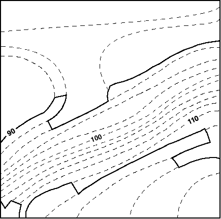
Example:
|
X |
= |
Contour interval in feet |
= |
2 |
= |
8.0 feet |
|
0.25 |
0.25 |
Where: X - distance between contour lines which indicates a slope of 25 percent
In order to calculate the area having a slope equal to or greater than 25 percent, one can use a map with two-foot contour intervals and a scale of one inch equals 20 feet, as shown in the map in this Section. A 25 percent slope, on a map with two-foot contour intervals, is indicated by contour lines that are 8.0 feet apart, rounded to the nearest tenth (0.1) of a foot. On a map whose scale is one inch to 20 feet, 8.0 feet is represented by 0.4 of an inch, rounded to the nearest tenth (0.1) of an inch. Identify where the contour lines are 0.4 of an inch or less apart. Connect these contour lines (as indicated by the heavy lines on the map) and calculate the area.
Caliper (of a tree)
"Caliper" of a tree is the diameter of a tree trunk measured 4 feet, 6 inches from the ground. If a tree splits into multiple trunks below 4 feet, 6 inches from the ground, the trunk is measured at its most narrow point beneath the split.
Critical root zone
The "critical root zone" of a tree is the area containing the roots of a tree that must be maintained and protected to ensure the tree's survival. The area of the critical root zone is measured as one radial foot for every caliper inch of the tree, with a required minimum of four radial feet and maximum of 22 radial feet, measured from the surface of the tree trunk at grade.
Hillside
A "hillside" is ground where the ratio of change in elevation to horizontal distance results in a 10 percent or greater slope or average percent of slope.
Natural feature
A "natural feature" is a specific natural feature belonging to one of the types listed in Section 105-10 (NATURAL FEATURES) and existing within a Special Natural Area District.
Site alteration
A "site alteration" is an alteration on any vacant tract of land, land with minor improvements or any tract of land containing buildings or other structures which includes land contour work, topographic modifications, removal of topsoil, vegetation, excavating, filling, dumping, changes in existing drainage systems, improvements in public rights-of-way, relocation of erratic boulders or modification of any other natural features, whether or not a permit is required from the Department of Buildings, the Department of Transportation or other public agencies.
Staging area
A "staging area" is any area on a zoning lot used during the construction of a development, enlargement or site alteration for the purposes of stockpiling soil or construction materials; storing, cleaning or servicing construction equipment, vehicles or tools; or storing leachable construction products, gases or other materials used to clean or service vehicles, equipment or tools.
Steep slope
A "steep slope" is a portion of a zoning lot with an incline of 25 percent or greater. However, a portion of a zoning lot with an incline of 25 percent or greater shall not be considered a steep slope if it occupies an area of less than 200 square feet or has a dimension of less than 10 feet, measured along the horizontal plane, unless such portions in the aggregate equal 10 percent or more of the area of the zoning lot.
Steep slope buffer
A "steep slope buffer" is a 15-foot wide area having a slope of less than 25 percent that adjoins the entire length of the crest of a steep slope.
Tier I site
A "Tier I site" is a zoning lot or other tract of land having an average percent of slope of less than 10 percent.
Tier II site
A "Tier II site" is a zoning lot or other tract of land having an average percent of slope equal to or greater than 10 percent.
Topsoil
"Topsoil" is soil containing undisturbed humus and organic matter capable of sustaining vigorous plant growth and is generally the top six inches of soil.
Tree credit
A "tree credit" is a credit for preserving an existing tree of six-inch caliper or more that is counted towards a tree preservation requirement or a credit for a newly planted tree of three-inch caliper or more that is counted towards a tree planting requirement.
Tree protection plan
A "tree protection plan" is a plan that modifies the area of no disturbance around a tree proposed for preservation while protecting and preserving the tree during construction. A tree protection plan is prepared by an arborist certified by the International Society of Arborculturists (ISA) or equivalent professional organization that includes:
(a) a survey of the current condition and health of such trees of six-inch caliper or more;
(b) methods for tree protection and preservation based on best management practices, including the prevention of damage due to compaction, grade and drainage pattern changes and tunneling for utilities;
(c) a schedule for site monitoring during construction;
(d) a procedure to communicate protection measures to contractor and workers; and
(e) post-construction treatment.