Waterfront Access Plan Q-1: Northern Hunters Point
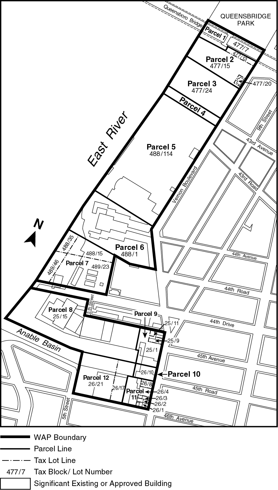
Maps Q-1a through Q-1c in paragraph (f) of this Section show the boundaries of the area comprising the Northern Hunters Point Waterfront Access Plan and the location of certain features mandated or permitted by the Plan. The plan area has been divided into parcels consisting of tax blocks and lots and other lands as established on October 14, 1997, as follows:
Parcel 1: Block 477, Lot 7
Parcel 2: Block 477, Lots 13, 15, 20
Parcel 3: Block 477, Lot 24
Parcel 4: 43rd Avenue between Vernon Boulevard and the East River
Parcel 5: Block 488, Lot 114
Parcel 6: Block 488, Lot 1
Parcel 7: Block 488, Lots 15, 35
Block 489, Lots 23, 46
Parcel 8: Block 25, Lot 15
Parcel 9: Block 25, Lots 1, 9, 11
Parcel 10: Block 26, Lot 10
Parcel 11: Block 26, Lots 1, 2, 3, 4, 8
Parcel 12: Block 26, Lots 17 and 21
(a) Special waterfront yard requirements
The yard regulations of Section 62-33 (Special Yard and Lot Coverage Regulations on Waterfront Blocks) shall be applicable. In addition, where a waterfront yard is not required, pursuant to Section 62-33, yards meeting the dimensional requirements of Section 62-33 shall be provided in connection with any development, in accordance with the provisions of paragraph (f) of Section 62-912 (Elements of a Waterfront Access Plan).
(b) Area-wide modifications
The following provisions shall apply to zoning lots required to provide a waterfront public access area, pursuant to Section 62-50 (GENERAL REQUIREMENTS FOR VISUAL CORRIDORS AND WATERFRONT PUBLIC ACCESS AREAS), inclusive:
(1) Section 62-57 (Requirements for Supplemental Public Access Areas) shall be inapplicable except where specifically stated otherwise in this Plan.
(2) Section 62-58 (Requirements for Water-Dependent Uses and Other Developments) shall be inapplicable. In lieu thereof, for developments listed in Section 62-52 (Applicability of Waterfront Public Access Area Requirements), paragraph (b), required waterfront public access areas shall be provided in accordance with Sections 62-53 (Requirements for Shore Public Walkways), 62-54 (Requirements for Public Access on Piers), 62-55 (Requirements for Public Access on Floating Structures) and 62-56 (Requirements for Upland Connections), as modified by this Plan.
However, for developments that include WD uses and would otherwise be permitted to provide public access pursuant to Section 62-58, the location of the public access areas specified in this Plan may be moved upland from the shoreline for the minimum distance required to accommodate the upland water-dependent functions of such developments, provided the relocation allows for a continuous public walkway connecting to shore public walkways on adjoining zoning lots.
(c) Special waterfront public access area and visual corridor provisions applying on Anable Basin
The following provisions shall apply to certain developments on Parcels 8, 9, 10, 11 and 12:
(1) In the event that a building or other structure, existing at the time that a waterfront public access area is required, is located so that the minimum dimensional provisions of Sections 62-53 and 62-54 cannot be met without requiring the partial or complete demolition of such building or other structure, the required width of such a waterfront public access area shall be reduced to the width between the seaward edge of the waterfront yard or lot line and the existing building or other structure. However, the minimum width of a shore public walkway shall be six feet and that of an upland connection shall be 12 feet. In no case shall a shore public walkway have a width less than 10 feet for a continuous distance of more than 300 feet.
(2) In the event that a building or other structure, existing at the time a waterfront public access area is required, is located so that the minimum dimensional standards for public access pursuant to paragraph (c)(1) of this Section cannot be met without requiring the partial or complete demolition of such building or other structure, all waterfront public access area requirements for such development shall be waived.
(3) A shore public walkway required in conjunction with a development involving existing buildings or other structures, or required on any zoning lot having a shoreline length of less than 150 feet, shall be improved pursuant to Section 62-62 (Design Requirements for Shore Public Walkways and Supplemental Public Access Areas), except that the circulation path as required in paragraph (a)(1) of such Section may be reduced to 10 feet and the amount of planting area as required in paragraph (c)(1) of such Section may be reduced to 40 percent.
(4) Within any portion of a shore public walkway having a width of less than 10 feet, the minimum width of the circulation path shall be six feet and all planting requirements shall be waived.
(d) Special public access provisions by parcel
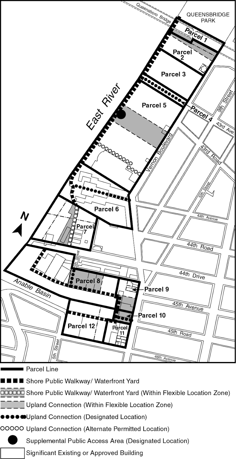
The provisions of Sections 62-52 and 62-60 (DESIGN REQUIREMENTS FOR WATERFRONT PUBLIC ACCESS AREAS), inclusive, are modified at the following designated locations which are shown on Map Q-1b in paragraph (f) of this Section:
(1) Parcel 1
No upland connection shall be required within Parcel 1; however, a direct connection shall be provided between the shore public walkway and Queensbridge Park.
(2) Parcel 2
An upland connection shall be located between Vernon Boulevard and the shore public walkway within the flexible location zone shown on Map Q-1b in paragraph (f) of this Section, which is the westerly prolongation of Queens Plaza South, either:
(i) along the northerly tax lot line of Block 477, Lot 15, and its extension to Vernon Boulevard, if such tax lot is developed as a zoning lot separate from Block 477, Lot 13; or
(ii) continuously adjoining the boundary between Parcels 1 and 2.
(3) Parcel 3
No upland connection shall be required within Parcel 3; however, a direct connection shall be provided between the shore public walkway and the public access area provided on Parcel 4.
(4) Parcel 4
(i) A continuous public access area shall be provided across the westerly termination of 43rd Avenue adjoining the East River and connecting without interruption to the shore public walkways on Parcels 3 and 5. Such waterfront public access area shall have a minimum width of 40 feet and be improved consistent with the design standards set forth in Section 62-62, paragraphs (a) and (c)(1), for a shore public walkway. A screening buffer, pursuant to Section 62-655, shall be provided along any open or enclosed storage areas, maintenance vehicle parking or similar uses adjoining the waterfront public access area. Fencing may be provided to assure physical control of non-publicly accessible upland areas.
(ii) The remaining portion of Parcel 4 shall provide pedestrian access from Vernon Boulevard to the waterfront public access area designated in paragraph (d)(4)(i) of this Section. The New York City Waterfront Symbol with the words "Public Waterfront" shall be installed at the intersection of any pedestrian access area with Vernon Boulevard.
(iii) In the event that 43rd Avenue is demapped as a street within Parcel 4, a shore public walkway and upland connection shall be provided on Parcel 4, pursuant to Sections 62-50 and 62-60, within the westerly prolongation of 43rd Avenue.
Except as otherwise provided in this paragraph (d)(4), Section 62-60 shall be inapplicable.
(5) Parcel 5
(i) Upland connection
An upland connection shall be provided through Parcel 5 between Vernon Boulevard and the shore public walkway. The upland connection shall be located within either:
(a) the flexible location zone indicated on Map Q-1b in paragraph (f) of this Section, having as its southerly boundary a line 500 feet south of 43rd Avenue and as its northerly boundary a line 200 feet north of such southerly boundary; or
(b) a raised pedestrian sidewalk immediately adjoining a building provided both the sidewalk and building were existing on October 14, 1997.
The requirements of Sections 62-561 (Types of upland connections) and 62-64 (Design Requirements for Upland Connections) shall be inapplicable; however, any vehicular way traversing the pedestrian sidewalk shall be at the same level as such raised pedestrian sidewalk.
A direct connection shall be provided between the shore public walkway and the public access areas on Parcels 4 and 6.
(ii) Supplemental public access area
Notwithstanding paragraph (b)(1) of this Section, a supplemental public access area shall be provided pursuant to Sections 62-57 and 62-62, and shall be located within the flexible location zone described in paragraph (d)(5)(i) of this Section, immediately adjacent to the intersection of the shore public walkway and any upland connection, if the upland connection is located therein.
(6) Parcel 6
Sections 62-50 and 62-60 shall be inapplicable if public access is provided pursuant to restrictive declaration, number D-138, executed by the RAK Tennis Corporation on July 29, 1991, and as such may be modified pursuant to the terms of the declaration and in accordance with Section 62-12 (Applicability to Developments in the Waterfront Area). If public access is not provided pursuant to the declaration, as such may be modified, then a waterfront public access area shall be provided in accordance with Sections 62-50, as modified by paragraph (b) of this Section, and Section 62-60.
(7) Parcel 7
(i) Shore public walkway
The shore public walkway shall be located within the flexible location zone shown on Map Q-1b in paragraph (f) of this Section, having as its westerly boundary the seaward edge of the waterfront yard and as its easterly boundary a line perpendicular to the northerly street line of 44th Drive, 600 feet westerly of Vernon Boulevard. The area between the seaward edge of the waterfront yard and the shore public walkway shall be subject to the provisions of Section 62-332 (Rear yards and waterfront yards).
For developments on a zoning lot having a building or other structure, existing on October 14, 1997, and which developments would retain the existing building or other structure, any portion of which is located within the waterfront yard, the shore public walkway may be improved pursuant to Section 62, except that the circulation path as required in paragraph (a)(1) of such Section may be reduced to 10 feet and the planting area as required in paragraph (c)(1) of such Section may be reduced to 40 percent. In addition, any portion of the shore public walkway located on a platform existing on October 14, 1997, shall be exempt from the planting requirements of such Section, except that trees shall be required; however, such trees may be located off the platform anywhere within or immediately adjoining the shore public walkway.
(ii) Upland connection
No upland connection shall be required within Parcel 7.
(8) Parcel 8
An upland connection shall be provided through Parcel 8 and shall be located within the flexible location zone shown on Map Q-1b in paragraph (f) of this Section, having as its westerly boundary the westerly street line of 5th Street and as its easterly boundary a line 250 feet east of such street line. In the event that a building or other structure, existing at the time an upland connection is required, is located within the southerly prolongation of 5th Street, the upland connection may be located anywhere within the flexible location zone; otherwise, the upland connection shall be located within the southerly prolongation of 5th Street.
(9) Parcels 9, 10 and 11
(i) Shore public walkway
Except as provided in paragraph (c) of this Section, a shore public walkway shall be required across each parcel; however, on any zoning lot existing on October 14, 1997, having a shoreline length of less than 150 feet, the width of the shore public walkway may be reduced to 16 feet, consisting of a 10 foot wide circulation path and six foot wide screening buffer, pursuant to Section 62-655. In addition, the width may be further reduced as permitted pursuant to paragraph (c)(1) of this Section.
(ii) Upland connection
Except as provided in paragraph (c) of this Section and on any zoning lot with a shoreline length less than 100 feet, an upland connection shall be provided between Vernon Boulevard and the shore public walkway within the flexible location zone shown on Map Q-1b, having as its northerly boundary the westerly prolongation of the southerly street line of 45th Avenue and as its southerly boundary the westerly prolongation of the southerly street line of 45th Road. In the event that Parcels 10 and 11 are developed as a single zoning lot and the upland connection has not been provided prior to such development of Parcels 10 and 11, the upland connection shall be located within the westerly prolongation of 45th Road. Notwithstanding the requirements of Section 62-56 (Requirements for Upland Connections), on any zoning lot having a shoreline length of less than 150 feet, the required width of an upland connection may be reduced to 16 feet consisting of a 10 foot wide circulation path with the remaining area to be planted. In addition, the width may be further reduced, as permitted pursuant to paragraph (c)(1) of this Section.
(10) Parcel 12
No upland connection shall be required within Parcel 12; however, a direct connection shall be provided between the shore public walkway and 5th Street.
(e) Special visual corridor provisions by parcel
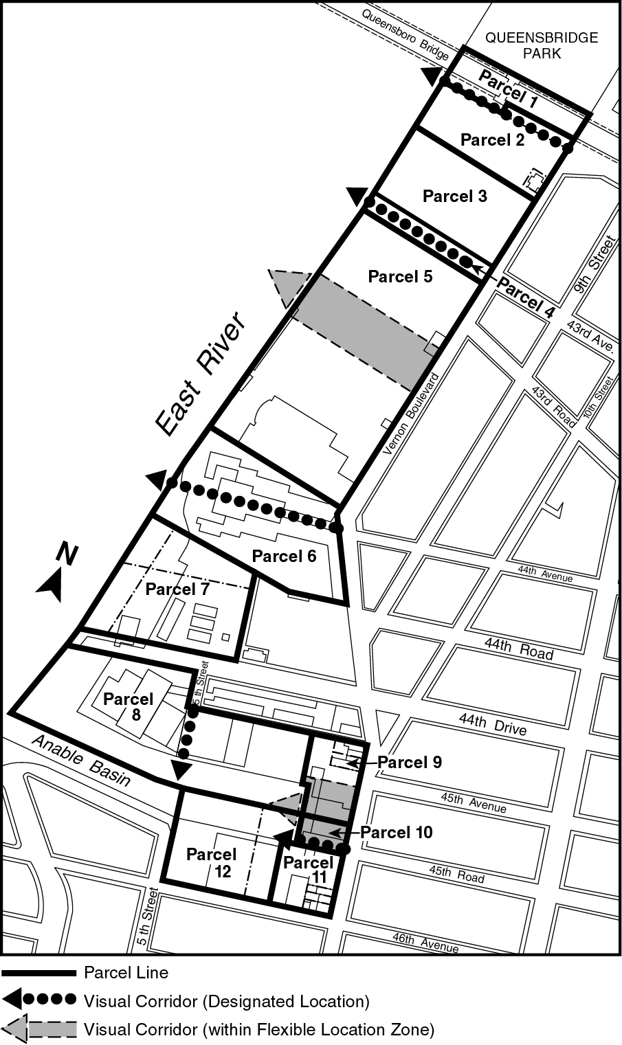
The designated locations for visual corridors pursuant to this Plan shall be as follows and are shown on Map Q-1c in paragraph (f) of this Section:
(1) Parcels 1 and 2
A visual corridor shall be provided through Parcels 1 and 2 to the pierhead line as the westerly prolongation of Queens Plaza South. In the event that Block 477, Lot 13, is developed as a single zoning lot, all visual corridor requirements on that lot shall be waived.
(2) Parcel 3
The requirement for visual corridors on Parcel 3 is waived.
(3) Parcel 4
43rd Avenue shall be provided as a visual corridor.
(4) Parcel 5
A visual corridor shall be provided through Parcel 5 to the pierhead line within the flexible location zone described in paragraph (d)(5)(ii) of this Section and coincident with any upland connection provided therein.
(5) Parcel 6
Sections 62-51 (Applicability of Visual Corridor Requirements) and 62-513 (Permitted obstructions in visual corridors) shall be inapplicable if a visual corridor is provided pursuant to restrictive declaration, number D-138, executed by the RAK Tennis Corporation on July 29, 1991, and as may subsequently be modified pursuant to the terms of the declaration and in accordance with Section 62-12 (Applicability to Developments in the Waterfront Area). If the visual corridor is not provided pursuant to the declaration, as such may be modified, then a visual corridor shall be provided in accordance with Section 62-51.
(6) Parcel 7
The requirement for visual corridors on Parcel 7 is waived.
(7) Parcel 8
A visual corridor shall be provided through Parcel 8 as the southerly prolongation of 5th Street.
(8) Parcels 9, 10 and 11
A visual corridor, if required pursuant to Section 62-51, shall be located through Parcel 9, 10 or 11 from Vernon Boulevard using the locational criteria for, and coincident with, the upland connection required pursuant to paragraph (d)(9)(ii) of this Section.
(9) Parcel 12
The requirement for visual corridors on Parcel 12 is waived.
(f) Northern Hunters Point Waterfront Access Plan Maps
Q-1a: Parcel Designation (62-951f.1)
Q-1b: Public Access Elements Designation (62-951f.2)
Q-1c: Designated Visual Corridors Designation (62-951f.3)