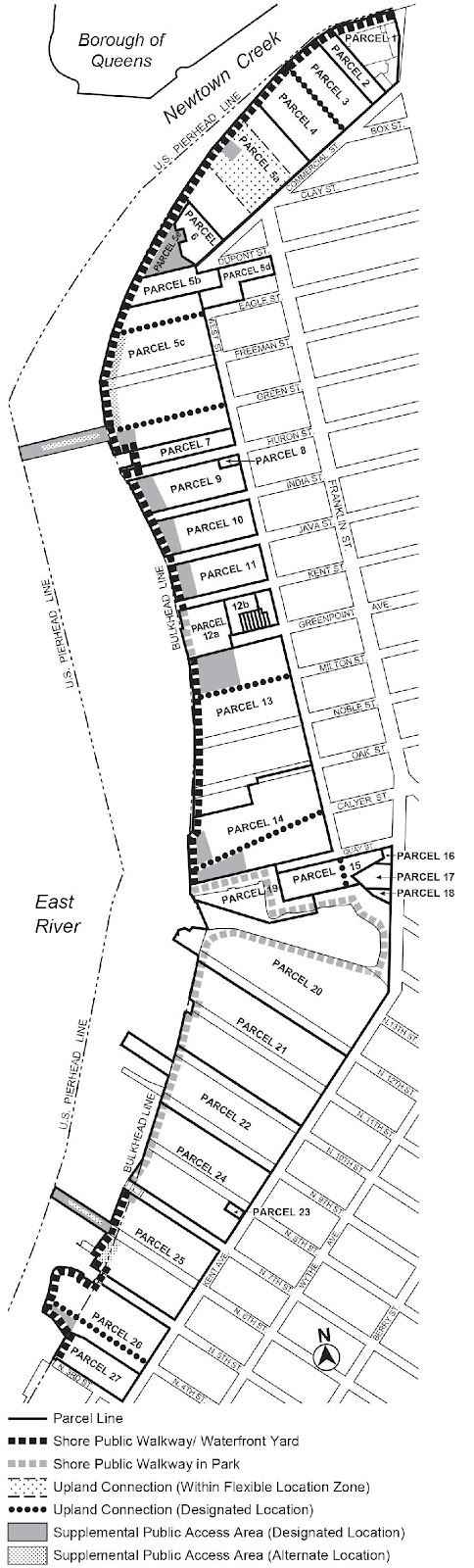
Waterfront Access Plan BK-1: Greenpoint-Williamsburg
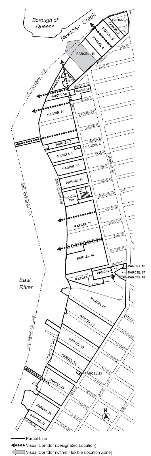
Maps BK-1a through BK-1c in paragraph (f) of this Section show the boundaries of the area comprising the Greenpoint-Williamsburg Waterfront Access Plan and the location of certain features mandated or permitted by the Plan. The plan area has been divided into parcels consisting of tax blocks and lots and other lands as established on May 11, 2005, as follows:
Parcel 1: Block 2472, Lot 350
Parcel 2: Block 2472, Lot 400
Parcel 3: Block 2472, Lot 410
Parcel 4: Block 2472, Lot 425
Parcel 5a: Block 2472, Lot 100
Parcel 5b: Block 2472, Lot 32, south of the prolongation of the northern street line of DuPont Street
Block 2494, Lot 6
Parcel 5c: Block 2472, Lot 2
Block 2502, Lot 1
Block 2510, Lot 1
Block 2520, Lot 57
Parcel 5d: Block 2494, Lot 1
Parcel 5e: Block 2472, Lot 32, north of the prolongation of the northern street line of DuPont Street
Parcel 6: Block 2472, Lot 75
Parcel 7: Block 2520, Lot 1
Parcel 8: Block 2530, Lots 55, 56
Parcel 9: Block 2530, Lot 1
Parcel 10: Block 2538, Lot 1
Parcel 11: Block 2543, Lot 1
Parcel 12a: Block 2556, Lot 41
Parcel 12b: Block 2556, Lots 45, 46
Parcel 12c: Block 2556, Lots 55, 57, 58
Parcel 12d: Block 2556, Lot 54
Parcel 12e: Block 2556, Lot 53
Parcel 12f: Block 2556, Lot 52
Parcel 12g: Block 2556, Lot 51
Parcel 12h: Block 2556, Lot 50
Parcel 12i: Block 2556, Lot 49
Parcel 12j: Block 2556, Lot 48
Parcel 13: Block 2556, Lot 1
Block 2564, Lot 1
Block 2567, Lot 1
Block 2570, Lot 36
Parcel 14: Block 2570, Lot 1
Parcel 15: Block 2590, Lot 1
Parcel 16: Block 2590, Lot 210
Parcel 17: Block 2590, Lot 215
Parcel 18: Block 2590, Lot 22
Parcel 19: Block 2590, Lot 25
Parcel 20: Block 2277, Lot 1
Block 2590, Lot 100
Parcel 21: Block 2287, Lots 1, 16, 30
Block 2294, Lots 1, 5
Parcel 22: Block 2301, Lots 1, 50, 60, 70
Parcel 23: Block 2316, Lot 46
Parcel 24: Block 2308, Lot 1
Block 2316, Lot 1
Parcel 25: Block 2324, Lot 1
Block 2332, Lot 1
Parcel 26: Block 2340, Lot 1
Parcel 27: Block 2348, Lot 1
(a) Area-wide modifications
The following provisions shall apply to all developments required to provide a waterfront public access area, pursuant to Section 62-50 (GENERAL REQUIREMENTS FOR VISUAL CORRIDORS AND WATERFRONT PUBLIC ACCESS AREAS):
(1) Paragraph (a)(3) of Section 62-54 (Requirements for Public Access on Piers) is applicable, except that a minimum of 15 feet is required along each water edge.
(2) In addition to the requirements of Section 62-65 (Public Access Design Reference Standards), all waterfront public access areas are subject to the provisions set forth in paragraph (c) of this Section.
(3) Street treatment
All streets adjacent to a shore public walkway or supplemental public access area shall be improved as a continuation of such shore public walkway or supplemental public access area, pursuant to the design requirements of Section 62-62 (Design Requirements for Shore Public Walkways and Supplemental Public Access Areas), inclusive.
(b) Amenities
A reduction in the total amount of required supplemental public access area shall be permitted according to the table in this paragraph, (b):
REDUCTIONS IN WATERFRONT PUBLIC ACCESS AREAS
Amenity | Square feet reduction |
Picnic table | 22 sq. ft. per table (max. 200 sq. ft.) |
Chess table | 20 sq. ft. per table (max. 200 sq. ft.) |
Telescope | 10 sq. ft. per telescope (max. 50 sq. ft.) |
Fountain/water feature | 150 sq. ft. per feature (max. 300 sq. ft.) |
Shade structure | 150 sq. ft. per structure (max. 300 sq. ft.) |
(c) Public access design reference standards
Section 62-65 is hereby modified by the following provisions.
(1) Guardrails
In addition to the provisions of paragraph (a) of Section 62-651 (Guardrails, gates and other protective barriers), guardrails shall comply with the Guardrail illustration in this Section.
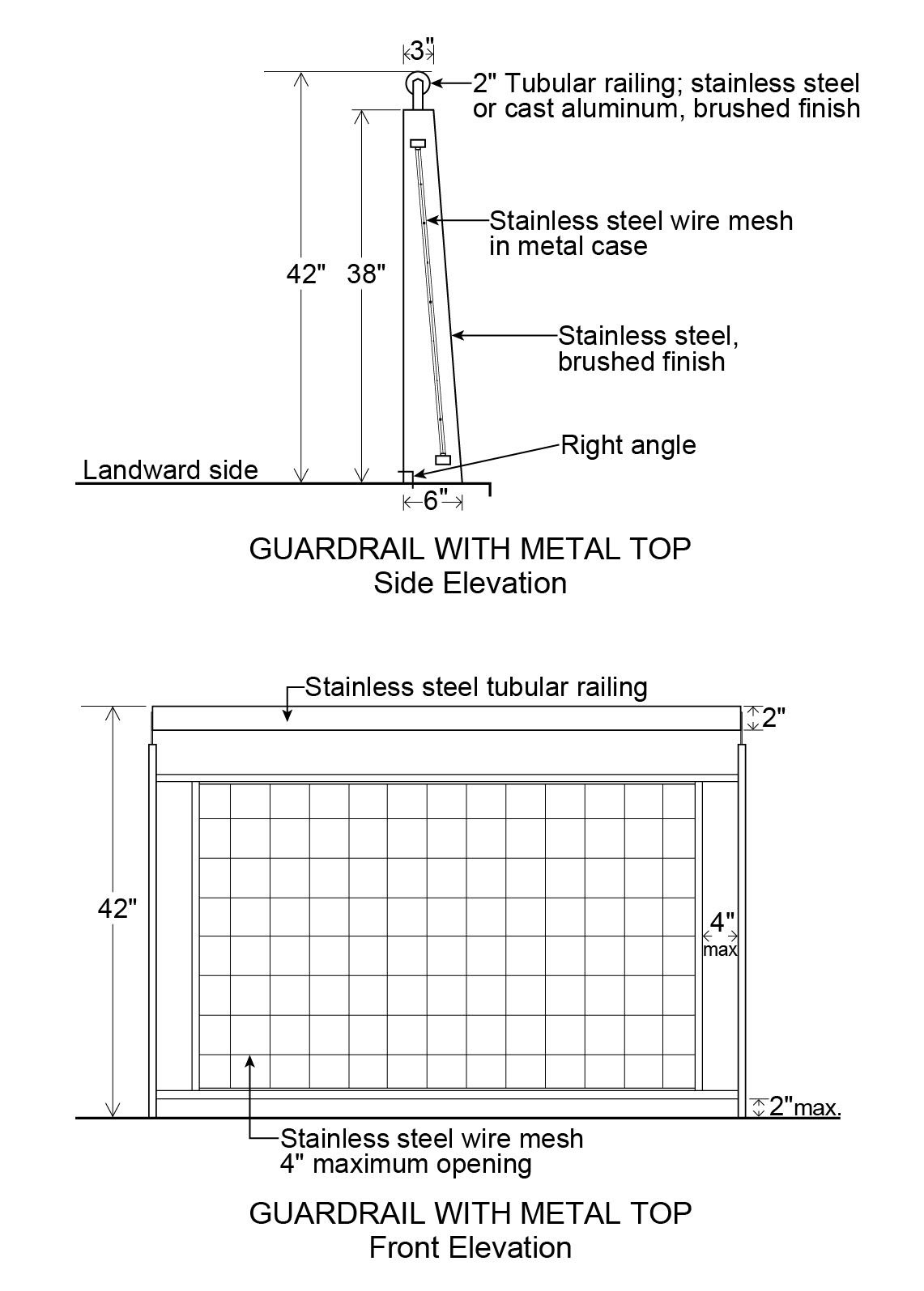
All guardrail components and hardware shall be in No. 316 Stainless Steel, passivated and bead blasted.
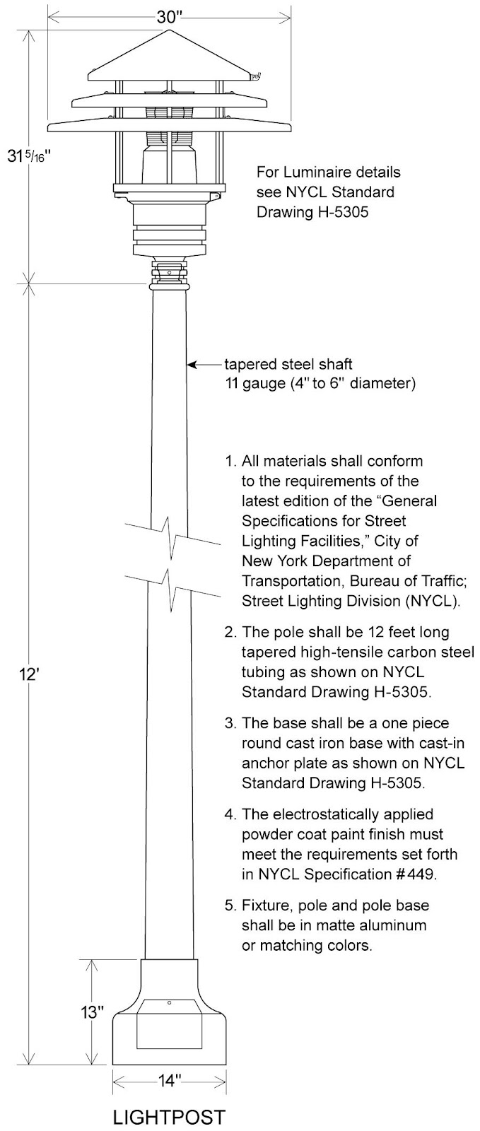
(2) Lighting
In addition to the illumination provisions of Section 62-653, the required lighting along any public access area shall comply with the Lightpost illustration in this Section.
(3) Paving
In addition to the provisions of Section 62-656, the paving for the required clear path within the shore public walkway shall be gray. At least 50 percent of all other paved areas within the shore public walkway and supplemental public access areas shall be paved in the same color range.
(d) Special public access provisions by parcel
The provisions of Sections 62-52 (Applicability of Waterfront Public Access Area Requirements) and 62-60 (DESIGN REQUIREMENTS FOR WATERFRONT PUBLIC ACCESS AREAS) are modified at the following designated locations which are shown on Map BK-1b in paragraph (f) of this Section:
(1) Parcels 1 and 2
(i) Shore public walkway
In the event of any enlargement, extension or change of use within existing buildings or other structures, a shore public walkway shall occupy the entire area between the seaward edge of the zoning lot and the existing building or other structure but need not be wider than 40 feet. The shore public walkway shall have a minimum clear path of 10 feet. No seating or planting shall be required. If seating and planting are provided, they shall comply with the provisions of Sections 62-652 and 62-655, respectively. In addition to the lighting design requirements of paragraph (c)(3) of this Section, lighting fixtures may be mounted on existing buildings or other structures.
(ii) Supplemental public access area
The requirements for a supplemental public access area shall be waived.
(2) Parcels 3 and 4
An upland connection shall be provided between Commercial Street and the shore public walkway within a flexible location along the lot line between Parcels 3 and 4. Whichever parcel is developed first shall provide an upland connection along the lot line between the two parcels. The remaining parcel may include the width of the upland connection in the computation necessary to comply with the requirements of a visual corridor along the lot line between the two parcels, according to the provisions of paragraph (e)(1) of this Section. If both parcels are developed concurrently, then the requirements may be divided equally along the lot line between the parcels.
If, however, Parcel 4 is improved predominantly as a public access area prior to or concurrently with the development of Parcel 3, the upland connection requirement shall be waived. However, a public way shall be provided within an area bounded at its eastern edge by the shared lot line of Parcels 2 and 3, at its northern edge by the shoreline, at its western edge by a line 115 feet from the shared lot line of Parcels 2 and 3, and at its southern edge by the lot line along Commercial Street.
In addition, such public way shall have a minimum width of 15 feet, and shall comply with the provisions of Section 62-64 (Design Requirements for Upland Connections), as applicable for Type 2 upland connections. There shall be no more than two changes in direction over its entire length and no single turn shall be less than 90 degrees relative to the line of travel. Any change in direction with an angle of less than 135 degrees shall be posted with an entry sign and shall comply with the provisions of paragraph (b) of Section 62-654 (Signage), and shall also be accompanied by an arrow indicating the direction of travel towards the shore public walkway. At least 50 percent of the area of any walls bounding such public way shall be glazed. In addition, 24 linear feet of seating shall be provided within such public way and within 50 feet of its boundary with the shore public walkway and the street it connects to.
(3) Parcel 5a
(i) Upland connection
An upland connection shall be provided between Commercial Street and the shore public walkway within the flexible location zone indicated on Map BK-1b in paragraph (f) of this Section.
The eastern boundary of such flexible location zone shall be 110 feet from the shared lot line of Parcel 4 and its western boundary shall be 200 feet from the shared lot lines of Parcels 5b and 6.
(ii) Supplemental public access area
The supplemental public access area shall abut the shore public walkway continuously along its longest side, and shall also abut the required upland connection where it meets the shore public walkway. The upland connection may cut across the supplemental public access area provided that any resulting supplemental public access area shall be at least 5,000 square feet. In no event shall the supplemental public access area be deeper than 100 feet.
Alternatively, a portion of the required supplemental public access area that is at least 5,000 square feet may abut the shore public walkway continuously along the longest side provided that it also abuts a publicly accessible private drive connecting the shore public walkway to Commercial Street. Such publicly accessible private drive shall be improved to the standards of an upland connection as required by Section 62-64, but shall not be counted towards satisfying the required amount of waterfront public access area on the site.
(4) Parcel 5b
The portion of Block 2472, Lot 32, located within Parcel 5b shall constitute a zoning lot for the purpose of applying all waterfront public access area and visual corridor provisions of Sections 62-50 through 62-90 (WATERFRONT ACCESS PLANS), inclusive.
(5) Parcel 5c
(i) Upland connection
Two upland connections shall be provided between West Street and the shore public walkway, each one located within the prolongation of the street lines of Eagle Street and Green Street, respectively.
(ii) Supplemental public access area
Two supplemental public access areas shall be provided on Parcel 5c.
A supplemental public access area shall be bounded by the southern boundary of the required Green Street upland connection, the shore public walkway, the southern boundary of Parcel 5c and the northern prolongation of the eastern boundary of the shore public walkway required in Parcel 7.
The remaining required supplemental public access area shall be provided either on the pier or distributed evenly as a widening of the shore public walkway located between the Eagle Street and Green Street upland connections. If any supplemental public access area is located on the pier, one shade tree shall be required for each 1,000 square feet of supplemental public access area, but in no event shall more than four shade trees be required. A shading element may be substituted for the required shade trees at a rate of 450 square feet of shade element per tree.
The total lot area utilized in the calculation of required supplemental public access area for Parcel 5c, pursuant to Section 62-57, shall include the lot area within Parcel 5d.
(iii) Pier public access
Public access shall be provided on the Green Street pier pursuant to the requirements of Section 62-54 and of paragraph (a)(1) of this Section.
(6) Parcel 5e
The portion of Block 2472, Lot 32, located within Parcel 5e shall constitute a zoning lot for the purpose of applying all waterfront public access area and visual corridor provisions of Sections 62-50 through 62-90, inclusive.
(7) Parcel 7
(i) Shore public walkway
For a portion of the required shore public walkway, where the distance between the shoreline and the zoning lot line boundaries of Parcel 7 is less than 17 feet, such portion shall be improved entirely as circulation path.
(ii) Supplemental public access area
The requirement for a supplemental public access area on Parcel 7 is waived.
(8) Parcels 9, 10 and 11
(i) Supplemental public access area
For each parcel, the supplemental public access area requirements shall be provided to widen the shore public walkway, which will be evenly distributed along the entire length of such shore public walkway.
(9) Parcel 13
(i) Upland connection
An upland connection shall be provided between West Street and the shore public walkway located within the prolongation of the street lines of Milton Street.
(ii) Supplemental public access area
A supplemental public access area shall be bounded by the southern street line of Greenpoint Avenue, the shore public walkway and the northern boundary of the required Milton Street upland connection.
(10) Parcel 14
(i) Upland connection
An upland connection shall be provided between West Street and the shore public walkway. The southern boundary of such upland connection shall be defined by a line between the intersection of the prolongation of the southern street line of Calyer Street and the western street line of West Street, and a point on the easterly boundary of the shore public walkway 30 feet north of the northern street line of Quay Street.
(ii) Supplemental public access area
Two supplemental public access areas shall be provided. A supplemental public access area with a minimum of 9,000 square feet shall be provided between the prolongation of the northern street line of Calyer Street and the prolongation of the northern boundary of the required Calyer Street upland connection to widen the shore public walkway.
The remaining requirements for supplemental public access area shall be located in the area bounded by the southern boundary of the required Calyer Street upland connection, the shore public walkway and the southern boundary line of the parcel.
(11) Parcel 15
An upland connection shall be provided within the prolongation of the street lines of West Street, connecting Quay Street to Parcel 20.
(12) Parcels 19, 20, 21 and 22
Parcels 19, 20, 21 and 22 shall be designated as public parks as of May 11, 2005.
(13) Parcel 25
(i) Upland connection
An upland connection shall be provided between West Street and the shore public walkway located within the prolongation of the street lines of North 6th Street.
(ii) Supplemental public access area
Two supplemental public access areas shall be provided.
One supplemental public access area shall be provided along the prolongation of the southern street line of North 7th Street and the shore public walkway. Such public access area shall be a minimum of 3,000 square feet in area and shall have a minimum depth of 90 feet measured from the shore public walkway. A screening buffer shall be provided along the boundaries of the public access area and any private portion of the zoning lot, pursuant to Section 62-655. No other planting shall be required.
A minimum of one linear foot of seating shall be required for every 65 square feet of supplemental public access area. Four trees shall be required, at least two of which shall be shade trees.
The remaining required supplemental public access area shall be located either on the pier or shall abut the shore public walkway continuously along its longest side, and shall also abut the required upland connection where it meets the shore public walkway. At least 70 percent of the required supplemental public access area shall have a width to depth ratio of 2:1. If any supplemental public access area is located on the pier, one shade tree shall be required for each 1,000 square feet of supplemental public access area, but in no event shall more than four shade trees be required. A shading element may be substituted for the required shade trees at a rate of 450 square feet of shade element per tree.
(iii) Pier public access
Public access shall be provided on a pier located at the western terminus of North 6th Street pursuant to the requirements of Section 62-54 and of paragraph (a)(1) of this Section.
(14) Parcel 26
(i) Shore public walkway
The requirements of Section 62-53 (Requirements for Shore Public Walkways) shall apply, except that the minimum required width of the shore public walkway shall be reduced to 34 feet between North 5th Street and the northern boundary of the required upland connection at the prolongation of North 4th Street. The quantity of public access eliminated from the shore public walkway as a result of this width reduction shall be located in the triangle formed between the shore public walkway, the southern street line of the North 4th Street upland connection and the bulkhead line.
(ii) Upland connections
An upland connection shall be provided between Kent Avenue and the shore public walkway located within the prolongation of the street lines of North 4th Street. However, if the upland connection is provided within a private drive pursuant to Section 62-56, then a portion of the southern public access area beyond 15 feet from Kent Avenue may be located up to 15 feet outside the prolongation of the street lines of North 4th Street, provided that this public access area is not located entirely outside the prolongation of the street lines of North 4th Street at any point within 80 feet of Kent Avenue.
(15) Parcel 27
(i) Shore public walkway
In the event of an enlargement, extension or change of use within existing buildings or other structures, a shore public walkway shall occupy the entire area between the seaward edge and the existing building or other structure, but need not be wider than 40 feet.
Notwithstanding the requirements of paragraph (a) of Section 62-61 (General Provisions Applying to Waterfront Public Access Areas), the shore public walkway may be located within the building or other structure, and the obstructions permitted by Section 62-611, paragraphs (a) and (b), shall include any supporting structural elements of the building or other structure and its related appurtenances.
In addition, the shore public walkway shall have a minimum clear path of 12 feet. No seating, planting or buffer zone shall be required. If seating and planting are provided, they shall comply with the provisions of Sections 62-652 and 62-655, respectively. In addition to the lighting design requirements of paragraph (c)(3) of this Section, lighting fixtures may be mounted on existing buildings or other structures.
(ii) Supplemental public access area
The requirements for supplemental public access shall be waived.
(e) Special visual corridor provisions by parcel
The designated locations for visual corridors pursuant to this Plan are shown on Map BK-1c in paragraph (f) of this Section and shall be as follows:
(1) Parcels 3 and 4
A visual corridor shall be provided through Parcels 3 and 4 to the pierhead line within a flexible area along the common lot line.
Whichever parcel is developed later shall complete the required clearance to comply with the visual corridor requirements along the upland connection provided in accordance with the requirements of paragraph (d)(2)(i) of this Section. If the parcels are developed concurrently, then the requirements can be divided equally along the lot line between the parcels.
If, however, Parcel 4 is improved predominantly for a public access area(s) prior to or concurrently with the development of Parcel 3, and a visual corridor is provided in Parcel 4, then the requirements for a visual corridor on Parcel 3 shall be waived.
(2) Parcel 5a
A visual corridor shall be provided through Parcel 5a to the pierhead line within the flexible location zone indicated on Map BK-1c in paragraph (f) of this Section. The eastern boundary of such flexible area shall be 110 feet from the shared lot line of Parcel 4 and its western boundary shall be 200 feet from the shared lot line of Parcels 5b and 6.
(3) Parcel 5b
Two visual corridors shall be provided through Parcel 5b to the pierhead line as the prolongation of the street lines of West Street and Dupont Street, respectively.
(4) Parcel 5c
(i) Three visual corridors shall be provided through Parcel 5c to the pierhead line as the prolongation of the street lines of West Street, Eagle Street and Green Street.
(ii) The permitted obstructions on piers in Section 62-631, paragraph (b), shall be permitted obstructions along the visual corridor along Green Street.
(5) Parcel 13
Two visual corridors shall be provided through Parcel 13 to the pierhead line as the prolongation of the street lines of Milton Street and Oak Street, respectively.
(6) Parcel 14
A visual corridor shall be provided through Parcel 14 as the prolongation of the street lines of Oak Street.
(7) Parcel 15
A visual corridor shall be provided though Parcel 15 as the prolongation of the street lines of West Street.
(8) Parcel 25
A visual corridor shall be provided through Parcel 25 as the prolongation of the street lines of North 6th Street.
(f) Greenpoint-Williamsburg Waterfront Access Plan Maps
BK-1a: Parcel Designation (62-931f.1)
BK-1b: Public Access Elements (62-931f.2)
BK-1c: Designated Visual Corridors (62-931f.3)