Definitions
Definitions specially applicable to this Chapter are set forth in this Section. The definitions of other defined terms are set forth in Section 12-10 (DEFINITIONS) and Section 64-11 (Definitions).
Development
For the purposes of this Chapter, a “development” shall also include:
(a) an enlargement;
(b) any alteration that increases the height or coverage of an existing building or other structure;
(c) an extension; or
(d) a change of use from one Use Group to another, or from one use to another in the same Use Group, or from one use listed in Section 62-21 (Classification of Uses in the Waterfront Area) to another such use.
However, a development shall not include incidental modifications to a zoning lot, including but not limited to, the addition of deployable flood control measures and any associated permanent fixtures, the addition of temporary structures such as trash receptacles, food carts or kiosks, and the incorporation of minor permanent structures such as light stanchions, bollards, fences, or structural landscaped berms and any associated flood gates. All such modifications shall remain subject to any associated permitted obstruction allowances, as applicable.
Furthermore, a development shall not include the exclusive addition of energy infrastructure equipment, accessory mechanical equipment, electric vehicle charging facilities, as a primary or accessory use, or qualifying exterior wall thickness, whether added to a building or to an open area of the zoning lot.
Floating structure
A “floating structure” is any vessel, barge or other water-supported structure, other than a floating dock accessory to a WD use, which is bounded by either open water, a dock or the lot lines of a zoning lot, and that is permanently moored or otherwise attached to a pier, wharf, dock, platform, bulkhead or flotation system for a period of more than 180 consecutive days. Support by means of a cradle or as a result of natural siltation shall not exempt a normally water-supported structure from this definition.
Any water-supported structure, other than a navigational vessel, docked for not more than 180 consecutive days for a purpose other than navigation or accessory to a WD use, shall be deemed to be a "temporary floating structure." Such temporary floating structures shall only be permitted subject to the approval of the Commissioner of Buildings or Business Services, as applicable.
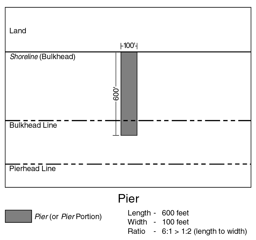
Pier
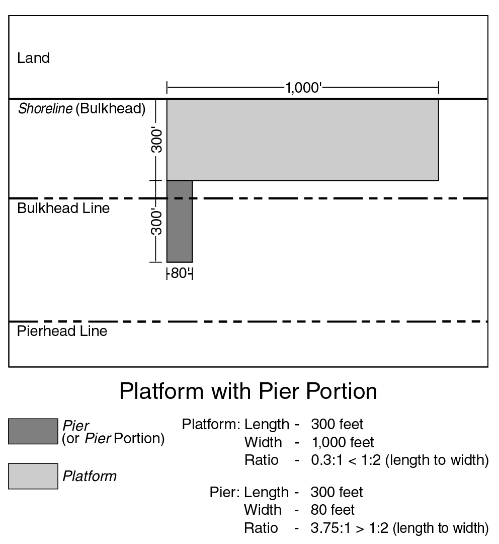
A “pier” is a structure at the water's edge, not otherwise defined as a platform, that is:
(a) a pile-supported overwater structure, or a portion thereof, that projects from a shoreline, bulkhead or platform; or
(b) a solid-core structure, or a portion thereof, constructed for the docking of water-borne vessels, that projects from the land or from a platform.
Projections from platforms shall be considered piers if their length, measured from the portion of the platform from which they project, exceeds 50 percent of their width at such portion. Any further extensions from such projections shall be considered piers regardless of their configuration.
(62 - 11.1)
Pier, existing
An “existing pier” is a pier where at least 75 percent of its surface is visible in the April 1988 Lockwood, Kessler and Bartlett aerial photographs of New York City.
Pier, new
A “new pier” is any pier other than an existing pier.
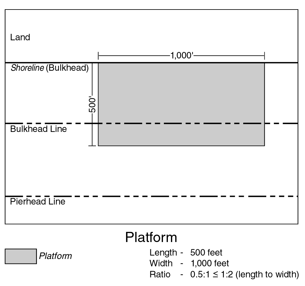
Platform
A “platform” is a pile-supported or solid-core structure at the water's edge, or a portion thereof, that:
(a) is permanently connected to the land; and
(b) has a seaward dimension that does not exceed 50 percent of its dimension along the land to which it is connected.
(62 - 11.2)
(62 - 11.3)
Platform, existing
An “existing platform” is a platform where at least 75 percent of its surface is visible in the April 1988 Lockwood, Kessler and Bartlett aerial photographs of New York City.
Platform, new
A “new platform” is any platform other than an existing platform.
Predominant or predominantly
“Predominant” or “predominantly” shall mean that a use or a group of uses comprises at least 75 percent of the total floor area of the building or on the zoning lot or, in the case of open uses, the lot area or pier water coverage, as applicable.
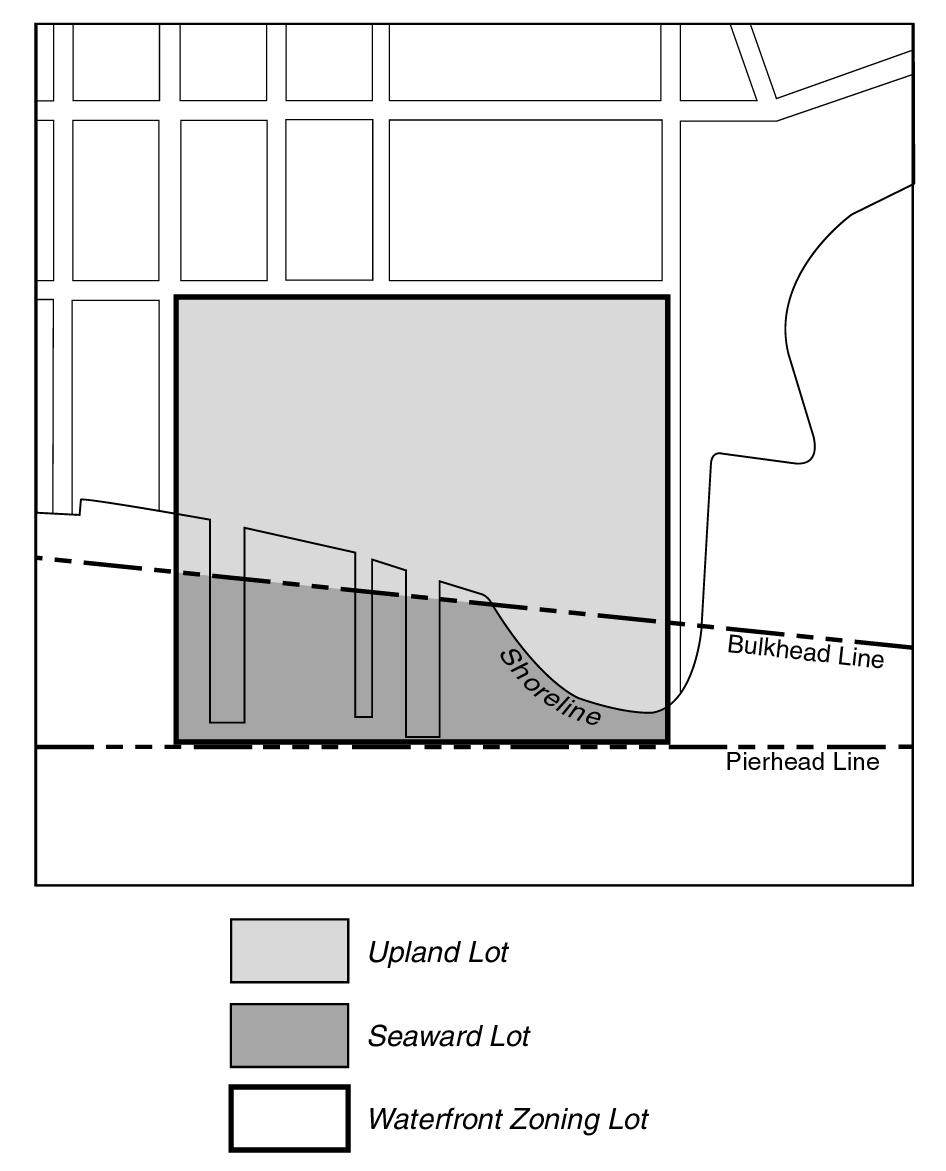
Seaward lot
A “seaward lot” is the portion of a waterfront zoning lot located seaward of the bulkhead line, except for any land above water included as part of the upland lot.
SEAWARD/UPLAND LOTS
(62 - 11.4)
Shore public walkway
A “shore public walkway” is a linear public access area running alongside the shore or water edges of a platform on a waterfront zoning lot.
Supplemental public access area
A “supplemental public access area” is a public access area provided on a waterfront zoning lot, in addition to other required public access areas, in order to fulfill the required waterfront public access area requirements. A supplemental public access area shall not include a shore public walkway or an upland connection.
Tidal wetland area
A “tidal wetland area” is an area planted with species tolerant of saline water inundation that is located between the mean low water line and the landward edge of the stabilized natural shore or bulkhead. Such area may be used to satisfy requirements for waterfront yards, shore public walkways and planting in this Chapter.
Upland connection
An “upland connection” is a pedestrian way which provides a public access route from a shore public walkway to a public sidewalk within an open and accessible street, public park or other accessible public place.
Upland lot
An “upland lot” is the portion of a waterfront zoning lot located landward of the bulkhead line. Where a portion of the shoreline projects seaward of the bulkhead line, such land above water shall be included as part of the upland lot (see illustration of Seaward/Upland Lots).
Visual corridor
A “visual corridor” is a public street or open area within one or more zoning lots that provides a direct and unobstructed view to the water from a vantage point within a public street, public park or other public place.
Water coverage
“Water coverage” is the portion of a zoning lot seaward of the shoreline that, when viewed directly from above, would be covered by a pier, platform or floating structure, including portions of buildings or other structures projecting over the water from such structures. Water coverage shall not include docking or navigational appurtenances which may project from the aforementioned structures.
Waterfront block or waterfront zoning lot
A “waterfront block” or "waterfront zoning lot” is a block or zoning lot in the waterfront area having a boundary at grade coincident with or seaward of the shoreline. For the purposes of this Chapter:
(a) a block within the waterfront area shall include the land within a street that is not improved or open to the public, and such street shall not form the boundary of a block;
(b) a block within the waterfront area that abuts a public park along the waterfront shall be deemed to be part of a waterfront block; and
(c) a zoning lot shall include the land within any street that is not improved or open to the public and which is in the same ownership as that of any contiguous land.
However, any block or zoning lot in the waterfront area having a boundary within or coincident with the boundaries of the Gowanus Canal, as shown on the City Map, shall be a waterfront block or waterfront zoning lot, respectively.
Any zoning lot, the boundaries of which were established prior to November 1, 1993, and which is not closer than 1,200 feet from the shoreline at any point and which does not abut a public park along the waterfront, shall be deemed outside of the waterfront block.
Waterfront public access area
A “waterfront public access area” is the portion of a zoning lot improved for public access. It may include any of the following: a shore public walkway, upland connection, supplemental public access area or public access area on a pier or floating structure.
Waterfront yard
A “waterfront yard” is that portion of a waterfront zoning lot extending open and unobstructed from the lowest level to the sky along the entire length of the shoreline, stabilized natural shore, bulkhead or water edge of a platform, as applicable, for a depth or width as set forth in this Chapter.