Chapter 2 - Construction of Language and Definitions
The following rules of construction apply to the text of this Resolution:
(a) The particular shall control the general.
(b) In case of any difference of meaning or implication between the text of this Resolution and any caption, illustration, summary table or illustrative table, the text shall control.
(c) The word "shall" is always mandatory and not discretionary. The word "may" is permissive.
(d) Words used in the present tense shall include the future; and words used in the singular number shall include the plural, and the plural the singular, unless the context clearly indicates the contrary.
(e) A "building" or "structure" includes any part thereof. The terms residential building, commercial building and community facility building shall refer to an entire building used exclusively for such use.
(f) The phrase "used for" includes "arranged for", "designed for", "intended for", "maintained for", "or occupied for".
(g) The word "person" includes an individual, a corporation, a partnership, an incorporated association or any other similar entity.
(h) Unless the context clearly indicates the contrary, where a regulation involves two or more items, conditions, provisions, or events connected by the conjunction "and", "or" or "either...or", the conjunction shall be interpreted as follows:
(1) "and" indicates that all the connected items, conditions, provisions or events shall apply;
(2) "or" indicates that the connected items, conditions, provisions or events may apply singly or in any combination; and
(3) "either...or" indicates that the connected items, conditions, provisions or events shall apply singly but not in combination.
(i) The word "includes" shall not limit a term to the specified examples, but is intended to extend its meaning to all other instances or circumstances of like kind or character.
(j) References within a Section or cross-references to a Section numbered with four digits shall include all following Sections with numbers whose first four digits are identical with such Section number but references or cross-references to a Section numbered with five digits shall refer only to such specific five-digit Section. For Sections starting with 101-00, references within a Section or cross-references to a Section numbered with five digits shall include all following Sections with numbers whose first five digits are identical with such Section number but references or cross-references to a Section numbered with six digits shall refer only to such specific six-digit Section.
District designations, where applicable, are listed within a ruled bar below the number and title of each section.
When one or more district designations are listed in a section, the specific text of the paragraphs that follow applies to such district or districts.
When a section includes a table and one or more district designations are listed opposite a specific item or number in such table, the item or number applies specifically to that district or districts only.
When no district designations are listed for a specific section, the provisions of such section shall be construed to apply to all districts under consideration in the Article in which the section appears or, if specified, only to those districts referred to directly within the section itself. For this purpose, Article II applies to all Residence Districts, Article III applies to all Commercial Districts, and Article IV applies to all Manufacturing Districts. All other articles apply to all districts, unless otherwise provided.
DEFINITIONS
Words in the text or tables of this Resolution which are italicized shall be interpreted in accordance with the provisions set forth in this Section.
above-grade mass transit station
FROM 66-11: For the purposes of this Chapter, an “above-grade mass transit station” shall refer to a mass transit station with a platform that is located entirely above five feet from curb level.
abut, or abutting
“Abut” is to be in contact with or join at the edge or border. “Abutting” buildings are buildings that are in contact with one another on the same or another zoning lot, except as subject to separations required for seismic load as set forth in the New York City Building Code. A building may also abut a lot line. In addition, for buildings existing prior to February 2, 2011, such existing building shall be considered abutting if it is within six inches of a lot line or another building.
access zone
FROM 13-02: For the purposes of this Chapter, an “access zone” shall refer to the portion of an accessory off-street parking facility, public parking garage or an automobile rental establishment, occupied by:
- vehicular ramps between parking levels, or between a parking level and a vehicular entrance or exit, provided that such ramps are not used as parking spaces or associated maneuvering space;
- vehicular elevators;
- required reservoir spaces;
- portions of required accessible pedestrian egress routes, including any associated ramps or elevators; or
- bicycle parking spaces.
accessory use, or accessory
An "accessory use":
- is a use conducted on the same zoning lot as the principal use to which it is related (whether located within the same or an accessory building or other structure, or as an accessory use of land), except that, where specifically provided in the applicable district regulations or elsewhere in this Resolution, accessory docks, off-street parking or off-street loading need not be located on the same zoning lot; and
- is a use which is clearly incidental to, and customarily found in connection with, such principal use; and
- is either in the same ownership as such principal use, or is operated and maintained on the same zoning lot substantially for the benefit or convenience of the owners, occupants, employees, customers, or visitors of such principal use.
When "accessory" is used in the text, it shall have the same meaning as accessory use.
An accessory use includes, but is not limited to:
(1) Living or sleeping accommodations for servants in connection with a use listed in Use Groups 1 and 2;
(2) Living or sleeping accommodations for caretakers in connection with any use listed in Use Groups 3 through 18 inclusive, provided that:
(i) no building contains more than one living or sleeping accommodation for caretakers;
(ii) no such living or sleeping accommodation shall exceed 1,200 square feet of floor area;
(iii) the owner shall sign a Restrictive Declaration that any such caretaker will provide maintenance and/or repair services, and containing a list of services to be performed by such caretaker. Such Restrictive Declaration shall be recorded in the Office of the City Register, or, where applicable, the County Clerk's Office, of the county where the building is located. A copy of such declaration shall be provided to the Department of Buildings;
(iv) in C6-2M, C6-4M, M1-5M, M1-6M and M1-5B Districts, no living or sleeping accommodation for caretakers is permitted in any building which contains a residential use or a joint living-work quarters for artists; and
(v) such living or sleeping accommodation shall not be considered a residential use or cause a building to be considered a mixed building.
(3) Living or sleeping accommodations in connection with commercial or manufacturing uses, including living or sleeping accommodations in connection with a studio listed in Use Group 9, provided that:
(i) no building contains more than two kitchens; and
(ii) no such living or sleeping accommodations are located in a C7, C8 or Manufacturing District.
(4) Keeping of domestic animals, but not for sale or hire. A commercial stable or kennel is not an accessory use.
(5) Swimming pools not located within a building listed in Use Group 1 or 2, provided that:
(i) the use of such pools shall be restricted to occupants of the principal use and guests for whom no admission or membership fees are charged;
(ii) if accessory to a use listed in Use Group 2, except if such use is a single-family or two-family residence, the edge of the pool shall be located not less than 100 feet from any lot line;
(iii) if accessory to a use listed in Use Group 1 or Use Group 2, which use is a single-family residence or two-family residence, the edge of the pool shall be located not less than five feet from any lot line, except that such minimum distance between the edge of the pool and any side lot line may be not less than three feet in the case of lots less than 25 feet in width, providing that it is screened from adjoining lots by a six foot high continuous solid opaque fence along the side lot line adjacent to such pool. In the event that such pool is located between 50 and five feet from any rear lot line or side lot line, it shall be screened by a continuous fence supplemented with a strip of densely planted trees or shrubs at least four feet high at the time of planting along such rear lot line to such pool; and
(iv) illumination of such pools shall be limited to underwater lighting.
Swimming pool clubs are not accessory uses.
(6) Domestic or agricultural storage in a barn, shed, tool room, or similar building or other structure.
(7) Home occupations.
(8) A newsstand primarily for the convenience of the occupants of a building, which is located wholly within such building and has no exterior signs or displays.
(9) Incinerators.
(10) In connection with commercial or manufacturing uses, the storage of goods normally carried in stock, used in, or produced by such uses, unless the storage is expressly prohibited under the applicable district regulation. The floor area used for such accessory storage shall be included in the maximum floor area permitted for specified uses set forth in the Use Groups.
(11) Incidental repairs, unless expressly prohibited under the applicable district regulations. The floor area used for such accessory repairs shall be included in the maximum floor area permitted for specified uses set forth in the Use Groups.
(12) The removal for sale of sod, loam, clay, sand, gravel or stone in connection with the construction of a building or other structure on the same zoning lot, or in connection with the regrading of a zoning lot, but in the latter case, not below the legal street grade.
(13) Accessory off-street parking spaces.
(14) Accessory off-street loading berths.
(15) Accessory signs.
(16) Accessory radio or television towers.
(17) Accessory activities when conducted underground as part of the operation of railroad passenger terminals, such as switching, storage, maintenance or servicing of trains.
(18) Accessory sewage disposal plants, except such plants serving more than 50 dwelling units.
(19) An ambulance outpost operated by or under contract with a government agency or a public benefit corporation and located either on the same zoning lot as, or on a zoning lot adjacent to, a zoning lot occupied by a fire or police station.
(20) Composting, without prohibition on the sale of compost to customers, or on the acceptance of organic material produced on another zoning lot.
(21) Accessory mechanical equipment, including equipment serving the following building systems:
(i) mechanical, electrical, or plumbing systems;
(ii) fire protection systems;
(iii) power systems, including, energy generation systems such as solar or wind energy systems and generators; and
(iv) energy storage systems, where the amount of energy being stored shall not exceed 24 hours of the electrical load generated at peak demand by the principal use on the zoning lot. Where a zoning lot contains multiple uses, such calculation may be applied to the total demand of all the uses such power system is accessory to.
Accessory mechanical equipment shall be subject to the provisions of Sections 26-60 (SPECIAL SCREENING AND ENCLOSURE PROVISIONS), or 37-20, as applicable.
accessory use, or accessory
FROM 117-503:
accessory use
In addition to those accessory uses listed in Section 12-10, for the purposes of this Section, an accessory use shall also include a dwelling unit in connection with any commercial, manufacturing or community facility establishment permitted in the Queens Plaza Subdistrict of the Special Long Island City Mixed Use District, pursuant to Section 117-51 (Queens Plaza Subdistrict Special Use Regulations), provided that no more than one such unit shall be permitted in connection with any establishment, and provided further that each such unit shall not exceed a gross area of 1,200 square feet or contain more than one kitchen.
accessory use, or accessory
FROM 123-11:
accessory use
In addition to those "accessory uses" listed in Section 12-10 (DEFINITIONS), for the purposes of this Chapter, an accessory use shall also include a dwelling unit in connection with any commercial, manufacturing or community facility establishment permitted in Special Mixed Use Districts, pursuant to Section 123-20 (SPECIAL USE REGULATIONS), provided that no more than one such unit shall be permitted in connection with any establishment, and provided further that each such unit shall not exceed a gross area of 1,200 square feet or contain more than one kitchen.
adjacent lot
For the purposes of Section 81-60, inclusive, an "adjacent lot" is:
- a zoning lot that is contiguous to the lot occupied by the designated landmark building or other structure or one that is across a street and opposite the lot occupied by such designated landmark building or other structure, or, in the case of a corner lot, one that fronts on the same street intersection as the lot occupied by such landmark building or other structure; and
- in C5-3 or C6-6 Districts, a zoning lot that is contiguous to, or across a street and opposite another lot or series of lots that, except for the intervention of streets or street intersections, extend to the lot occupied by such designated landmark building or other structure. All such lots shall be in the same ownership (fee ownership or ownership as defined under zoning lot in Section 12-10 (DEFINITIONS).
adult establishment
(1) Adult Establishment: An "adult establishment" is a commercial establishment which is or includes an adult book store, adult eating or drinking establishment, adult theater, or other adult commercial establishment, or any combination thereof, as defined below:
(a) An adult book store is a book store that offers "printed or visual material" for sale or rent to customers where a "substantial portion" of its stock-in-trade of "printed or visual material" consists of "adult printed or visual material," defined as "printed or visual material" characterized by an emphasis upon the depiction or description of "specified sexual activities" or "specified anatomical areas";
(b) An adult eating or drinking establishment is an eating or drinking establishment which regularly features in any portion of such establishment any one or more of the following:
(1) live performances which are characterized by an emphasis on "specified anatomical areas" or "specified sexual activities"; or
(2) films, motion pictures, videocassettes, slides or other photographic reproductions which are characterized by an emphasis upon the depiction or description of "specified sexual activities" or "specified anatomical areas"; or
(3) employees who, as part of their employment, regularly expose to patrons "specified anatomical areas"; and
which is not customarily open to the general public during such features because it excludes or restricts minors.
(c) An adult theater is a commercial establishment which regularly features one or more of the following:
(1) films, motion pictures, videocassettes, slides or similar photographic reproductions characterized by an emphasis on the depiction or description of "specified sexual activities" or "specified anatomical areas"; or
(2) live performances characterized by an emphasis on "specified anatomical areas" or "specified sexual activities"; and
which is not customarily open to the general public during such features because it excludes or restricts minors.
An adult theater shall include commercial establishments where such materials or performances are viewed from one or more individual enclosures.
(d) An other adult commercial establishment is a facility -- other than an adult book store, adult eating or drinking establishment, adult theater, commercial studio, or business or trade school -- which features employees who as part of their employment, regularly expose to patrons "specified anatomical areas" and which is not customarily open to the general public during such features because it excludes or restricts minors.
(2) Defined Terms:
(a) For purposes of paragraph (1)(a), "printed or visual materials" are books, magazines, or other printed matter, including product packaging or wrapping, or photographs, films, motion pictures, video cassettes, slides or other visual matter;
(b) For purposes of paragraph (1)(a), (b) and (c), "specified sexual activities" are: (i) human genitals in a state of sexual stimulation or arousal; (ii) actual or simulated acts of human masturbation, sexual intercourse or sodomy; or (iii) fondling or other erotic touching of human genitals, pubic region, buttock, anus or female breast.
(c) For purposes of paragraph (1)(a), (b), (c) and (d), "specified anatomical areas" are: (i) less than completely and opaquely concealed: (aa) human genitals, pubic region, (bb) human buttock, anus, or (cc) female breast below a point immediately above the top of the areola; or (ii) human male genitals in a discernibly turgid state, even if completely and opaquely concealed.
(d) For the purpose of determining under paragraph (1)(a) whether a "substantial portion" of a book store’s stock-in-trade of "printed or visual" material consists of "adult printed or visual material”, the following factors shall be considered: (i) the amount of stock of "adult printed or visual material" accessible to customers as compared to the total stock of "printed or visual material" accessible to customers in the establishment; and (ii) the amount of floor area and cellar space accessible to customers containing stock of "adult printed or visual material"; and (iii) the amount of floor area and cellar space accessible to customers containing stock of “adult printed or visual material" as compared to the amount of floor area and cellar space accessible to customers containing "printed or visual material" which is not "adult printed or visual material," provided that "printed or visual material" which is not "adult printed or visual material" (hereinafter for purposes of this paragraph "other printed or visual material") shall not be considered stock-in-trade for purposes of this paragraph where such store has one or more of the following features:
(aa) An interior configuration and layout which requires customers to pass through an area of the store with "adult printed or visual material" in order to access an area of the store with "other printed or visual material;"
(bb) One or more individual enclosures where adult movies or live performances are available for viewing by customers;
(cc) A method of operation which requires customer transactions with respect to "other printed or visual material" to be made in an area of the store which includes "adult printed or visual material;"
(dd) A method of operation under which "other printed or visual material" is offered for sale only and "adult printed or visual material" is offered for sale or rental;
(ee) A greater number of different titles of "adult printed or visual material" than the number of different titles of "other printed or visual material";
(ff) A method of operation which excludes or restricts minors from the store as a whole or from any section of the store with "other printed or visual material;"
(gg) A sign that advertises the availability of "adult printed or visual material" which is disproportionate in size relative to a sign that advertises the availability of "other printed or visual material," when compared with the proportions of “adult” and other “printed or visual materials” offered for sale or rent in the store, or the proportions of floor area or cellar space accessible to customers containing stock of “adult” and “other printed or visual materials”;
(hh) A window display in which the number of products or area of display of "adult printed or visual material" is disproportionate in size relative to the number of products or area of display of "other printed or visual material," when compared with the proportions of adult and “other printed or visual materials” offered for sale or rent in the store, or the proportions of floor area or cellar space accessible to customers containing stock of “adult” and “other printed or visual materials”;
(ii) Other features relating to configuration and layout or method of operation, as set forth in rules adopted by the Commissioner of Buildings, which the Commissioner has determined render the sale or rental of "adult printed or visual material" a substantial purpose of the business conducted in such store. Such rules shall provide for the scheduled implementation of the terms thereof to commercial establishments in existence as of October 31, 2001, as necessary.
(e) For the purposes of paragraph (1)(b), an "eating or drinking establishment" includes:
(i) any portion of a commercial establishment within which food or beverages are offered for purchase, or are available to or are consumed by customers or patrons; and
(ii) any portion of a commercial establishment from which a portion of a commercial establishment, described in paragraph (e)(i) of this Section, is accessible by customers or patrons.
advertising sign
see sign, advertising
affordable floor area
FROM 23-911:
(a) Where all of the dwelling units, rooming units and supportive housing units in a generating site or MIH site, other than any super’s unit, are affordable housing units, all of the residential floor area, or community facility floor area for a supportive housing project, in such generating site or MIH site is “affordable floor area.”
(b) Where one or more of the dwelling units or rooming units in a generating site, other than any super’s unit, are not affordable housing units, the affordable floor area in such generating site is the sum of:
(1) all of the residential floor area within the perimeter walls of the affordable housing units in such generating site ; plus
(2) a figure determined by multiplying the residential floor area of the eligible common areas in such generating site by a fraction, the numerator of which is all of the residential floor area within the perimeter walls of the affordable housing units in such generating site and the denominator of which is the sum of the residential floor area within the perimeter walls of the affordable housing units in such generating site plus the residential floor area within the perimeter walls of the dwelling units or rooming units in such generating site, other than any super’s unit, that are not affordable housing units.
(c) Where one or more of the dwelling units or rooming units in an MIH site, other than any super’s unit, are not affordable housing units, the affordable floor area in such MIH site is the sum of:
(1) all of the residential floor area of the affordable housing units in such MIH site ; plus
(2) a figure determined by multiplying the residential floor area of the eligible common areas in such MIH site by a fraction, the numerator of which is all of the residential floor area of the affordable housing units in such MIH site and the denominator of which is the sum of the residential floor area of the affordable housing units in such MIH site plus the residential floor area of the dwelling units or rooming units in such MIH site, other than any super’s unit, that are not affordable housing units.
affordable independent residence for seniors
An “affordable independent residence for seniors” is a building or portion thereof, containing residences, in which at least 90 percent of the dwelling units allocated to affordable independent residences for seniors are each occupied by at least one person who is 62 years of age or over; where, except for a super’s unit, all of the dwelling units allocated to affordable independent residences for seniors are income-restricted housing units for households with incomes at or below 80 percent of the income index and used for class A occupancy as defined in the New York State Multiple Dwelling Law. For the purposes of this definition, “super’s unit” and “income index” shall be as defined in Section 23-911 (General definitions).
An affordable independent residence for seniors may consist of one or more buildings on the same or contiguous zoning lots, or on lots which would be contiguous but for their separation by a street, and shall contain related accessory social and welfare facilities primarily for residents, such as cafeterias or dining halls, community rooms, workshops and other essential service facilities, which may also be made available to the community. Floor space in an amount not less than four percent of the total floor area of such affordable independent residence for seniors shall be allocated to such accessory facilities. Such floor space may occupy floor area or cellar space, and may include indoor recreation space provided in accordance with Section 28-21 (Required Recreation Space) for Quality Housing buildings. In no event shall the floor space occupied by lobbies, passageways, storage space or other spaces normally provided in residential buildings be attributed to the floor area of the accessory social and welfare facilities.
An affordable independent residence for seniors shall also include a building used, enlarged or developed prior to March 22, 2016, as a “non-profit residence for the elderly”.
Any temporary or final certificate of occupancy issued after March 22, 2016, for a building or portion thereof to be used as an affordable independent residence for seniors shall state that such building or portion thereof shall be used as an affordable independent residence for seniors, notwithstanding the fact that a legally binding restriction on household income for income-restricted housing units may have expired and shall state that such certificate of occupancy may be amended or superseded to reflect that the building or portion thereof may be used other than as an affordable independent residence for seniors only in accordance with the provisions of this Zoning Resolution.
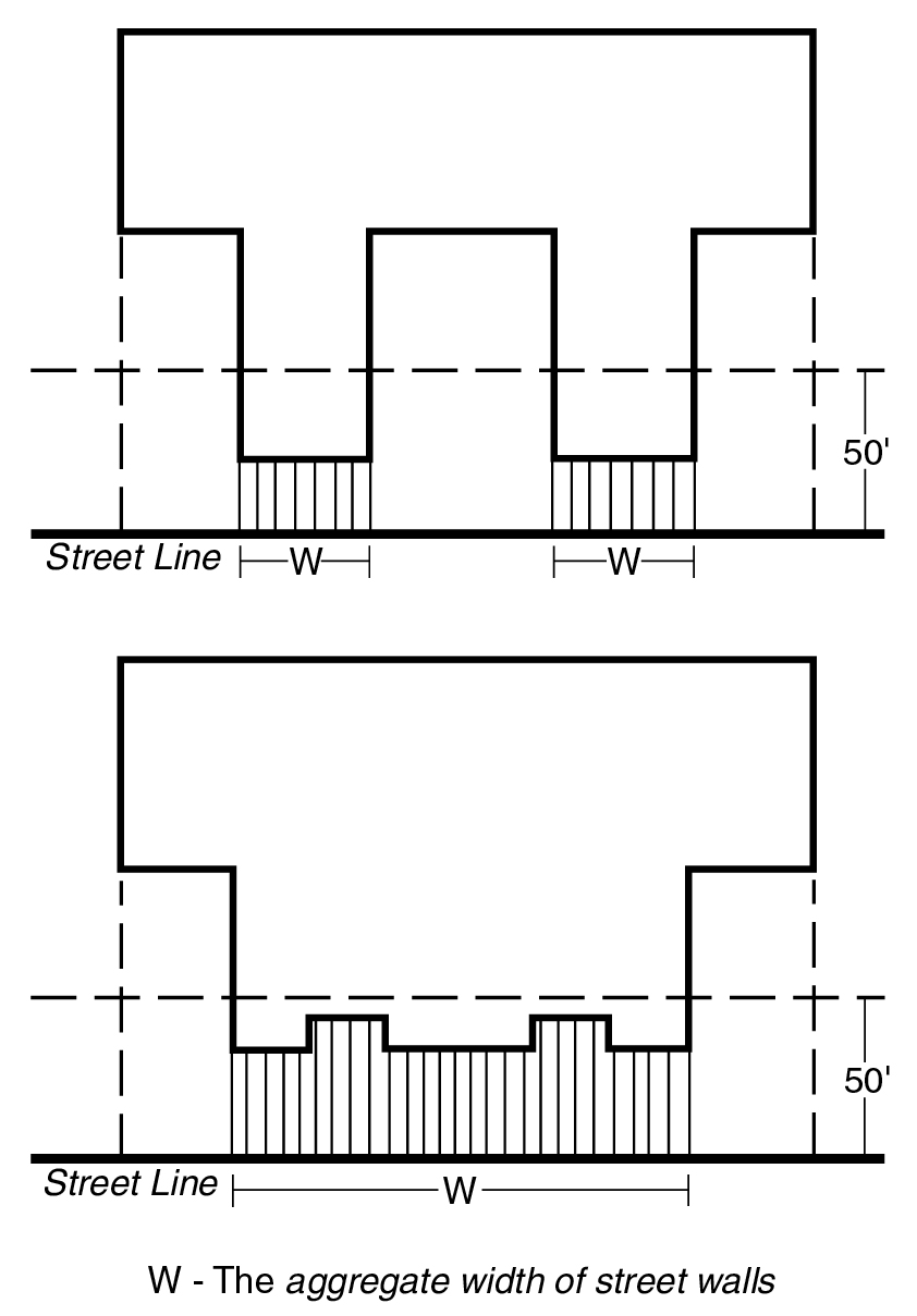
aggregate width of street walls
The "aggregate width of street walls" at any given level is the sum of the maximum widths of all street walls of a building that are within 50 feet of a street line. The width of a street wall is the length of the street line from which, when viewed directly from above, lines perpendicular to the street line may be drawn to such street wall.
AGGREGATE WIDTH OF STREET WALLS
airport reference point (or points)
The "airport reference point" (or "points") is a point (or points) within the boundaries of each major airport, as indicated on the flight obstruction area maps for each such major airport. The point or points applicable to each major airport are set forth in Section 61-41 (Airport Reference Point, Established Elevation and Specified Radii).
airport referenced imaginary surfaces
FROM 61-30: "Airport referenced imaginary surfaces" include the horizontal surface, the conical surface, the approach surfaces and the transitional surfaces.
alterations, incidental or to alter incidentally
"Incidental alterations" are:
(a) Changes or replacements in the non-structural parts of a building or other structure, without limitation to the following examples:
(1) alteration of interior partitions to improve livability in a non-conforming residential building, provided that no additional dwelling units are created thereby;
(2) a minor addition on the exterior of a residential building, such as an open porch;
(3) alteration of interior non-load-bearing partitions in all other types of buildings or other structures;
(4) replacement of, or minor changes in, the capacity of utility pipes, ducts or conduits; or
(b) Changes or replacements in the structural parts of a building or other structure, limited to the following examples or others of similar character or extent:
(1) making windows or doors in exterior walls;
(2) replacement of building facades;
(3) strengthening the load-bearing capacity, in not more than 10 percent of the total floor area, to permit the accommodation of a specialized unit of machinery or equipment. To "alter incidentally" is to make an incidental alteration.
apartment hotel
see hotel, apartment
approach surfaces
The "approach surfaces" are imaginary inclined planes, trapezoidal in shape and located symmetrically with respect to the extended center line of any runway. Such approach surfaces, extending from both ends of any runway, consist of contiguous inner and outer sections whose dimensions are as follows:
(a) The plane of the inner section:
(1) begins at a line drawn parallel to, and at the same elevation as, the end of the runway, and at a distance, measured horizontally along the extended runway centerline, of 200 feet from the end of the runway;
(2) extends for a distance of 10,000 feet, measured horizontally along the extended runway centerline;
(3) has a width of 1,000 feet measured along the line described in paragraph (a)(1) of this Section, which increases uniformly (with respect to the extended runway centerline) to a width of 4,000 feet at the outer edge of such inner section, as described in paragraph (a)(2) of this Section; and
(4) rises at a slope of one foot in height for every 50 feet of horizontal distance.
(b) The plane of the outer section:
(1) begins at the outer edge of the inner section;
(2) extends for a distance of 15,000 feet, measured horizontally along the extended runway centerline;
(3) has a width of 4,000 feet commencing at the outer edge of the inner section, which increases uniformly (with respect to the extended runway center line) to a width of 8,500 feet at the outer edge of such outer section; and
(4) rises at a slope of one foot in height for every 40 feet of horizontal distance.
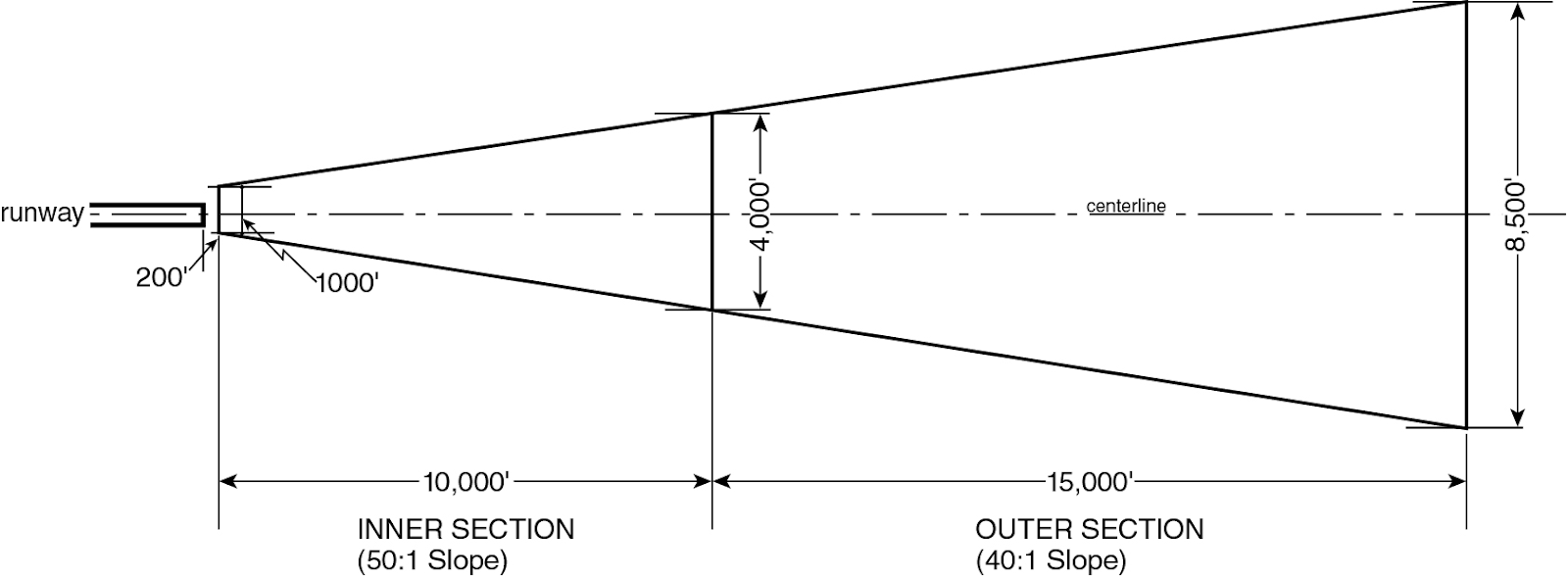
DESCRIPTION OF APPROACH SURFACE
arcade
An "arcade" is a continuous covered space fronting on and open to a street or publicly accessible open area, provided in accordance with the provisions set forth in Section 37-80.
area of no disturbance
FROM 105-01:
area of no disturbance
An "area of no disturbance" is an area designated on the site plan that is protected from all types of intrusion, including: site alteration, operation of construction equipment, storage of construction materials, excavation or regrading, tunneling for utilities, removal of trees, topsoil or any living vegetation, or construction of driveways, private roads, parking areas, patios, decks, swimming pools, walkways or other impervious surfaces. Areas of no disturbance shall include steep slopes, steep slope buffers and the critical root zone of each tree proposed for preservation.
area of no disturbance
FROM 119-01:
area of no disturbance
An "area of no disturbance" is an area designated on the site plan that is protected from all types of intrusion, including: site alteration, operation of construction equipment, storage of construction materials, excavation or regrading, tunneling for utilities, removal of trees, topsoil or any living vegetation, or construction of driveways, private roads, parking areas, patios, decks, swimming pools, walkways or other impervious surfaces. Areas of no disturbance shall include steep slopes, steep slope buffers and the critical root zone of each tree proposed for preservation.
area of no disturbance
FROM 107-01:
area of no disturbance
An “area of no disturbance” is an area designated on a site plan or area plan to be protected from site alteration, except for new native planting. An area of no disturbance shall contain natural features including trees of six-inch caliper or more, designated open space, and aquatic features.
Plan review sites may include safeguards such as an area of no disturbance to define areas where site alterations shall not be proposed.
area of no land alteration
From Section 107-01:
An “area of no land alteration” is an area adjacent to a wetland or other body of water regulated by the New York State Department of Environmental Conservation (NYSDEC) where a permit indicates development restrictions may occur such as those pursuant to permits or deed restrictions issued by NYSDEC.
area plan
FROM 107-01:
area plan
An “area plan” is a proposed layout for a zoning lot subdivision with traffic circulation, including curb cuts on arterials; access easements; areas of no disturbance; areas of no land alteration; areas of designated open space; building envelopes; required building setbacks within proposed zoning lots in Residence Districts; and any other information prescribed by the City Planning Commission.
arterial
artist
An "artist" is a person so certified by the New York City Department of Cultural Affairs.
at or below-grade mass transit station
FROM 66-11: For the purposes of this Chapter, an “at- or below-grade mass transit station” shall refer to a mass transit station that is not an above-grade mass transit stations.
attached (building)
A building shall be considered “attached” when it abuts two lot lines other than a street line, or another building or buildings other than a semi-detached building.
automated parking facility
An “automated parking facility” shall refer to an accessory off-street parking facility or public parking garage where vehicular storage and retrieval within such facility is accomplished entirely through a mechanical conveyance system. A parking facility with parking lift systems that require an attendant to maneuver a vehicle that is to be parked shall not be considered an automated parking facility.
automotive service station
An "automotive service station" is a building or other structure or an open use on a zoning lot, or portion thereof, used exclusively for the storage and sale of fuels for motor vehicles, and for any uses accessory thereto.
The sale of lubricants, accessories, or supplies, the lubrication of motor vehicles, the minor adjustment or repair of motor vehicles with hand tools only, or the occasional washing of motor vehicles, or electric vehicle charging, are permitted accessory uses.
A public parking lot or public parking garage is not a permitted accessory use.
average percent of slope
FROM 105-01:
average percent of slope
The "average percent of slope" of a zoning lot is the average slope of all portions of a zoning lot excluding steep slopes and shall be determined according to the following equation:
|
S |
= |
IL |
x |
100 |
|
A |
Where: S - average percent of slope
I - contour interval in feet
L - combined length of contour lines in feet, excluding those portions bordering or lying within areas having a slope of 25 percent or greater and meeting the definition of steep slope
A - gross area in square feet of the zoning lot, excluding those portions of the zoning lot having a slope of 25 percent or greater and meeting the definition of steep slope. For a proposed site alteration on a tract of land not within a zoning lot, the portion of such tract of land owned by the applicant shall be considered to be part of the zoning lot
100 - factor which yields slope as a percentage
CALCULATING AREAS HAVING A SLOPE EQUAL TO OR GREATER THAN 25 PERCENT (illustrative example)
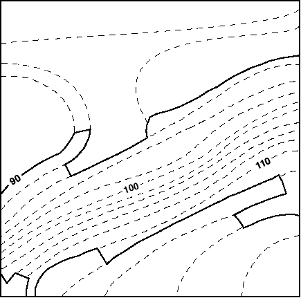
Example:
|
X |
= |
Contour interval in feet |
= |
2 |
= |
8.0 feet |
|
0.25 |
0.25 |
Where: X - distance between contour lines which indicates a slope of 25 percent
In order to calculate the area having a slope equal to or greater than 25 percent, one can use a map with two-foot contour intervals and a scale of one inch equals 20 feet, as shown in the map in this Section. A 25 percent slope, on a map with two-foot contour intervals, is indicated by contour lines that are 8.0 feet apart, rounded to the nearest tenth (0.1) of a foot. On a map whose scale is one inch to 20 feet, 8.0 feet is represented by 0.4 of an inch, rounded to the nearest tenth (0.1) of an inch.
Identify where the contour lines are 0.4 of an inch or less apart. Connect these contour lines (as indicated by the heavy lines on the map) and calculate the area.
average percent of slope
FROM 119-01:
average percent of slope
The "average percent of slope" of a zoning lot is the average slope of all portions of a zoning lot excluding steep slopes and shall be determined according to the following equation:
|
S |
= |
IL |
x |
100 |
|
A |
Where: S - average percent of slope
I - contour interval in feet
L - combined length of contour lines in feet, excluding those portions bordering or lying within areas having a slope of 25 percent or greater and meeting the definition of steep slope
A - gross area in square feet of the zoning lot, excluding those portions of the zoning lot having a slope of 25 percent or greater and meeting the definition of steep slope. For a proposed site alteration on a tract of land not within a zoning lot, the portion of such tract of land owned by the applicant shall be considered to be part of the zoning lot
100 - factor which yields slope as a percentage
CALCULATING AREAS HAVING A SLOPE EQUAL TO OR GREATER THAN 25 PERCENT (illustrative example)
Example:
|
X |
= |
Contour interval in feet |
= |
2 |
= |
8.0 feet |
|
0.25 |
0.25 |
Where: X - distance between contour lines which indicates a slope of 25 percent
In order to calculate the area having a slope equal to or greater than 25 percent, one can use a map with two-foot contour intervals and a scale of one inch equals 20 feet, as shown in the map in this Section. A 25 percent slope, on a map with two-foot contour intervals, is indicated by contour lines that are 8.0 feet apart, rounded to the nearest tenth (0.1) of a foot. On a map whose scale is one inch to 20 feet, 8.0 feet is represented by 0.4 of an inch, rounded to the nearest tenth (0.1) of an inch.
Identify where the contour lines are 0.4 of an inch or less apart. Connect these contour lines (as indicated by the heavy lines on the map) and calculate the area.
Barge Basin
From Section 144-01:
Barge Basin shall mean that inlet from the East River identified on Map 2 in the Appendix to this Chapter as the Barge Basin.
base plane
The "base plane" is a plane from which the height of a building or other structure is measured as specified in certain Sections. For buildings, portions of buildings with street walls at least 15 feet in width, or building segments within 100 feet of a street line, the level of the base plane is any level between curb level and street wall line level. Beyond 100 feet of a street line, the level of the base plane is the average elevation of the final grade adjoining the building or building segment, determined in the manner prescribed by the New York City Building Code for adjoining grade elevation. For the purposes of this definition, abutting buildings on a single zoning lot may be considered a single building. In addition, the following regulations shall apply:
(a) Within 100 feet of a street line:
(1) The level of the base plane for a building or building segment without a street wall shall be determined by the average elevation of the final grade adjoining such building or building segment.
(2) Where a base plane other than curb level is established, the average elevation of the final grade adjoining the street wall of the building or building segment, excluding the entrance to a garage within the street wall, shall not be lower than the level of the base plane.
(3) Where the average elevation of the final grade adjoining the street wall of the building, excluding the entrance to a garage within the street wall, is more than two feet below curb level, the level of the base plane shall be the elevation of such final grade. This paragraph shall not apply to buildings developed before June 30, 1989, in R2X, R3, R4 or R5 Districts. Furthermore, this paragraph shall not apply to buildings in C1 or C2 Districts mapped within R2X, R3, R4 or R5 Districts, or in C3 or C4-1 Districts, unless such buildings are located on waterfront blocks.
(4) As an option, on sites which slope from the street wall line level to the rear wall line level by at least five percent to the horizontal, the level of the base plane may extend in a sloping plane from such street wall line level to such rear wall line level. When a sloping base plane is thus established, the average elevation of the final grade at the rear wall line shall not be lower than the rear wall line level.
(b) For all buildings, where base planes of different elevations apply to different portions of a building, only that portion of the building to which such base plane applies may be used to determine such base plane.
(c) For buildings located partially within and partially beyond 100 feet of a street line, or where corner lot or through lot regulations subject different portions of a building to base planes of different elevations, separate base planes may be determined for each such portion of the building or, as an option, the elevation of each such base plane may be multiplied by the percentage of the total lot coverage of the building to which such base plane applies. The sum of the products thus obtained may be the elevation of the adjusted base plane applicable to such building.
basement
A "basement", except where a base plane is used to determine building height, is a story (or portion of a story) partly below curb level, with at least one-half of its height (measured from floor to ceiling) above curb level. On through lots, the curb level nearest to a story (or portion of a story) shall be used to determine whether such story (or portion of a story) is a basement.
Where a base plane is used to determine building height, a basement is a story (or portion of a story) partly below the base plane, with at least one-half its height (measured from floor to ceiling) above the base plane.
In addition, the following rules shall apply:
(a) When a sloping base plane is established, a basement is a story (or portion of a story) partly below the street wall line level, with at least one-half its height (measured from floor to ceiling) above the street wall line level used to establish such base plane. On through lots, the street wall line level nearest to a story shall be used to determine whether such story or portion of a story is a basement.
(b) All of the floor space with at least one-half its height (measured from floor to ceiling) above curb level shall be considered to be a basement where, subsequent to December 5, 1990, the level of any yard except that portion of a yard in front of the entrance to a garage on a zoning lot is lowered below the level of the base plane.
block
A "block" is a tract of land bounded by:
(a) streets;
(b) public parks;
(c) railroad rights-of-way, when located at or above ground level but not including sidings or spurs in the same ownership as the zoning lot;
(d) airport boundaries;
(e) pierhead lines (or shore lines where no pierhead lines have been established); or
(f) corporate boundary lines of New York City.
boatel
A "boatel" is a building or group of buildings which:
(a) contains living or sleeping accommodations used primarily for transient occupancy; and
(b) is immediately accessible by boat.
buildable area
building
A "building" is any structure which:
(a) is located within the lot lines of a zoning lot;
(b) is permanently affixed to the land;
(c) has one or more floors and a roof;
(d) is bounded by open area or fire walls;
(e) has at least one primary entrance;
(f) provides all the vertical circulation and exit systems required for such building by the New York City Building Code without reliance on other buildings, including required stairs and elevators; and
(g) contains all the fire protection systems required for such building by the New York City Building Code without reliance on other buildings, including fire suppression or fire alarm systems.
The provisions of this Resolution that use the term building shall apply to any structure existing prior to February 2, 2011, that complies with paragraphs (a) through (e) of this definition.
A building shall not include such structures as billboards, fences, or radio towers, or structures with interior surfaces not normally accessible for human use, such as gas tanks, smoke stacks or similar structures.
A building may, for example, consist of a detached single-family residence, an attached townhouse on an individual zoning lot, an attached townhouse separated by fire walls from abutting townhouses on a shared zoning lot, a group of townhouses not separated by fire walls or lot lines, an apartment house, an office building or a factory.
building designed for residential use
see designed for residential use
building or other structure
A "building or other structure" includes any building or any other structure of any kind.
building segment
A "building segment" is a portion of a building where such building consists of two or more contiguous portions, each comprised of one or more dwelling units having a separate residential entrance or entrances serving only those dwelling units within such portion. Building segments may share a common cellar or parking facility. However, a building segment may not be located above another building segment.
bulk
"Bulk" is the term used to describe the size of buildings or other structures, and their relationships to each other and to open areas and lot lines, and therefore includes:
(a) the size (including height and floor area) of buildings or other structures;
(b) the area of the zoning lot upon which a building is located, and the number of dwelling units or rooming units within a building in relation to the area of the zoning lot;
(c) the shape of buildings or other structures;
(d) the location of exterior walls of buildings or other structures in relation to lot lines, to other walls of the same building, to legally required windows, or to other buildings or other structures; and
(e) all open areas relating to buildings or other structures and their relationship thereto.
caliper (of a tree)
FROM 105-01:
caliper (of a tree)
"Caliper" of a tree is the diameter of a tree trunk measured 4 feet, 6 inches from the ground. If a tree splits into multiple trunks below 4 feet, 6 inches from the ground, the trunk is measured at its most narrow point beneath the split.
caliper (of a tree)
FROM 119-01:
caliper (of a tree)
"Caliper" of a tree is the diameter of a tree trunk measured 4 feet, 6 inches from the ground. If a tree splits into multiple trunks below 4 feet, 6 inches from the ground, the trunk is measured at its most narrow point beneath the split.
caliper (of a tree)
FROM 107-01:
“Caliper” of a tree is the diameter of a tree trunk measured 4 feet, 6 inches from the ground. If a tree splits into multiple trunks below this height, the trunk is measured at its narrowest point beneath the split. For trees with a diameter of less than three inches measured 4 feet, 6 inches from the ground, the caliper shall be measured 12 inches from the ground.
car sharing vehicle
A “car sharing vehicle” is a vehicle maintained and owned or leased by a car sharing organization which is available for use by its members. Membership shall mean that individuals have been pre-approved to use such vehicles and need not be approved by the car sharing organization at the time of proposed use. Membership must be open to the public and shall only be denied based upon driving record, credit record or other legitimate business need of the car sharing organization. Vehicles must be made available to members for periods of use as short as one hour. The car sharing organization must provide all legally required insurance as part of the membership.
Vehicles shall be reserved by members through a self-service reservation system which is available at all times. A car sharing vehicle shall be located in a parking facility that is accessible to members of the car sharing organization at all times. No employees or agents of the car sharing organization shall provide services to members or conduct business transactions with members within such parking facility. Attended parking facilities may be serviced by a parking attendant unaffiliated with any car sharing organization. A parking facility containing car sharing vehicles shall be securely separated from all other portions of a building containing residences.
A car sharing vehicle shall be no more than 216 inches in length and shall bear a decal that provides the name of the car sharing organization. The decal must be clearly visible from the outside of the car sharing vehicle and must be either:
(a) located on the driver’s side door or passenger’s side door of the car sharing vehicle and at least 30 square inches in area; or
(b) located in the lower left corner of the rear windshield of the car sharing vehicle.
The decal shall be at least one square inch in area and contain the letters “CSV” in lettering at least 11/32 of an inch in height and the name of the car sharing organization in lettering at least 5/32 of an inch in height. All lettering shall be fully opaque and shall highly contrast with the background color of the decal.
All car sharing vehicles shall bear a decal pursuant to the provisions of paragraph (a) or (b) of this Section within 60 days of September 29, 2010.
cellar
A "cellar," except where a base plane is used to determine building height, is a space wholly or partly below curb level, with more than one-half its height (measured from floor to ceiling) below curb level. On through lots, the curb level nearest to such space shall be used to determine whether such space is a cellar.
Where a base plane is used to determine building height, a cellar is a space wholly or partly below the base plane, with more than one-half its height (measured from floor to ceiling) below the base plane.
In addition, the following rules shall apply:
(a) When a sloping base plane is established, a cellar is a space wholly or partly below the street wall line level, with more than one-half its height (measured from floor to ceiling) below the street wall line level used to establish such base plane. On through lots, the street wall line level nearest to such space shall be used to determine whether such space is a cellar.
(b) All of the floor space with at least one-half its height (measured from floor to ceiling) above curb level shall be considered to be a basement where, subsequent to December 5, 1990, the level of any yard except that portion of a yard in front of the entrance to a garage on a zoning lot is lowered below the level of the base plane.
center line of the street (bounding a #zoning lot#)
A line equidistant from and parallel or nearly parallel to the street lines on both sides of the street. However, for the purposes of daylight evaluation:
- on a street 75 feet in width, the center line of the street shall be considered to be a line 40 feet from, and parallel to, the front lot line of the zoning lot; and
- on a street more than 100 feet in width, the center line of the street shall be considered to be a line 50 feet from, and parallel to, the front lot line of the zoning lot.
Central Business Districts
For the purposes of this Chapter, “Central Business Districts” shall refer to Special Midtown District, Special Hudson Yards District, Special Lower Manhattan District, Special Downtown Brooklyn District, Special Long Island City Mixed Use District or Special Garment Center District.
clear path
FROM 66-11: For the purposes of this Chapter, a “clear path” shall refer to an unobstructed area between the street line and street wall that:
(a) directly abuts an adjoining public sidewalk; and
(b) extends along the street line for a distance equal to the width of an existing or planned access point to a mass transit station facing such transit-adjacent site, plus, in the aggregate, a maximum of 30 feet from the outermost extents of such width.
All clear paths shall be accessible to the public at all times.
commercial
A "commercial” use is any use listed in Use Groups 5, 6, 7, 8, 9, 10, 11, 12, 13, 14, 15 or 16.
commercial building
A "commercial building" is a building used only for a commercial use.
commercial district
A "Commercial District" includes any district whose designation begins with the letter "C."
For example, a "C4 District" includes any district whose designation begins with the symbol "C4."
commercial street
FROM 128-01:
commercial street
A “commercial street” shall be a street, or portion thereof, where special regulations pertaining to ground floor uses on commercial streets, pursuant to Section 128-11, apply to zoning lots fronting upon such streets. Commercial streets are designated on Map 2 in the Appendix to this Chapter.
community facility
A "community facility” use is any use listed in Use Group 3 or 4.
community facility building
A "community facility building" is a building used only for a community facility use.
Compensating recess
A portion of a zoning lot which, at the building height selected for determining compliance with the provisions of Section 81-26 (Height and Setback Regulations--Daylight Compensation), lies in the free zone (Zone A on the encroachment grid), is not covered by any portion of a building and qualifies as compensating for encroachments beyond the free zone under the provisions of Section 81-264 (Encroachments and compensating recesses). (See illustration of Compensating Recess and Encroachment).
[COMPENSATING RECESS AND ENCROACHMENT image]
completely enclosed (building)
A "completely enclosed" building is a building separated on all sides from the adjacent open area, or from other buildings or other structures, by a permanent roof and by exterior walls or party walls, pierced only by windows or entrances or exit doors normally provided for the accommodation of persons, goods or vehicles.
conceptual plan
FROM 127-04:
conceptual plan
A “conceptual plan” is a plan that sets forth the proposed final design, in compliance with the requirements of Section 127-421 (Requirements for publicly accessible private streets), for the remaining portions of the publicly accessible private street or upland connection certified pursuant to paragraph (b)(1)(i) of Section 127-422 (Certification for publicly accessible private streets), or paragraph (a)(1)(i) of Section 127-542 (Supplemental provisions), respectively. The plan shall include the proposed location, dimensions and grading for such remaining portions on adjoining zoning lots and shall be considered by the Chairperson of the City Planning Commission in reviewing the proposed final site plan for such remaining portions, if and when they become the subject of a certification pursuant to paragraph (b)(2) of Section 127-422 or paragraph (a)(2) of Section 127-542.
conical surface
The "conical surface" is an imaginary inclined surface extending upward and outward from the periphery of the horizontal surface, which:
(a) rises at a slope, measured in an imaginary vertical plane passing through the airport reference point (or points), of one foot for every 20 feet in horizontal distance; and
(b) is measured on a horizontal radius from the airport reference point (or points), and extends for a distance set forth in Section 61-41 (Airport Reference Point, Established Elevation and Specified Radii).
conversion, or to convert
A “conversion” is a change of use between the following categories of uses: residential, community facility, commercial and manufacturing. Therefore, the change of use within one category is not a conversion. However, a conversion shall also include any alteration within the residential portion of an existing building that increases the number of rooming units in a building, or the number of dwelling units in a building.
To "convert" is to create a conversion.
corner lot
see lot, corner
corner public plaza
A “corner public plaza” is a public plaza that is located on an intersection of two or more streets.
cottage envelope building
A “cottage envelope building” is a single- or two-family detached residence located within R1 through R5 Districts, developed, enlarged, or altered, pursuant to any of the optional provisions of Section 64-33 (Special Regulations for Cottage Envelope Buildings), provided that:
(a) such single- or two-family detached residence[a]# complies with Section 64-333 (Height and setback regulations for cottage envelope buildings); and
(b) is located within a zoning lot that has a lot area that is less than that required by the applicable district; and
(1) has a lot width that is either:
(i) less than that required under the provisions of Section 23-32 (Minimum Lot Area or Lot Width for Residences) in R1, R2, R3-1, R3-2, R3X, R4, R4A, R5, and R5A Districts; or
(ii) equal to or less than 30 feet in R3A, R4-1, R4B, R5B, and R5D Districts; or
(2) has a depth of less than 95 feet at any point.
All cottage envelope buildings shall also be flood-resistant buildings.
court
A "court" is either an inner court or an outer court.
court recess, inner
An "inner court recess" is any portion of an inner court which can not be included within the single largest horizontal rectangle which may be inscribed within such inner court.
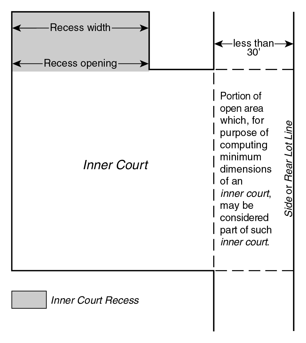
INNER COURT RECESS
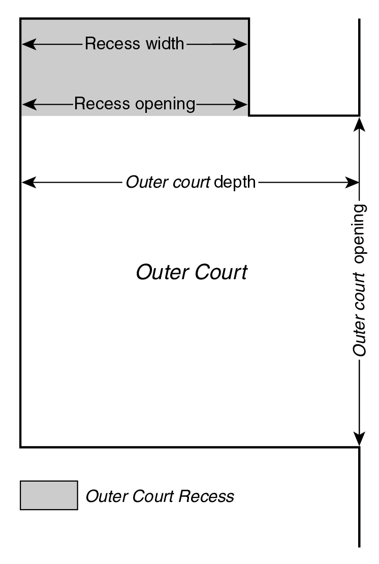
court recess, outer
An "outer court recess" is any portion of an outer court which, when viewed directly from above, cannot be covered by imaginary lines drawn perpendicular to a line drawn across the outer court opening.
OUTER COURT RECESS
court, depth of outer
The "depth of outer court" is the maximum horizontal distance between the opening of an outer court and the wall opposite such opening, measured perpendicular to the direction of the outer court opening. The opening of an outer court shall be considered the shortest imaginary line which can be drawn between any intersection of a court wall with another wall, and the opposite court wall.
court, inner
An "inner court" is any open area, other than a yard or portion thereof, which is unobstructed from its lowest level to the sky and which is bounded by either:
(a) building walls; or
(b) building walls and one or more lot lines other than a front lot line; or
(c) building walls, except for one opening on any open area along a side lot line or rear lot line which has a width of less than 30 feet at any point.
court, outer
An "outer court" is any open area, other than a yard or portion thereof, which is unobstructed from its lowest level to the sky and which, except for one opening upon:
(a) a front lot line;
(b) a front yard;
(c) a rear yard; or
(d) any open area along a rear lot line, or along a side lot line having a width or depth of at least 30 feet, and which open area extends along the entire length of such rear or side lot line; and
is bounded by either building walls, or building walls and one or more lot lines other than a front lot line.
court, width of outer
The "width of outer court" is the minimum horizontal dimension of an outer court, excluding an outer court recess, measured parallel to the opening of such outer court.
Cove
FROM 116-01:
Pier Place, the Cove
"Pier Place" and the "Cove" are designated open spaces accessible to the public, located within the Special Stapleton Waterfront District as shown in the District Plan, Map 1, in Appendix A of this Chapter
covered pedestrian space
A "covered pedestrian space" is an enclosed space for public use on a zoning lot, permitted by a special permit of the City Planning Commission pursuant to Section 74-87, et seq.
critical root zone
FROM 105-01:
critical root zone
The "critical root zone" of a tree is the area containing the roots of a tree that must be maintained and protected to ensure the tree's survival. The area of the critical root zone is measured as one radial foot for every caliper inch of the tree, with a required minimum of four radial feet and maximum of 22 radial feet, measured from the surface of the tree trunk at grade.
critical root zone
FROM 119-01:
critical root zone
The "critical root zone" of a tree is the area containing the roots of a tree that must be maintained and protected to ensure the tree's survival. The area of the critical root zone is measured as one radial foot for every caliper inch of the tree, with a required minimum of four radial feet and maximum of 22 radial feet, measured from the surface of the tree trunk at grade.
curb level
"Curb level" is the mean level of the curb adjoining a zoning lot. On corner lots, curb level is the average of the mean levels of the adjoining curbs on intersecting streets, except that, for the purpose of regulating and determining the level of yards, or other open areas on corner lots, the curb level is the highest of the mean levels of the curbs on the intersecting streets. Where through lot regulations are applicable to any portion of a corner lot, or for any through lot, the height and setback regulations based upon curb level shall apply separately on each street on which such through lot portion or through lot fronts. On a through lot, for purposes of establishing the level of a rear yard equivalent, except when adjoining and extending along the full length of the street line, the curb level shall be the mean of the levels of the curbs on those portions of the streets on which such through lot fronts. Where on a through lot such rear yard equivalent is adjoining and extending along the full length of the street line, the height of the rear yard equivalent shall be the curb level of the adjoining street. Where through lot regulations and interior lot regulations are applicable to portions of a zoning lot, for purposes of establishing the level of the rear yard equivalent or rear yard, curb level shall be the mean of the levels of the curbs on that portion of each street on which such portions of the zoning lot front.
For the purposes of determining a base plane, "curb level" is the mean level at that portion of the curb adjoining a zoning lot from which, when viewed directly from above, lines perpendicular to the curb may be drawn to a street wall. On corner lots, curb level is the average of the mean levels of such portions of the curbs on intersecting streets. On through lots, curb level is determined separately for each street frontage to a distance midway between such streets.
Daylight Evaluation Chart (DEC)
A graphic tool which permits objective measurements of portions of sky blocked by a building when it is viewed from a vantage point. There are three daylight evaluation charts for use with street widths of 60 feet, 75 to 80 feet and 100 feet and over, respectively. All buildings are drawn on the appropriate daylight evaluation chart to evaluate their compliance with the regulations of Section 81-27 (Alternate Height and Setback Regulations—Daylight Evaluation). These three daylight evaluation charts are in Appendix B of this Chapter. A fourth chart in Appendix B is available for use with qualifying sites in the East Midtown Subdistrict, as defined in Section 81-613, with frontage along Park Avenue.
depth of outer court
see court, depth of outer
designated open space
FROM 107-01:
designated open space
"Designated open space" is a portion of the open space network located on a zoning lot as shown on the District Plan (Map 3 in Appendix A), and is to be preserved in its natural state in accordance with the provisions of the Special South Richmond Development District.
designated recovery area
A “designated recovery area” shall be an area which experienced physical or non-physical impacts from a severe disaster, in accordance with recovery plans, as applicable.
designed for residential use, (building)
A building "designed for residential use" is a building, which was originally designed for residential use and in which at least 25 percent of the floor area is occupied for residential use.
detached (building)
A "detached" building is a building surrounded by yards or other open area on the same zoning lot.
detached (building)
FROM 107-01:
detached
For the purposes of this Chapter a "detached" building is a building surrounded by yards or other open area on the same zoning lot or is a building abutting a street line which is surrounded by yards or open area on the same zoning lot except where the building abuts the street line.
development
For purposes of this Chapter, a "development" includes both development and enlargement, as defined in Section 12-10 (DEFINITIONS).
development, or to develop
A "development,” on a zoning lot or a portion thereof, includes:
(a) the construction of a new building or other structure;
(b) the relocation of an existing building or other structure to another zoning lot; or
(c) the establishment of a new open use, other than an accessory use.
The alteration of a building or a portion thereof to the extent specified in Section 11-23 (Demolition and Replacement) shall be considered a development for the purposes of the provisions set forth therein.
To "develop" is to create a development.
development, or to develop
FROM 62-11:
For the purposes of this Chapter, a “development” shall also include:
(a) an enlargement;
(b) any alteration that increases the height or coverage of an existing building or other structure;
(c) an extension; or
(d) a change of use from one Use Group to another, or from one use to another in the same Use Group, or from one use listed in Section 62-21 (Classification of Uses in the Waterfront Area) to another such use.
However, a development shall not include incidental modifications to a zoning lot, including but not limited to, the addition of deployable flood control measures and any associated permanent fixtures, the addition of temporary structures such as trash receptacles, food carts or kiosks, and the incorporation of minor permanent structures such as light stanchions, bollards, fences, or structural landscaped berms and any associated flood gates. All such modifications shall remain subject to any associated permitted obstruction allowances, as applicable.
development, or to develop
For purposes of this Chapter, "development" includes a development, an enlargement or an extension.
development, or to develop
FROM 107-01:
Development
For the purposes of this Chapter, a "development" includes a development as defined in Section 12-10 (DEFINITIONS), the enlargement of a non-residential building, or the enlargement of a residential use that involves the addition of one or more dwelling units.
To "develop" is to create a development.
display window
FROM 122-01:
Display window
A "display window" is a window or opening in the exterior wall of any portion of a building which is glazed with tinted or transparent material and which is used to display merchandise, services or business.
dwelling unit
A "dwelling unit" contains at least one room in a residential building, residential portion of a building, or non-profit hospital staff dwelling, and is arranged, designed, used or intended for use by one or more persons living together and maintaining a common household, and which dwelling unit includes lawful cooking space and lawful sanitary facilities reserved for the occupants thereof.
easement volume
FROM 66-11: For the purposes of this Chapter, an “easement volume” shall refer to an area of the zoning lot used to accommodate either:
(a) station access infrastructure, including but not limited to elevators, stairs, escalators, ramps or fare control areas; or
(b) ancillary facilities that are needed to support transit system functionality.
eligible zoning districts
FROM 66-11: For the purposes of this Chapter, “eligible zoning districts” shall refer to the following zoning districts:
(a) R5D, R6, R7, R8, R9 or R10 Districts;
(b) Commercial Districts mapped within, or with an equivalent of an R5, R5D, R6, R7, R8, R9, or R10 District;
(c) M1 Districts paired with R6 through R10 Districts; or
encroachment
A projection beyond the setback line, the free zone or the half-setback line by any portion of a building that exceeds the maximum height permitted at the street line. (See illustration of Compensating Recess and Encroachment)
encroachment grid
A plan drawing of the zoning lot at any given height above curb level selected to determine compliance with the provisions of Section 81-26 and showing, for that height, street lines, setback lines, half-setback lines, Zone A (the free zone), Zone B and Zone C (encroachment zones) and, where applicable, the ten-foot setback line. The encroachment grid serves as a device for measuring areas of encroachment beyond the free zone and areas of compensating recess within the free zone. (See illustration of Encroachment Grid)
[ENCROACHMENT GRID image]
energy infrastructure equipment
“Energy infrastructure equipment” shall include renewable energy generation systems, such as solar or wind energy systems, and energy storage systems, such as fuel cells and batteries, which are essential throughout all districts in order to support the acceleration towards a distributed energy grid with electricity from fully renewable sources.
Energy infrastructure equipment shall refer to equipment that is a principal use on a zoning lot. Where such equipment is accessory to another use, it shall be considered accessory mechanical equipment.
Provisions pertaining to energy infrastructure equipment shall apply to all types of renewable energy generation systems, as well as to all types of energy storage systems, unless specific rules are otherwise specified, such as for solar and wind energy systems.
enlargement, or to enlarge
An "enlargement" is an addition to the floor area of an existing building, an increase in the size of any other structure, or an expansion of an existing use, including any uses accessory thereto, to an open portion of a zoning lot not previously used for such use.
To "enlarge" is to make an enlargement.
Esplanade
FROM 116-01:
Esplanade
The "Esplanade" is a park extending along portions of the waterfront edges of the Special Stapleton Waterfront District. The Esplanade is shown in the District Plan, Map 1 (Special Stapleton Waterfront District, Subareas and Public Spaces), in Appendix A of this Chapter.
Esplanade
FROM 84-01:
The "Esplanade" is a public park extending along all waterfront edges of the Special Battery Park City District. The Esplanade is shown in the District Plan in Appendix 1.
established airport elevation
The "established airport elevation" is the elevation above mean sea level of the highest point of the usable airport landing area for any major airport. The elevation applicable to each major airport is set forth in Section 61-41 (Airport Reference Point, Established Elevation and Specified Radii).
extension, or to extend
An "extension" is an increase in the amount of existing floor area used for an existing use, within an existing building.
To "extend" is to make an extension.
family
A "family" is either:
(a) a single person occupying a dwelling and maintaining a household, including not more than one "boarder, roomer, or lodger" as defined in the Housing Maintenance Code; or
(b) two or more persons related by blood or marriage, occupying a dwelling, living together and maintaining a common household, including not more than one such boarder, roomer, or lodger; or
(c) not more than four unrelated persons occupying a dwelling, living together and maintaining a common household.
A common household shall be deemed to exist if all members thereof have access to all parts of the dwelling.
far lot line
A lot line intersecting the street line of the vantage street such that, when viewed from the vantage point, the zoning lot does not contain any lot area that is on the far side of and immediately adjoining the lot line at its intersection with the street line. (See illustration of Far Lot Line and Vantage Point)
[FAR LOT LINE graphic]
final site plan
FROM 127-04:
final site plan
A “final site plan” is a plan that specifies the final design for the location, dimensions, and grading of all or portions of the publicly accessible private streets or upland connection that are the subject of a certification pursuant to paragraphs (a) or (b) of Section 127-422 or paragraphs (a)(1) or (a)(2) of Section 127-542. Where applicable, the design of such plan shall be consistent with any conceptual plan for the same portion of the publicly accessible private street or upland connection and, once certified and implemented in accordance with paragraph (b) of Section 127-422 or paragraph (a) of Section 127-542, such plan shall supersede any interim plan for the same portion of a publicly accessible private street or upland connection.
fire wall
(a) A “fire wall” is a fire-resistance-rated smoke-tight wall having protected openings which restricts the spread of fire and extends vertically without offset, continuously from the foundation to or through the roof, and is in accordance with the specifications of the New York City Building Code for fire walls or fire wall separations, as applicable.
(b) Where a wall constructed prior to February 2, 2011, does not meet the requirements of paragraph (a), but does meet the fire wall specifications of the New York City Building Code pursuant to which it was constructed, such wall shall be considered a fire wall. In the event that such wall either fails to meet such specifications, or no specifications for fire walls existed at the time of its construction, the Commissioner of the Department of Buildings shall determine whether such wall shall be considered a fire wall for the purpose of determining the boundary of a building.
first story above the flood elevation
The “first story above the flood elevation” shall be the finished floor level of the first story located at or above the level at which a building complies with flood-resistant construction standards and, for buildings utilizing the reference plane, shall be no lower than the particular level established as the reference plane.
flashing sign
see sign, flashing
flight obstruction area
The "flight obstruction area" comprises all areas of land or water below the airport referenced imaginary surfaces for each airport.
floating structure
A “floating structure” is any vessel, barge or other water-supported structure, other than a floating dock accessory to a WD use, which is bounded by either open water, a dock or the lot lines of a zoning lot, and that is permanently moored or otherwise attached to a pier, wharf, dock, platform, bulkhead or flotation system for a period of more than 180 consecutive days. Support by means of a cradle or as a result of natural siltation shall not exempt a normally water-supported structure from this definition.
Any water-supported structure, other than a navigational vessel, docked for not more than 180 consecutive days for a purpose other than navigation or accessory to a WD use, shall be deemed to be a "temporary floating structure." Such temporary floating structures shall only be permitted subject to the approval of the Commissioner of Buildings or Business Services, as applicable.
flood map
“Flood map” shall be the most recent map or map data used as the basis for flood-resistant construction standards.
flood zone
The “flood zone” shall include the high-risk flood zone and the moderate-risk flood zone, as defined in Section 64-11 (Definitions) and as indicated on the flood maps
flood-resistant building
A “flood-resistant building” is a building or other structure, which complies with all applicable flood-resistant construction standards
flood-resistant construction elevation
The “flood-resistant construction elevation” shall be the level of flood elevation required by Appendix G of the New York City Building Code for the “Flood design classification” of a building or other structure as set forth therein, or a height of two feet above the lowest grade adjacent to the building or other structure, whichever is higher.
flood-resistant construction standards
“Flood-resistant construction standards” are the construction standards set forth in Appendix G of the New York City Building Code for “Post-FIRM Construction” that aid in protecting buildings or other structures in flood zones from flood damage, and governs both building or other structures that are required to comply with such standards and those that voluntarily comply. For buildings or other structures utilizing the provisions of this Chapter, flood-resistant construction standards shall be applied up to the flood-resistant construction elevation or higher.
floor area
"Floor area" is the sum of the gross areas of the several floors of a building or buildings, measured from the exterior faces of exterior walls or from the center lines of walls separating two buildings. In particular, floor area includes:
(a) basement space, except as specifically excluded in this definition;
(b) elevator shafts or stairwells at each floor, except as specifically excluded in this definition;
(c) floor space in penthouses;
(d) attic space (whether or not a floor has been laid) providing structural headroom of five feet or more in R2A, R2X, R3, R4 or R5 Districts, eight feet or more in R1 and R2 Districts, other than R2A and R2X Districts, and eight feet or more for single- or two-family residences in R6, R7, R8, R9 and R10 Districts. For buildings with three or more dwelling units in R6, R7, R8, R9 and R10 Districts developed or enlarged prior to February 2, 2011, such attic space providing structural headroom of eight feet or more shall be considered floor area. For buildings with three or more dwelling units in R6, R7, R8, R9 and R10 Districts developed or enlarged after February 2, 2011, any attic space shall be considered floor area;
(e) floor space in gallerias, interior balconies, mezzanines or bridges;
(f) floor space in open or roofed bridges, breeze ways or porches, if more than 50 percent of the perimeter of such bridge, breeze way or porch is enclosed, and provided that a parapet not higher than 3 feet, 8 inches, or a railing not less than 50 percent open and not higher than 4 feet, 6 inches, shall not constitute an enclosure;
(g) any other floor space used for dwelling purposes, no matter where located within a building, when not specifically excluded;
(h) floor space in accessory buildings, except for floor space used for accessory off-street parking or accessory mechanical equipment;
(i) floor space used for accessory off-street parking spaces provided in any story after June 30, 1989:
(1) within detached or semi-detached single- or two-family residences in R1-2A, R2A, R2X, R3, R4 or R5 Districts, except that:
(i) in R2A Districts, floor area within such residences shall include only floor space in excess of 300 square feet for one such space; and
(ii) in all R1-2A Districts, and in R3, R4A and R4-1 Districts in lower density growth management areas, floor area within such residences shall include only floor space in excess of 300 square feet for one such space and in excess of 500 square feet for two such spaces;
(2) within buildings containing residences developed or enlarged pursuant to the optional regulations applicable in a predominantly built-up area;
(3) in excess of 100 square feet per required space in individual garages within other buildings containing residences (attached buildings, rowhouses or multiple dwellings) in R3-2, R4 or R5 Districts, except that in R3-2 Districts within lower density growth management areas, floor area shall only include floor space in excess of 300 square feet for one such space and in excess of 500 square feet for two such spaces. However, all of the floor space within any story in individual garages shall be considered floor area where, subsequent to June 7, 1989, the level of any yard except that portion of a yard in front of a garage on the zoning lot is lowered below the lower of:
(i) curb level; or
(ii) grade existing on June 7, 1989;
(4) within a group parking facility with five or more required spaces accessory to buildings containing residences in R3, R4 or R5 Districts that is located in a space with a ceiling height that is more than six feet above the base plane, or, if the base plane is a sloping base plane, six feet above the street wall line level used to establish such base plane. On through lots with sloping base planes, the street wall line level closest to a street shall be used to determine whether such space is floor area;
(5) which is located more than 23 feet above curb level in any other building;
(6) which is unenclosed and covered by a building or other structure containing residential use for at least 50 percent of such accessory off-street parking space in R2A, R2X, R3, R4 and R5 Districts. Where such accessory off-street parking space is covered by any portion of a building or other structure containing residential use, other than a single- or two-family detached or semi-detached residence in R3-2, R4 or R5 Districts, and not developed or enlarged pursuant to the optional regulations applicable in a predominantly built-up area, such floor area shall include only that portion of the accessory off-street parking space in excess of 100 square feet per required space;
(j) floor space used for accessory off-street loading berths in excess of 200 percent of the amount required by the applicable district regulations;
(k) floor space that is not otherwise exempt pursuant to this Section and is, or is made, inaccessible within a building;
(l) floor space in exterior balconies or in open or roofed terraces if more than 67 percent of the perimeter of such balcony or terrace is enclosed and provided that a parapet not higher than 3 feet, 8 inches, or a railing not less than 50 percent open and not higher than 4 feet, 6 inches, shall not constitute an enclosure. For the purposes of such calculation, exterior building walls on adjoining zoning lots abutting an open or roofed terrace shall not constitute an enclosure. A sun control device that is accessible for purposes other than for maintenance shall be considered a balcony; and
(m) any other floor space not specifically excluded.
However, the floor area of a building shall not include:
(1) cellar space, except where such space is used for dwelling purposes. Cellar space used for retailing shall be included for the purpose of calculating requirements for accessory off-street parking spaces, accessory bicycle parking spaces and accessory off-street loading berths;
(2) elevator or stair bulkheads, accessory water tanks, or cooling towers, except that such exclusions shall not apply in R2A Districts;
(3) uncovered steps;
(4) attic space (whether or not a floor has been laid) providing structural headroom of less than five feet in R2A, R2X, R3, R4 or R5 Districts, less than eight feet in R1 and R2 Districts, other than R2A and R2X Districts, and less than eight feet for single- or two-family residences in R6, R7, R8, R9 and R10 Districts. For buildings with three or more dwelling units in R6, R7, R8, R9 and R10 Districts developed or enlarged prior to February 2, 2011, such attic space providing structural headroom of less than eight feet shall not be considered floor area;
(5) floor space in open or roofed bridges, breeze ways or porches, provided that not more than 50 percent of the perimeter of such bridge, breeze way or porch is enclosed, and provided that a parapet not higher than 3 feet, 8 inches, or a railing not less than 50 percent open and not higher than 4 feet, 6 inches, shall not constitute an enclosure;
(6) floor space used for accessory off-street parking spaces provided in any story:
(i) up to 200 square feet per required space existing on June 30, 1989, within buildings containing residences in R3, R4 or R5 Districts, and up to 300 square feet for one required space in R2A Districts. However, for detached or semi-detached single- or two-family residences in all R1-2A Districts and in R3, R4A and R4-1 Districts within lower density growth management areas, floor area shall not include up to 300 square feet for one space and up to 500 square feet for two spaces;
(ii) up to 100 square feet per required space in individual garages in attached buildings containing residences, rowhouses or multiple dwellings in R3, R4, or R5 Districts, except that in R3-2 Districts within lower density growth management areas, up to 300 square feet for one such space and up to 500 square feet for two such spaces, except for:
(1) buildings containing residences developed or enlarged after June 30, 1989, pursuant to the optional regulations applicable in a predominantly built-up area; or
(2) buildings containing residences where, subsequent to June 7, 1989, the level of any yard, except that portion of a yard in front of a garage on the zoning lot is lowered below the lower of curb level or grade existing on June 7, 1989;
(iii) within an attached building containing residences, building segment or multiple dwelling in R3-2, R4, or R5 Districts if such floor space is within a group parking facility with five or more required spaces that is located in a space with a ceiling height not more than six feet above the base plane, or, if the base plane is a sloping base plane, not more than six feet above the street wall line level used to establish such base plane. On through lots with sloping base planes, the street wall line level closest to a street shall be used to determine whether such space is floor area;
(iv) located not more than 23 feet above curb level, in any other building, except where such floor space used for accessory parking is contained within a public parking garage;
(v) in R3-2, R4 and R5 Districts, up to 100 square feet per required space which is unenclosed and covered by a building containing residences other than a single- or two-family detached or semi-detached residence for at least 50 percent of such accessory off-street parking space, except where such residences are or have been developed or enlarged pursuant to the optional regulations applicable in a predominantly built-up area;
(7) floor space used for accessory off-street loading berths, up to 200 percent of the amount required by the applicable district regulation;
(8) floor space used for accessory mechanical equipment. Such exclusion shall also include the minimum necessary floor space to provide for necessary maintenance and access to such equipment. For the purposes of calculating floor space used for mechanical equipment, building segments on a single zoning lot may be considered to be separate buildings;
(9) except in R1-2A, R2A, R2X, R3, R4 and R5 Districts, the lowest story (whether a basement or otherwise) of a residential building, provided that:
(i) such building contains not more than two stories above such story;
(ii) such story and the story immediately above it are portions of the same dwelling unit;
(iii such story is used as a furnace room, utility room, auxiliary recreation room, or for other purposes for which basements are customarily used; and
(iv) such story has at least one-half its height below the level of the ground along at least one side of such building, or such story contains a garage;
(10) floor space in exterior balconies or in open or roofed terraces provided that not more than 67 percent of the perimeter of such balcony or terrace is enclosed and provided that a parapet not higher than 3 feet, 8 inches, or a railing not less than 50 percent open and not higher than 4 feet, 6 inches, shall not constitute an enclosure. For the purposes of such calculation, exterior building walls on adjoining zoning lots abutting an open or roofed terrace shall not constitute an enclosure. A sun control device that is accessible for purposes other than for maintenance shall be considered a balcony;
(11) floor space within stairwells:
(i) at each floor of buildings containing residences developed or enlarged after April 16, 2008, that are greater than 125 feet in height, provided that:
(1) such stairwells are located on a story containing residences;
(2) such stairwells are used as a required means of egress from such residences;
(3) such stairwells have a minimum width of 44 inches;
(4) such floor space excluded from floor area shall be limited to a maximum of eight inches of stair and landing width measured along the length of the stairwell enclosure at each floor; and
(5) where such stairwells serve non-residential uses on any floor, or are located within multi-level dwelling units, the entire floor space within such stairwells on such floors shall count as floor area;
(ii) at each floor of buildings developed or enlarged after April 28, 2015, that are 420 feet or greater in height, provided that:
(1) such stairwells serve a space with an occupancy group other than Group R-2, as classified in the New York City Building Code, that is located at or above a height of 420 feet; and
(2) such floor space excluded from floor area shall be limited to:
(aa) the 25 percent of stair and landing width required by the New York City Building Code which is provided in addition to the stair and landing widths required by such Code for means of egress; or
(bb) the one stairwell required by the New York City Building Code which is provided in addition to the stairwells required by such Code for means of egress. For the purposes of this paragraph, such additional stairwell shall include the stair and landings as well as any walls enclosing the stair and landings;
(12) qualifying exterior wall thickness;
(13) floor space in a qualifying rooftop greenhouse;
(14) floor space on a sun control device, where such space is inaccessible other than for maintenance;
(15) floor space within a fully electrified building or an ultra low energy building, of an amount equivalent to five percent of the floor area located within such building, and exclusive of any floor space otherwise excluded from floor area.
floor area ratio
"Floor area ratio" is the total floor area on a zoning lot, divided by the lot area of that zoning lot. If two or more buildings are located on the same zoning lot, the floor area ratio is the sum of their floor areas divided by the lot area. (For example, a zoning lot of 10,000 square feet with a building containing 20,000 square feet of floor area has a floor area ratio of 2.0, and a zoning lot of 20,000 square feet with two buildings containing a total of 40,000 square feet of floor area also has a floor area ratio of 2.0)
Free zone
That portion of a zoning lot, at any given height, which may be covered by a building without coverage constituting an encroachment that requires daylight compensation.
In addition to the area that lies behind a setback line or setback lines, the free zone shall include areas between the setback line and either the half-setback line or the ten-foot setback line, whichever is further from the street line, and which qualify as free zone areas under the middle one-third rule. The free zone is referred to as Zone A on the encroachment grid.
[FREE ZONE image]
FRESH food store
FROM 63-01: A “FRESH food store” is a food store use as listed in Section 32-15 (Use Group 6), where at least 6,000 square feet of floor area, or cellar space utilized for retailing, is allocated to the sale of a general line of food and non-food grocery products, such as dairy, canned and frozen foods, fresh fruits and vegetables, fresh and prepared meats, fish and poultry, intended for home preparation and consumption. Such retail space shall be distributed as follows:
(a) at least 25 percent of such retail space allocated to the sale of perishable goods that shall include dairy, fresh produce, frozen foods and fresh meats, of which at least 500 square feet of such retail space shall be designated for the sale of fresh produce;
(b) at least 35 percent of such retail space shall be allocated to the sale of non-perishable food; and
(c) at least 6,000 square feet of such retail space shall be located on one story.
A food store shall be certified as a FRESH food store by the Chairperson of the City Planning Commission, pursuant to Section 63-30 (CERTIFICATION FOR A FRESH FOOD STORE).
front lot line
see lot line, front
front sky exposure plane
see sky exposure plane
front yard
see yard, front
front yard line
see yard line, front
front yard line level
see yard line, front, level (of)
fully electrified building
A “fully electrified building” is a building existing on December 6, 2023 which complies with the requirements of Local Law 154 of 2021, as such requirements would apply to a new building where an application for the approval of construction documents is submitted to the Commissioner of Buildings after July 1, 2027.
gambling vessel
A "gambling vessel" is any ferry, sightseeing, excursion, sport fishing or passenger ocean vessel that operates a shipboard gambling business subject to regulation under Title 20-A of the Administrative Code of the City of New York or any successor legislation.
Gowanus mix uses
From Section 139-01: “Gowanus mix uses” are community facility, commercial, and manufacturing uses set forth in Section 139-12 (Gowanus Mix Uses).
Gowanus retail and entertainment uses
From Section 139-01: “Gowanus retail and entertainment uses” are community facility and commercial uses set forth in Section 139-13 (Gowanus Retail and Entertainment Uses).
granting lot
For the purposes of Section 81-60, inclusive, a “granting lot” shall mean a zoning lot that contains a landmark building or other structure. Such granting lot may transfer development rights pursuant to Sections 81-632 (Special permit for transfer of development rights from landmarks to the Vanderbilt Corridor Subarea), 81-642 (Transfer of development rights from landmarks to qualifying sites), or 81-653 (Special permit for transfer of development rights from landmarks to non-qualifying sites).
ground floor level
FROM 132-12:
ground floor level
For the purposes of this Chapter, “ground floor level” shall mean a building’s lowest story located within 30 feet of the building’s street wall along a designated commercial street.
group parking facility
A "group parking facility" is a building or other structure or an open use on a zoning lot or portion thereof used for the storage of motor vehicles, that contains more than one parking space, has access to the street common to all spaces and, if accessory to a residential use, is designed to serve more than one dwelling unit.
A group parking facility shall include, but is not limited to, the following:
(a) an open parking area;
(b) parking spaces included within, or on the roof of, a building not primarily used for parking; or
(c) a building or buildings used primarily for parking, including a group of individual garages.
A group parking facility shall not include in R3, R4 or R5 Districts, individual parking garages within buildings containing residences or individual unenclosed accessory parking spaces adjacent to residences which have access from a street, a private street or a driveway common to all the spaces.
Half-setback line
A line drawn parallel to a street line and halfway between the street line and the setback line. (See illustration of Setback Line and Half-Setback Line)
health and fitness establishments
A “health and fitness establishment” is any establishment that is equipped and arranged to provide instruction, services, or activities which improve or affect a person’s physical condition by physical exercise or provide relaxation services.
Health and fitness establishments include, but are not limited to, the following:
(a) establishments containing high-intensity uses, including:
(1) gymnasiums where the predominant use of floor space involves the use of exercise equipment or weights; or
(2) gymnasiums and other indoor recreation establishments used for activities, including basketball, martial arts for adults, handball, paddleball, racquetball, squash, tennis, rock climbing, soccer, or volleyball;
(b) other establishments used for exercises including aerobics, exercise dance, youth martial arts, Pilates, or yoga studios; and
(c) therapeutic or relaxation service establishments including tanning salons, spas, bathhouses, isolation flotation tanks, or meditation facilities.
Establishments containing high-intensity uses listed above are subject to the supplemental use regulations of Sections 32-413 and 123-33, as applicable.
For “physical culture or health establishments” existing on December 9, 2021, that were allowed pursuant to special permit by the Board of Standards and Appeals, such establishments may continue under the terms and conditions established at approval and may continue after the expiration of such special permit, provided that such establishment is not enlarged, expanded, or otherwise changed in a manner that deviates from the approved establishment.
As an alternative, a “physical culture or health establishment” existing on December 9, 2021, may continue pursuant to the applicable provisions for health and fitness establishments, and may enlarge, expand, or change the range of activities therein, in accordance with the District regulations, provided that any applicable supplemental use regulations are met.
height factor
The "height factor" of a zoning lot is equal to the total floor area of a building divided by its lot coverage. If two or more buildings are located on the same zoning lot, the height factor is the sum of their floor areas divided by the sum of their lot coverages.
For example, a zoning lot with a residential building containing 60,000 square feet of floor area and a lot coverage of 5,000 square feet has a height factor of 12, and a zoning lot with two residential buildings containing a total of 80,000 square feet of floor area and 10,000 square feet of total lot coverage has a height factor of 8.
In computing a height factor, a fraction of one-half or more may be considered a whole number, and smaller fractions shall be disregarded.
high-risk flood zone
The “high-risk flood zone” is the area, as indicated on the flood maps, that has a one percent chance of flooding in a given year.
hillside
FROM 105-01:
hillside
A "hillside" is ground where the ratio of change in elevation to horizontal distance results in a 10 percent or greater slope or average percent of slope.
hillside
FROM 119-01:
hillside
A "hillside" is defined as ground where the ratio of change in elevation to horizontal distance results in a 10 percent or greater slope or average percent of slope.
home occupation
(a) A "home occupation" is an accessory use which:
(1) is clearly incidental to or secondary to the residential use of a dwelling unit or rooming unit;
(2) is carried on within a dwelling unit, rooming unit, or accessory building by one or more occupants of such dwelling unit or rooming unit, except that, in connection with the practice of a profession, one person not residing in such dwelling unit or rooming unit may be employed; and
(3) occupies not more than 25 percent of the total floor area of such dwelling unit or rooming unit and in no event more than 500 square feet of floor area.
(b) In connection with the operation of a home occupation, it shall not be permitted:
(1) to sell articles produced elsewhere than on the premises;
(2) to have exterior displays, or a display of goods visible from the outside;
(3) to store materials or products outside of a principal or accessory building or other structure;
(4) to display, in an R1 or R2 District, a nameplate or other sign except as permitted in connection with the practice of a profession;
(5) to make external structural alterations which are not customary for residences; or
(6) to produce offensive noise, vibration, smoke, dust or other particulate matter, odorous matter, heat, humidity, glare, or other objectionable effects.
(c) Home occupations include, but are not limited to:
fine arts studios
professional offices
teaching of not more than four pupils simultaneously, or, in the case of musical instruction, of not more than a single pupil at a time.
(d) However, home occupations shall not include:
advertising or public relations agencies
barber shops
beauty parlors
commercial stables or kennels
depilatory, electrolysis or similar offices
interior decorators' offices or workshops
ophthalmic dispensing
pharmacy
real estate or insurance offices
stockbrokers' offices
veterinary medicine.
home occupation
FROM 123-11: For the purposes of this Chapter, the home occupation provisions of Section 12-10 shall apply, except that:
(a) up to 49 percent of the total floor area of a dwelling unit may be used for a home occupation;
(b) such home occupation may occupy more than 500 square feet of floor area; and
(c) businesses operated as home occupations may have up to three employees not residing in the dwelling unit.
home occupation
FROM 117-503:
home occupation
Within the Queens Plaza Subdistrict, the home occupation provisions of Section 12-10 shall apply, except that:
(a) up to 49 percent of the total floor area of a dwelling unit may be used for a home occupation;
(b) such home occupation may occupy more than 500 square feet of floor area; and
(c) businesses operated as home occupations may have up to three employees not residing in the dwelling unit.
horizontal surface
The "horizontal surface" is an imaginary horizontal plane, circular or elliptical in shape, which:
(a) is located at a height of 150 feet above the established airport elevation for any major airport; and
(b) is measured on a horizontal radius from the airport reference point (or points), and extends for a distance set forth in Section 61-41 (Airport Reference Point, Established Elevation and Specified Radii).
hotel, apartment
An "apartment hotel" is a building or part of a building that is a Class A multiple dwelling as defined in the Multiple Dwelling Law, which:
(a) has three or more dwelling units or rooming units;
(b) has one or more common entrances serving all such units; and
(c) provides one or more of the following services: housekeeping, telephone, desk, or bellhop service, or the furnishing or laundering of linens.
Restaurants, cocktail lounges, or indoor swimming pools are permitted accessory uses, provided that in Residence Districts, such facilities shall be accessible only through the lobby and there shall be no signs except as permitted by the applicable district regulations. Public banquet halls, ballrooms, or meeting rooms are not permitted accessory uses.
hotel, transient
A "transient hotel" is a building or part of a building in which:
(a) living or sleeping accommodations are used primarily for transient occupancy, and may be rented on a daily basis;
(b) one or more common entrances serve all such living or sleeping units; and
(c) twenty-four hour desk service is provided, in addition to one or more of the following services: housekeeping, telephone, or bellhop service, or the furnishing or laundering of linens.
Permitted accessory uses include restaurants, cocktail lounges, public banquet halls, ballrooms, or meeting rooms.
Hudson Yards Redevelopment Area
The “Hudson Yards Redevelopment Area” shall be the areas within the Special Hudson Yards District, Subdistrict A-2 of the Special Garment Center District, the 42nd Street Perimeter Area of the Special Clinton District, and the area bounded by the center line of Eleventh Avenue, the northern street line of West 43rd Street, the westerly prolongation of the northern street line of West 43rd Street to the U.S. Pierhead Line, the U.S. Pierhead Line, the westerly prolongation of the southern street line of West 29th Street to the U.S. Pierhead Line, and the southern street line of West 29th Street. However, the area bounded by the westerly side of Eleventh Avenue, the southerly side of West 43rd Street, the westerly side of Twelfth Avenue and the northerly side of West 33rd Street shall not be included in the Hudson Yards Redevelopment Area, except for any portion of such blocks containing a transit easement for subway-related use. Furthermore, the Hudson Yards Redevelopment Area shall not include any underground connections from a subway station to any use located on such excluded blocks or between any such uses.
illuminated sign
see sign, illuminated
incidental alteration
see alteration, incidental
inclusionary housing area, mandatory
see Mandatory Inclusionary Housing area
Inclusionary Housing designated area
An “Inclusionary Housing designated area” is a specified area in which the Inclusionary Housing Program is applicable, pursuant to the regulations set forth for such areas in Section 23-90 (INCLUSIONARY HOUSING), inclusive. The locations of Inclusionary Housing designated areas are identified in APPENDIX F of this Resolution or in Special Purpose Districts, as applicable.
income-restricted housing unit
An “income-restricted housing unit” is a dwelling unit that complies with the definition of “affordable housing unit” set forth in Section 23-911 (General definitions), or any other dwelling unit with a legally binding restriction limiting rents to be affordable to households with incomes at or below 80 percent of the income index, as prescribed by a City, State, or Federal agency, law, regulation, or regulatory agreement, for a period of not less than 30 years. For the purposes of this definition, “income index” shall be as defined in Section 23-911.
Any dwelling unit for which the applicable number of required accessory off-street parking spaces was established pursuant to the provisions of Section 25-25 (Modification of Requirements for Income-Restricted Housing Units, Affordable Independent Residences for Seniors or Other Government-Assisted Dwelling Units) as such Section existed between December 15, 1961, and March 22, 2016, shall be considered an income-restricted housing unit. In addition, dwelling units in public housing developments owned by the New York City Housing Authority for which the applicable number of required accessory off-street parking spaces was established pursuant to the zoning regulations in effect between July 20, 1950, and December 15, 1961, shall be considered income-restricted housing units.
Any temporary or final certificate of occupancy issued after March 22, 2016, for a building or portion thereof containing an income-restricted housing unit shall state that such building or portion thereof contains income-restricted housing units and shall state that such certificate of occupancy may be amended or superseded to reflect that the building or portion thereof may contain other than income-restricted housing units only in accordance with the provisions of the Zoning Resolution.
industrial floor space
“Industrial floor space” is floor area or cellar space, excluding mechanical space and common space such as hallways, lobbies or stairways, with a minimum clear height from floor to ceiling of 15 feet, and allocated to one or more of the manufacturing, semi-industrial or industrial uses listed in Use Groups 11A, 16A (excluding animal hospitals or kennels; animal pounds or crematoriums; automobile, motorcycle, trailer or boat sales, open or enclosed; crematoriums, human; motorcycle or motor scooter rental establishments; poultry or rabbit killing establishments, for retail sale on the same zoning lot only; riding academies, open or enclosed; stables for horses; and trade schools for adults), 16B, 16D (limited to wholesale establishments, with no limitation on accessory storage), 17 or 18A. Industrial floor space shall not include any diagnostic medical laboratories that receive patients.
initial setback distance
An "initial setback distance" is a horizontal distance measured from a street line into a zoning lot for a depth as set forth in the district regulations.
inner court
see court, inner
inner court recess
see court recess, inner
interim site plan
FROM 127-04:
interim site plan
An “interim site plan” is a plan that specifies, for an interim period, the design for the location, dimensions, and grading of portions of the publicly accessible private street or upland connection that are the subject of a certification pursuant to paragraph (b)(1) of Section 127-422 or paragraph (a)(1) of Section 127-542 and located on the applicant’s zoning lot. A design for an interim period is necessary where it is not feasible to implement the final design for such portions until build-out of the remaining portions of the publicly accessible private street or upland connection occurs. Such interim site plan, once certified, shall remain in effect until implementation of the final site plan in accordance with paragraph (b) of Section 127-422 or paragraph (a) of Section 127-542, at which time the certified final site plan shall supersede the interim site plan.
interior lot
see lot, interior
joint living-work quarters for artists
A "joint living-work quarters for artists" consists of one or more rooms in a non-residential building, on one or more floors, with lawful cooking space and sanitary facilities meeting the requirements of the Housing Maintenance Code, occupied:
(a) and arranged and designed for use by, and is used by, not more than four non-related artists, or an artist and the artist’s household, and including adequate working space reserved for the artist, or artists residing therein;
(b) by any household residing therein on September 15, 1986 whose members are all unable to meet the artist certification qualifications of the Department of Cultural Affairs that registers with the Department of Cultural Affairs prior to nine months from January 8, 1987; or
(c) by any person who is entitled to occupancy by any other provision of law.
Regulations governing joint living-work quarters for artists are set forth in Article I, Chapter 5, Sections 42-14, paragraph D. (Use Group 17 - Special Uses in M1-5B Districts), 42-141 (Modification by certification of the Chairperson of the City Planning Commission of uses in M1-5B Districts), 43-17 (Special Provisions for Joint Living-Work Quarters for Artists in M1-5B Districts) and 74-78 (Conversions of Non-residential Floor Area).
land with minor improvements
"Land with minor improvements" is a tract of land or a zoning lot that:
(a) does not contain any building or other structure; or
(b) involves buildings or other structures, or other improvements, located underground or substantially at ground level, with a total assessed valuation, excluding land, of less than $14,500 as of February 2, 2011, as determined from the assessment rolls in effect on the applicable date on which such use is changed, damaged or destroyed, or terminated, in accordance with the provisions of Sections 52-32, 52-52 or 52-72 (Land with Minor Improvements). The Chairperson of the City Planning Commission shall adjust this figure annually. Such adjustment shall occur on August 1 of each calendar year, based on the percentage change in the Consumer Price Index for all urban consumers as defined by the U.S. Bureau of Labor Statistics for the twelve months ended on June 30 of that year.
landmark building or other structure
For the purposes of Section 81-60, inclusive, a “landmark building or other structure” shall include any structure designated as a landmark by the Landmarks Preservation Commission pursuant to the New York City Charter and Administrative Code, but shall not include those portions of zoning lots used for cemetery purposes, statues, monuments or bridges. No transfer of development rights is permitted pursuant to Section 81-60, inclusive, from those portions of zoning lots used for cemetery purposes, or any structures within historic districts, statues, monuments or bridges.
large-scale community facility development
A "large-scale community facility development" contains one or more buildings on a single zoning lot or two or more zoning lots that are contiguous or would be contiguous but for their separation by a street or a street intersection, used predominantly for community facility uses, and:
(a) has or will have an area of at least three acres;
(b) has been or is to be used, developed or enlarged as a unit:
(1) under single fee ownership or alternate ownership arrangements as set forth in the zoning lot definition in Section 12-10 (DEFINITIONS) for all zoning lots comprising the large-scale community facility development; or
(2) under single fee, alternate or separate ownership, either:
(i) pursuant to an urban renewal plan for a designated urban renewal area containing such zoning lots; or
(ii) through assemblage by any other governmental agency, or its agent, having the power of condemnation; and
(c) shall be located entirely in a Residence District or in a C1, C2, C3 or C4-1 District.
Such zoning lots may include any land occupied by buildings existing at the time an application is submitted to the City Planning Commission under the provisions of Article VII, Chapter 9, provided that such buildings form an integral part of the large-scale community facility development.
large-scale development
A “large-scale development” is either a large-scale community facility development, a large-scale general development or a large-scale residential development.
large-scale general development
A "large-scale general development" contains one or more buildings on a single zoning lot or two or more zoning lots that are contiguous or would be contiguous but for their separation by a street or a street intersection and is not either a large-scale residential development or a large-scale community facility development; and:
(a) has or will have an area of at least 1.5 acres;
(b) has been or is to be used, developed or enlarged as a unit:
(1) under single fee ownership or alternate ownership arrangements as set forth in the zoning lot definition in Section 12-10 (DEFINITIONS) for all zoning lots comprising the large-scale general development; or
(2) under single fee, alternate or separate ownership, either:
(i) pursuant to an urban renewal plan for a designated urban renewal area containing such zoning lots; or
(ii) through assemblage by any other governmental agency, or its agent, having the power of condemnation; and
(c) shall be located in whole or in part in any Commercial or Manufacturing District, subject to the restrictions of paragraph (a)(1) of Section 74-743 (Special provisions for bulk modification).
Such zoning lots may include any land occupied by buildings existing at the time an application is submitted to the City Planning Commission under the provisions of Article VII, Chapter 4, provided that such buildings form an integral part of the large-scale general development, and provided that there is no bulk distribution from a zoning lot containing such existing buildings. In C5 and C6 Districts, however, a large-scale general development having a minimum lot area of five acres may include a zoning lot that contains an existing building that is not integrally related to the other parts of the large-scale general development, provided that such building covers less than 15 percent of the lot area of the large-scale general development and provided that there is no bulk distribution from a zoning lot containing such existing building.
large-scale residential development
A "large-scale residential development" contains one or more buildings on a single zoning lot or two or more zoning lots that are contiguous or would be contiguous but for their separation by a street or a street intersection, used predominantly for residential uses and:
(a) has or will have an area of at least 1.5 acres and a total of at least three principal buildings, or an area of at least three acres and a total of at least 500 dwelling units;
(b) has been or is to be developed as a unit:
(1) under single fee ownership or alternate ownership arrangements as set forth in the zoning lot definition in Section 12-10 (DEFINITIONS) for all zoning lots comprising the large-scale residential development; or
(2) under single fee, alternate or separate ownership, either:
(i) pursuant to an urban renewal plan for a designated urban renewal area containing such zoning lots; or
(ii) through assemblage by any other governmental agency, or its agent, having the power of condemnation;
(c) shall be located entirely in a Residence District or in a C1, C2, C3 or C4-1 District; and
(d) shall not include any zoning lots occupied by existing buildings to remain; and in staged developments, existing buildings proposed for demolition shall not be permitted to create a temporary non-compliance.
legally required window
A "legally required window" is a window or portion of a window (including a window either in addition to or as a substitute for mechanical ventilation) which is required by any applicable law or statute to provide light or ventilation to a "living room," as defined in the Housing Maintenance Code.
Limited Height District
A "Limited Height District" is a district whose designation begins with the letters "LH," and in which the heights of buildings or other structures are limited in accordance with the provisions of Sections 23-691, 24-591, 33-491 or 43-49 (Limited Height Districts).
Limited Height Districts appear on the zoning maps superimposed upon other districts. Their regulations supplement the regulations of the districts on which they are superimposed.
Limited Height Districts are confined to areas or portions of areas established by the Landmarks Preservation Commission and the Board of Estimate, or its successor, as "Historic Districts" pursuant to Chapter 8-A of the New York City Charter and Chapter 8-A of the New York City Administrative Code.
loft dwelling
A "loft dwelling" is a dwelling unit in the Special Tribeca Mixed Use District, in a building designed for non-residential use erected prior to December 15, 1961. Regulations governing loft dwellings are set forth in Sections 111-11 (Residential Use Modification) and 111-40 (REQUIREMENTS FOR LOFT DWELLINGS CONSTRUCTED PRIOR TO OCTOBER 13, 2010).
long-term care facility
A “long-term care facility” is a community facility use that has secured appropriate certificate of authority or licensure by the New York State Department of Health and shall include:
(a) nursing homes or assisted living facilities as defined in the New York State Public Health Law; and
(b) continuing care retirement communities, consisting of independent living dwelling units in addition to nursing home beds and assisted living facilities as defined in the Public Health Law. Such continuing care retirement communities may be located in one or more buildings on the same or contiguous zoning lots, or on lots which would be contiguous but for their separation by a street. All such continuing care retirement communities shall:
(1) offer a life care contract that includes unlimited long-term care services along with housing for independent living and residential services and amenities; and
(2) include fewer independent living dwelling units than the combined number of assisted living dwelling units or rooming units and nursing home beds on such same or contiguous zoning lots, or on lots which would be contiguous but for their separation by a street. For the purposes of this calculation, the number of such assisted living dwelling units or rooming units shall be the number of such units in the State-licensed assisted living facilities or assisted living residences; and the number of such nursing home beds shall be the number of authorized State-licensed nursing home beds, as applicable. For the purposes of this definition, the term “rooming units” shall be as defined in the New York City Housing Maintenance Code.
If a continuing care retirement community does not comply with conditions (1) and (2) above, the independent living dwelling units shall be considered a residential use.
lot area
"Lot area" is the area of a zoning lot.
lot area per dwelling unit
"Lot area per dwelling unit" is that portion of the lot area required for each dwelling unit located on a zoning lot.
lot area per room
"Lot area per room" is that portion of the lot area required for each room located on a zoning lot.
lot coverage
"Lot coverage" is that portion of a zoning lot which, when viewed directly from above, would be covered by a building or any part of a building. However, for purposes of computing a height factor, any portion of such building covered by a roof which qualifies as open space, or any terrace, balcony, breeze way, or porch or portion thereof not included in the floor area of a building, shall not be included in lot coverage.
For example, a zoning lot of 20,000 square feet consists of one portion, 100 feet by 100 feet, as a corner lot portion, and another portion, 100 feet by 100 feet, as an interior lot portion. In a district that allows 70 percent coverage of the interior lot portion, that portion can have a lot coverage of 7,000 square feet, while the corner lot portion which is allowed 100 percent coverage can have a lot coverage of 10,000 square feet.
When a height factor is not computed for a residential building or residential portion of a building, obstructions permitted pursuant to Section 23-44 (Permitted Obstructions in Required Yards or Rear Yard Equivalents) shall not be included in lot coverage, except that the portion of any balcony which does not project from the face of the building shall be counted as lot coverage.
lot depth
"Lot depth" is the mean horizontal distance between the front lot line and rear lot line of a zoning lot. In the case of a corner lot, the lot depth is the greater of the mean horizontal distances between the front lot lines and the respective side lot line opposite each.
lot line
A "lot line" is a boundary of a zoning lot.
lot line, front
A "front lot line" is a street line.
lot line, rear
A "rear lot line" is any lot line of a zoning lot except a front lot line, which is parallel or within 45 degrees of being parallel to, and does not intersect, any street line bounding such zoning lot.
lot line, side
A "side lot line" is any lot line which is not a front lot line or a rear lot line.
lot width
"Lot width" is the mean horizontal distance between the side lot lines of a zoning lot.
lot, corner
A "corner lot" is either a zoning lot bounded entirely by streets, or a zoning lot which adjoins the point of intersections of two or more streets and in which the interior angle formed by the extensions of the street lines in the directions which they take at their intersections with lot lines other than street lines, forms an angle of 135 degrees or less. In the event that any street line is a curve at its point of intersection with a lot line other than a street line, the tangent to the curve at that point shall be considered the direction of the street line. The portion of such zoning lot subject to the regulations for corner lots is that portion bounded by the intersecting street line and lines parallel to and 100 feet from each intersecting street line. Any remaining portion of a corner lot shall be subject to the regulations for a through lot or for an interior lot, whichever is applicable.
lot, interior
An "interior lot" is any zoning lot neither a corner lot nor a through lot.
lot, through
A "through lot" is any zoning lot, not a corner lot, which adjoins two street lines opposite to each other and parallel or within 45 degrees of being parallel to each other. Any portion of a through lot which is not or could not be bounded by two such opposite street lines and two straight lines intersecting such street lines shall be subject to the regulations for an interior lot.
THROUGH LOT
lot, zoning
see zoning lot
lower density growth management area
A “lower density growth management area” is any R1, R2, R3, R4A, R4-1 or C3A District in the following designated areas, and any zoning lot containing buildings accessed by private roads in R1, R2, R3, R4, R5 or C3A Districts within such areas:
The Borough of Staten Island
Community District 10 in the Borough of the Bronx
In the Borough of Staten Island, lower density growth management areas shall also include any C1, C2 or C4 District.
In the Borough of the Bronx, in Community District 10, lower density growth management areas shall also include any R6, R7, C1 or C2 Districts for the purposes of applying the parking provisions of Article II, Chapter 5, and Article III, Chapter 6.
lowest usable floor
The “lowest usable floor” of a building is the lowest floor of such building that contains floor area, and may include basements and cellars, as defined in Section 12-10 (DEFINITIONS).
mandatory front building wall line
FROM 116-01:
mandatory front building wall line
"Mandatory front building wall lines" are imaginary lines extending through Subarea B of the Special Stapleton Waterfront District which are shown on Map 3 (Mandatory Front Building Wall Lines) in Appendix A of this Chapter, and with which building walls must generally coincide, as provided in Section 116-232.
mandatory front building wall lines
FROM: 84-01:
"Mandatory front building wall lines" are imaginary lines extending through Zone A and Zone C of the Special Battery Park City District which, except as shown in Appendices 2.1 and 3.1 of this Chapter, coincide with street lines and with which building walls must generally coincide, as provided in Sections 84-132 and 84-332 (Mandatory front building walls).
Mandatory Inclusionary Housing area
A “Mandatory Inclusionary Housing area” is a specified area in which the Inclusionary Housing Program is applicable, pursuant to the regulations set forth for such areas in Section 23-90 (INCLUSIONARY HOUSING), inclusive. The locations of Mandatory Inclusionary Housing areas are identified in APPENDIX F of this Resolution or in Special Purpose Districts, as applicable.
mandatory widened sidewalk
FROM: 104-01:
mandatory widened sidewalk
A “mandatory widened sidewalk” is a paved area along the front lot line of a zoning lot at the same elevation as the adjoining sidewalk and directly accessible to the public at all times. Mandatory widened sidewalks are shown on Map 3 (Widened Sidewalk Lines) in Appendix A of this Chapter.
mandatory widened sidewalk line
FROM 104-01:
mandatory widened sidewalk line
A “mandatory widened sidewalk line” is the line shown on Map 3 in Appendix A of this Chapter.
Manhattan Core
The "Manhattan Core" is the area within Manhattan Community Districts 1, 2, 3, 4, 5, 6, 7 and 8.
manufacturing
A "manufacturing” use is any use listed in Use Group 17 or 18.
manufacturing district
A "Manufacturing District" includes any district whose designation begins with the letter "M."
For example, an "M1" District includes any district whose designation begins with the symbol "M1."
mass transit station
FROM 66-11: For the purposes of this Chapter, “mass transit station” shall refer to any subway or rail mass transit station operated by a transit agency. Such mass transit stations shall include all publicly accessible parts of the station, including but not limited to stairs, escalators, elevators, corridors, platforms, and fare control areas inclusive of paid and unpaid areas of the station. Publicly accessible parts of the station shall also include stairs, escalators, elevators, corridors and fare control areas that are currently closed but could be reopened and that have previously been open to the public.
middle one-third rule
The rule under which, for the middle one-third of the front lot line length, the free zone includes area between the setback line and either the half-setback line or the ten-foot setback line, whichever is further from the street line. However, on a corner lot the free zone does not extend beyond the setback line along an intersecting street. (See illustrations of Middle One-Third Rule)
[MIDDLE ONE-THIRD RULE - two images]
mixed building
A "mixed building" is a building in a Commercial District used partly for residential use and partly for community facility or commercial use.
mixed use building
FROM 117-01:
Mixed use building or development
For the purposes of this Chapter, a "mixed use building" or a “mixed use development” shall be any building or development used partly for residential use and partly for community facility, commercial or manufacturing use.
mixed use building
FROM 123-11:
mixed use building
For the purposes of this Chapter, a "mixed use building" is a building in the Special Mixed Use District used partly for manufacturing, commercial or community facility use and partly for residential use.
mixed use development
FROM 117-01:
mixed use building or development
For the purposes of this Chapter, a "mixed use building" or a “mixed use development” shall be any building or development used partly for residential use and partly for community facility, commercial or manufacturing use.
mixed use district
From Section 139-01: In the Special Gowanus Mixed Use District, a “mixed use district” shall be any M1 District paired with a Residence District, as indicated on the zoning maps. For the purposes of applying provisions of districts adjacent to a mixed use district, a mixed use district shall be considered a Manufacturing District.
moderate-risk flood zone
The “moderate-risk flood zone” is the area, as indicated on the flood maps, and not within of the high-risk flood zone, that has a 0.2 percent chance of flooding in a given year.
motel or tourist cabin
A "motel" or "tourist cabin" is a building or group of buildings which:
(a) contains living or sleeping accommodations used primarily for transient occupancy; and
(b) has individual entrances from outside the building to serve each such living or sleeping unit.
narrow street
see street, narrow
near lot line
A lot line, other than the far lot line, which intersects the street line of the vantage street and which defines the extent of the zoning lot's continuous frontage along the vantage street from the far lot line.
non-complying, or non-compliance
A "non-complying" building or other structure is any lawful building or other structure which does not comply with any one or more of the applicable district bulk regulations either on December 15, 1961 or as a result of a subsequent amendment thereto.
A "non-compliance" is a failure by a non-complying building or other structure to comply with any one of such applicable bulk regulations.
non-conforming, or non-conformity
A "non-conforming" use is any lawful use, whether of a building or other structure or of a zoning lot, which does not conform to any one or more of the applicable use regulations of the district in which it is located, either on December 15, 1961, or as a result of any subsequent amendment thereto.
A non-conforming use shall result from failure to conform to the applicable district regulations on either permitted Use Groups or performance standards.
A non-conformity is a failure by a non-conforming use to conform to any one of such applicable use regulations.
However, no existing use shall be deemed non-conforming, nor shall a non-conformity be deemed to exist, solely because of any of the following:
(a) the existence of less than the required accessory off-street parking spaces or loading berths;
(b) the existence of non-conforming accessory signs; or
(c) the existence of conditions in violation of the provisions of either Sections 32-41 and 32-42, relating to Supplementary Use Regulations, or Sections 32-51 and 32-52 relating to Special Provisions Applying along District Boundaries, or Sections 42-41, 42-42, 42-44 and 42-45, relating to Supplementary Use Regulations and Special Provisions Applying along District Boundaries.
non-profit hospital staff dwelling
A "non-profit hospital staff dwelling" is a dwelling owned by a non-profit institution or subsidiary non-profit housing corporation and which contains dwelling units reserved exclusively for occupancy by members of the staff of a non-profit or voluntary hospital and their immediate family.
non-qualifying ground floor
A “non-qualifying ground floor” shall refer to a ground floor of a development or enlargement of a Quality Housing building that does not meet the requirements for a qualifying ground floor.
non-qualifying site
For the purposes of Section 81-60, inclusive, a “non-qualifying site” shall refer to a zoning lot that does not meet the criteria for a qualifying site and is located in a subarea other than the Vanderbilt Corridor Subarea.
non-residential building
A “non-residential building” is a building containing no residences.
open recreation space
open space
"Open space" is that part of a zoning lot, including courts or yards, which is open and unobstructed from its lowest level to the sky and is accessible to and usable by all persons occupying a dwelling unit or a rooming unit on the zoning lot.
Open space may, however, include areas covered by roofs, the total area of which is less than 10 percent of the unroofed or uncovered area of a zoning lot, provided that such roofed area is not enclosed on more than one side, or on more than 10 percent of the perimeter of the roofed area, whichever is greater.
Open space may be provided on the roof of:
(a) a community facility building;
(b) a building containing residences, provided such roof area is not above that portion of such building that contains dwelling units or rooming units;
(c) a non-residential building, other than a community facility building, provided such non-residential building abuts other buildings, any one of which contains residences.
All such roof areas used for open space shall meet the requirements set forth in this definition and shall:
(1) be not higher than 23 feet above curb level, except as provided in Sections 24-164 (Location of open space for residential portion) and 35-33 (Location of Open Space);
(2) be at least two and one-half feet below the sill level of all legally required windows opening on such roof area;
(3) be directly accessible by a passageway from a building, or by a ramp (with a grade of less than 10 percent) from a building, yard, court or street, except that in R8 or R9 Districts such roof area need not be accessible to occupants and is therefore exempt from this requirement; and
(4) have no dimension less than 25 feet; except that in R8 or R9 Districts when such roof area adjoins a street line or a rear yard, it may have a minimum depth of nine feet and a minimum length, along such street line or rear yard, equal to at least twice its depth, or the full width of the zoning lot, or 50 feet, whichever is the least distance.
open space network
FROM 107-01:
open space network
The "open space network" is a planned system of open spaces as shown on the District Plan (Map 3 in Appendix A), which includes public parks, designated open space and the waterfront esplanade.
open space ratio
The "open space ratio" of a zoning lot is the number of square feet of open space on the zoning lot, expressed as a percentage of the floor area on that zoning lot. (For example, if for a particular zoning lot an open space ratio of 20 is required, 20,000 square feet of floor area in the building would necessitate 4,000 square feet of open space on the zoning lot; or, if 6,000 square feet of lot area were in open space, 30,000 square feet of floor area could be on that zoning lot.) Each square foot of open space per 100 square feet of floor area is referred to as one point.
outer court
see court, outer
outer court recess
see court recess, outer
parking zone
FROM 13-02: For the purposes of this Chapter, a “parking zone” shall refer to the portion of an accessory off-street parking facility, public parking garage or an automobile rental establishment, occupied by permitted off-street parking spaces and associated maneuvering space, and any other portion of such parking facility not included in the access zone. In attended parking facilities with parking lift systems, the parking zone shall also include the lifted tray a vehicle is stored upon.
pier
A “pier” is a structure at the water's edge, not otherwise defined as a platform, that is:
(a) a pile-supported overwater structure, or a portion thereof, that projects from a shoreline, bulkhead or platform; or
(b) a solid-core structure, or a portion thereof, constructed for the docking of water-borne vessels, that projects from the land or from a platform.
Projections from platforms shall be considered piers if their length, measured from the portion of the platform from which they project, exceeds 50 percent of their width at such portion. Any further extensions from such projections shall be considered piers regardless of their configuration.
Pier Place
FROM 116-01:
Pier Place, the Cove
"Pier Place" and the "Cove" are designated open spaces accessible to the public, located within the Special Stapleton Waterfront District as shown in the District Plan, Map 1, in Appendix A of this Chapter.
pier, existing
An “existing pier” is a pier where at least 75 percent of its surface is visible in the April 1988 Lockwood, Kessler and Bartlett aerial photographs of New York City.
pier, new
A “new pier” is any pier other than an existing pier.
plan review site
FROM 107-01:
plan review site
A “plan review site” is any zoning lot that contains one or more acres, where there is a proposed development, enlargement, site alteration, or subdivision of such zoning lot into two or more zoning lots#.
platform
A “platform” is a pile-supported or solid-core structure at the water's edge, or a portion thereof, that:
(a) is permanently connected to the land; and
(b) has a seaward dimension that does not exceed 50 percent of its dimension along the land to which it is connected.
(62 - 11.2)
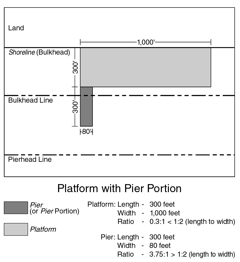
platform
A “platform” is a pile-supported or solid-core structure at the water's edge, or a portion thereof, that:
(a) is permanently connected to the land; and
(b) has a seaward dimension that does not exceed 50 percent of its dimension along the land to which it is connected.
(62 - 112)
platform, existing
An “existing platform” is a platform where at least 75 percent of its surface is visible in the April 1988 Lockwood, Kessler and Bartlett aerial photographs of New York City.
platform, new
A “new platform” is any platform other than an existing platform.
plaza
A "plaza" is an open area for public use on a zoning lot developed, from December 15, 1961, to June 11, 1996, in accordance with the requirements set forth in APPENDIX E, Section E27-50 (PLAZA STANDARDS OF 1961), of this Resolution.
plaza, public
A “public plaza” is an open area for public use provided in accordance with the requirements set forth in Section 37-70, inclusive.
plaza, residential
A "residential plaza" is an open area for public use on a zoning lot developed from March 2, 1977, to October 17, 2007, in accordance with the requirements set forth in APPENDIX E, Article II, Chapter 7, of this Resolution.
plaza, urban
An "urban plaza" is an open area for public use on a zoning lot developed, from April 16, 1975, to June 11, 1996, in accordance with plans certified by the Chairperson of the City Planning Commission or, from June 13, 1996, to October 17, 2007, in accordance with the requirements set forth in APPENDIX E, Section E37-04, of this Resolution.
predominant or predominantly
“Predominant” or “predominantly” shall mean that a use or a group of uses comprises at least 75 percent of the total floor area of the building or on the zoning lot or, in the case of open uses, the lot area or pier water coverage, as applicable.
predominantly built-up area
A "predominantly built-up area" is a block entirely within R4 or R5 Districts, including a Commercial District mapped within such Residence Districts, having a maximum area of four acres with buildings on zoning lots comprising 50 percent or more of the area of the block. However, a predominantly built-up area shall not include a block which is located partly in an R4A, R4-1, R4B, R5B or R5D District.
All such buildings shall have certificates of occupancy or other evidence acceptable to the Commissioner of Buildings issued not less than three years prior to the date of application for a building permit. Special optional regulations applying only to zoning lots of not more than 1.5 acres in a predominantly built-up area are set forth in the following Sections:
Section 23-143 (Optional regulations for predominantly built-up areas)
Section 23-22 (Maximum Number of Dwelling Units)
Section 23-44 (Permitted Obstructions in Required Yards or Rear Yard Equivalents)
Section 23-631 (General provisions)
Section 25-22 (Requirements Where Individual Parking Facilities Are Provided)
Section 25-23 (Requirements Where Group Parking Facilities Are Provided)
The regulations applicable to a predominantly built-up area shall not apply to any zoning lot occupied as of October 21, 1987, by a single- or two-family detached or semi-detached residence where 75 percent or more of the aggregate length of the block fronts in residential use, on both sides of the street facing each other, are occupied by such residences as of October 21, 1987. However, the regulations applicable to a predominantly built-up area may apply to such zoning lots where 75 percent or more of the aggregate length of the block fronts facing each other, on both sides of the street, is comprised of zoning lots occupied as of October 21, 1987, by commercial or manufacturing uses.
Furthermore, the regulations applicable to a predominantly built-up area shall continue to apply in the Special Coney Island Mixed Use District and the Special Ocean Parkway District, and in areas subject to the provisions of paragraph (d) of Section 23-16 (Special Floor Area and Lot Coverage Provisions for Certain Areas).
primary entrance
“Primary entrances” are the principal entrances to a building utilized for day-to-day pedestrian ingress and egress. Other entrances solely used for freight, service or emergency egress shall not constitute a primary entrance.
primary street frontage
FROM 37-311: For the purposes of Section 37-30, inclusive, a “primary street frontage” shall be the portion of the ground floor level street frontage along any of the following:
(a) a wide street;
(b) a narrow street where a Commercial District is mapped along an entire block frontage; or
(c) a narrow street within 50 feet of a wide street.
primary street frontage
FROM 64-11: For the purposes of applying the provisions of Section 64-322(c), a “primary street frontage” shall include:
(a) in Commercial Districts, frontages that meet the criteria for a “primary street frontage” as defined in Section 37-311;
(b) in M1 Districts paired with Residence Districts, frontages along:
(1) wide streets;
(2) narrow streets within 50 feet of a wide street; and
(3) narrrow streets where an M1 District paired with a Residence District is mapped along an entire block frontage; and
(c) frontages where non-residential uses are required at the ground-floor level pursuant to a Special Purpose District or waterfront public access area.
primary transit-adjacent sites
FROM 66-11: For the purposes of this Chapter, “primary transit-adjacent sites” shall refer to transit-adjacent sites that have a lot area of 5,000 square feet or more.
private road
A "private road" is a right-of-way, other than a street, that provides vehicular access from a street to five or more dwelling units that are within buildings or building segments that are located wholly beyond 50 feet of a street line or street setback line.
An individual driveway serving fewer than five parking spaces shall not be considered a private road.
However, in lower density growth management areas, a private road is a right-of-way, other than a street, that provides vehicular access from a street to:
(a) three or more buildings or building segments located wholly beyond 50 feet of a street line or street setback line; or
(b) one or two buildings or building segments located wholly beyond 50 feet of a street line or street setback line that contain five or more dwelling units.
Regulations for private roads are located in Sections 26-00 (APPLICABILITY OF THIS CHAPTER) and 37-10 (SPECIAL REGULATIONS FOR PRIVATE ROADS AND LOWER DENSITY GROWTH MANAGEMENT AREAS).
profile curve
A curved line on the daylight evaluation chart rising from the intersection of the curved line representing an elevation angle of 72 degrees with the vertical line at the far lot line. The profile curve is used to evaluate a building's obstruction of the sky as seen in profile from the vantage point.
profile encroachment
The space on the daylight evaluation chart which, when viewed from the vantage point, is on the far side of the profile curve and which is blocked by the projection of the building on the daylight evaluation chart. (See illustration of Profile Encroachment)
|
|

public park
A "public park" is any publicly owned park, playground, beach, parkway or roadway within the jurisdiction and control of the Commissioner of Parks and Recreation, except for park strips or malls in a street the roadways of which are not within the Commissioner's jurisdiction and control.
public parking garage
A "public parking garage" is a building or other structure:
(a) that provides parking or storage for motor vehicles, but not for the dead storage of motor vehicles; and
(b) some or all of whose parking spaces are non-accessory.
A public parking garage may include accessory off-street parking spaces limited to such spaces that are accessory to other uses on the same zoning lot.
Minor repairs incidental to the parking or storage of motor vehicles is a permitted accessory use.
public parking lot
A "public parking lot" is any open area on a zoning lot that is:
(a) used for the parking or storage of motor vehicles, but not for the dead storage of motor vehicles; and
(b) not accessory to a use on the same or another zoning lot.
Minor repairs incidental to the parking or storage of motor vehicles is a permitted accessory use.
public plaza
see plaza, public
Public Realm Improvement Fund
For the purposes of Section 81-60, inclusive, the “Public Realm Improvement Fund” (the “Fund”) shall be a separate interest-bearing account established for the deposit of contributions made when developments or, where permitted, enlargements on qualifying sites in the East Midtown Subdistrict will exceed the basic maximum floor area ratio set forth in Section 81-64 (Special Floor Area Provisions for Qualifying Sites) through their utilization of the provisions of Sections 81-642 (Transfer of development rights from landmarks to qualifying sites), 81-643 (Special provisions for retaining non-complying floor area in commercial buildings) or 81-685 (Special permit to modify qualifying site provisions). The Fund shall be utilized, at the discretion of the Public Realm Improvement Fund Governing Group, to provide funding to implement improvements to the East Midtown Subdistrict, and its immediate vicinity, in the Borough of Manhattan. Upon receipt of any contribution, the Public Realm Improvement Fund Governing Group or the Department of City Planning shall notify the Comptroller of the City of New York and the Speaker of the New York City Council and promptly deposit it into the Fund.
Public Realm Improvement Fund Development Rights Valuation
For the purposes of Section 81-60, inclusive, the “Public Realm Improvement Fund Development Rights Valuation” (“Development Rights Valuation”) shall be a value per square foot of transferable development rights in the East Midtown Subdistrict, which shall provide a basis for establishing a minimum contribution to the Public Realm Improvement Fund. As of August 9, 2017, the Development Rights Valuation shall be set at $307.45 per square foot.
When proposing an adjustment to the Development Rights Valuation, the Department of City Planning shall undertake a transferrable development rights valuation study conducted by qualified professionals utilizing industry best practices. The City Planning Commission shall, by rule, review and adjust the Development Rights Valuation, pursuant to the City Administrative Procedures Act not more than once every three years and not less than once every five years.
An applicant, upon written request to the Commission, may request a transferable development rights valuation study to evaluate whether the Development Rights Valuation should be modified for a particular qualifying site based upon any recent changes in market conditions within the Subdistrict. The study must be paid for by the applicant and completed within a one-year timeframe. The Department of City Planning shall initiate the study, to be conducted by qualified professionals utilizing industry best practices. Where the study demonstrates that the value of the development rights for the qualifying site is less than the Development Rights Valuation, the Commission shall, by certification, and in connection with a certification pursuant to Section 81-642 (Transfer of development rights from landmarks to qualifying sites), modify the required contribution to 20 percent of the adjusted valuation.
Public Realm Improvement Fund Governing Group
For the purposes of Section 81-60, inclusive, the “Public Realm Improvement Fund Governing Group” (the “Governing Group”) shall be established to administer the Public Realm Improvement Fund (the “Fund”), and shall consist of 13 members: seven members shall be representatives of City agencies, appointed by and serving at the pleasure of the Mayor; one member shall be a representative of a citywide civic organization, appointed by the Office of the Manhattan Borough President; one member shall be a representative of the Office of the Manhattan Borough President; one member shall be a representative of the New York City Council member representing the City Council district encompassing the largest portion of the East Midtown Subdistrict; one member shall be a representative of the Speaker of the City Council; one member shall be a representative of Manhattan Community Board 5; and one member shall be a representative of Manhattan Community Board 6. The Governing Group shall be a local development corporation, organized pursuant to the New York State Not-for-Profit Corporation Law, and affiliated with City government for purposes of the New York State Public Authorities Law, whose organizational purpose shall be limited solely to the purposes set forth in this Chapter. Each member shall have one vote, and all Governing Group decisions, as set forth below, shall be upon a majority vote at a public meeting at which a quorum is present. A quorum shall consist of a majority of the members.
The purpose of the Governing Group shall be to bolster and enhance East Midtown’s status as a premier central business district with a high-quality public realm, by allocating funds from the Fund to implement public realm improvement projects. The Governing Group shall establish and maintain a Public Realm Improvement Concept Plan (“Concept Plan”) for the purpose of creating a list of priority improvements, and shall have the authority to amend such Concept Plan, and associated list of improvements, as necessary. All priority improvements in the Concept Plan shall meet the criteria set forth in Section 81-683 (Criteria for improvements in the Public Realm Improvement Concept Plan).
Establishment of the Concept Plan, amendment of the Concept Plan, calendaring of items for a vote to fund, and designation of funding for a specific public realm improvement on the Concept Plan shall be decisions requiring a majority vote of the Governing Group at a meeting at which a quorum is present. If only members of the Governing Group appointed by the Mayor vote to calendar a particular public realm improvement for a vote to fund it, the Governing Group shall conduct a public hearing on the matter prior to such improvement being placed on the calendar for vote. In addition, if any member of the Governing Group puts forth a proposed public realm improvement, discussion of such improvement shall be added to the agenda of the next public meeting. Establishment of the initial Concept Plan shall be completed no later than November 1, 2017.
In the event that more than 20 million dollars remains in the Fund for more than three years, the Governing Group shall be required to hold a vote either to fund a public realm improvement project or to retain the funds.
The Governing Group shall adopt procedures for the conduct of its activities. Such procedures shall be consistent with the requirements of the New York State Open Meetings Law (Article 7, NYS Public Officers Law), which procedures shall also be consistent with the goals of the Subdistrict. Those procedures shall be publicly available by posting on the Department of City Planning’s website, and shall include rules requiring reporting and transparency including, but not limited to, the following: procedures on the adoption and amendment of the concept plan and opportunity for public comment thereon; requirements to provide a transcript or recording of all public meetings and hearings; and transparency and annual reporting requirements concerning deposits into and expenditures from the Fund. The Governing Group shall annually update the Concept Plan by providing a list of all projects on the Concept Plan to date, those added or removed in the past year, the dollar amount of funds designated to each project on the Concept Plan, to the extent available, the estimated cost of each project on the Concept Plan, and the schedule for all projects for which a decision to designate funding has been made by the Governing Group. Such annual update shall be posted on the Department of City Planning’s website no later than January 15 of each calendar year following the establishment of the initial Concept Plan. All meetings of the Governing Group shall be open to the public with advance public notice provided of all meetings and public hearings.
publicly accessible open area
A “publicly accessible open area” is an open area for public use on a zoning lot developed in accordance with the requirements of a plaza, residential plaza, urban plaza or public plaza.
publicly accessible private street
FROM 127-04:
publicly accessible private street
A “publicly accessible private street” is a way specified on Map 2 in the Appendix to this Chapter that functions as a street for the purposes of general public use, including vehicular and pedestrian traffic, and is open and unobstructed from its ground level to the sky, except by streetscape elements required or permitted by the provisions of this Chapter.
publicly accessible private street
FROM 127-04:
publicly accessible private street
A “publicly accessible private street” is a way specified on Map 2 in the Appendix to this Chapter that functions as a street for the purposes of general public use, including vehicular and pedestrian traffic, and is open and unobstructed from its ground level to the sky, except by streetscape elements required or permitted by the provisions of this Chapter.
qualifying building
[From Section 143-02]:
For the purposes of this Chapter, a “qualifying building” shall be any building where, prior to December 15, 2021:
(a) such building contained at least 60,000 square feet of floor area; and
(b) at least 20 percent of the floor area within such building was allocated to non-residential floor area, as such term is utilized in Section 143-14.
qualifying building
[From Section 88-01]:
For the purposes of this Chapter, a “qualifying building” shall be any building that contained at least 70,000 square feet of floor area on March 20, 2013.
qualifying exterior wall thickness
“Qualifying exterior wall thickness” shall refer to the floor space occupied by exterior wall thickness added to a building existing on December 6, 2023, where:
- for over-cladding projects: such wall thickness is added to a wall existing on December 6, 2023, up to a maximum of 12 inches, provided the added wall thickness has an aggregate thermal resistance (R-value) of at least 1.5 per inch; or
- for re-cladding projects: such wall thickness is located within a new wall that replaces a wall existing on December 6, 2023, where the qualifying portion is occupied by additional thickness relative to the previous wall, up to a maximum of 12 additional inches, and provided that the new wall shall comply with the minimum prescriptive and mandatory requirements for building thermal envelopes of the current New York City Energy Conservation Code.
Qualifying exterior wall thickness shall also include exterior wall thickness in exterior walls constructed between April 30, 2012 and December 6, 2023 where such exterior wall thickness satisfied the requirements of paragraph (12)(ii) of the definition of floor area in effect at the time of construction.
Qualifying exterior wall thickness need not exclusively contain insulating materials and may include wall thickness occupied by conduits, ductwork, pipes, or other essential non-insulating building components.
qualifying ground floor
A “qualifying ground floor” shall refer to the ground floor of a development or enlargement of a Quality Housing building on a zoning lot, or portion thereof, where:
(a) the level of the finished floor of the second story is 13 feet or more above the level of the adjoining sidewalk; and
(b) for buildings in the following Districts that do not meet the criteria set forth in paragraph (a) of Section 23-664, such ground floor provides supplemental ground floor enhancements in accordance with paragraph (b)(2) of Section 23-662 or paragraph (b)(2) of Section 35-652, as applicable:
(1) R6A, R6B, R7A, R7D, R7X, R8A, R8X, R9X or R10A Districts located outside the Manhattan Core; or
(2) Commercial Districts mapped within, or with a residential equivalent of, R6A, R6B, R7A, R7D, R7X, R8A, R8X, R9X or R10A Districts located outside the Manhattan Core.
qualifying rooftop greenhouse
A “qualifying rooftop greenhouse” shall refer to any rooftop greenhouse that:
- is located on the roof of a building that does not contain residences;
- will be used primarily for cultivation of plants; and
- has roofs and walls consisting of at least 70 percent transparent materials.
Such qualifying rooftop greenhouses shall be exempt from the definition of floor area, and shall be considered a permitted obstruction to height and setback, as set forth in the applicable district regulations.
Rooftop greenhouses which do not meet the requirements of this definition may also be permitted pursuant to the underlying district regulations, but shall not be exempt from the definition of floor area, and shall not be permitted obstructions to height and setback.
qualifying site
For the purposes of Section 81-60, inclusive, a “qualifying site” shall refer to a zoning lot:
(a) that is not located in the Vanderbilt Corridor Subarea;
(b) that has frontage along a wide street;
(c) where, at the time of development or, where permitted, enlargement, either:
(1) at least 75 feet of such zoning lot’s wide street frontage is clear of buildings or other structures; or
(2) the entire block frontage along such wide street is occupied by one or more landmark buildings or other structures; or
(3) such zoning lot’s wide street frontage is occupied by an existing easement volume that is being preserved, or reconfigured in accordance with Section 81-673 (Mass transit access);
(d) where a building is developed or, where permitted, enlarged, in accordance with the floor area provisions of Section 81-64 (Special Floor Area Provisions for Qualifying Sites), and such development or, where permitted, enlargement exceeds the basic maximum floor area set forth in Row A of the table in Section 81-64 and such building or publicly accessible space occupies the cleared area in paragraph (c)(1) of this definition, unless the provisions of paragraphs (c)(2) or (c)(3) apply;
(e) where a maximum of 20 percent of the floor area permitted on such zoning lot is allocated to residential uses; and
(f) where such building being developed or, where permitted, enlarged, complies with the performance requirements of paragraph (a) and the publicly accessible space requirements of paragraph (b) of Section 81-681 (Mandatory requirements for qualifying sites).
qualifying transit improvement sites
[From Section 66-11]:
For the purposes of this Chapter, “qualifying transit improvement sites” shall refer to zoning lots that are:
(a) located in one of the following zoning districts:
(1) R9 or R10 Districts;
(2) Commercial Districts mapped within, or with an equivalent of an R9 or R10 District;
(3) M1 Districts paired with an R9 or R10 District; or
(4) M1-6 Districts; and
(b) located wholly or partially within the following distance from a mass transit station:
(1) 500 feet for such zoning lots outside of Central Business Districts; or
(2) 1,500 feet for such zoning lots and mass transit stations within Central Business Districts.
Such distance shall be measured from the outermost extent of the mass transit station. For the purposes of such calculation, the outermost extent may include buildings containing easement volumes serving such mass transit station.
Quality Housing building
A “Quality Housing building” is a building, developed, enlarged, extended or converted, pursuant to the Quality Housing Program. The Quality Housing Program consists of specific bulk requirements set forth for Quality Housing buildings in Article II, Chapter 3 and Article III, Chapter 5. Where a building adheres to such bulk requirements, which, depending on the requirements for the zoning district, may be required or may be an option, additional standards and requirements, as set forth in Article II, Chapter 8, apply in conjunction with such bulk provisions for Quality Housing buildings.
Quality Housing building segment
A “Quality Housing building segment” is a building segment, developed, enlarged, extended or converted pursuant to the Quality Housing Program.
railroad or transit air space
"Railroad or transit air space" is space directly over a railroad or transit right-of-way or yard, which right-of-way or yard was open, except for structures accommodating activities incidental to its use as a right-of-way or yard, and not otherwise covered over by any building or other structure on or after September 27, 1962.
rear lot line
see lot line, rear
rear sky exposure plane
see sky exposure plane, rear
rear wall line
A "rear wall line" is that portion of a line drawn parallel to a front lot line at a distance equal to the greatest depth between the rear wall of a building and the front lot line, from which, when viewed directly from above, lines perpendicular to a street wall line may be drawn.
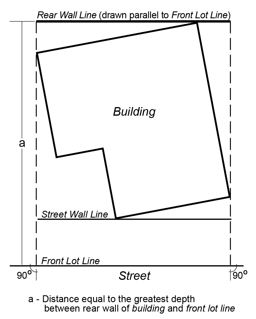
REAR WALL LINE
rear wall line level
"Rear wall line level" is the mean level of the natural grade at the rear wall line.
rear yard
see yard, rear
rear yard equivalent
see yard equivalent, rear
rear yard line
see yard line, rear
receiving lot
For the purposes of Section 81-60, inclusive, a “receiving lot” shall mean a zoning lot to which development rights of a granting lot are transferred. Such receiving lot may receive a transfer of development rights pursuant to Sections 81-632 (Special permit for transfer of development rights from landmarks to the Vanderbilt Corridor Subarea), 81-642 (Transfer of development rights from landmarks to qualifying sites), or 81-653 (Special permit for transfer of development rights from landmarks to non-qualifying sites).
reference plane
The “reference plane” is a horizontal plane from which the height and setback regulations governing a building or other structure may be measured, in accordance with certain provisions of this Chapter. The reference plane shall not be located above the first story above flood elevation, as applicable.
For zoning lots located wholly or partially within the high-risk flood zone, the reference plane may be established at any level between the flood-resistant construction elevation and a height of 10 feet above the base plane or curb level, as applicable. However, where the flood-resistant construction elevation exceeds a height of 10 feet above the base plane or curb level, as applicable, the reference plane may be established at the flood-resistant construction elevation.
For zoning lots located wholly or partially within the moderate-risk flood zone, the reference plane may be established at any level between the flood-resistant construction elevation and a height of five feet above the base plane or curb level, as applicable.
residence district
A "Residence District" includes any district whose designation begins with the letter "R."
For example, an "R6" District includes any district whose designation begins with the symbol "R6."
residence, or residential
A "residence" is one or more dwelling units or rooming units, including common spaces such as hallways, lobbies, stairways, laundry facilities, recreation areas or storage areas. A residence may, for example, consist of one-family or two-family houses, multiple dwellings, boarding or rooming houses, or apartment hotels. However, residences do not include:
(a) such transient accommodations as transient hotels, motels or tourist cabins, or trailer camps;
(b) non-profit hospital staff dwellings; or
(c) student dormitories, fraternity or sorority student houses, monasteries or convents, long-term care facilities, or other living or sleeping accommodations in community facility buildings or portions of buildings used for community facility uses.
"Residential" means pertaining to a residence.
residential building
A "residential building" is a building used only for a residential use.
residential plaza
see plaza, residential
residential use
A "residential use" is any use listed in Use Group 1 or 2.
rooming unit
A "rooming unit" consists of any "living room," as defined in the Multiple Dwelling Law, in a residential building or a residential portion of a building, that is:
(a) in a "class B multiple dwelling," a "rooming house," or a "furnished room house" as defined in the Multiple Dwelling Law; or
(b) used "for class B occupancy," as defined in the Housing Maintenance Code; or
(c) used for "single room occupancy," as defined in the Multiple Dwelling Law; or
(d) occupied by a "boarder," "roomer" or "lodger," as defined in the Housing Maintenance Code, provided, however, that if not more than two such boarders, roomers or lodgers reside within a dwelling unit, the room or rooms occupied by such boarders, roomers or lodgers shall be counted as part of the dwelling unit and shall not be counted as rooming units; or
(e) any other "living room" in a residential building or a residential portion of a building which is not a dwelling unit or part of a dwelling unit.
rooms
"Rooms" shall consist of "living rooms," as defined in the Multiple Dwelling Law.
sale price
For the purposes of Section 81-60, inclusive, “sale price” shall mean the total consideration exchanged for transferred floor area pursuant to certification to transfer development rights from zoning lots occupied by landmark buildings or other structures within the East Midtown Subdistrict to a qualifying site. The total consideration shall include all consideration as defined in Chapter 21 of the Administrative Code of the City of New York and Title 19 of the Rules of the City of New York, as they may be amended, or their successor provisions, whether or not subject to tax under that Chapter. The total consideration shall also include any other compensation in whatever form received in exchange for the floor area, including contingent consideration. A valuation prepared pursuant to procedures established by rule of the City Planning Commission or the New York City Department of Finance shall be required for all consideration in a form other than cash. The application for certification shall include affidavits from the buyer and seller, attesting under penalty of perjury, that all of the terms of the transaction and all the consideration have been disclosed, and may be subject to audit.
scenic view
FROM 102-01:
scenic view
A "scenic view" is an outstanding or unique view from a mapped public park or an esplanade or a mapped public place which is protected by the regulations of this Chapter. Scenic views shall be limited to:
(a) distant landscapes of scenic grandeur which contain natural features such as hills, palisades or similar features;
(b) outstanding views of large bodies of water such as rivers, streams, lakes, harbors, waterfalls or similar aquatic features; or
(c) panoramic views of the waterfront profile of the skyline formed by built and natural elements.
The minimum horizontal distance between the scenic view and a view reference line shall be at least 1,500 feet and shall not contain distractions which reduce the quality of such view. The specific view to be preserved under the regulation of this Special Scenic View District shall be described and made part of this Chapter.
school
A "school" is:
(a) an institution providing full-time day instruction and a course of study that meets the requirements of Sections 3204, 3205 and 3210 of the New York State Education Law; or
(b) a nursery school or kindergarten:
(1) whose annual session does not exceed the school sessions for full-time day schools prescribed in Section 3204 of the New York State Education Law; and
(2) which is operated by the Department of Education or any established religious organization as part of an elementary school; or
(c) a child care service operating under a permit issued pursuant to Section 47.03 of the New York City Health Code.
seaward lot
A “seaward lot” is the portion of a waterfront zoning lot located seaward of the bulkhead line, except for any land above water included as part of the upland lot.
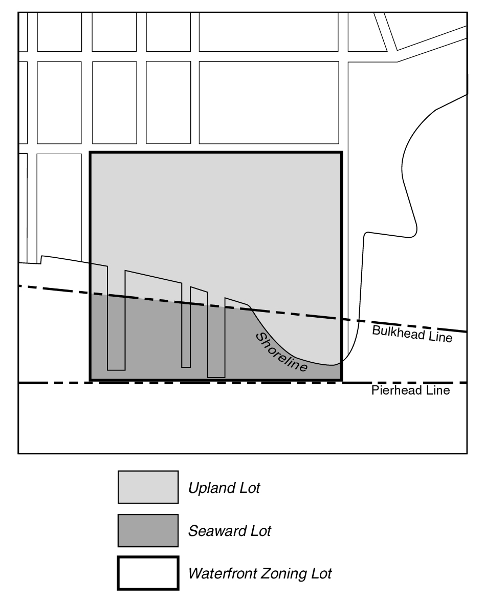
SEAWARD/UPLAND LOTS
(62 - 11.4)
secondary transit-adjacent sites
FROM 66-11: For the purposes of this Chapter, “secondary transit-adjacent sites” shall refer to transit-adjacent sites that have a lot area of less than 5,000 square feet.
select community facility uses
From Section 139-01: For the purposes of this Chapter, the following community facility uses shall also be considered “select community facility uses”:
Houses of worship, rectories or parish houses; and
Health facilities requiring approval under Article 28 of the Public Health Law of the State of New York that, prior to July 10, 1974, have received approval of Part I of the required application from the Commissioner of Health.
self-service storage facility
A “self-service storage facility” is a moving or storage office, or a warehouse establishment, as listed in Use Group 16D, for the purpose of storing personal property, where:
(a) such facility is partitioned into individual, securely subdivided space for lease; or
(b) such facility consists of enclosed or unenclosed floor space which is subdivided by secured bins, boxes, containers, pods or other mobile or stationary storage devices; and
(c) such floor space or storage devices are less than 300 square feet in area and are to be leased or rented to persons or businesses to access, store or remove property on a self-service basis.
semi-detached (building)
A "semi-detached" building is a building that abuts only one other building, other than an attached building, on an adjoining zoning lot along only one side lot line and which is surrounded on all other sides by yards, other open areas or street lines.
Setback line
A line drawn in plan parallel to a street line and showing for a given building height the minimum depth to which a building is required to be set back from the street line by the applicable depth to height chart in Section 81-263 (Standard setback requirements). Required setbacks, established by the chart, increase with the building's height.
(See illustration of Setback Line and Half-Setback Line)
[SETBACK LINE AND HALF-SETBACK LINE - two images]
severe disaster
A “severe disaster” shall include any event within any boundary of the City of New York, for which the Mayor proclaims a local state of emergency, or the Governor declares a disaster emergency.
Shore public walkway
FROM 116-01:
Shore public walkway
A "shore public walkway" is a linear public access area along the shore or water edges of a platform on a waterfront zoning lot.
shore public walkway
A “shore public walkway” is a linear public access area running alongside the shore or water edges of a platform on a waterfront zoning lot.
shoreline
The "shoreline" is the mean high water line, as determined in accordance with the procedure set forth by the National Oceanic and Atmospheric Administration of the U.S. Department of Commerce.
shoreline adjacent lot
[From Section 142-04]:
For the purposes of this Chapter, a “shoreline adjacent lot” shall refer to a waterfront zoning lot with a shoreline length of more than 100 feet, or any zoning lot that has entered into a binding agreement to improve and maintain a waterfront public access area for an adjoining waterfront zoning lot.
show window
A "show window" is a window or opening in the exterior wall of any portion of a building used for business purposes, through which merchandise, services or business are displayed or advertised. A window glazed with transparent glass in the business portion of a building, any part of which window is less than six feet above the sidewalk or the established sidewalk grade beneath the window, shall be a show window.
side lot line
see lot line, side
side lot ribbon
A "side lot ribbon" is that portion of the zoning lot that is contiguous to, and extends along the entire length of, a side lot line from the street line to an intersecting rear lot line, side lot line or other street line. Where a side lot ribbon is used for a common driveway serving two zoning lots, the side lot ribbon may occupy space on both sides of a side lot line.
side yard
See yard, side
sign
A "sign" is any writing (including letter, word or numeral), pictorial representation (including illustration or decoration), emblem (including device, symbol or trademark), flag, (including banner or pennant) or any other figure of similar character, that:
(a) is a structure or any part thereof, or is attached to, painted on, or in any other manner represented on a building or other structure;
(b) is used to announce, direct attention to or advertise; and
(c) is visible from outside a building. A sign shall include writing, representation or other figures of similar character, within a building, only when illuminated and located in a window.
However, non-illuminated signs containing solely non-commercial copy with a total surface area not exceeding 12 square feet on any zoning lot, including memorial tablets or signs displayed for the direction or convenience of the public, shall not be subject to the provisions of this Resolution.
sign band
FROM 122-01:
Sign band
A "sign band" is a horizontal band which extends the full length of the street wall of a building, and is located between 8 feet and 14 feet above curb level.
sign with indirect illumination
A "sign with indirect illumination" is any illuminated non-flashing sign whose illumination is derived entirely from an external artificial source and is so arranged that no direct rays of light are projected from such artificial source into residences or streets.
sign, advertising
An "advertising sign" is a sign that directs attention to a business, profession, commodity, service or entertainment conducted, sold, or offered elsewhere than upon the same zoning lot and is not accessory to a use located on the zoning lot.
sign, flashing
A "flashing sign" is any illuminated sign, whether stationary, revolving or rotating, that exhibits changing light or color effects, provided that revolving or rotating signs that exhibit no changing light or color effects other than those produced by revolution or rotation, shall be deemed flashing signs only if they exhibit sudden or marked changes in such light or color effects.
Illuminated signs that indicate the time, temperature, weather or other similar information shall not be considered flashing signs, provided that:
(a) the total surface area of such sign is not greater than 16 square feet;
(b) the vertical dimension of any letter or number is not greater than 24 inches; and
(c) color or intensity of light is constant except for periodic changes in the information displayed, which occur not more frequently than once every minute.
sign, illuminated
An "illuminated sign" is a sign designed to give forth any artificial light or reflect such light from an artificial source.
sign, surface area of
see surface area (of a sign)
single-family residence
A "single-family residence" is a building containing only one dwelling unit, and occupied by only one family.
Site alteration
Site alteration
A "site alteration" is an alteration on any vacant tract of land, land with minor improvements or any tract of land containing buildings or other structures which includes land contour work, topographic modifications, removal of topsoil, vegetation, excavating, filling, dumping, changes in existing drainage systems, improvements in public rights-of-way, relocation of erratic boulders or modification of any other natural features, whether or not a permit is required from the Department of Buildings, the Department of Transportation or other public agencies.
Site alteration
FROM 107-01:
Site alteration
A "site alteration" is an alteration on any vacant tract of land, land with minor improvements or any tract of land containing buildings or other structures, which includes permanent topographic modifications, removal of topsoil, removal of trees of six-inch caliper or more, excavating, filling, dumping, changes in existing drainage systems, whether or not a permit is required from the Department of Buildings or other public agencies.
Site alteration
Site alteration
For the purposes of this Chapter, a "site alteration" is an alteration on any vacant tract of land, land with minor improvements or any tract of land containing buildings or other structures. Site alterations shall include the following:
(a) removal of topsoil;
(b) excavating, filling, land contour work and other topographic modifications where the ground elevation of the land existing on June 30, 1987, is modified by two feet or more;
(c) dumping, changes in existing drainage systems and changes in grade, alignment or width of public rights-of-way; or
(d) removal of vegetation beyond 15 feet of the foundation of an existing building, except when the plant materials' continued presence would create hazards or dangers (such as an area affected by storm or plant disease) to persons, property or other plant material which it would not be possible or practical to eliminate by pruning or routine maintenance.
sky exposure plane or front sky exposure plane
A "sky exposure plane" or "front sky exposure plane" is an imaginary inclined plane:
(a) beginning above the street line (or, where so indicated, above the front yard line) at a height set forth in the district regulations; and
(b) rising over a zoning lot at a ratio of vertical distance to horizontal distance set forth in the district regulations.
sky exposure plane, rear
(a) beginning above a line at a distance from and parallel to the street line and at a height set forth in the district regulations; and
(b) rising over a zoning lot at a ratio of vertical distance to horizontal distance set forth in the district regulations.
SoHo-NoHo Arts Fund
[From Section 143-02]:
For the purposes of this Chapter, the “SoHo-NoHo Arts Fund” (the “Arts Fund”) shall be a separate interest-bearing account established for the deposit of contributions made when converting joint living-work quarters for artists to residences through in accordance with the provisions of Section 143-13 (Joint Living-Work Quarters for Artists). Funds within the SoHo-NoHo Arts Fund shall be allocated by the New York City Department of Cultural Affairs, or a not-for-profit entity designated by the Department of Cultural Affairs, to support arts programming, projects, organizations, and facilities that promote the public presence of the arts within the Special District and surrounding neighborhoods and extend the cultural legacy of SoHo and NoHo generally. Such allocation should prioritize under-resourced organizations and under-served areas within Lower Manhattan neighborhoods south of 14th Street.
No later than June 30 of each year, the Department of Cultural Affairs shall submit a report to the Speaker of the City Council detailing the amount of money deposited into the SoHo-NoHo Arts Fund and any expenditure of funds.
Special 125th Street District
The "Special 125th Street District" is a Special Purpose District designated by the number "125" in which special regulations set forth in Article IX, Chapter 7, apply.
Special Battery Park City District
The "Special Battery Park City District" is a Special Purpose District designated by the letters "BPC" in which special regulations set forth in Article VIII, Chapter 4, apply.
Special Bay Ridge District
The "Special Bay Ridge District" is a Special Purpose District designated by the letters "BR" in which special regulations set forth in Article XI, Chapter 4, apply.
Special Bay Street Corridor District
The "Special Bay Street Corridor District" is a Special Purpose District designated by the letters "BSC" in which special regulations set forth in Article XIII, Chapter 5, apply.
Special Brooklyn Navy Yard District
The “Special Brooklyn Navy Yard District” is a Special Purpose District designated by the letters “BNY” in which special regulations set forth in Article XIV, Chapter 4, apply.
Special City Island District
The "Special City Island District" is a Special Purpose District designated by the letters "CD" in which special regulations set forth in Article XI, Chapter 2, apply.
Special Clinton District
The "Special Clinton District" is a Special Purpose District designated by the letters "CL" in which special regulations set forth in Article IX, Chapter 6, apply.
Special Coastal Risk District
The “Special Coastal Risk District” is a Special Purpose District designated by the letters “CR” in which special regulations set forth in Article XIII, Chapter 7, apply.
Special College Point District
The “Special College Point District” is a Special Purpose District designated by the letters “CP” in which special regulations set forth in Article XII, Chapter 6, apply.
Special Coney Island District
The “Special Coney Island District” is a Special Purpose District designated by the letters “CI” in which special regulations set forth in Article XIII, Chapter 1, apply.
Special Coney Island Mixed Use District
The "Special Coney Island Mixed Use District" is a Special Purpose District designated by the letters "CO" in which special regulations set forth in Article X, Chapter 6, apply.
Special Downtown Brooklyn District
The "Special Downtown Brooklyn District" is a Special Purpose District designated by the letters "DB" in which special regulations set forth in Article X, Chapter 1, apply.
Special Downtown Far Rockaway District
The “Special Downtown Far Rockaway District” is a Special Purpose District designated by the letters “DFR” in which special regulations set forth in Article XIII, Chapter 6, apply.
Special Downtown Jamaica District
The "Special Downtown Jamaica District" is a Special Purpose District designated by the letters "DJ" in which special regulations set forth in Article XI, Chapter 5, apply.
Special East Harlem Corridors District
The "Special East Harlem Corridors District" is a Special Purpose District designated by the letters "EHC" in which special regulations set forth in Article XIII, Chapter 8, apply.
Special Enhanced Commercial District
The "Special Enhanced Commercial District" is a Special Purpose District designated by the letters "EC" in which special regulations set forth in Article XIII, Chapter 2, apply.
Special Flushing Waterfront District
The "Special Flushing Waterfront District" is a Special Purpose District designated by the letters "FW" in which special regulations set forth in Article XII, Chapter 7, apply.
Special Forest Hills District
The "Special Forest Hills District" is a Special Purpose District designated by the letters "FH" in which special regulations set forth in Article VIII, Chapter 6, apply.
Special Garment Center District
The "Special Garment Center District" is a Special Purpose District designated by the letters "GC" in which special regulations set forth in Article XII, Chapter 1, apply.
Special Governors Island District
The “Special Governors Island District” is a Special Purpose District designated by the letters “GI” in which the special regulations set forth in Article XIII, Chapter 4, apply.
Special Gowanus Mixed Use District
Special Grand Concourse Preservation District
The "Special Grand Concourse Preservation District" is a Special Purpose District designated by the letter "C" in which special regulations set forth in Article XII, Chapter 2, apply.
Special Harlem River Waterfront District
The "Special Harlem River Waterfront District" is a Special Purpose District designated by the letters "HRW" in which special regulations set forth in Article VIII, Chapter 7, apply.
special height locations
Special Hillsides Preservation District
The "Special Hillsides Preservation District" is a Special Purpose District mapped in Staten Island designated by the letters "HS" in which special regulations set forth in Article XI, Chapter 9, apply.
Special Hudson River Park District
The “Special Hudson River Park District” is a Special Purpose District designated by the letters “HRP” in which special regulations set forth in Article VIII, Chapter 9, apply.
Special Hudson Square District
The “Special Hudson Square District” is a Special Purpose District designated by the letters “HSQ,” in which special regulations set forth in Article VIII, Chapter 8, apply.
Special Hudson Yards District
The "Special Hudson Yards District" is a Special Purpose District designated by the letters "HY" in which special regulations set forth in Article IX, Chapter 3, apply.
Special Hunts Point District
The "Special Hunts Point District" is a Special Purpose District designated by the letters "HP" in which special regulations set forth in Article X, Chapter 8, apply.
Special Inwood District
The "Special Inwood District" is a Special Purpose District designated by the letters "IN" in which special regulations set forth in Article XIV, Chapter 2, apply.
Special Jerome Corridor District
The "Special Jerome Corridor District" is a Special Purpose District designated by the letter "J" in which special regulations set forth in Article XIV, Chapter 1, apply.
Special Limited Commercial District
The "Special Limited Commercial District" is a Special Purpose District designated by the letters "LC" in which special regulations set forth in Article VIII, Chapter 3, apply.
Special Lincoln Square District
The "Special Lincoln Square District" is a Special Purpose District designated by the letter "L" in which special regulations set forth in Article VIII, Chapter 2, apply.
Special Little Italy District
The "Special Little Italy District" is a Special Purpose District designated by the letters "LI" in which special regulations set forth in Article X, Chapter 9, apply.
Special Long Island City Mixed Use District
The "Special Long Island City Mixed Use District" is a Special Purpose District designated by the letters "LIC" in which special regulations set forth in Article XI, Chapter 7, apply.
Special Lower Manhattan District
The "Special Lower Manhattan District" is a Special Purpose District designated by the letters "LM" in which special regulations set forth in Article IX, Chapter 1, apply.
Special Madison Avenue Preservation District
The "Special Madison Avenue Preservation District" is a Special Purpose District designated by the letters "MP" in which special regulations set forth in Article IX, Chapter 9, apply.
Special Manhattanville Mixed Use District
The “Special Manhattanville Mixed Use District” is a Special Purpose District designated by the letters “MMU” in which special regulations set forth in Article X, Chapter 4, apply.
Special Midtown District
The "Special Midtown District" is a Special Purpose District designated by the letters "MiD" in which special regulations set forth in Article VIII, Chapter 1, apply.
Special Mixed Use District
The "Special Mixed Use District" is a Special Purpose District designated by the letters "MX" in which special regulations set forth in Article XII, Chapter 3, apply. The Special Mixed Use District appears on the zoning maps superimposed on paired M1 and Residence Districts, and its regulations supplement or modify those of the M1 and Residence Districts. The Special Mixed Use District includes any district that begins with the letters “MX.”
Special Natural Area District
The "Special Natural Area District" is a Special Purpose District designated by the letters "NA" in which special regulations set forth in Article X, Chapter 5, apply. The Special Natural Area District includes any district whose designation begins with the letters "NA”.
Special Ocean Parkway District
The "Special Ocean Parkway District" is a Special Purpose District designated by the letters "OP" in which special regulations set forth in Article XI, Chapter 3, apply.
Special Park Improvement District
The "Special Park Improvement District" is a Special Purpose District designated by the letters "PI" in which special regulations set forth in Article IX, Chapter 2, apply.
Special Planned Community Preservation District
The "Special Planned Community Preservation District" is a Special Purpose District designated by the letters "PC" in which special regulations set forth in Article X, Chapter 3, apply.
Special Scenic View District
The "Special Scenic View District" is a Special Purpose District designated by the letters "SV" in which the special regulations set forth in Article X, Chapter 2, apply.
Special Sheepshead Bay District
The "Special Sheepshead Bay District" is a Special Purpose District designated by the letters "SB" in which special regulations set forth in Article IX, Chapter 4, apply.
Special SoHo-NoHo Mixed Use District
The “Special SoHo-NoHo Mixed Use District” is a Special Purpose District designated by the letters “SNX” in which special regulations set forth in Article XIV, Chapter 3, apply.
Special South Richmond Development District
The "Special South Richmond Development District" is a Special Purpose District designated by the letters "SR" in which special regulations set forth in Article X, Chapter 7, apply.
Special Southern Hunters Point District
The “Special Southern Hunters Point District” is a Special Purpose District designated by the letters “SHP” in which special regulations set forth in Article XII, Chapter 5, apply.
Special Southern Roosevelt Island District
The “Special Southern Roosevelt Island District” is a Special Purpose District designated by the letters “SRI” in which special regulations set forth in Article XIII, Chapter 3, apply.
Special St. George District
The “Special St. George District” is a Special Purpose District designated by the letters “SG” in which special regulations set forth in Article XII, Chapter 8, apply.
Special Stapleton Waterfront District
The "Special Stapleton Waterfront District" is a Special Purpose District designated by the letters "SW" in which special regulations set forth in Article XI, Chapter 6, apply.
Special Transit Land Use District
A "Special Transit Land Use District" is a Special Purpose District designated by the letters "TA" in which special regulations set forth in Article IX, Chapter 5, apply.
Special Tribeca Mixed Use District
The "Special Tribeca Mixed Use District" is a Special Purpose District designated by the letters "TMU" in which special regulations set forth in Article XI, Chapter 1, apply.
Special Union Square District
The "Special Union Square District" is a Special Purpose District, designated by the letters "US" in which special regulations set forth in Article XI, Chapter 8, apply.
Special United Nations Development District
The "Special United Nations Development District" is a Special Purpose District designated by the letter "U" in which special regulations set forth in Article VIII, Chapter 5, apply.
Special West Chelsea District
The “Special West Chelsea District” is a Special Purpose District designated by the letters “WCh” in which special regulations set forth in Article IX, Chapter 8, apply.
Special Willets Point District
The “Special Willets Point District” is a Special Purpose District designated by the letters “WP” in which special regulations set forth in Article XII, Chapter 4, apply.
staging area
FROM 105-01:
staging area
A "staging area" is any area on a zoning lot used during the construction of a development, enlargement or site alteration for the purposes of stockpiling soil or construction materials; storing, cleaning or servicing construction equipment, vehicles or tools; or storing leachable construction products, gases or other materials used to clean or service vehicles, equipment or tools.
staging area
FROM 119-01:
staging area
A "staging area" is any area on a zoning lot or other tract of land used during the construction of a development, enlargement or site alteration for the purposes of stockpiling soil or construction materials; storing, cleaning or servicing construction equipment, vehicles or tools; or storing leachable construction products, gases or other materials used to clean or service vehicles, equipment or tools.
steep slope
FROM 105-01:
steep slope
A "steep slope" is a portion of a zoning lot with an incline of 25 percent or greater. However, a portion of a zoning lot with an incline of 25 percent or greater shall not be considered a steep slope if it occupies an area of less than 200 square feet or has a dimension of less than 10 feet, measured along the horizontal plane, unless such portions in the aggregate equal 10 percent or more of the area of the zoning lot.
steep slope
FROM 119-01:
steep slope
A "steep slope" is a portion of a zoning lot or other tract of land with an incline of 25 percent or greater. However, a portion of a zoning lot or other tract of land with an incline of 25 percent or greater shall not be considered a steep slope if it occupies an area of less than 200 square feet or has a dimension of less than 10 feet, measured along the horizontal plane, unless such portions in the aggregate equal 10 percent or more of the area of the zoning lot.
steep slope buffer
FROM 105-01:
steep slope buffer
A "steep slope buffer" is a 15-foot wide area having a slope of less than 25 percent that adjoins the entire length of the crest of a steep slope.
steep slope buffer
FROM 119-01:
steep slope buffer
A "steep slope buffer" is a 15-foot wide area having a slope of less than 25 percent that adjoins the entire length of the crest of a steep slope.
story
A "story" is that part of a building between the surface of a floor (whether or not counted for purposes of computing floor area ratio) and the ceiling immediately above. However, a cellar shall not be considered a story. Furthermore, attic space that is not floor area pursuant to Section 12-10 (DEFINITIONS) shall not be considered a story.
street
A "street" is:
(a) a way established on the City Map; or
(b) a way designed or intended for general public use, connecting two ways established on the City Map, that:
(1) performs the functions usually associated with a way established on the City Map;
(2) is at least 50 feet in width throughout its entire length; and
(3) is covenanted by its owner to remain open and unobstructed throughout the life of any building or use that depends thereon to satisfy any requirement of this Resolution; or
(c) any other open area intended for general public use and providing a principal means of approach for vehicles or pedestrians from a way established on the City Map to a building or other structure, that:
(1) performs the functions usually associated with a way established on the City Map;
(2) is at least 50 feet in width throughout its entire length;
(3) is approved by the City Planning Commission as a "street" to satisfy any requirement of this Resolution; and
(4) is covenanted by its owner to remain open and unobstructed throughout the life of any building or use that depends thereon to satisfy any requirement of this Resolution; or
(d) any other public way that on December 15, 1961, was performing the functions usually associated with a way established on the City Map; or
(e) a covered pedestrian space that directly links two parallel or substantially parallel ways established on the City Map, for which a floor area bonus may be awarded or was awarded pursuant to a prior definition of such amenity, that may, by certification of the City Planning Commission, be deemed to be a street, provided the Commission finds that:
(1) no portion of such space is located within 50 feet of the intersection of two ways established on the City Map;
(2) such space is unobstructed for a minimum width of 15 feet and a minimum height of 15 feet, except for enclosures at the entrances;
(3) such space is located at an elevation no more than five feet above or below curb level; and
(4) the space functions as a street providing access to another street, shops and other uses, and that such access is graphically and visually evident to the pedestrian.
All provisions of this Resolution shall continue to be applicable to such space without being modified, varied or affected by the qualification of such space as a street.
The City Planning Commission may prescribe appropriate conditions and safeguards to achieve public utilization of the street.
For purposes of paragraphs (a), (b), (c) and (d) of this definition, a private road, or a driveway that serves only to give vehicular access to an accessory parking or loading facility, or to allow vehicles to take on or discharge passengers at the entrance to a building, shall not be considered a street.
Street frontage zone
A portion of a zoning lot which lies within an area bounded by a continuous front lot line and either the center line of the block or a line 100 feet distant from and parallel to that front lot line, whichever is closer to that front lot line. There shall be a street frontage zone for each zoning lot street frontage.
(See illustration of Street Frontage Zones)
[STREET FRONTAGE ZONES - image]
street line
A "street line" is a lot line separating a street from other land.
A street setback line supersedes the street line in the application of yard, height and setback, and court regulations.
street setback line
A "street setback line" is a line shown on the City Map in the Borough of Staten Island, or in Community District 10 in the Borough of Queens. A street setback line shall not be located within a mapped street area.
A street setback line supersedes the street line in the application of yard, height and setback, and court regulations.
No building or other structure shall be erected within the area between street setback lines fronting on the same street, or between a street setback line and the opposite mapped street line if no street setback line exists. Any existing building or other structure within this area may be continued, changed, extended or structurally altered but shall not be enlarged.
street wall
A "street wall" is a wall or portion of a wall of a building facing a street.
street wall line
A "street wall line" is that portion of a line drawn parallel to a front lot line at a distance equal to the shallowest depth between the street wall of a building and the front lot line, from which, when viewed directly from above, lines perpendicular to the front lot line may be drawn to a street wall.
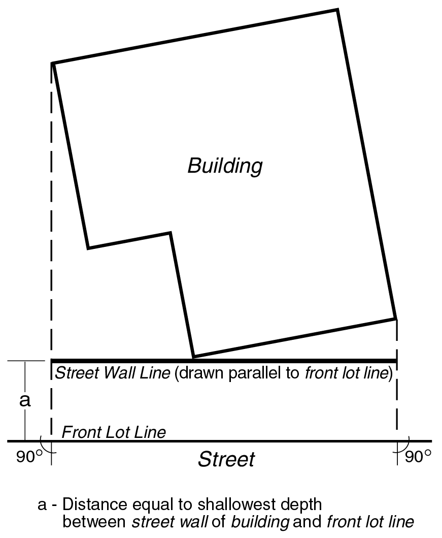
STREET WALL LINE
street wall line level
"Street wall line level" is the mean level of the natural grade at the street wall line. On corner lots, street wall line level is the average of the mean levels of the natural grade of each street wall line. On through lots, street wall line level is determined separately for each street frontage to a distance midway between such streets.
street, narrow
A "narrow street" is any street less than 75 feet wide.
street, wide
A "wide street" is any street 75 feet or more in width. In C5-3, C6-4 or C6-6 Districts, when a front lot line of a zoning lot adjoins a portion of a street whose average width is 75 feet or more and whose minimum width is 65 feet, such portion of a street may be considered a wide street; or when a front lot line adjoins a portion of a street 70 feet or more in width, which is between two portions of a street 75 feet or more in width, and which portion is less than 700 feet in length, such portion may be considered a wide street, and in that case, for the purposes of the height and setback regulations and the measurement of any publicly accessible open area or arcade, the street line shall be considered to be a continuous line connecting the respective street lines of the nearest portions of the street which are 75 feet or more in width.
In Community District 7 in the Borough of Manhattan, the roadways of Broadway between West 94th and West 97th Streets which are separated by mapped public park shall each be considered a wide street.
supplemental public access area
A “supplemental public access area” is a public access area provided on a waterfront zoning lot, in addition to other required public access areas, in order to fulfill the required waterfront public access area requirements. A supplemental public access area shall not include a shore public walkway or an upland connection.
surface area (of a sign)
The "surface area" of a sign shall be the entire area within a single continuous perimeter enclosing the extreme limits of writing, representation, emblem, or any figure of similar character, together with any material or color forming an integral part of the display or used to differentiate such sign from the background against which it is placed. In any event, the supports or uprights on which such sign is supported shall not be included in determining the surface area of a sign.
When two signs of the same shape and dimensions are mounted or displayed back-to-back and parallel on a single free-standing structural frame, only one of such signs shall be included in computing the total surface area of the two signs.
When a double-faced sign projects from the wall of a building, and its two sides are located not more than 28 inches apart at the widest point and not more than 18 inches apart at the narrowest point, and display identical writing or other representation, the surface area shall include only one of the sides. Any additional side of a multi-faced sign shall be considered as a separate sign for purposes of computing the total surface area of the sign.
ten-foot setback line
A line which is parallel to the street line at a depth of 10 feet and represents the minimum distance any portion of a building exceeding the maximum height at the street line is required to be set back from the street line. A greater setback distance may be required by a setback line or a half-setback line depending upon the building height for which such setback line or half-setback line is established.
[TEN-FOOT SETBACK LINE ON AN ENCROACHMENT GRID - 2 images]
through block arcade
A "through block arcade" is a continuous area within a building connecting one street with another street, publicly accessible open area or arcade adjacent to the street. This area may be enclosed in whole or in part and must have a minimum width of 20 feet and a minimum average height of 20 feet. Such a through block arcade shall, at either end, be at the same level as the street, publicly accessible open area or arcade that it adjoins.
through block public plaza
A “through block public plaza” is a public plaza or portion of a public plaza that is not a corner public plaza and that connects two streets that are parallel or within 45 degrees of being parallel to each other.
through lot
see lot, through
tidal wetland area
A “tidal wetland area” is an area planted with species tolerant of saline water inundation that is located between the mean low water line and the landward edge of the stabilized natural shore or bulkhead. Such area may be used to satisfy requirements for waterfront yards, shore public walkways and planting in this Chapter.
Tier I site
Tier I site
A "Tier I site" is a zoning lot or other tract of land having an average percent of slope of less than 10 percent.
Tier I site
FROM 119-01:
Tier I site
A "Tier I site" is a zoning lot or other tract of land having an average percent of slope of less than 10 percent.
Tier II site
Tier II site
A "Tier II site" is a zoning lot or other tract of land having an average percent of slope equal to or greater than 10 percent.
Tier II site
FROM 119-01:
Tier II site
A "Tier II site" is a zoning lot or other tract of land having an average percent of slope equal to or greater than 10 percent.
topsoil
FROM 105-01:
topsoil
"Topsoil" is soil containing undisturbed humus and organic matter capable of sustaining vigorous plant growth and is generally the top six inches of soil.
topsoil
FROM 119-01:
topsoil
"Topsoil" is soil containing undisturbed humus and organic matter capable of sustaining vigorous plant growth and is generally the top six inches of soil.
tourist cabin
see motel or tourist cabin
trailer
A "trailer" is a vehicle standing on wheels or rigid supports that is used for living or sleeping purposes.
trailer camp
A "trailer camp" is a zoning lot or portion thereof used or designated for the use of two or more trailers.
transient hotel
see hotel, transient
transit agency
FROM 66-11: For the purposes of this Chapter, a “transit agency” shall refer to any governmental agency with jurisdiction over the affected mass transit station.
transit volume
FROM 66-11: For the purposes of this Chapter, a “transit volume” shall refer to an area of a transit-adjacent site where, pursuant to the provisions of this Chapter, a transit agency has determined transit or pedestrian circulation improvements are needed for a mass transit station. Such transit volume may be used to accommodate easement volumes or clear paths.
Transit Zone
The “Transit Zone” is the area within the boundaries shown in APPENDIX I of this Resolution where special parking provisions apply.
transit-adjacent sites
[From Section 66-11]:
For the purposes of this Chapter, “transit-adjacent sites” shall refer to zoning lots that are located within 50 feet of a mass transit station and located in eligible zoning districts. Transit-adjacent sites include primary transit-adjacent sites and secondary transit-adjacent sites.
transitional surfaces
The "transitional surfaces" are imaginary inclined planes extending upward and outward from the side edges of all approach surfaces, and from lines parallel to, 500 feet from, and at the same level as the center line of each runway, which:
(a) rise at a slope of one foot in height for every seven feet of horizontal distance measured in a vertical plane at right angles to the center line of the runway; and
(b) extend to the point of intersection with the horizontal surface or the conical surface.
tree credit
FROM 105-01:
tree credit
A "tree credit" is a credit for preserving an existing tree of six-inch caliper or more that is counted towards a tree preservation requirement or a credit for a newly planted tree of three-inch caliper or more that is counted towards a tree planting requirement.
tree credit
FROM 119-01:
tree credit
A "tree credit" is a credit for preserving an existing tree of six-inch caliper or more which is counted toward a tree preservation requirement, or a credit for a newly planted tree of three-inch caliper or more which is counted toward a tree planting requirement.
tree credit
FROM 107-01:
tree credit
A “tree credit” is a credit for preserving an existing tree or for planting a new tree which is counted towards tree requirements.
tree protection plan
FROM 105-01:
tree protection plan
A "tree protection plan" is a plan that modifies the area of no disturbance around a tree proposed for preservation while protecting and preserving the tree during construction. A tree protection plan is prepared by an arborist certified by the International Society of Arborculturists (ISA) or equivalent professional organization that includes:
(a) a survey of the current condition and health of such trees of six-inch caliper or more;
(b) methods for tree protection and preservation based on best management practices, including the prevention of damage due to compaction, grade and drainage pattern changes and tunneling for utilities;
(c) a schedule for site monitoring during construction;
(d) a procedure to communicate protection measures to contractor and workers; and
(e) post-construction treatment.
tree protection plan
FROM 119-01:
tree protection plan
A "tree protection plan" is a plan that modifies the area of no disturbance around a tree proposed for preservation while protecting and preserving the tree during construction. A tree protection plan is prepared by an arborist certified by the International Society of Arborculturists (ISA) or equivalent professional organization that includes:
(a) a survey of the current condition and health of such trees of six-inch caliper or more;
(b) methods for tree protection and preservation based on best management practices, including the prevention of damage due to compaction, grade and drainage pattern changes and tunneling for utilities;
(c) a schedule for site monitoring during construction;
(d) a procedure to communicate protection measures to contractor and workers; and
(e) post-construction treatment.
two-family residence
A "two-family residence" is a building containing not more than two dwelling units, and occupied by only two families.
ultra low energy building
An “ultra-low-energy building” shall refer to a building which complies with requirements for ultra-low-energy usage. At time of application for plan approval to the Commissioner of Buildings, materials shall be submitted demonstrating:
- that such building shall comply with the requirements of Local Law 154 of 2021, as such requirements would apply to a new building where an application for the approval of construction documents is submitted to the Commissioner of Buildings after July 1, 2027;
- that such building shall be designed and constructed to reduce energy use:
- for buildings three stories or less:
such building shall be a net-zero energy building which shall produce energy onsite from renewable energy sources in an amount equal to or greater than such building’s total energy needs; or - for all other buildings:
energy performance that exceeds by at least 15 percent the energy performance of such a building if designed and constructed according to an approved modeling method set forth in the New York City Energy Conservation Code.
- for buildings three stories or less:
- that a registered design professional has verified that the proposed design will meet the requirements of this definition; and
- that plans have been prepared to conduct, as relevant: inspections, equipment commissioning, and airtightness testing during the construction phase.
No final certificate of occupancy shall be issued for such a building until a report prepared by a registered design professional has been submitted to the Commissioner of Buildings verifying that the building has completed and successfully passed the inspections, commissioning, and testing set forth in paragraph (d) of this definition.
The Department of City Planning may, by rule, update or supplement the requirements of this section exclusively for the purpose of keeping such requirements aligned with advancing technological and construction practices. Such updates may only modify the statutory reference in paragraph (a) of this definition; the specified parameters and reference standards of paragraph (b)(2) of this definition.
unlicensed physical treatment establishment
An unlicensed physical treatment establishment is any establishment that offers or advertises or is equipped or arranged so as to provide as part of its services, whether as a principal use or as an accessory use, massages, body rubs, alcohol rubs, baths or other similar treatment administered by a person that is not a healthcare professional licensed by the State of New York to provide such service, or under the supervision of such licensee and working in a manner allowed by the license. However, unlicensed physical treatment establishments shall not include barbershops or beauty parlors that offer massage to the scalp, the face, the neck or shoulders only.
Unlicensed physical treatment establishments shall not be permitted in any District.
upland connection
FROM 116-01:
upland connection
An "upland connection" is a pedestrian way which provides a public access route from the Esplanade or a shore public walkway to a public sidewalk within a public street. Required upland connections are shown in the District Plan, Map 5 (Upland Connections and Visual Corridors), in Appendix A of this Chapter.
upland connection
An “upland connection” is a pedestrian way which provides a public access route from a shore public walkway to a public sidewalk within an open and accessible street, public park or other accessible public place.
upland lot
An “upland lot” is the portion of a waterfront zoning lot located landward of the bulkhead line. Where a portion of the shoreline projects seaward of the bulkhead line, such land above water shall be included as part of the upland lot (see illustration of Seaward/Upland Lots).
upper street wall
FROM 104-01:
upper street wall
“Upper street wall” is that portion of the street wall of a building that extends from the lower street wall to the maximum building height set forth for each Parcel in the Base Plane and Building Height Table in Appendix B of this Chapter, or the height of the building, whichever is less.
urban plaza
see plaza, urban
use
A "use" is:
(a) any purpose for which a building or other structure or an open tract of land may be designed, arranged, intended, maintained or occupied; or
(b) any activity, occupation, business or operation carried on, or intended to be carried on, in a building or other structure or on an open tract of land.
vantage point
A point on the center line of the street bounding the zoning lot and located 250 feet from the intersection of the extension of the zoning lot's far lot line with the center line of the street. (See illustration of Far Lot Line and Vantage Point)
vantage street
A street bounding the zoning lot and on the center line of which a vantage point is located.
view framing line
FROM 102-01:
view framing line
The "view framing line" is a line or lines which establish the outer edge of the scenic view to be protected. For each scenic view, the view framing line or lines and their elevation are to be located and identified and made part of this Chapter.
view plane
FROM 102-01:
view plane
A "view plane" is an imaginary plane above which no obstruction shall be permitted within a Special Scenic View District unless authorized by the City Planning Commission. Position of the view plane may be conical surfaces. Such view plane or planes are established by joining the view reference line with the view framing lines as illustrated below:
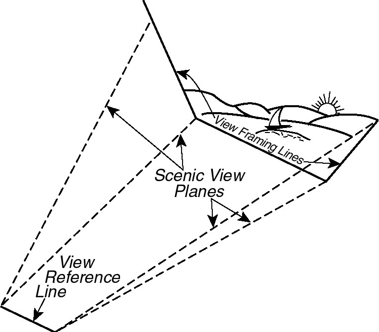

View planes and their elevation, length and slopes applicable to each Special Scenic View District are to be located and identified and made part of this Chapter.
view reference line
FROM 102-01:
view reference line
The "view reference line" is a line within a mapped public park or an esplanade or a mapped public place from which at any point an outstanding scenic view may be observed. A view reference line and its elevation applicable to each Special Scenic View District are to be located and identified and made part of this Chapter.
The mapped public park or an esplanade or a mapped public place in which such view reference line is located shall be directly accessible from a street.
visual corridor
FROM 116-01:
visual corridor
A "visual corridor" is a public street or tract of land within a block that provides a direct and unobstructed view to the water from a vantage point within a public street. Required visual corridors are shown in the District Plan, Map 5 and Map 6 (Location of Visual Corridor in Subarea E) in Appendix A of this Chapter.
visual corridor
A “visual corridor” is a public street or open area within one or more zoning lots that provides a direct and unobstructed view to the water from a vantage point within a public street, public park or other public place.
water coverage
“Water coverage” is the portion of a zoning lot seaward of the shoreline that, when viewed directly from above, would be covered by a pier, platform or floating structure, including portions of buildings or other structures projecting over the water from such structures. Water coverage shall not include docking or navigational appurtenances which may project from the aforementioned structures.
waterfront area
The "waterfront area" is the geographical area comprising all blocks between the pierhead line and a line 800 feet landward from the shoreline. Where such line intersects a block, the entire block shall be included and the waterfront area boundary shall coincide with the centerline of the landward boundary street or other block boundary. Notwithstanding the above, any zoning lot, the boundaries of which were established prior to November 1, 1993, and which is not closer than 1,200 feet from the shoreline at any point and which does not abut a waterfront public park, shall not be included in the waterfront area.
For the purposes of this definition, only blocks along waterways that have a minimum width of 100 feet between opposite shorelines, with no portion downstream less than 100 feet in width, shall be included within the waterfront area. However, blocks bounding Dutch Kills and the portion of the Bronx River located south of the prolongation of East 172nd Street, shall be included within the waterfront area.
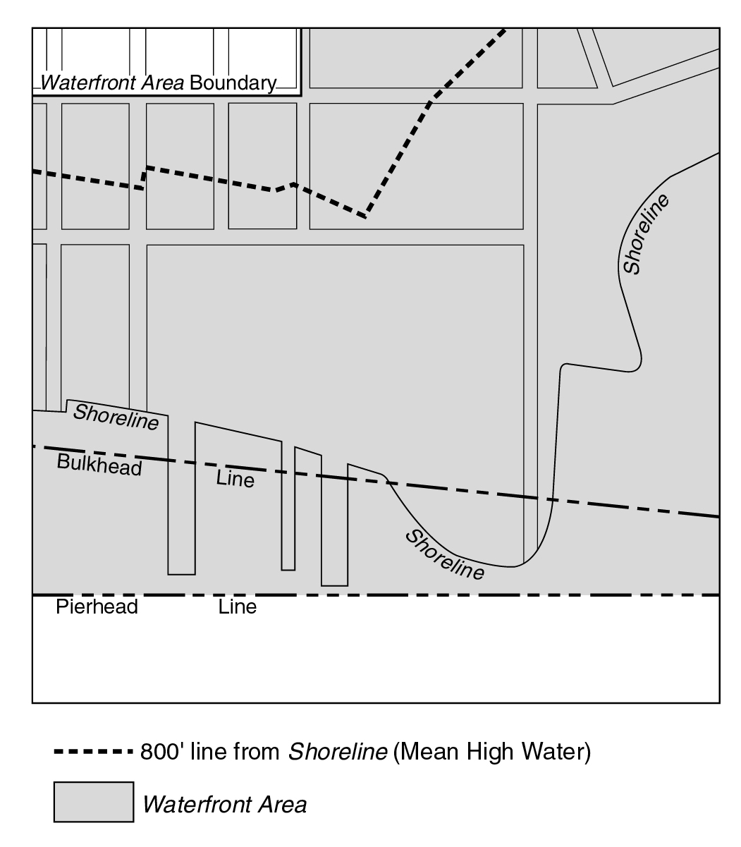
WATERFRONT AREA
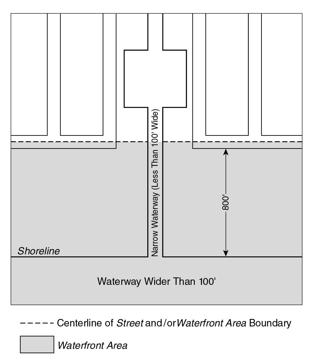
NARROW WATERWAY EXCLUSION
waterfront block or waterfront zoning lot
A “waterfront block” or "waterfront zoning lot” is a block or zoning lot in the waterfront area having a boundary at grade coincident with or seaward of the shoreline. For the purposes of this Chapter:
(a) a block within the waterfront area shall include the land within a street that is not improved or open to the public, and such street shall not form the boundary of a block;
(b) a block within the waterfront area that abuts a public park along the waterfront shall be deemed to be part of a waterfront block; and
(c) a zoning lot shall include the land within any street that is not improved or open to the public and which is in the same ownership as that of any contiguous land.
However, any block or zoning lot in the waterfront area having a boundary within or coincident with the boundaries of the Gowanus Canal, as shown on the City Map, shall be a waterfront block or waterfront zoning lot, respectively.
Any zoning lot, the boundaries of which were established prior to November 1, 1993, and which is not closer than 1,200 feet from the shoreline at any point and which does not abut a public park along the waterfront, shall be deemed outside of the waterfront block.
waterfront esplanade
FROM 107-01:
waterfront esplanade
The "waterfront esplanade" is a pedestrian way to be provided for public use within the open space network along the Raritan Bay waterfront, as shown on the District Plan (Map 3 in Appendix A).
waterfront public access area
A “waterfront public access area” is the portion of a zoning lot improved for public access. It may include any of the following: a shore public walkway, upland connection, supplemental public access area or public access area on a pier or floating structure.
waterfront yard
A “waterfront yard” is that portion of a waterfront zoning lot extending open and unobstructed from the lowest level to the sky along the entire length of the shoreline, stabilized natural shore, bulkhead or water edge of a platform, as applicable, for a depth or width as set forth in this Chapter.
wide street
see street, wide
width of outer court
see court, width of outer
width of outer court
see court, width of outer
yard
A "yard" is that portion of a zoning lot extending open and unobstructed from the lowest level to the sky along the entire length of a lot line, and from the lot line for a depth or width set forth in the applicable district yard regulations.
Where a street setback line is shown on the City Map the yard extends along the entire length of the street setback line, and from the street setback line for a depth or width set forth in the applicable district yard regulations.
yard equivalent, rear
A "rear yard equivalent" is an open area which may be required on a through lot as an alternative to a required rear yard.
yard line, front
A "front yard line" is a line drawn parallel to a front lot line at a distance therefrom equal to the depth of a required front yard.
yard line, front, level (of)
The "front yard line level" is the mean level of that portion of the front yard line from which, when viewed directly from above, lines perpendicular to the front yard line may be drawn to a street wall. On corner lots, the front yard line level is the mean of the front yard line levels.
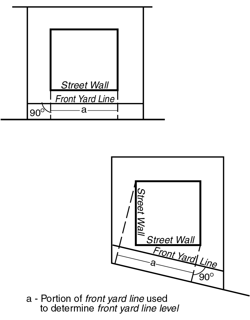
FRONT YARD LINE LEVEL
yard line, rear
A "rear yard line" is a line drawn parallel to a rear lot line at a distance therefrom equal to the depth of a required rear yard.
yard, front
A "front yard" is a yard extending along the full length of a front lot line.
In the case of a corner lot, any yard extending along the full length of a street line shall be considered a front yard.
yard, rear
A "rear yard" is a yard extending for the full length of a rear lot line.
yard, side
A "side yard" is a yard extending along a side lot line from the required front yard (or from the front lot line if no front yard is required) to the required rear yard (or to the rear lot line, if no rear yard is required). In the case of a corner lot, any yard which is not a front yard shall be considered a side yard.
zero lot line building
A "zero lot line building" is a building that abuts only one side lot line and does not abut another building on the same or an adjoining zoning lot and which is surrounded on all sides but one by yards, other open area or street lines on the zoning lot. However, accessory buildings permitted pursuant to Section 23-44 (Permitted Obstructions in Required Yards or Rear Yard Equivalents) may be permitted to abut a zero lot line building on an adjoining zoning lot.
Zone A, Zone B, Zone C
"Zone A," "Zone B" and "Zone C" are zones on an encroachment grid defined as follows:
(a) Zone A is the free zone.
(b) Zone B, an encroachment zone, is the zone, exclusive of any area in Zone A and any area closer to the street line than the ten-foot setback line, which lies between the setback line and either the half-setback line or the ten-foot setback line, whichever is further from the street line.
(c) Zone C, an encroachment zone and penalty zone, is the zone, exclusive of any area closer to the street line than the ten-foot setback line, which lies between the half-setback line and the ten-foot setback line.
zoning lot
A "zoning lot" is either:
(a) a lot of record existing on December 15, 1961, or any applicable subsequent amendment thereto;
(b) a tract of land, either unsubdivided or consisting of two or more contiguous lots of record, located within a single block, which, on December 15, 1961, or any applicable subsequent amendment thereto, was in single ownership;
(c) a tract of land, either unsubdivided or consisting of two or more lots of record contiguous for a minimum of 10 linear feet, located within a single block, which at the time of filing for a building permit (or, if no building permit is required, at the time of the filing for a certificate of occupancy) is under single fee ownership and with respect to which each party having any interest therein is a party in interest (as defined herein); or
(d) a tract of land, either unsubdivided or consisting of two or more lots of record contiguous for a minimum of 10 linear feet, located within a single block, which at the time of filing for a building permit (or, if no building permit is required, at the time of filing for a certificate of occupancy) is declared to be a tract of land to be treated as one zoning lot for the purpose of this Resolution. Such declaration shall be made in one written Declaration of Restrictions covering all of such tract of land or in separate written Declarations of Restrictions covering parts of such tract of land and which in the aggregate cover the entire tract of land comprising the zoning lot. Any Declaration of Restrictions or Declarations of Restrictions which individually or collectively cover a tract of land are referred to herein as "Declarations." Each Declaration shall be executed by each party in interest (as defined herein) in the portion of such tract of land covered by such Declaration (excepting any such party as shall have waived its right to execute such Declaration in a written instrument executed by such party in recordable form and recorded at or prior to the recording of the Declaration). Each Declaration and waiver of right to execute a Declaration shall be recorded in the Conveyances Section of the Office of the City Register or, if applicable, the County Clerk's Office of the county in which such tract of land is located, against each lot of record constituting a portion of the land covered by such Declaration.
A zoning lot, therefore, may or may not coincide with a lot as shown on the official tax map of the City of New York, or on any recorded subdivision plat or deed.
Parcels within City-owned tracts of land located in Broad Channel within the boundaries of Community Board 14 in the Borough of Queens that were numerically identified for leasing purposes on maps filed in the Office of Borough President prior to December 15, 1961, may be considered as individual lots of record as of September 10, 1981.
(e) For purposes of the provisions of paragraph (c) hereof:
(1) prior to issuing a building permit or a certificate of occupancy, as the case may be, the Department of Buildings shall be furnished with a certificate issued to the applicant therefor by a title insurance company licensed to do business in the State of New York showing that each party having any interest in the subject tract of land is a party in interest (as defined herein); except that where the City of New York is a fee owner, such certificate may be issued by the New York City Law Department; and
(2) a "party in interest" in the tract of land shall include only (W) the fee owner thereof, (X) the holder of any enforceable recorded interest superior to that of the fee owner and which could result in such holder obtaining possession of all or substantially all of such tract of land, (Y) the holder of any enforceable recorded interest in all or substantially all of such tract of land which would be adversely affected by the development thereof and (Z) the holder of any unrecorded interest in all or substantially all of such tract of land which would be superior to and adversely affected by the development thereof and which would be disclosed by a physical inspection of the tract of land.
(f) For purposes of the provisions of paragraph (d) hereof:
(1) prior to issuing a building permit or a certificate of occupancy, as the case may be, the Department of Buildings shall be furnished with a certificate issued to the applicant therefor by a title insurance company licensed to do business in the State of New York showing that each party in interest (excepting those parties waiving their respective rights to join therein, as set forth in this definition) has executed the Declaration and that the same, as well as each such waiver, have been duly recorded; except that where the City of New York is a fee owner, such certificate may be issued by the New York City Law Department;
(2) the Buildings Department, in issuing a building permit for construction of a building or other structure on the zoning lot declared pursuant to paragraph (d) above or, if no building permit is required, in issuing a certificate of occupancy for such building or other structure, shall accept an application for same from and, if all conditions for issuance of same are fulfilled, shall issue same to any party to the Declaration;
(3) by their execution and recording of a Declaration, the parties to the Declaration, and all parties who have waived their respective rights to execute such Declaration, shall be deemed to have agreed that no breach by any party to the Declaration, or any agreement ancillary thereto, shall have any effect on the treatment of the tract of land covered by the Declaration as one zoning lot for purposes of this Resolution and such tract of land shall be treated as one zoning lot unless such zoning lot is subdivided in accordance with the provisions of this Resolution; and
(4) a "party in interest" in the portion of the tract of land covered by a Declaration shall include only (W) the fee owner or owners thereof, (X) the holder of any enforceable recorded interest in all or part thereof which would be superior to the Declaration and which could result in such holder obtaining possession of any portion of such tract of land, (Y) the holder of any enforceable recorded interest in all or part thereof which would be adversely affected by the Declaration, and (Z) the holder of any unrecorded interest in all or part thereof which would be superior to and adversely affected by the Declaration and which would be disclosed by a physical inspection of the portion of the tract of land covered by the Declaration.
A zoning lot may be subdivided into two or more zoning lots, provided that all resulting zoning lots and all buildings thereon shall comply with all of the applicable provisions of this Resolution. If such zoning lot, however, is occupied by a non-complying building, such zoning lot may be subdivided provided such subdivision does not create a new non-compliance or increase the degree of non-compliance of such building.
Where ownership of a zoning lot or portion thereof was effected prior to the effective date of this amendment, as evidenced by an attorney's affidavit, any development, enlargement or alteration on such zoning lot may be based upon such prior effected ownership as then defined in the zoning lot definition of Section 12-10. Such prior leasehold agreements shall be duly recorded prior to August 1, 1978.
Prior to the issuance of any permit for a development or enlargement pursuant to this Resolution a complete metes and bounds of the zoning lot, the tax lot number, the block number and the ownership of the zoning lot as set forth in paragraphs (a), (b), (c) and (d) herein shall be recorded by the applicant in the Conveyances Section of the Office of the City Register (or, if applicable, the County Clerk's Office) of the county in which the said zoning lot is located. The zoning lot definition in effect prior to the effective date of this amendment shall continue to apply to Board of Standards and Appeals approvals in effect at the effective date hereof.
zoning maps
"Zoning maps" are the maps incorporated into the provisions of this Resolution in accordance with the provisions of Section 11-14 (Incorporation of Maps).